GeoPard Joins EIT Food Accelerator for Agtech Innovation

GeoPard is thrilled to announce their participation in the EIT Food Accelerator Network program. This program is aimed at accelerating the technology revolution in agriculture and food systems.

GeoPard is excited to collaborate with other agtech and foodtech startups from all over Europe and is looking forward to taking part in the upcoming cohort, which is set to start this week.

The EIT Food Accelerator Network is a European network of support programs for startups, which aims to foster innovation and entrepreneurship in the agrifood sector.

The program provides training, mentorship, and resources to help startups accelerate their tech validation and business growth towards successful market adoption.

As a participant in the EIT Food Accelerator Network program, GeoPard Agriculture will have access to a wide range of resources and support, including expert mentorship, investment opportunities, and networking events.

GeoPard Joins EIT Food

This will enable the company to accelerate its development and growth, and to bring its innovative solutions to the market more quickly.

GeoPard Agriculture is a technology company that specializes in precision agriculture. The company’s solutions help farmers optimize their crop management by providing real-time data and analytics on soil moisture, temperature, and other key factors.

By using GeoPard’s technology, farmers can make more informed decisions about irrigation, fertilization, and other important aspects of crop management, which can ultimately lead to higher yields and better quality crops.

The company’s participation in the EIT Food Accelerator Network program is an important step in its growth trajectory.

By collaborating with other startups and receiving support from the program, GeoPard Agriculture will be able to accelerate its development and bring its innovative solutions to market more quickly.

The program’s focus on the technology revolution in agriculture and food systems is also in line with GeoPard’s mission to make agriculture more sustainable and efficient.

Planet Imagery (daily, 3m resolution) for Management Zones Creation

Access to Planet imagery became simpler, faster, and more affordable with GeoPard Agriculture. Since August 2022 GeoPard has released the capabilities to search and analyze only requested Planet images from the user’s preferred date range.

So a GeoPard user requests only preferred Planet images and can use them in GeoPard analytical toolbox.

Planet images extend Sentinel and Landsat coverages (provided by default) and can be mixed with other data layers (harvesting/spraying/seeding machinery datasets, topography profile) via existing Multi-Layer, Multi-Year, and Equation tools


Planet Imagery for Management Zones Creation


Planet is the largest earth observation satellite network delivering a near-daily global dataset and enables its high-resolution and high-frequency satellite imagery data.

Management Zones Based on Planet Scope (3.5m resolution) imagery.

Read more about GeoPard / Planet Partnership.

What is Planet Imagery And Its Use for Management Zones Creation?

It refers to the satellite imagery provided by Planet Labs, a private company that operates a fleet of small satellites called Doves. These satellites capture high-resolution images of Earth’s surface on a daily basis. The term “3m resolution” means that each pixel in the image represents a 3×3 meter area on the ground. This level of detail allows for detailed analysis and monitoring of various features and changes on the Earth’s surface.

When it comes to management zones creation, Planet Imagery with daily 3m resolution can be highly beneficial for various industries and applications, such as:

  • Agriculture: High-resolution imagery can help in creating management zones in agriculture, where different areas of a field may require different treatments, like irrigation, fertilization, or pest control. By analyzing the imagery, farmers can identify patterns related to crop health, soil moisture, and other factors, enabling them to make better decisions about resource allocation.
  • Environmental management: Satellite imagery can be used to identify and monitor environmentally sensitive areas, such as wetlands, forests, and wildlife habitats. This information can be used to create management zones that protect these areas and ensure sustainable land use practices.
  • Urban planning: High-resolution imagery can help urban planners identify areas of growth, land use patterns, and infrastructure development. This information can be used to create management zones that guide future development and ensure efficient use of resources.
  • Disaster management: Satellite imagery can help in identifying and monitoring disaster-prone areas, such as floodplains or wildfire hotspots. Management zones can be created to establish evacuation routes, allocate resources for disaster response, and inform land use policies that minimize the risk of future disasters.
  • Natural resource management: High-resolution imagery can help in monitoring and managing resources like water, minerals, and forests. By identifying areas of high resource value or scarcity, management zones can be created to ensure the sustainable use and conservation of these resources.

In summary, Planet Imagery with daily 3m resolution is a valuable tool for creating management zones in various fields, providing up-to-date and detailed information that can help decision-makers optimize resource allocation and ensure sustainable land use practices.


Frequently Asked Questions


1. What can the use of imagery help establish?

The use of imagery can help establish a more efficient and effective farming system. By utilizing technologies like drones or satellite imaging, imagery can provide valuable insights into crop health, soil conditions, and irrigation needs.

It aids in identifying areas of concern, such as pest infestations or nutrient deficiencies, allowing farmers to take targeted actions. Furthermore, imagery helps in monitoring crop growth and development, enabling precise decision-making and maximizing yields. 

GeoPard and Strube collaboration

GeoPard Agriculture is proud to announce that Strube D&S GmbH, known worldwide for the great diversity of high-quality seeds, has joined the GeoPard partner program.

Customers of Strube BeetControl app (the precise analysis and prognosis of leaf diseases) will now be able to streamline their workflow with GeoPard powerhouse analytics including monitoring, scouting and adoption of precision agriculture practices.

GeoPard is used to determine exact location where nematodes are potentially present on sugar beet fields. Nematode damage detection is based on a remote sensing and historical development of the field. Soil samples are analysed for nematodes at the Strube laboratory, followed by advice from a cultivation consultant.

GeoPard integration with UP42

GeoPard and UP42 are proud to announce technical partnership between the platforms.


GeoPard analytical blocks are now available at the UP42 GIS marketplace and include the following capabilities:

  • Integrated satellite constellations: Pleiades, Pleiades NEO, SPOT
  • Supported vegetation indices: NDVI, EVI, SAVI, NDWI
  • The output in COG format (Cloud Optimized GeoTIFF)


The integration will allow Up42 clients to get access to the advanced crop (without limitation to only crops) monitoring using GeoPard satellite imagery processing algorithms.

GeoPard analytical block is used to calculate NDWI on top of 30cm resolution Pleiades NEO.


Dmitry Dementiev, GeoPard’s CEO: “Technical partnership with UP42 allows UP42 clients to use novel GeoPard’s geospatial analytics, including the processing of satellite images at high scale and unpreceded speed for such huge datasets. The analytical derivatives could be used for prescriptive precision agriculture, regenerative/ carbon farming, and high temporal and spatial crop monitoring.
It also indicates the ambition of GeoPard to be integrated with the most advanced technology platforms in the world .”


Earlier GeoPard team announced integration with JohnDeere (the biggest producer of agricultural machinery and equipment) via MyJohnDeere Operation center platform (the biggest by acres digital ag platform in the world), and Planet – a satellite imagery company with the biggest amount of satellites.


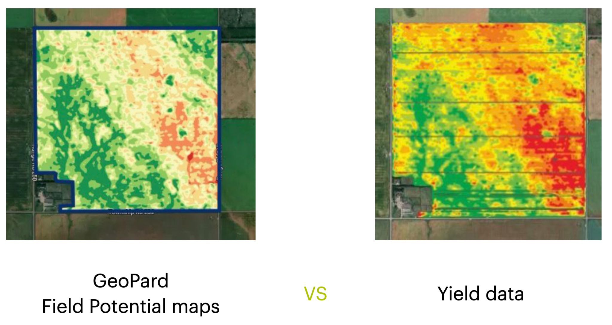
GeoPard Field Potential maps vs Yield data

GeoPard Field Potential maps very often look exactly like yield data.

We create them using multi-layer analytics of historical information, topography, and bare soil analysis.

The process of such synthetic Yield maps is automated (and patented) and it takes about 1 minute for any field in the world to generate it.


GeoPard Field Potential maps vs Yield data

Can be used as the basis for:

What are Field Potential maps?

Field potential maps, also known as yield potential maps or productivity potential maps, are visual representations of the spatial variability in potential crop yield or productivity within a field. These maps are created by analyzing various factors that influence crop growth, such as soil properties, topography, and historical yield data.

These maps can be used in precision agriculture to guide management decisions, such as variable-rate application of fertilizers, irrigation, and other inputs, as well as to identify areas that require specific attention or management practices.

Some key factors that are typically considered when creating field potential maps include:

  1. Soil properties: Soil characteristics such as texture, structure, organic matter content, and nutrient availability play a significant role in determining crop yield potential. By mapping soil properties across a field, farmers can identify areas of high or low productivity potential.
  2. Topography: Factors like elevation, slope, and aspect can influence crop growth and yield potential. For example, low-lying areas may be prone to waterlogging or have a higher risk of frost, while steep slopes may be more susceptible to erosion. Mapping these topographical features can help farmers understand how they affect productivity potential and adjust their management practices accordingly.
  3. Historical yield data: By analyzing historical yield data from previous years or seasons, farmers can identify trends and patterns in productivity across their fields. This information can be used to create these maps that highlight areas of consistently high or low yield potential.
  4. Remote sensing data: Satellite imagery, aerial photography, and other remote sensing data can be used to assess crop health, vigor, and growth stage. This information can be used to create these maps that reflect the spatial variability in crop productivity potential.
  5. Climate data: Climate variables such as temperature, precipitation, and solar radiation can also influence crop growth and yield potential. By incorporating climate data into these maps, farmers can better understand how environmental factors affect productivity potential in their fields.

They are valuable tools in precision agriculture, as they help farmers visualize the spatial variability in productivity potential within their fields. By using these maps to guide management decisions, farmers can optimize the use of resources, improve overall crop yields, and reduce the environmental impact of their agricultural operations.

Difference between Field Potential maps vs Yield data

Field potential maps and yield data are both used in precision agriculture to help farmers understand the spatial variability in their fields and make better-informed management decisions. However, there are some key differences between the two:

Data sources:

These maps are created by integrating data from various sources, such as soil properties, topography, historical yield data, remote sensing data, and climate data. However, this data is collected using yield monitors installed on harvesting equipment, which record the crop yield as it is harvested.

Temporal aspect:

These maps represent an estimation of the potential productivity of a field, which is generally static or changes slowly over time, barring significant changes in soil properties or other influencing factors. However, yield data is specific to a particular growing season or multiple seasons and can vary significantly from year to year based on factors like weather conditions, pest pressure, and management practices.

In summary, field potential maps and yield data are complementary tools in precision agriculture. These maps provide an estimate of the potential productivity of a field, helping farmers identify areas that may require different management practices. Yield data, on the other hand, documents the actual crop output and can be used to assess the effectiveness of management practices and inform future decision-making.

To compare field potential zones with the harvest they produced, open the Automated Yield Report: it puts yield next to the zones map, shows each zone against the field average, and prices every rate step.

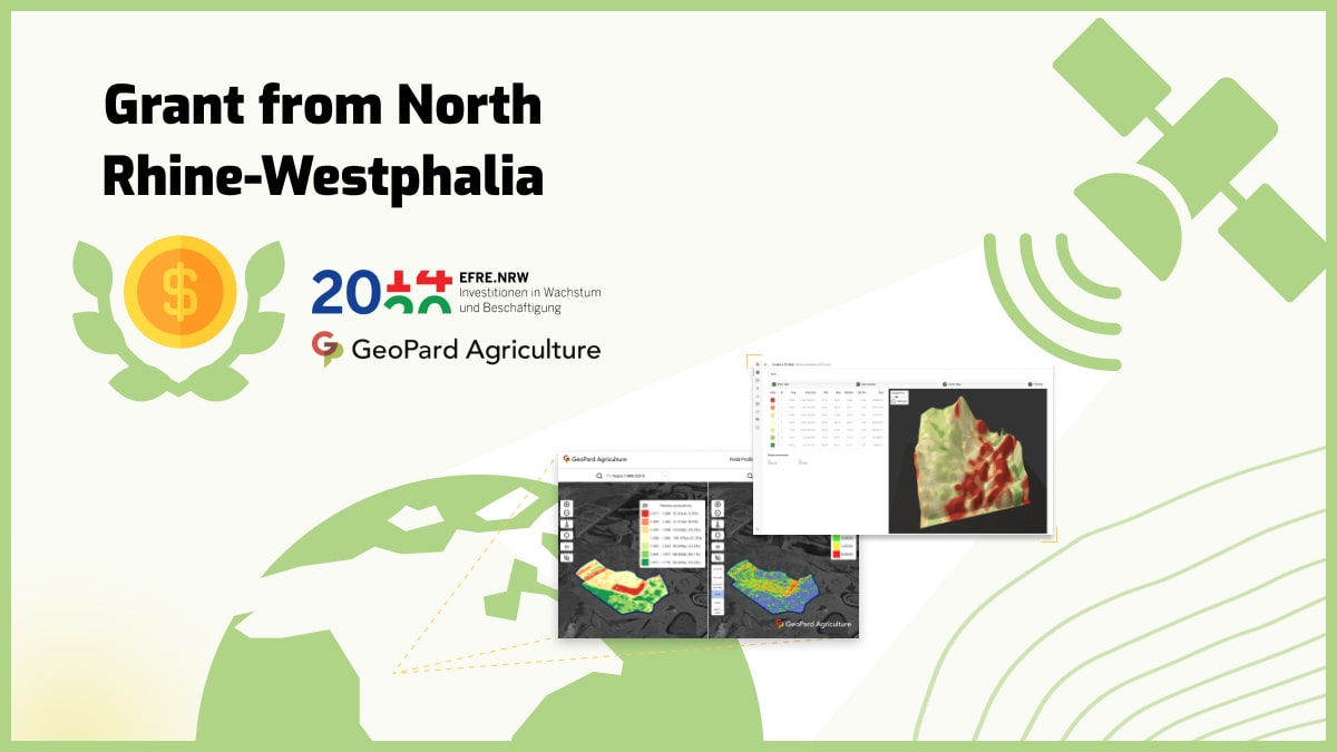
5G network in Agriculture. Grant from the state of North Rhine-Westphalia.

We are glad to announce that the “5G networks as an enabler for real-time learning in sustainable farming” project was selected for partial funding by the Ministry of Economic Affairs, Industry, Climate Action and Energy of the State of North Rhine-Westphalia.


Ministry of Economic Affairs, Industry, Climate Action and Energy of the State of North Rhine-Westphalia.

The project is researching how 5G can be used to make the agricultural process more ecological, economical and sustainable. The low latency of 5G makes it possible to integrate information technology systems into the process in real time and to react to sensor and position data within defined response times.

Together with our partner HSHL and the associated partner Pfeifer & Langen, the process of sugar beet cultivation from initial planting to harvesting is being examined on the partner’s fields to show how 5G can act as an enabler technology in the agricultural sector of NRW.


Project kick-off meeting on the field with representatives of Hochschule Hamm-Lippstadt, FlyPard Analytics GmbH and Pfeifer & Langen GmbH & Co. KG.

Project kick-off meeting on the field with representatives of Hochschule Hamm-Lippstadt, FlyPard Analytics GmbH and Pfeifer & Langen GmbH & Co. KG.

Role of 5G Network in Agriculture

5G networks, characterized by improved connectivity, reduced latency, and high-speed data transmission, possess the potential to substantially impact the agricultural industry. This state-of-the-art technology can accommodate various applications and innovations in agriculture, resulting in heightened efficiency, sustainability, and productivity. The following are some primary functions of 5G networks in agriculture:

  • Precision agriculture: 5G connectivity allows for real-time data acquisition, processing, and analysis from multiple sensors and devices, such as soil moisture sensors, weather monitoring stations, and drones. This empowers farmers to make data-informed decisions and implement precision agriculture practices, including targeted irrigation, fertilization, and pest management.
  • Remote monitoring and control: The reduced latency and high-speed data transfer capabilities of 5G networks enable real-time remote supervision and control of farming equipment and machinery. This leads to more effective resource allocation, lowered labor costs, and enhanced safety.
  • Autonomous farming: 5G networks facilitate the deployment of autonomous farming equipment, including self-driving tractors, harvesters, and drones. High-speed connectivity and low latency allow these machines to communicate with each other and make real-time adjustments, improving efficiency and minimizing human intervention.
  • Smart livestock management: 5G connectivity supports the use of IoT devices, such as smart collars and wearables, to monitor livestock health, location, and behavior in real-time. This helps farmers optimize feeding, breeding, and healthcare strategies, improving animal welfare and productivity.
  • Supply chain traceability: 5G networks can aid in the implementation of blockchain technology and IoT devices to monitor and track agricultural products throughout the supply chain. This improves traceability, strengthens food safety, and reduces waste.
  • Enhanced rural connectivity: 5G networks can help bridge the digital divide by providing high-speed internet access to rural and remote areas. This allows farmers to access online resources, tools, and services, fostering knowledge sharing, capacity building, and market access.
  • Virtual and augmented reality: 5G network can support the use of virtual and augmented reality applications in agriculture, such as remote training, equipment maintenance, and crop monitoring. This assists farmers in acquiring new skills, enhancing decision-making, and increasing efficiency.

In summary, 5G networks can play a vital role in modernizing and transforming the agricultural sector by enabling a wide array of applications and innovations. High-speed connectivity, reduced latency, and enhanced capacity of 5G can support the adoption of advanced technologies, resulting in increased productivity, sustainability, and overall growth in the industry.

GeoPard successfully passed the RootCamp accelerator program

About 300 companies applied for participation in the intense three-month Acceleration Program by RootCamp. But only 7 of them have been chosen as international AgriTech startups to join.

One of them is an agriculture intelligence platform based in Cologne, Germany called GeoPard. In short, GeoPard helps to automate the agronomic workflows like season planning, to fertilize, seeding, harvesting, and so on by streamlining them all in one system.

To do so, GeoPard uses cutting-edge spatial data analytics and AI algorithms and focuses on making sustainable and profitable precision agriculture solutions accessible and affordable to all agribusinesses.

Data products provided by GeoPard include soil sampling analytics, crop monitoring, field benchmarking, and Variable Rate application maps for agricultural in-season operations (like seeding, fertilizing, crop protection, and herbicides).

Some Unique Data Products of GeoPard Presented in Rootcamp

GeoPard focuses on building a Digital Twin of any agricultural field by aggregating all available data layers obtained through various methods and technologies. Moreover, some of the salient advantages that make GeoPard stand out from a crowd of similar products include:

1. An attractive business model for all business sizes: GeoPard users only pay for consumed analytics with no extra costs. GeoPard offers several plans to choose from according to the customer’s size.

The pricing model is based on an AWS-like pay-as-you-go credits approach that ensures that our offer remains affordable for all sizes of agricultural businesses. GeoPard also boasts a service that ensures delivery of the branded precision agriculture solution in just 2 weeks.

2. Independence and non-biasedness: About 0.5M data points are generated per day per farm as of 2021 and this number will be x6 during the next 10 years.

As data becomes more and more valuable, their security and protection become equally important, especially while dealing with massive data like this. So it is noteworthy that GeoPard is not affiliated with any agricultural corporation and all the data is owned by the user and is definitely not for sale.

3. Level of automation and analytics capabilities: The whole point of precision agriculture is to optimize the usage of agricultural inputs and maximize yield via data-driven decisions.

Efficiently dealing with such a huge amount of data requires increasing automation and decreasing manual work. GeoPard achieves this by establishing a platform that automatically collects data layers, standardizes them, and streamlines agricultural field insights on top.

So GeoPard customers focus on efficient data-driven decisions instead of struggling with manual data processing.

Another highlight of GeoPard is its user-friendly web and mobile interfaces. Along with the web and mobile interfaces, GeoPard provides integration capabilities like API, widgets, White Label, and On-premise solutions.

GeoPard also provides a quick assistance service that can help customers anytime. Ongoing communication with the customers and partners, consultants, and business is of prime importance in both the past and future of this company.

GeoPard aims to improve the adoption of precision farming technologies, ensure efficient and sustainable crop production, and offer high-quality and adaptable data products.

The overall operation of GeoPard in the field of sustainable precision agriculture is based on using the most sophisticated technologies for data capturing, streamlining of analytics, and dissemination while ensuring that customers have the most practical experience and the highest ROI using data products from GeoPard.

Having specialized in precision farming technologies to maximize the efficiency of all agribusinesses, GeoPard plans to venture more into data products for sustainability, biodiversity, and carbon sequestration in the future.

To dive deeper into GeoPard, its services, its vision, and its plan for the future from one of the founders, you can watch this video or read more on this blog.

GeoPard solution passed AWS certification

In February 2022 GeoPard* joined AWS Partner Network** as a Technology Partner. The community of AWS Partners includes strategic experts and experienced cloud engineers and architects, who help address specific business needs and build cost-effective scalable cloud solutions for organizations. Here the GeoPard team brings its 10+ years of experience in building cloud scalable digital solutions in Agriculture and ​​assists crop farming agribusinesses to keep pace with cloud cutting-edge technology.

AWS Partner

In March 2022 GeoPard platform successfully passed the Foundational Technical Review performed by AWS Solution Architects. The review included certifications according to the Center for Internet Security (CIS v1.2.0) and AWS Foundational Security Best Practices (v1.0.0).

In other words, the GeoPard Agriculture platform met AWS security and best practice requirements. And it is ready for On-premise/White Label installation in the customer AWS cloud.

AWS certification partner

GeoPard took additional steps to extend its market offer with certified on-premise solutions to be utilized either as a standalone data platform or as an automated data analytics extension to already existing digital farming suites. That makes integration to the customer’s cloud infrastructure faster and smoother.

* GeoPard is an agriculture intelligence platform that enables crop farming agribusinesses to increase ROI via data-driven agronomic decisions and integrate sustainable precision agriculture practices using cutting-edge spatial data analytics and AI algorithms.
AWS Startups Blog: Improving the Sustainability of Crop Farming Using a Data-driven Approach.

** The AWS Partner Network (APN) is a global community of partners that leverages programs, expertise, and resources to build, market, and sell customer offerings.

GeoPard and Origin Digital partnership to provide precision farming solutions

The GeoPard agriculture and Origin digital company have entered into an alliance deal to unravel problems relating to farming.

The motive behind the alliance is to expand the agricultural market sphere with digital and data-driven methods such as precision agriculture, data analysis, and software development.

They also offer professional programs and suggestions to clients on how to choose viable seeds, the science of planting and harvesting crops, and soil sampling methods.

Many of these innovations are now obtainable in Ukraine since it’s the base of the companies. The Origin Digital company has incorporated farming consultancy, good farming strategies, and data-based methods to ease the process of making decisions.

Additionally, the program helps experts to drive through precision farming easily. The central focus of the allied groups is to look into the problems of farmers and proffer practical solutions.

The Chief Executive officer of Geopard Agriculture, Mr. Dmitry Dementiev mentioned in one of his statements:

“The Geopard’s team affiliation with Origin digitals is a milestone for the advancement of precision farming. Clients can now access digital remedies provided by the company easier and faster due to the alliance.”

He also added that his team is delighted with the recent development and they are ready to make things work out well.

The Head of Origin Digital Company, Mr. Jon Rhymes also said: “The alliance will promote precision farming in Ukraine. This is because the companies have incorporated programs such as data analysis and artificial intelligence in their scheme. These programs will ease the manner of disseminating information and making suggestions to prospective clients.”

Similarly, the crop growers in Ukraine will benefit from the program. It will also assist them to cut down production costs, increase their gains and guide them through the other processes.

What are precision farming solutions?

Precision farming solutions are technologies and techniques used to optimize crop production through data-driven decision-making and targeted input application. Some examples of precision farming solutions include:

  1. Variable-rate technology (VRT): This technology enables farmers to apply inputs such as fertilizers, pesticides, and seeds at varying rates across a field, based on factors such as soil fertility, crop growth stage, and yield potential.
  2. Remote sensing: This includes the use of satellites, drones, and other sensors to collect data on soil and crop conditions, which can be used to make informed decisions about input application and crop management.
  3. Geographic Information System (GIS): GIS is a tool that enables farmers to collect, store, analyze, and manage spatial data about their fields, such as soil type, elevation, and weather patterns.
  4. Precision irrigation: This includes technologies such as drip irrigation and soil moisture sensors, which enable farmers to optimize water use and reduce waste.
  5. Autonomous equipment: Autonomous tractors and other equipment can be programmed to perform tasks such as planting, fertilizing, and harvesting, allowing for greater precision and efficiency in crop management.

Overall, precision farming solutions enable farmers to make data-driven decisions that optimize crop yields, reduce input waste, and improve overall efficiency. By leveraging advanced technologies and techniques, precision farming solutions can help farmers meet the challenges of a rapidly changing agricultural landscape and achieve sustainable, profitable crop production.

GeoPard showcased at FoodHub NRW expo

Last week GeoPard team presented at the Foodhub NRW expo in Neuss, Germany.

Our speaker session was about the state of Precision Agriculture, past, present, and the future.
In detail, we described a few examples of how decision support tools and data analysis helps to implement data-driven crop farming practices in different regions: the US, Canada, Europe.

GeoPard team presented at the Foodhub NRW expo in Neuss, Germany

We are proud to be in the epicenter of innovations in the crop farming industry.

It was great to meet a lot of food startups. Agriculture is one of the biggest industries in the world and we need more innovations and collaborations between corporates and startups across the value chain.


wpChatIcon
wpChatIcon

    Request Free GeoPard Demo / Consultation


    By clicking the button you agree our Privacy Policy. We need it to reply to your request.

      Subscribe


      By clicking the button you agree our Privacy Policy

        Send us information


        By clicking the button you agree our Privacy Policy