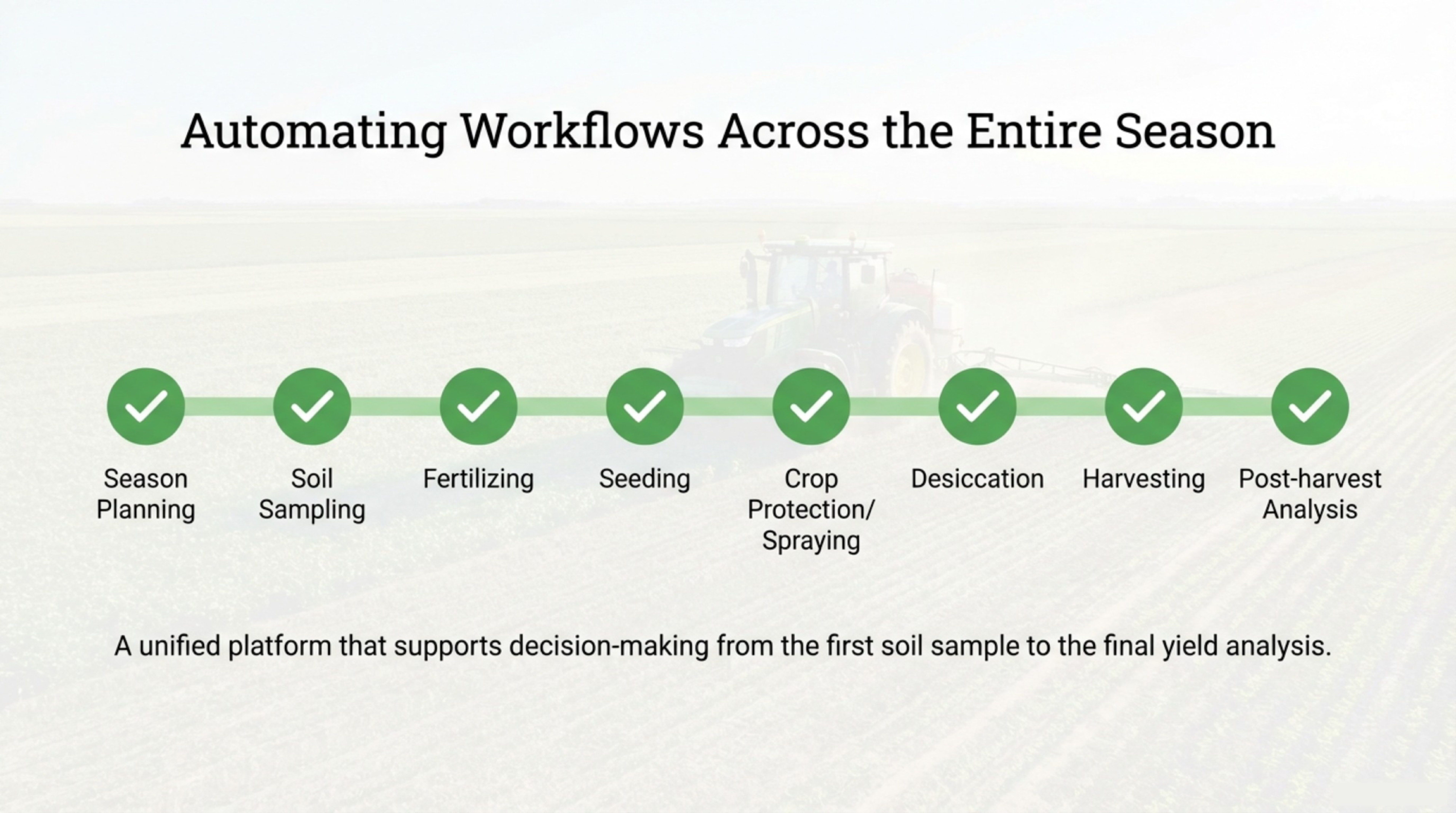
Preparing for Q2 Success: Essential Steps from Q1 Precision Insights
You’ve spent months gathering Q1 insights from your fields, but turning that data into a clear Q2 plan can feel overwhelming. GeoPard Agriculture simplifies this by unifying your yield data analytics, soil layers, and satellite imagery into actionable steps. In this post, you’ll learn how to use management zones and variable rate application tools to sharpen your Q2 planning and connect seamlessly with John Deere Operations Center. For more insights on precision agriculture, check out this resource.
Leveraging Q1 Insights for Q2 Planning

As you step into Q2, it’s crucial to make the most of your Q1 data. Transforming these insights into actionable strategies can set the stage for success.
Analyzing Yield Data and Soil Layers
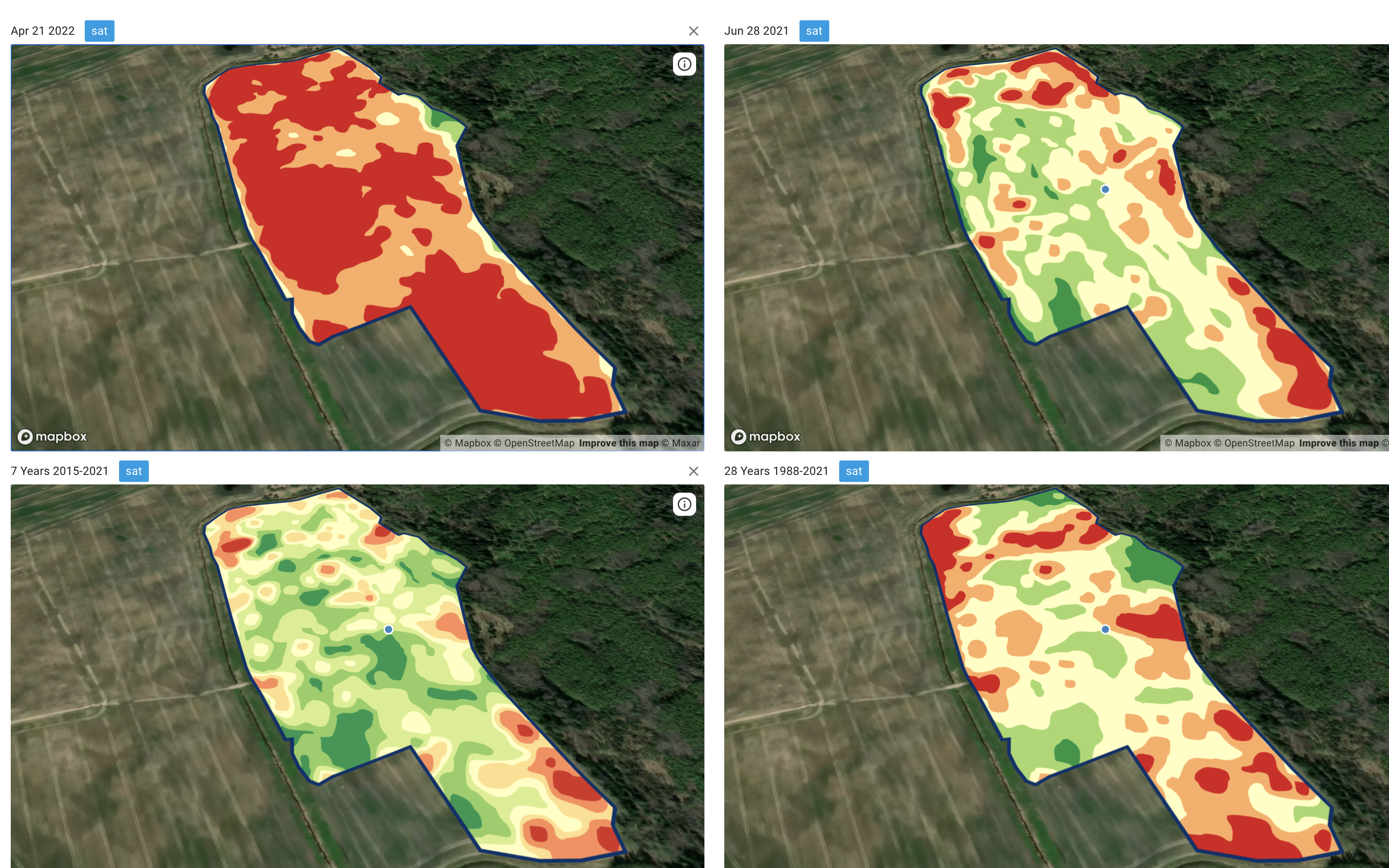
Uncovering trends within your yield data is the first step. This data, along with detailed soil layers, reveals the unique characteristics of your fields. By examining patterns, you can pinpoint which areas consistently perform well and which require attention. For example, a field that shows a 15% increase in yield might indicate optimal soil conditions.
Next, integrate soil data to understand its impact on crop performance. This might include analyzing pH levels or nutrient content. By doing so, you can identify specific areas needing nutrient adjustments. Imagine knowing exactly where to apply fertilizers for maximum impact. This precision not only saves resources but also enhances overall yield.
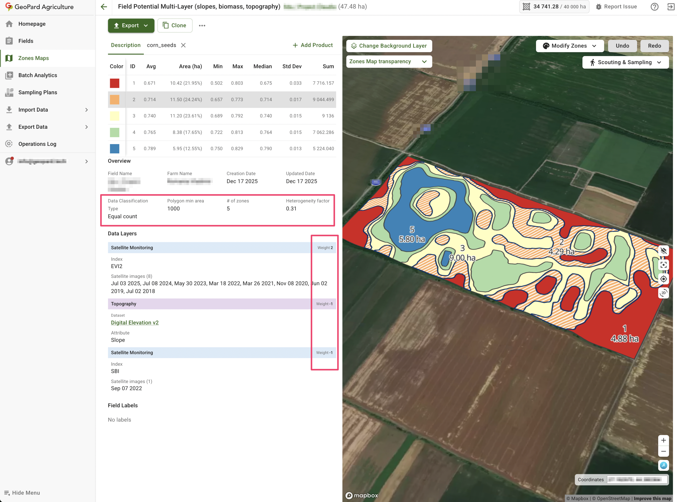
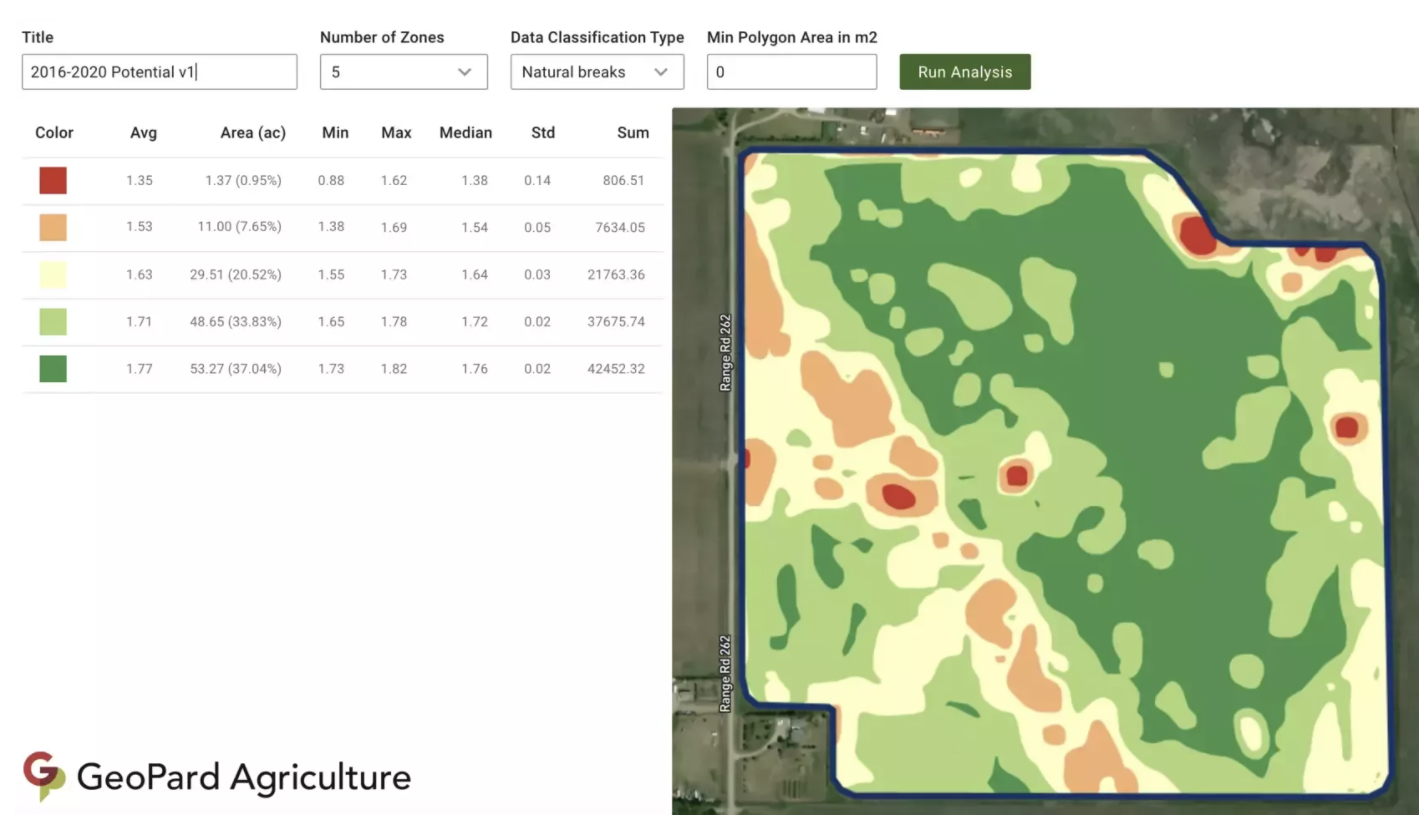
Mapping Management Zones and VRA Maps
Creating management zones allows for tailored strategies in each area. When you’re aware of field variability, you can address each zone’s needs specifically. For instance, a high-yield zone might require less intervention, while a low-yield area could benefit from targeted inputs.
Variable Rate Application (VRA) maps are your allies in this process. They guide you in applying the right amount of resources where needed. This approach not only optimizes input use but also increases profitability. Crafting these maps might seem challenging, but with the right tools, it becomes a straightforward task.
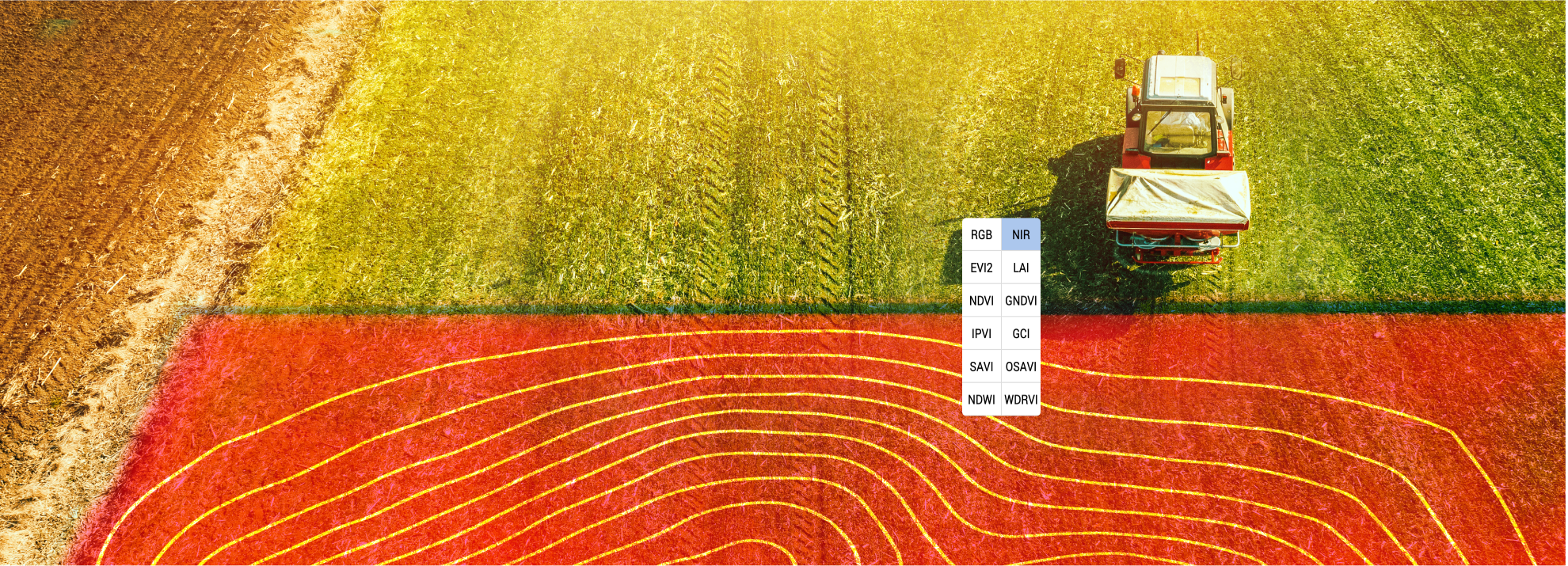
Harnessing NDVI and Satellite Imagery
NDVI and satellite imagery provide a bird’s eye view of your fields. These tools reveal crop health and growth patterns in real-time. By regularly monitoring this imagery, you can react swiftly to any changes. This insight allows for proactive management, addressing issues before they escalate.
Imagine spotting a pest outbreak early through satellite imagery. You can intervene immediately, safeguarding your crops. This proactive management ensures healthier fields and better yields. Leveraging these tools places you ahead, ensuring your crops thrive throughout the season.
GeoPard Tools for Q2 Success

GeoPard’s suite of tools empowers you to implement these strategies seamlessly. These tools are designed to enhance your decision-making and streamline operations.
Streamlining John Deere Operations Center Integration
Integrating with the John Deere Operations Center brings a new level of efficiency. It allows for seamless data flow between your systems. This integration means less manual entry and more time focusing on strategy. Data syncing ensures that your decisions are backed by the latest insights.
By connecting your GeoPard data with John Deere, you’re ensuring consistency across platforms. This unified approach simplifies your workflow, reducing the chances of errors. It’s about creating a system where every decision is data-driven and precise.
Crafting Smart Recommendations and Agronomic Workflows
Crafting smart recommendations is about understanding the nuances of your fields. GeoPard enables you to create agronomic workflows tailored to each zone’s needs. This customization ensures that every action you take is optimized for results.
Whether it’s adjusting fertilizer rates or planning irrigation schedules, these workflows guide you. They provide a clear path to follow, ensuring you’re always on track. Ultimately, it’s about maximizing your field’s potential with informed decisions.
Monitoring Crops with Historical Imagery
Historical imagery offers a wealth of information. It allows you to track changes and trends over time. By analyzing this data, you can predict future challenges and opportunities. This foresight helps in planning and resource allocation.
Imagine knowing exactly how a field responds to certain treatments over the years. This knowledge makes future planning more effective. You’re not just reacting to changes; you’re anticipating them, ensuring your fields remain productive.
Driving Trials and Demos with Precision

Precision is key when it comes to trials and demos. It’s about showcasing the effectiveness of your strategies and tools.
Implementing Bi-Directional Data Sync
Bi-directional data sync ensures that information flows seamlessly between systems. This feature keeps your data current and consistent. It’s crucial for making real-time decisions during trials.
By maintaining data accuracy, you can trust the results of your trials. This reliability builds confidence in your strategies and showcases their effectiveness. Stakeholders can see the real impact of data-driven decisions.
Conducting ROI Analysis and Profitability Mapping
ROI analysis is essential for understanding the financial impact of your strategies. With GeoPard, you can map profitability across different zones. This analysis highlights which areas deliver the best returns.
Profitability mapping guides your investment decisions. It shows where to focus resources for maximum gain. With clear insights, you can make informed financial decisions that enhance overall profitability.
Engaging with Free Trials and Subscriptions
Free trials and subscriptions offer a low-risk way to explore GeoPard’s capabilities. They provide hands-on experience with the tools and features. This engagement helps you see firsthand how GeoPard can transform your operations.
By trying these tools, you gain confidence in their benefits. It’s about understanding how GeoPard fits into your workflow and enhances decision-making. Embrace these opportunities to fully realize the potential of precision agriculture.
By leveraging these insights and tools, you’re not just planning for Q2; you’re setting the foundation for ongoing success.
Prepare for smarter farm decisions this year