How Advanced Analytics Helped Agribusinesses Overcome Q1 Hurdles: A Strategic Guide

How Advanced Analytics Helped Agribusinesses Overcome Q1 Hurdles: A Strategic Guide

Q1 throws a mix of weather swings, tight planting timelines, and rising input costs at agribusinesses every year. You’ve likely felt the pressure of these challenges cutting into your margins and decision-making. With advanced analytics for agribusiness, you can turn complex data into clear, actionable steps—like creating precise management zones and variable rate application maps—that keep your operations on track. Let’s explore how GeoPard’s AI-driven platform helped farms overcome these hurdles and deliver measurable ROI this season. For more insights, check out this document.

Navigating Q1 Agribusiness Challenges

Weather, prices, and planting windows create a perfect storm in Q1 for agribusinesses. Let’s see how you can navigate these challenges effectively.

Managing Weather Volatility with Precision

Weather unpredictability is a major concern for farmers. But what if you could forecast accurately and prepare better? GeoPard’s platform helps you use historical data and satellite imagery to understand weather patterns. This data lets you plan operations when conditions are just right.

For instance, using NDVI time series, you can track plant health and predict growth stages. This means you can optimize your crop management around expected weather changes, ensuring your crops thrive regardless of what Mother Nature throws your way.

Tackling Input Price Fluctuations

Why pay more when you can save smartly? Rising input costs can eat into profits, but smart planning makes a difference. GeoPard’s software analyzes your field data to recommend precise input levels. This means you use only what you need, cutting unnecessary costs.

Imagine reducing fertilizer use by 20% while maintaining yield. By understanding yield and soil data integration, you’re not just guessing; you’re making data-backed decisions that result in savings.

Addressing Tight Planting Windows

Timing is everything in planting. Miss the window, and yields suffer. GeoPard’s crop monitoring platform keeps you informed about optimal planting times. With real-time data, you can seize the perfect moment.

Think of it this way: instead of rushing, you’re strategizing. Precise timing means healthier crops and better yields, putting you ahead in Q1.

Leveraging Precision Agriculture Software

Precision agriculture software transforms farming challenges into opportunities. Here’s how GeoPard leads the way with its advanced tools.

GeoPard for Advanced Analytics

Why settle for guesswork when you can have precision? GeoPard offers advanced analytics for agribusiness, turning complex data into clear solutions. With over 20 years of satellite imagery, you gain a historical edge in planning.

This software doesn’t just provide data; it offers insights. By integrating topography analytics, you understand your land better, making informed decisions that boost productivity.

Smart Agronomic Recommendations

What if your software could think like an agronomist? GeoPard offers smart agronomic recommendations based on real-time data. The recommendations adapt to your specific fields, ensuring optimal input use and timing.

This means you’re not just managing your fields; you’re mastering them. With precise recommendations, you enhance productivity and reduce waste.

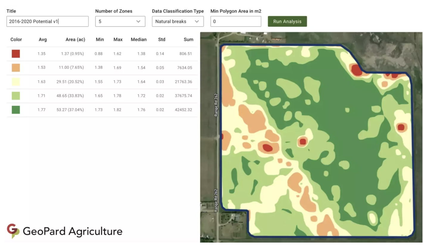
Creating Management Zones and VRA Maps

Imagine knowing exactly where to plant, fertilize, or irrigate. GeoPard’s tools allow you to create management zones and variable rate application maps tailored to your fields. These maps ensure every input is used effectively.

Instead of a one-size-fits-all approach, you have a customized strategy that reflects your unique landscape, leading to better resource management and higher yields.

Realizing ROI with Data-Driven Agronomy

Data is power, especially in agriculture. Let’s explore how you turn data into profit with GeoPard.

Crop Monitoring and Decision Support

Picture having a personal assistant for your fields. GeoPard’s crop monitoring platform offers in-season decision support, keeping you updated on crop health and growth. This proactive monitoring means fewer surprises and more informed decisions.

By spotting issues early, you save on potential losses, turning challenges into opportunities for improvement.

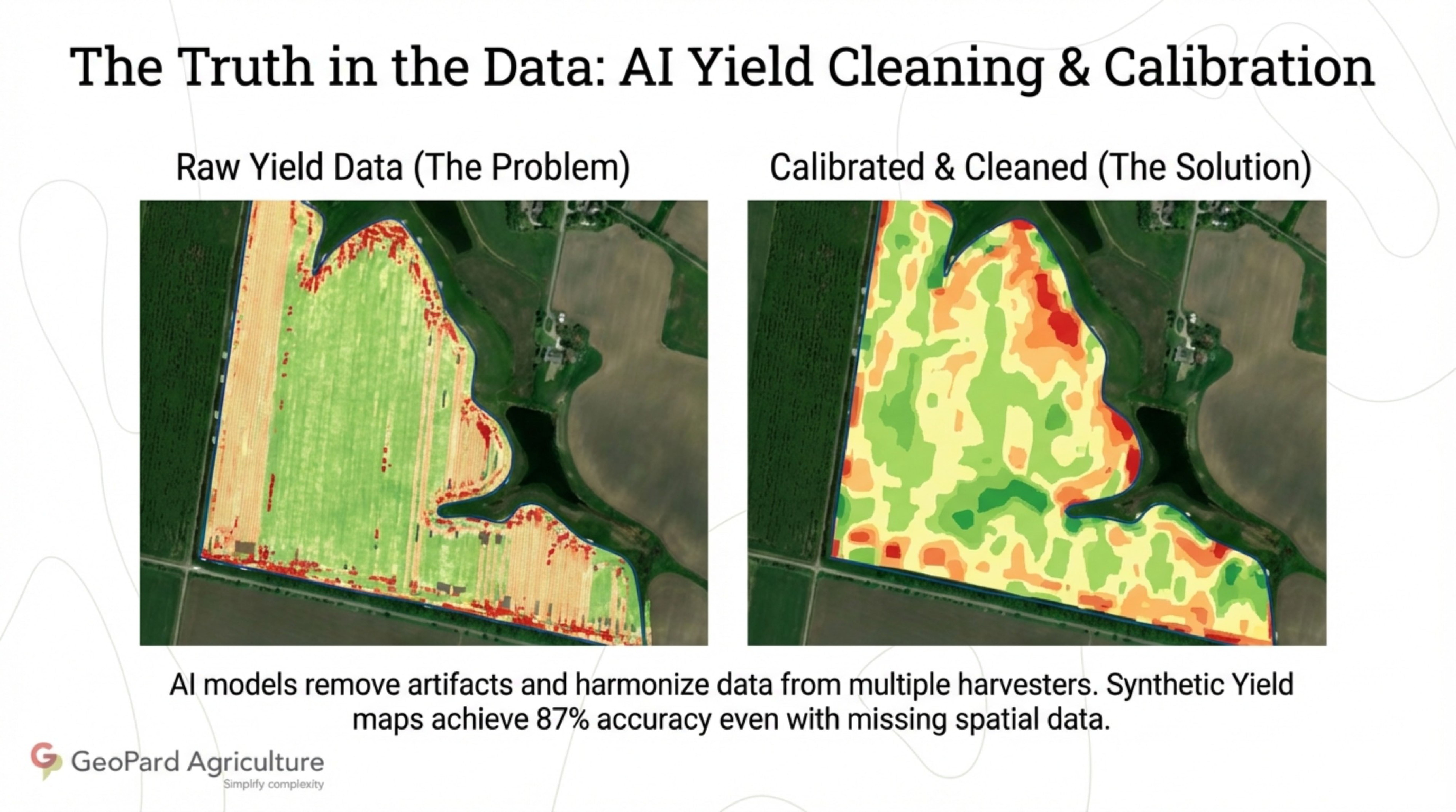
Integrating Yield and Soil Data

Your soil tells a story. By integrating yield and soil data, you understand your fields better. GeoPard’s platform helps you combine these data points to enhance decision-making, ensuring every action is guided by facts.

This integration means better planning, optimized input use, and ultimately, higher returns on your investment.

John Deere Operations Center Bi-Directional Sync

In the fast-paced world of farming, flexibility is key. GeoPard’s integration with John Deere Operations Center provides bi-directional data sync, ensuring your data flows smoothly between platforms. This seamless integration means your operations are always up-to-date.

By syncing data, you streamline processes, reduce errors, and enhance efficiency, leading to a higher ROI. This approach not only saves time but also positions you for success in agribusiness.

Prepare for smarter farm decisions this year

Streamlining Farm Data Workflows: Q1 insights and actionable tips for ag service providers

Streamlining Farm Data Workflows: Q1 Insights and Actionable Tips for Ag Service Providers

You just spent hours juggling fragmented data across multiple platforms and still can’t get a clear picture of your fields. Farm data workflows often slow down agronomists and service providers more than they realize. In this post, you’ll find Q1 insights revealing common bottlenecks and practical tips to streamline your data ingestion, analysis, and delivery using GeoPard’s precision agriculture software. Learn more here.

Key Q1 Farm Data Insights

Understanding Q1 farm data insights can illuminate significant challenges and solutions for agronomists. Let’s explore common workflow issues and how GeoPard makes a difference.

Common Data Workflow Bottlenecks

Agricultural data often sits in silos, leading to delays. Imagine trying to merge data from multiple sources manually. This can take hours. Many service providers report that over 50% of their time gets lost in data wrangling. The complexity of handling different formats is another hurdle. Most people think that having large amounts of data is beneficial, but it can overwhelm if not managed well.

GeoPard’s Role in Streamlining

GeoPard’s software simplifies these workflows, making data more accessible. By consolidating information from various sources, it reduces processing time significantly. With GeoPard, you can integrate and analyze data in real-time. This approach challenges the belief that data management has to be cumbersome. Instead, it’s about efficiency and clarity.

Streamlining Data Processes

Improving how you handle farm data can transform your agricultural operations. Let’s see how you can optimize each stage, from ingestion to delivery.

Ingesting Agricultural Data Efficiently

The first step is gathering data effectively. GeoPard supports multiple data types, including soil sensors and satellite imagery. This integration enables a seamless collection process. For instance, using automated data entry, you can reduce errors and save time. Many think manual entry is unavoidable, but automation proves otherwise.

Analyzing with Precision Agriculture Software

Once you’ve collected data, analysis becomes crucial. GeoPard’s precision software uses AI to provide deep insights. You can generate management zones and variable rate application maps. This means you can make informed decisions faster. A key insight: precise data analysis leads to better crop management.

Delivering Insights to Ag Service Providers

Finally, delivering insights efficiently is vital. GeoPard ensures that service providers receive timely reports. This includes yield data analysis and topography analytics. By sharing clear insights, you help clients optimize their operations. The longer you wait to streamline, the more opportunities you miss.

Actionable Tips for Service Providers

Enhance your service offerings with practical steps. These tips will help you harness GeoPard’s capabilities effectively.

Implementing a Practical Checklist

Creating a checklist can guide your workflow improvements. Start with assessing your current data sources. Then, identify integration opportunities with platforms like GeoPard. Regularly reviewing this checklist ensures continuous improvement. Here’s the key insight: structured processes lead to better outcomes.

Engaging with GeoPard’s Free Trial

Trying out GeoPard’s trial can demonstrate its potential. During the trial, explore features like AI agronomy analytics and field analytics platforms. This hands-on experience can show you how it fits into your workflow. Most people hesitate to try new software, but trials offer risk-free exploration.

Integration with John Deere Operations Center

GeoPard integrates seamlessly with systems like the John Deere Operations Center. This bi-directional data sync enhances collaboration. By using such integrations, you can streamline operations further. It challenges the idea that systems must remain isolated. Instead, interconnected platforms offer greater value.

In conclusion, streamlining your farm data workflows with GeoPard can lead to significant operational improvements. From ingestion to delivery, each step offers opportunities for optimization. Adopting these practices will not only improve efficiency but also enhance your service offerings.

Prepare for smarter farm decisions this year

How Integrated Farm Data Analytics Elevate Agronomic Decisions

How Integrated Farm Data Analytics Elevate Agronomic Decisions

You spend hours juggling soil tests, yield maps, satellite images, and machine data—yet your agronomic decisions still feel like guesses. Integrating farm data into one platform changes everything. With GeoPard Agriculture, you get AI powered analytics that turn scattered information into clear management zones and precise VRA maps. Keep reading to see how this unified approach sharpens your agronomic decision making and boosts your ROI. https://www.morningagclips.com/agriculture-data-analytics/

The Power of Integrated Farm Data

Harnessing the full spectrum of farm data can transform your approach to agriculture. Let’s dive into how combining different data types can improve decision-making on the farm.

Yield Data Analysis Insights

Understanding your yield data is crucial. It tells the story of your farm’s productivity. With detailed analysis, you can spot patterns and identify areas for improvement. Imagine knowing exactly which parts of your field yield best. This is the power of using analytics to break down your yield data. You can boost output where it’s needed most and reduce input where it’s not. By focusing on yield data, you can make informed decisions that directly impact your bottom line.

Soil Test Mapping Techniques

Soil is the foundation of any farm. Knowing its composition and health is vital. Soil test mapping lets you visualize nutrient levels across your fields. This helps in applying the right amount of fertilizer in the right places. By mapping soil quality, you can avoid wasting resources on areas that don’t need them. This precision saves money and supports healthier crops.

Topography and Satellite Imagery Analytics

The lay of the land affects water flow and nutrient distribution. Topography analytics provide insights into these factors. Coupled with satellite imagery, you get a bird’s-eye view of your fields. Satellite data shows changes over time, revealing trends not visible at ground level. This information helps in planning irrigation and preventing erosion, enhancing farm efficiency.

Enhancing Agronomic Decision Making

When you integrate various data sources, your agronomic decisions become more strategic. Let’s explore how this integration can refine your farming practices.

Creating Stable Management Zones

Stable management zones are the key to efficient farming. These zones are areas within a field that respond similarly to management practices. By establishing these zones, you can tailor your approach to each one. This means applying inputs like water and fertilizer more accurately. Stable zones lead to consistent results, reducing guesswork and enhancing productivity.

Variable Rate Application Maps Explained

Variable Rate Application (VRA) maps are a game-changer. They allow you to apply inputs such as seeds and fertilizers precisely where needed. VRA maps are created using data from soil tests, yield data, and topography. This precision ensures that each part of your field gets exactly what it needs. The result is less waste and better crop performance.

Benefits of AI Powered Analytics

AI transforms raw data into actionable insights. With AI, you can process complex datasets quickly and accurately. This technology identifies trends and anomalies you might miss. By leveraging AI, you optimize every decision, from planting to harvesting. The longer you wait to adopt AI, the more opportunities you miss to improve efficiency and boost ROI.

GeoPard Agriculture: Your Agtech Solution

GeoPard Agriculture offers a comprehensive platform that unifies all these capabilities. Let’s see how it supports your farming operations.

John Deere Operations Center Integration

GeoPard integrates seamlessly with John Deere Operations Center, enhancing your existing system. This integration allows for easy data flow between platforms. Your machinery data combines with GeoPard’s analytics for a complete picture of your farm’s performance. This synergy streamlines operations and improves decision-making.

ROI Analysis in Agriculture

Understanding your return on investment is crucial. GeoPard provides tools to analyze ROI across different farm operations. By examining inputs and outputs, you can identify areas to cut costs and maximize profits. This analysis is essential for long-term farm sustainability.

Start Your Free Trial Today

GeoPard Agriculture empowers you to make data-driven decisions with confidence. Unlock the potential of your fields by trying GeoPard today. With access to advanced analytics and integration capabilities, you streamline your farming operations and elevate your agronomic decision-making. Don’t wait—start your free trial now and take the first step towards precision agriculture.

Identify your biggest precision agriculture challenges and start building solutions.

wpChatIcon
wpChatIcon

    Request Free GeoPard Demo / Consultation


    By clicking the button you agree our Privacy Policy. We need it to reply to your request.

      Subscribe


      By clicking the button you agree our Privacy Policy

        Send us information


        By clicking the button you agree our Privacy Policy