How GeoPard Automation Cuts Manual Data Processing in Precision Agriculture

Manual data entry drains your time and invites costly errors in precision agriculture automation. GeoPard’s tools cut this burden by syncing your yield data, soil tests, and satellite imagery automatically. You’ll see how streamlined agronomic data integration speeds decisions and boosts ROI while reducing tedious tasks. Keep reading to learn how GeoPard transforms your precision ag workflow into a faster, smarter process.

Streamlining Precision Agriculture Workflows

Precision agriculture is evolving rapidly, and automation is at its core. Let’s explore how this shift benefits your farm’s efficiency.

Precision Agriculture Automation Benefits

Imagine a world where you spend less time on data entry and more on actual farming. Automation tools make this possible. They sync yield data, soil tests, and imagery without manual effort. This means fewer errors and faster decisions. By using tools like GeoPard, you reduce tedious tasks. Automation not only saves time but also boosts accuracy, giving you peace of mind.

Agronomic Data Integration Explained

Integrating agronomic data is crucial. Without it, making informed decisions is challenging. GeoPard brings your data together in one place. Think yield data, soil tests, and satellite imagery, all synced automatically. This integration speeds up decision-making and reduces errors. You can focus on what’s important: farming. By having all your data in a single platform, you streamline operations and enhance productivity. Discover more on how to streamline your farm data workflows.

ROI Analysis After Season

Once the season ends, evaluating your return on investment (ROI) is key. GeoPard’s tools help you assess this with precision. By analyzing data collected throughout the season, you can pinpoint areas of improvement. This insight allows for better planning in the next season. Understanding your ROI empowers you to make smarter financial decisions. The longer you wait to analyze, the more potential insights you might miss.

Key Features of GeoPard Automation Tools

GeoPard offers several features designed to optimize your farming operations. Let’s dive into the standout tools that set GeoPard apart.

Automated Management Zones

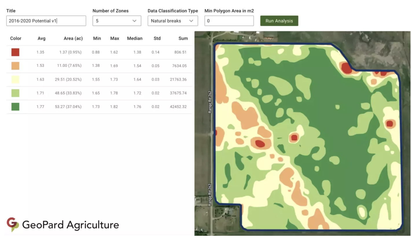
Creating management zones is now simpler than ever. GeoPard automates this process, using data like soil composition and crop performance. By doing so, you can apply the right resources to the right areas. This targeted approach maximizes effectiveness and minimizes waste. With automated zones, you have more control over your farm’s productivity.

Variable Rate Prescriptions and VRA Maps

Variable rate applications (VRA) are game-changers in precision farming. GeoPard provides tools to create VRA maps effortlessly. These maps let you apply inputs at varying rates based on field conditions. The outcome? Better resource utilization and healthier crops. VRA maps are compatible with most agricultural equipment, making integration smooth.

Bi-directional Data Sync with John Deere

Integrating with existing systems is crucial. GeoPard syncs bi-directionally with the John Deere Operations Center. This means seamless data flow between platforms. You gain access to high-quality data without manual input. This integration enhances decision-making and streamlines your operations. Check out more about GeoPard’s John Deere integration.

Enhancing Agronomic Decision-Making

Decision-making in agriculture is data-driven. GeoPard enhances this process with advanced tools and insights.

Yield Data Processing and Soil Test Analytics

Processing yield data can be a task, but with GeoPard, it’s straightforward. The platform analyzes yield data and soil tests to provide actionable insights. This analysis helps you understand crop performance and soil health better. With these insights, you can make informed decisions about planting and fertilization strategies. The result is improved crop yields and healthier soil.

Topography Modeling and Satellite Imagery

Understanding your land’s topography is vital. GeoPard uses satellite imagery to model your farm’s terrain accurately. This modeling helps you identify areas that require more attention or resources. With better topography understanding, you can optimize irrigation and reduce erosion risks. Satellite imagery offers a clear view of your fields, helping you plan more effectively.

AI Powered Agronomy and Crop Monitoring

AI is revolutionizing agronomy. GeoPard leverages AI to monitor crops and provide real-time insights. This technology predicts potential issues before they become problems. With AI-powered monitoring, you can react quickly to changes in your fields. It also helps in resource allocation, ensuring that your efforts are productive. Learn more from this GeoPard product tour.

By adopting GeoPard’s automation tools, you unlock a world of benefits. From reduced manual data entry to enhanced decision-making, the advantages are clear. Take the initiative to streamline your operations and boost your farm’s productivity today.

Explore automation and API solutions designed for scalable precision ag success.
Preparing for Q2 Success: Essential Steps from Q1 Precision Insights

Preparing for Q2 Success: Essential Steps from Q1 Precision Insights

You’ve spent months gathering Q1 insights from your fields, but turning that data into a clear Q2 plan can feel overwhelming. GeoPard Agriculture simplifies this by unifying your yield data analytics, soil layers, and satellite imagery into actionable steps. In this post, you’ll learn how to use management zones and variable rate application tools to sharpen your Q2 planning and connect seamlessly with John Deere Operations Center. For more insights on precision agriculture, check out this resource.

Leveraging Q1 Insights for Q2 Planning

As you step into Q2, it’s crucial to make the most of your Q1 data. Transforming these insights into actionable strategies can set the stage for success.

Analyzing Yield Data and Soil Layers

Uncovering trends within your yield data is the first step. This data, along with detailed soil layers, reveals the unique characteristics of your fields. By examining patterns, you can pinpoint which areas consistently perform well and which require attention. For example, a field that shows a 15% increase in yield might indicate optimal soil conditions.

Next, integrate soil data to understand its impact on crop performance. This might include analyzing pH levels or nutrient content. By doing so, you can identify specific areas needing nutrient adjustments. Imagine knowing exactly where to apply fertilizers for maximum impact. This precision not only saves resources but also enhances overall yield.

Mapping Management Zones and VRA Maps

Creating management zones allows for tailored strategies in each area. When you’re aware of field variability, you can address each zone’s needs specifically. For instance, a high-yield zone might require less intervention, while a low-yield area could benefit from targeted inputs.

Variable Rate Application (VRA) maps are your allies in this process. They guide you in applying the right amount of resources where needed. This approach not only optimizes input use but also increases profitability. Crafting these maps might seem challenging, but with the right tools, it becomes a straightforward task.

Harnessing NDVI and Satellite Imagery

NDVI and satellite imagery provide a bird’s eye view of your fields. These tools reveal crop health and growth patterns in real-time. By regularly monitoring this imagery, you can react swiftly to any changes. This insight allows for proactive management, addressing issues before they escalate.

Imagine spotting a pest outbreak early through satellite imagery. You can intervene immediately, safeguarding your crops. This proactive management ensures healthier fields and better yields. Leveraging these tools places you ahead, ensuring your crops thrive throughout the season.

GeoPard Tools for Q2 Success

GeoPard’s suite of tools empowers you to implement these strategies seamlessly. These tools are designed to enhance your decision-making and streamline operations.

Streamlining John Deere Operations Center Integration

Integrating with the John Deere Operations Center brings a new level of efficiency. It allows for seamless data flow between your systems. This integration means less manual entry and more time focusing on strategy. Data syncing ensures that your decisions are backed by the latest insights.

By connecting your GeoPard data with John Deere, you’re ensuring consistency across platforms. This unified approach simplifies your workflow, reducing the chances of errors. It’s about creating a system where every decision is data-driven and precise.

Crafting Smart Recommendations and Agronomic Workflows

Crafting smart recommendations is about understanding the nuances of your fields. GeoPard enables you to create agronomic workflows tailored to each zone’s needs. This customization ensures that every action you take is optimized for results.

Whether it’s adjusting fertilizer rates or planning irrigation schedules, these workflows guide you. They provide a clear path to follow, ensuring you’re always on track. Ultimately, it’s about maximizing your field’s potential with informed decisions.

Monitoring Crops with Historical Imagery

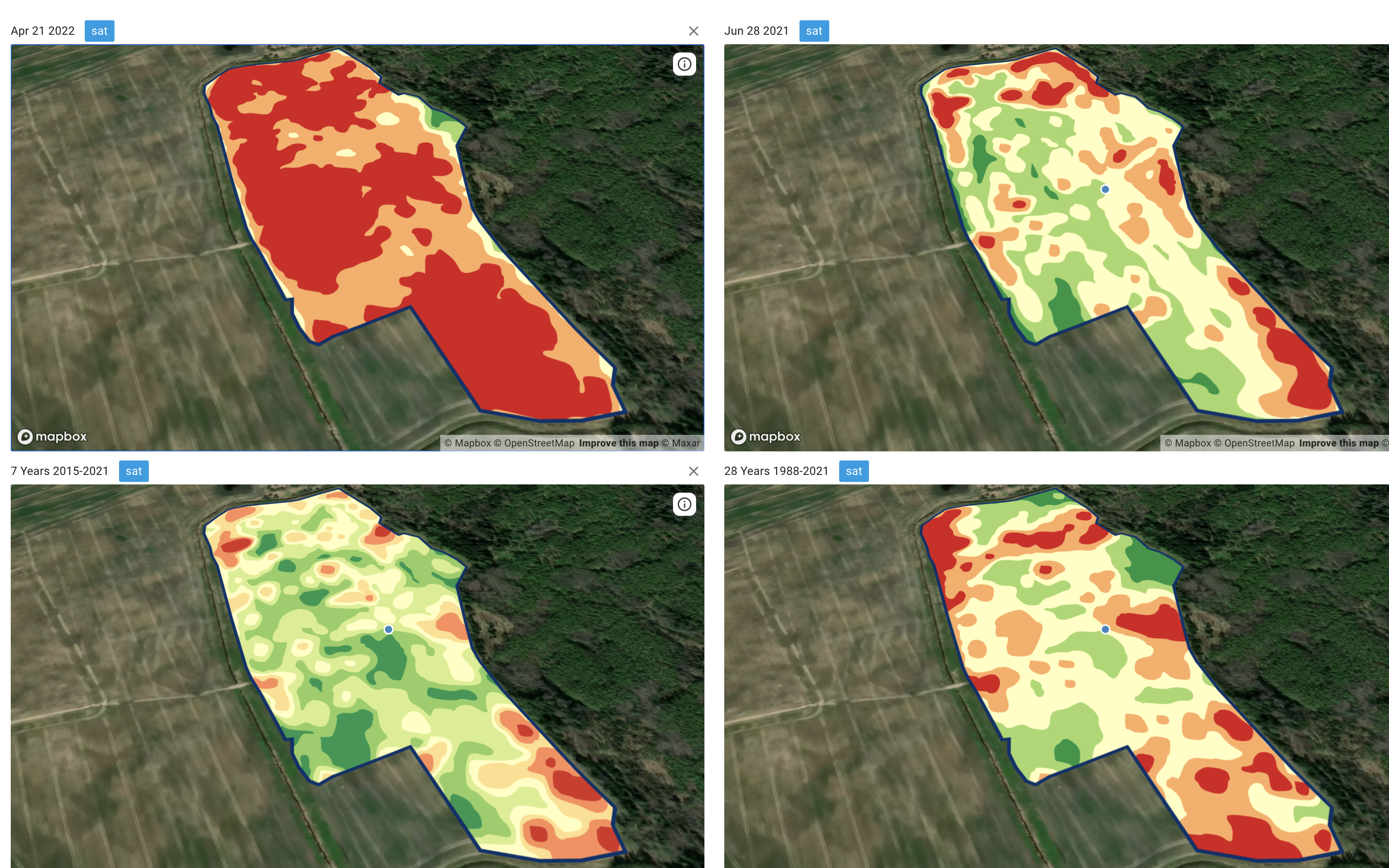
Historical imagery offers a wealth of information. It allows you to track changes and trends over time. By analyzing this data, you can predict future challenges and opportunities. This foresight helps in planning and resource allocation.

Imagine knowing exactly how a field responds to certain treatments over the years. This knowledge makes future planning more effective. You’re not just reacting to changes; you’re anticipating them, ensuring your fields remain productive.

Driving Trials and Demos with Precision

Precision is key when it comes to trials and demos. It’s about showcasing the effectiveness of your strategies and tools.

Implementing Bi-Directional Data Sync

Bi-directional data sync ensures that information flows seamlessly between systems. This feature keeps your data current and consistent. It’s crucial for making real-time decisions during trials.

By maintaining data accuracy, you can trust the results of your trials. This reliability builds confidence in your strategies and showcases their effectiveness. Stakeholders can see the real impact of data-driven decisions.

Conducting ROI Analysis and Profitability Mapping

ROI analysis is essential for understanding the financial impact of your strategies. With GeoPard, you can map profitability across different zones. This analysis highlights which areas deliver the best returns.

Profitability mapping guides your investment decisions. It shows where to focus resources for maximum gain. With clear insights, you can make informed financial decisions that enhance overall profitability.

Engaging with Free Trials and Subscriptions

Free trials and subscriptions offer a low-risk way to explore GeoPard’s capabilities. They provide hands-on experience with the tools and features. This engagement helps you see firsthand how GeoPard can transform your operations.

By trying these tools, you gain confidence in their benefits. It’s about understanding how GeoPard fits into your workflow and enhances decision-making. Embrace these opportunities to fully realize the potential of precision agriculture.

By leveraging these insights and tools, you’re not just planning for Q2; you’re setting the foundation for ongoing success.

Prepare for smarter farm decisions this year

How Advanced Analytics Helped Agribusinesses Overcome Q1 Hurdles: A Strategic Guide

How Advanced Analytics Helped Agribusinesses Overcome Q1 Hurdles: A Strategic Guide

Q1 throws a mix of weather swings, tight planting timelines, and rising input costs at agribusinesses every year. You’ve likely felt the pressure of these challenges cutting into your margins and decision-making. With advanced analytics for agribusiness, you can turn complex data into clear, actionable steps—like creating precise management zones and variable rate application maps—that keep your operations on track. Let’s explore how GeoPard’s AI-driven platform helped farms overcome these hurdles and deliver measurable ROI this season. For more insights, check out this document.

Navigating Q1 Agribusiness Challenges

Weather, prices, and planting windows create a perfect storm in Q1 for agribusinesses. Let’s see how you can navigate these challenges effectively.

Managing Weather Volatility with Precision

Weather unpredictability is a major concern for farmers. But what if you could forecast accurately and prepare better? GeoPard’s platform helps you use historical data and satellite imagery to understand weather patterns. This data lets you plan operations when conditions are just right.

For instance, using NDVI time series, you can track plant health and predict growth stages. This means you can optimize your crop management around expected weather changes, ensuring your crops thrive regardless of what Mother Nature throws your way.

Tackling Input Price Fluctuations

Why pay more when you can save smartly? Rising input costs can eat into profits, but smart planning makes a difference. GeoPard’s software analyzes your field data to recommend precise input levels. This means you use only what you need, cutting unnecessary costs.

Imagine reducing fertilizer use by 20% while maintaining yield. By understanding yield and soil data integration, you’re not just guessing; you’re making data-backed decisions that result in savings.

Addressing Tight Planting Windows

Timing is everything in planting. Miss the window, and yields suffer. GeoPard’s crop monitoring platform keeps you informed about optimal planting times. With real-time data, you can seize the perfect moment.

Think of it this way: instead of rushing, you’re strategizing. Precise timing means healthier crops and better yields, putting you ahead in Q1.

Leveraging Precision Agriculture Software

Precision agriculture software transforms farming challenges into opportunities. Here’s how GeoPard leads the way with its advanced tools.

GeoPard for Advanced Analytics

Why settle for guesswork when you can have precision? GeoPard offers advanced analytics for agribusiness, turning complex data into clear solutions. With over 20 years of satellite imagery, you gain a historical edge in planning.

This software doesn’t just provide data; it offers insights. By integrating topography analytics, you understand your land better, making informed decisions that boost productivity.

Smart Agronomic Recommendations

What if your software could think like an agronomist? GeoPard offers smart agronomic recommendations based on real-time data. The recommendations adapt to your specific fields, ensuring optimal input use and timing.

This means you’re not just managing your fields; you’re mastering them. With precise recommendations, you enhance productivity and reduce waste.

Creating Management Zones and VRA Maps

Imagine knowing exactly where to plant, fertilize, or irrigate. GeoPard’s tools allow you to create management zones and variable rate application maps tailored to your fields. These maps ensure every input is used effectively.

Instead of a one-size-fits-all approach, you have a customized strategy that reflects your unique landscape, leading to better resource management and higher yields.

Realizing ROI with Data-Driven Agronomy

Data is power, especially in agriculture. Let’s explore how you turn data into profit with GeoPard.

Crop Monitoring and Decision Support

Picture having a personal assistant for your fields. GeoPard’s crop monitoring platform offers in-season decision support, keeping you updated on crop health and growth. This proactive monitoring means fewer surprises and more informed decisions.

By spotting issues early, you save on potential losses, turning challenges into opportunities for improvement.

Integrating Yield and Soil Data

Your soil tells a story. By integrating yield and soil data, you understand your fields better. GeoPard’s platform helps you combine these data points to enhance decision-making, ensuring every action is guided by facts.

This integration means better planning, optimized input use, and ultimately, higher returns on your investment.

John Deere Operations Center Bi-Directional Sync

In the fast-paced world of farming, flexibility is key. GeoPard’s integration with John Deere Operations Center provides bi-directional data sync, ensuring your data flows smoothly between platforms. This seamless integration means your operations are always up-to-date.

By syncing data, you streamline processes, reduce errors, and enhance efficiency, leading to a higher ROI. This approach not only saves time but also positions you for success in agribusiness.

Prepare for smarter farm decisions this year

Streamlining Farm Data Workflows: Q1 insights and actionable tips for ag service providers

Streamlining Farm Data Workflows: Q1 Insights and Actionable Tips for Ag Service Providers

You just spent hours juggling fragmented data across multiple platforms and still can’t get a clear picture of your fields. Farm data workflows often slow down agronomists and service providers more than they realize. In this post, you’ll find Q1 insights revealing common bottlenecks and practical tips to streamline your data ingestion, analysis, and delivery using GeoPard’s precision agriculture software. Learn more here.

Key Q1 Farm Data Insights

Understanding Q1 farm data insights can illuminate significant challenges and solutions for agronomists. Let’s explore common workflow issues and how GeoPard makes a difference.

Common Data Workflow Bottlenecks

Agricultural data often sits in silos, leading to delays. Imagine trying to merge data from multiple sources manually. This can take hours. Many service providers report that over 50% of their time gets lost in data wrangling. The complexity of handling different formats is another hurdle. Most people think that having large amounts of data is beneficial, but it can overwhelm if not managed well.

GeoPard’s Role in Streamlining

GeoPard’s software simplifies these workflows, making data more accessible. By consolidating information from various sources, it reduces processing time significantly. With GeoPard, you can integrate and analyze data in real-time. This approach challenges the belief that data management has to be cumbersome. Instead, it’s about efficiency and clarity.

Streamlining Data Processes

Improving how you handle farm data can transform your agricultural operations. Let’s see how you can optimize each stage, from ingestion to delivery.

Ingesting Agricultural Data Efficiently

The first step is gathering data effectively. GeoPard supports multiple data types, including soil sensors and satellite imagery. This integration enables a seamless collection process. For instance, using automated data entry, you can reduce errors and save time. Many think manual entry is unavoidable, but automation proves otherwise.

Analyzing with Precision Agriculture Software

Once you’ve collected data, analysis becomes crucial. GeoPard’s precision software uses AI to provide deep insights. You can generate management zones and variable rate application maps. This means you can make informed decisions faster. A key insight: precise data analysis leads to better crop management.

Delivering Insights to Ag Service Providers

Finally, delivering insights efficiently is vital. GeoPard ensures that service providers receive timely reports. This includes yield data analysis and topography analytics. By sharing clear insights, you help clients optimize their operations. The longer you wait to streamline, the more opportunities you miss.

Actionable Tips for Service Providers

Enhance your service offerings with practical steps. These tips will help you harness GeoPard’s capabilities effectively.

Implementing a Practical Checklist

Creating a checklist can guide your workflow improvements. Start with assessing your current data sources. Then, identify integration opportunities with platforms like GeoPard. Regularly reviewing this checklist ensures continuous improvement. Here’s the key insight: structured processes lead to better outcomes.

Engaging with GeoPard’s Free Trial

Trying out GeoPard’s trial can demonstrate its potential. During the trial, explore features like AI agronomy analytics and field analytics platforms. This hands-on experience can show you how it fits into your workflow. Most people hesitate to try new software, but trials offer risk-free exploration.

Integration with John Deere Operations Center

GeoPard integrates seamlessly with systems like the John Deere Operations Center. This bi-directional data sync enhances collaboration. By using such integrations, you can streamline operations further. It challenges the idea that systems must remain isolated. Instead, interconnected platforms offer greater value.

In conclusion, streamlining your farm data workflows with GeoPard can lead to significant operational improvements. From ingestion to delivery, each step offers opportunities for optimization. Adopting these practices will not only improve efficiency but also enhance your service offerings.

Prepare for smarter farm decisions this year

wpChatIcon
wpChatIcon

    Request Free GeoPard Demo / Consultation


    By clicking the button you agree our Privacy Policy. We need it to reply to your request.

      Subscribe


      By clicking the button you agree our Privacy Policy

        Send us information


        By clicking the button you agree our Privacy Policy