
Cloud and Shadow detection is one of the most important tasks in analytical remote sensing solutions.
If the whole satellite image is 90% clean, there is still a 10% chance that your field will be under clouds/shadows area. The reverse is also true – many systems do not process images with clouds above 70% – although the remaining 30% can help the agronomist or farmer to make the right decision during the season.
At GeoPard, we solve this problem with the help of several machine learning algorithms that work with very high accuracy.

We define a cloud mask and a shadow mask at the level of the whole image, and for each field-image pair, we consider what percentage of the field is covered by clouds or shadows from the clouds.
In automatic analytics, we take only completely cloudless images for a specific field, which allows the user to be confident in making decisions based on multi-year analytics.
The GeoPard user has the opportunity to view and even run the analytics himself, even on partially cloudy images.

This can still be very useful, for example, during the season to apply Variable Rate spraying with crop protection products based on the latest satellite image, in which 10% of the field’s area is under the clouds. This means that for 90% of the field’s area, the decision will be based on verified data.
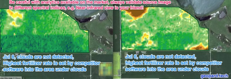
Also, users of GeoPard can easily check source images on a regional level in Near-Infrared view, which helps to distinguish clear land from clouds and shadows (see picture attached).
On UI cloud filter is located in the top menu of “Satellite monitoring” module, see screenshots attached.

Keep in mind that digital ag companies can still struggle with the correct detection of clouds and shadows. In the attached screenshot one such a company creates VR fertilizer map based on clouds and shadows data. So the wrong map leads to wrong agronomic decisions and wrong outcomes in the end.
GeoPard detects clouds and shadows with a high level of accuracy and doesn’t propose to make your Variable Rate decision based on clouds. You can always look at the source images in different views and indices and zoom out to see the picture around.

Not every solution is the same, choose the best options available on the market!
What is Cloud Detection in Precision Agriculture?
Cloud detection in precision agriculture refers to the process of identifying and monitoring cloud cover in agricultural areas using remote sensing technologies. Clouds can significantly impact agricultural practices and crop productivity, making their detection and analysis crucial for effective farm management.
It involves the use of various sensors, such as satellites, drones, or ground-based instruments, to capture imagery of agricultural fields. These sensors capture data in the form of visible and infrared light, which can be analyzed to determine cloud presence and characteristics.
Its primary purpose in precision agriculture is to assess the spatial and temporal distribution of clouds over agricultural areas.
This information helps farmers and agronomists make informed decisions regarding irrigation, fertilization, pest control, and other farming practices. By understanding cloud cover patterns, farmers can optimize resource allocation and minimize the risk of crop damage or yield reduction.
Cloud detection algorithms analyze the captured imagery to differentiate between cloud pixels and non-cloud pixels.
These algorithms utilize various techniques, such as thresholding, spectral analysis, and machine learning, to identify and classify cloud formations accurately.
The output of algorithms typically includes cloud coverage percentage, cloud type classification, and cloud movement patterns.
Once clouds are detected and their characteristics are determined, farmers can utilize this information to implement precision agriculture techniques.
For example, if a cloud is detected over a specific area of a field, farmers may delay irrigation or pesticide application in that region until the cloud passes. By synchronizing agricultural activities with cloud movements, farmers can optimize resource utilization and minimize unnecessary inputs.
It is particularly beneficial in regions with high cloud cover or where weather patterns change rapidly. By continuously monitoring cloud cover, farmers can adapt their farming practices in real-time, making adjustments based on current weather conditions.
In summary, cloud detection in precision agriculture plays a crucial role in optimizing farming practices and resource management. By accurately identifying and monitoring cloud cover, farmers can make informed decisions to enhance crop productivity, reduce input wastage, and mitigate the risks associated with changing weather conditions.
Remote Sensing


