Topography often has a huge influence on nutrient distribution and yield potential. GeoPard creates topographic models from machinery, remote sensing and if available LIDAR datasets.
Let’s dive deeper into the new topographic derivatives we just added to GeoPard.
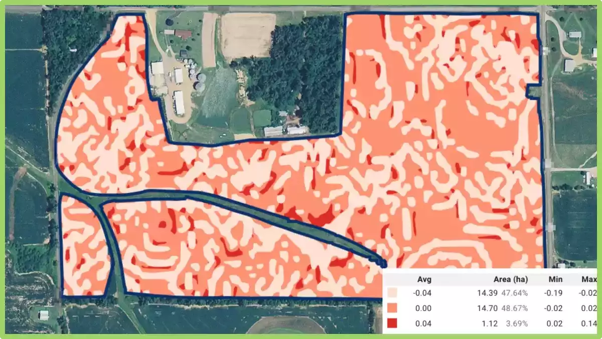
Relief Position is defined as the difference between a central pixel and the mean of its surrounding cells. In other words, spots with negative values mean field lowland, spots with positive values – field highland.
You can have a hilltop in a “low” elevation that has very different soil properties than a mid slope or depression. Elevation, slope and aspect cannot show this. Relief position is calculated in meters.

Slope is the angle of inclination to the horizontal. Usually, it is calculated in degrees or percent slope. GeoPard does that in degrees.

Ruggedness is defined as the mean difference between a central pixel and its surrounding cells. In other words, ruggedness describes the slope in absolute numbers (in meters) for every particular location (pixel).

Roughness is the degree of irregularity of the surface. It’s calculated by the largest inter-cell difference of a central pixel and its surrounding cell. In other words, it measures the maximum absolute value of the slope in meters for every location (pixel).

These four topographic derivatives reflect the slope details but in a bit different flavour.

What is Topographic Modeling?
Topographic modeling is the process of creating a three-dimensional representation of the Earth’s surface. This is done by collecting data on the elevation of the land, such as through surveying or satellite imagery, and then using this data to create a digital elevation model (DEM).
The DEM can then be used to create a variety of outputs, such as topographic maps, 3D models, and even virtual reality experiences.
It has a wide range of applications, including:
- Planning and development: Topographic models can be used to plan and develop infrastructure, such as roads, railways, and pipelines. They can also be used to assess the impact of development on the environment.
- Environmental management: Topographic models can be used to monitor and manage natural resources, such as water, forests, and wildlife. They can also be used to assess the impact of climate change on the environment.
- Education and research: Topographic models can be used to educate the public about the Earth’s surface and its features. They can also be used by researchers to study the Earth’s surface and its processes.
How is Topographic Modeling Done?
It can be done in a variety of ways, but the most common method is to use a DEM.
A DEM is a gridded representation of the Earth’s surface, with each cell in the grid representing a point with a known elevation. DEMs can be created from a variety of sources, including:
- Surveying: Surveyors use a variety of tools to measure the elevation of the land, such as levels, theodolites, and GPS receivers.
- Satellite imagery: Satellites can be used to create DEMs by measuring the distance between the satellite and the Earth’s surface.
- Aerial photography: Aerial photographs can be used to create DEMs by measuring the distance between the camera and the Earth’s surface.
Once a DEM has been created, it can be used to create a variety of outputs, such as topographic maps, 3D models, and even virtual reality experiences.
Benefits of Topographic Modeling
Further, it offers a number of benefits, including:
- Accuracy: DEMs are highly accurate representations of the Earth’s surface. This is important for applications such as planning and development, where accuracy is essential.
- Visualization: Topographic models provide a clear and concise visualization of the Earth’s surface. This can be helpful for understanding the relationship between different features, such as mountains, valleys, and rivers.
- Analysis: Topographic models can be used to analyze the Earth’s surface. This can be used to identify areas that are at risk of flooding, landslides, or other natural disasters.
- Communication: Topographic models can be used to communicate information about the Earth’s surface to a wide range of audiences. This can be helpful for educating the public about the Earth’s surface and its features.
What is Topography Lidar?
Lidar (Light Detection and Ranging) is a remote sensing technology that uses light to measure distance to the Earth’s surface. It works by sending out a laser pulse and measuring the time it takes for the pulse to return. This information can be used to create three-dimensional (3D) models of the Earth’s surface.
Topographic lidar is a type of lidar that is specifically used to create 3D models of the Earth’s topography.
How Topography Lidar Works
These systems typically consist of a laser, a scanner, and a GPS receiver. The laser is used to emit pulses of light, the scanner is used to measure the direction of the pulses, and the GPS receiver is used to track the location of the system.
The laser pulses are emitted in a series of lines, and the scanner measures the intensity of the pulses as they return. This information is used to create a 3D model of the Earth’s surface.
Its data accuracy depends on a number of factors, including the power of the laser, the sensitivity of the scanner, and the speed of the GPS receiver.
Applications of Topography Lidar
It data can be used for a variety of applications, including:
- Mapping the Earth’s surface
- Monitoring changes in the Earth’s surface
- Assessing natural hazards
- Planning infrastructure projects
- Conducting scientific research
Mapping the Earth’s surface
It can be used to create detailed maps of the Earth’s surface. These maps can be used for a variety of purposes, such as planning infrastructure projects, assessing natural hazards, and conducting scientific research.
Monitoring changes in the Earth’s surface
It can be used to monitor changes in the Earth’s surface over time. This information can be used to track the effects of natural processes, such as erosion and sedimentation, and human activities, such as deforestation and construction.
Assessing natural hazards
It is used to assess natural hazards, such as landslides, floods, and earthquakes. This information can be used to identify areas that are at risk and to develop mitigation strategies.
Planning infrastructure projects
It is used to plan infrastructure projects, such as roads, bridges, and pipelines. This information can be used to identify the best routes for projects and to minimize the impact on the environment.
Conducting scientific research
It can be used to conduct scientific research on a variety of topics, such as geology, hydrology, and ecology. This information can be used to better understand the Earth’s systems and to develop new technologies.
Benefits of Topography Lidar
It has a number of benefits over other methods of mapping the Earth’s surface, including:
- Accuracy: It is very accurate, making it ideal for applications where precision is important.
- Speed: It can be collected quickly, making it a cost-effective option for large-scale mapping projects.
- Flexibility: It can be used to map a variety of features, including both natural and man-made objects.
- 3D data: It is 3D, which allows for more accurate and detailed representations of the Earth’s surface.
Topographic modeling is a powerful tool that can be used to create a variety of outputs, including topographic maps, 3D models, and even virtual reality experiences. It offers a number of benefits, including accuracy, visualization, analysis, and communication.
Topography


