Жеңіл YOLOv5 анықтау жүйесі арқасында арпа өсіру серпін алады

Қытайдың Цинхай-Тибет таулы платосының биік аймақтарында өсірілетін төзімді астық дақылы – таулы арпа жергілікті азық-түлік қауіпсіздігі мен экономикалық тұрақтылықты қамтамасыз етуде шешуші рөл атқарады. Ғылыми атауы Hordeum vulgare L., бұл дақыл экстремалды жағдайларда – жұқа ауада, оттегінің төмен деңгейінде және орташа жылдық температурасы 6,3°C – жақсы өседі, сондықтан ол қатал ортадағы қауымдастықтар үшін таптырмас.

Қытайда, негізінен Сицанг автономиялық аймағында оның өсірілуіне 270 000 гектардан астам жер бөлінген, таулы арпа аймақтағы егілген алқаптың жартысынан астамын және жалпы дән өндірісінің 701 TP3T-дан астамын құрайды. Арпа тығыздығын — бірлік аумаққа түсетін өсімдіктер немесе масақтар санын — дәл бақылау суару мен тыңайту сияқты ауылшаруашылық тәсілдерін оңтайландыру және өнімді болжау үшін өте маңызды.

Дегенмен, қолмен үлгі алу немесе спутниктік суретке түсіру сияқты дәстүрлі әдістер тиімсіз, еңбекке көп кететін немесе жеткілікті деңгейде егжей-тегжейлі емес болып шықты. Осы мәселелерді шешу үшін Фуцзянь ауыл шаруашылығы және орман шаруашылығы университеті мен Чэнду технологиялық университетінің зерттеушілері озық нысанды анықтау алгоритмі YOLOv5 негізіндегі инновациялық жасанды интеллект моделін әзірледі.

Олардың жұмысы жарияланған Өсімдік әдістері (2025) ерекше нәтижелерге қол жеткізді, соның ішінде жалпы анықтау дәлдігін өлшейтін орташа дәлдік көрсеткіші (mAP) 93.1% және есептеу шығындарын 75.6%-ға азайту, бұл оны нақты уақыттағы дрондарды қолдануға жарамды етеді.

Егінді бақылау саласындағы мәселелер мен инновациялар

Таулы арпаның маңызы тағам көзі ретіндегі рөлінен әлдеқайда асып түседі. Тек 2022 жылы арпа өсірумен айналысатын ірі өңір Риказе қаласында 60 000 гектар алқаптан 408 900 тонна арпа жиналып, бұл Тибеттің жалпы дән өнімінің жартысына жуығын құрады.

Мәдени және экономикалық маңызына қарамастан, арпа өнімін бағалау ұзақ уақыт бойы қиындық тудырып келеді. Дәстүрлі әдістер, мысалы қолмен санау немесе спутниктік суреттер, тым еңбекке сыйымды немесе жеке арпа шиелерін анықтауға қажетті ажыратымдылықтан айырылады — өсімдіктің дәндерін таситын бөлігі, әдетте ені небәрі 2–3 сантиметр.

Қолмен сынама алу фермерлерден егіс алқабының бөліктерін физикалық түрде тексеруді талап етеді — бұл үдеріс баяу, субъективті және ірі ауқымды шаруашылықтар үшін тиімсіз. Спутниктік суреттер кең ауқымды бақылаулар үшін пайдалы болғанымен, олардың төмен ажыратымдылығы (әдетте пиксельге шаққанда 10–30 метр) және жиі болатын ауа райы кедергілері, мысалы, Тибет сияқты таулы аймақтардағы бұлттылық, қиындық тудырады.

Осы шектеулерді еңсеру үшін зерттеушілер 20 мегапиксельді камералармен жабдықталған адамсыз ұшу аппараттарына (UAV), немесе дрондарға жүгінді. Бұл дрондар Риказе қаласындағы арпа алқаптарының өсудің екі маңызды кезеңінде 501 жоғары ажыратымдылықтағы суретті түсірді: 2022 жылғы тамыздағы өсу кезеңі, жасыл дамып келе жатқан масалармен сипатталатын, және 2023 жылғы тамыздағы пісіп-жетілу кезеңі, алтын-сары, жинауға дайын масалармен белгіленетін.

Риказе қаласындағы дрондар арқылы арпа егісін бақылау

Алайда, осы суреттерді талдау бірқатар қиындықтар туғызды, соның ішінде дрондағы қозғалыстан туындаған шекаралардың бұлыңғырлануы, әуеден түсірілген кадрлардағы арпа сабандарының кішкентай көлемі және тығыз егілген алқаптардағы сабандардың үсті-үстіне жабылуы.

Осы мәселелерді шешу үшін зерттеушілер әрбір жоғары ажыратымдылықтағы суретті 35 кіші суретке бөліп, бұлыңғыр жиектерді сүзгіден өткізу арқылы 2 970 жоғары сапалы кіші суретті оқытуға дайындады. Бұл алдын ала өңдеу кезеңі модельдің анық әрі пайдалы деректерге шоғырлануын қамтамасыз етіп, төмен сапалы аймақтардың назар аудартуына жол бермеді.

Объектілерді анықтаудағы техникалық жетістіктер

Осы зерттеудің негізгі бөлігі – YOLOv5 алгоритмі (You Only Look Once, 5-нұсқа), жылдамдығы мен модульдік құрылымымен танымал бір сатылы нысанды анықтау моделі. Faster R-CNN сияқты ескі екі сатылы модельдер алдымен қызықтыратын аймақтарды анықтап, содан кейін нысандарды жіктесе, YOLOv5 анықтауды бір ғана өтуде орындайды, бұл оны айтарлықтай жылдам етеді.

Негізгі YOLOv5n моделі 1,76 миллион параметрмен (ЖИ моделінің бапталатын компоненттері) және 4,1 миллиард FLOPs (жартылай жүздік операциялар, есептеу күрделілігін өлшеу бірлігі) көрсеткішімен қазірдің өзінде тиімді болды. Алайда ұсақ, бір-біріне үсті-үстіне түсетін арпа сабақтарын анықтау қосымша оңтайландыруды талап етті.

Зерттеу тобы модельге үш негізгі жаңарту енгізді: тереңдік бойынша бөлінетін конволюция (DSConv), елес конволюциясы (GhostConv) және конволюциялық блокқа арналған назар аудару модулі (CBAM).

Тереңдік бойынша бөлінетін конволюция (DSConv) стандартты конволюция процесін — кескіннен ерекшеліктерді анықтайтын математикалық операцияны — екі қадамға бөлу арқылы есептеу шығындарын азайтады. Алдымен тереңдік бойынша конволюция жеке түс арналарына (мысалы, қызыл, жасыл, көк) фильтрлерді қолдана отырып, әр арнаны бөлек талдайды.

Одан кейін арналар бойымен 1×1 ядроларын пайдалана отырып нәтижелерді біріктіретін нүктелік конволюция жүргізіледі. Бұл тәсіл параметрлер санын 75%-ге дейін қысқартады.

Тереңдік бойынша бөлінетін конволюцияда параметрлерді азайту

Мысалы, дәстүрлі 3×3 конволюция 64 кіріс және 128 шығыс арна үшін 73 728 параметр талап етеді, ал DSConv оны небәрі 8 768-ге дейін қысқартады — 88% азайту. Бұл тиімділік өңдеу қуаты шектеулі дрондарға немесе мобильді құрылғыларға модельдерді орналастыруда аса маңызды.

Ghost convolution (GhostConv) ресурс көп қажет ететін convolutions-тың орнына айналдыру немесе масштабтау сияқты қарапайым сызықты операциялар арқылы қосымша ерекшелік карталарын (сурет үлгілерінің ықшамдалған бейнелері) жасап, модельді одан әрі жеңілдетеді.

Дәстүрлі конволюциялық қабаттар артықша ерекшеліктер жасап, есептеу ресурстарын ысырап етеді. GhostConv бұған бар ерекшеліктерден “ghost” ерекшеліктерін жасау арқылы шешім табады, нәтижесінде кейбір қабаттардағы параметрлер саны тиімді түрде жартысына дейін қысқарады.

Мысалы, 64 кіріс және 128 шығыс арнасы бар қабат дәстүрлі түрде талап етеді 73 728 параметрлер, бірақ GhostConv оны мынадай етіп қысқартады 36,864 дәлдікті сақтай отырып. Бұл әдіс есептеу тиімділігі аса маңызды болатын арпа сабақтары сияқты кішігірім нысандарды анықтауда ерекше пайдалы.

Конволюциялық блокқа назар аудару модулі (CBAM) модельге тіпті шатасқан ортада да маңызды сипаттамаларға шоғырлануға көмектесу үшін енгізілді. Адамның көру жүйесінен шабыт алған назар аудару механизмдері AI модельдеріне суреттің маңызды бөліктерін басымдықпен қарауға мүмкіндік береді.

CBAM екі түрлі назарды пайдаланады: арналық назар маңызды түс арналарын анықтайды (мысалы, өсіп келе жатқан шиптер үшін жасыл), ал кеңістіктік назар суреттегі негізгі аймақтарды (мысалы, шиптер кластерлерін) айқындайды. Стандартты модульдерді DSConv және GhostConv-пен алмастырып, CBAM-ды енгізу арқылы зерттеушілер арпаны анықтауға арналған ықшам әрі дәлірек модель жасады.

Іске асыру және нәтижелер

Модельді оқыту үшін зерттеушілер 135 бастапқы суретті қолмен белгілеп, арпа сабандарының орнын белгілейтін тіктөртбұрышты жақтауларды пайдаланды және сабандарды өсу мен пісіп-жетілу кезеңдеріне жіктеді. Деректерді кеңейту әдістері — айналдыру, шу енгізу, жабу және өткірлеу — деректер жиынтығын 2 970 суретке дейін ұлғайтып, модельдің әртүрлі дала жағдайларында жалпылау қабілетін жақсартты.

Мысалы, суреттерді 90°, 180° немесе 270° бұру моделіне шұңқырларды әртүрлі бұрыштардан тануға көмектесті, ал шуды қосу шаң-тозаң мен көлеңке сияқты нақты әлемдегі кемшіліктерді имитациялады. Деректер жиынтығы оқыту жиынтығына (80%) және валидация жиынтығына (20%) бөлінді, бұл сенімді бағалауды қамтамасыз етті.

Оқыту жоғары өнімді жүйеде өтті: AMD Ryzen 7 процессоры, NVIDIA RTX 4060 бейнежады және 64 ГБ жедел жады қолданылып, терең оқытуға арналған танымал PyTorch фреймворкі пайдаланылды. 300-ден астам оқыту эпохында (мәліметтер жиынтығын толық өту) модельдің дәлдігі (дұрыс анықталғандардың дәлдігі), recall (барлық тиісті спайктерді табу қабілеті) және loss (қателік деңгейі) мұқият бақыланды.

Нәтижелер таң қалдырарлық болды. Жақсартылған YOLOv5 моделі дәлдігі 92,2% (базалықтағы 89,1%-ден жоғары) және еске алу көрсеткіші 86,2% (83,1%-ден жоғары) көрсетті, екі көрсеткіш бойынша да бастапқы YOLOv5n-нен 3,1%-ге озып түсті. Оның орташа жалпы дәлдігі (mAP) — барлық санаттар бойынша анықтау дәлдігін орташа есеппен өлшейтін жан-жақты көрсеткіш — 93,1%-ке жетті, оның ішінде өсу кезеңінің шыңдары үшін 92,7% және жетілу кезеңінің шыңдары үшін 93,5%.

YOLOv5 модельін оқыту нәтижелері

Сонымен қатар оның есептеу тиімділігі де бірдей таң қалдырды: модель параметрлері 70,61 есе қысқарды да 1,2 миллионға дейін төмендеді, ал FLOPS көрсеткіші 75,61 есе азайып, 3,1 миллиардқа дейін қысқарды. Faster R-CNN және YOLOv8n сияқты жетекші модельдермен салыстырмалы талдаулар оның артықшылығын көрсетті.

YOLOv8n сәл жоғары mAP (93,8%) көрсеткішіне қол жеткізгенімен, оның параметрлері (3,0 миллион) мен FLOPs (8,1 миллиард) тиісінше 2,5 және 2,6 есе көп болғандықтан, ұсынылған модель нақты уақыттағы қолданбалар үшін әлдеқайда тиімді.

Көзбен салыстыру осы жетістіктерді айқын көрсетті. Өсу кезеңіндегі суреттерде жетілдірілген модель бастапқы модельмен салыстырғанда 41 шыңды анықтады, ал бастапқы модель 28-ді анықтаған. Пісіп-жетілу кезеңінде ол 3 шыңды анықтады, ал бастапқы модель 2-ні анықтаған, сонымен қатар жіберіп алған анықтаулар (апельсин түсті жебелермен белгіленген) мен жалған оң нәтижелер (күлгін түсті жебелермен белгіленген) азайды.

Осы жетілдірулер өнімділікті болжау және ресурстарды оңтайландыру үшін дәл деректерге сүйенетін фермерлер үшін өте маңызды. Мысалы, дәл бүршік санын есептеу дән өнімін жақсырақ болжауға мүмкіндік береді, бұл орақ уақытын, сақтау және нарықты жоспарлау жөніндегі шешімдерді қабылдауға көмектеседі.

Болашақ бағыттар және практикалық салдары

Зерттеудің табыстарына қарамастан, оның шектеулері бар екені мойындалды. Өнімділік қатты түскі күн сәулесінің жарқылы немесе қою көлеңке сияқты экстремалды жарық жағдайларында төмендеді, олар шиптің бөлшектерін жасырып қалуы мүмкін. Сонымен қатар, тіктөртбұрышты шекаралық қораптар кейде дөрекі пішінді шиптерге сыймай, кішігірім дәлсіздіктерге әкелді.

Модель сондай-ақ ұшқышсыз ұшу аппаратының (UAV) суреттеріндегі бұлыңғыр жиектерді шығармайды, бұл қолмен алдын ала өңдеуді қажет етеді — бұл қадам уақыт пен күрделілікті арттырады.

Болашақ жұмыс осы мәселелерді таң сәріден, түстен және кеш батқан кезде түсірілген суреттерді деректер жиынтығына қосу, полигон пішінді аннотацияларды (бұрмаланған нысандарға жақсырақ сәйкес келетін икемді пішіндер) сынап көру және бұлыңғыр аймақтарды қолмен араласусыз жақсырақ өңдеуге арналған алгоритмдерді әзірлеу арқылы шешуді мақсат етеді.

Бұл зерттеудің маңызы зор. Тибет сияқты аймақтардағы фермерлер үшін бұл модель егін өнімділігін нақты уақыт режимінде бағалауды ұсынады, еңбекке сыйымды қолмен санауды дрондар негізіндегі автоматтандырумен алмастырады. Өсу кезеңдерін ажырату егін жинауды дәл жоспарлауға мүмкіндік береді, ерте немесе кешіктірілген орақтан келетін шығындарды азайтады.

Шоқтар тығыздығы туралы егжей-тегжейлі мәліметтер — мысалы, аз қоныстанған немесе тым тығыз аймақтарды анықтау — суару мен тыңайту стратегияларын жетілдіріп, су мен химикаттардың ысырап болуын азайтуға мүмкіндік береді. Арпадан бөлек, бұл жеңіл құрылым бидай, күріш немесе жеміс сияқты басқа да дақылдарға үміт күттіріп, дәл ауыл шаруашылығында кеңінен қолдануға жол ашады.

Қорытынды

Қорытындылай келе, бұл зерттеу ауыл шаруашылығындағы мәселелерді шешуде жасанды интеллекттің трансформативтік әлеуетін айқын көрсетеді. Зерттеушілер YOLOv5-ті инновациялық жеңіл әдістер арқылы жетілдіріп, дәлдік пен тиімділікті үйлестіретін құралды жасады, бұл ресурстары шектеулі нақты жағдайларда қолдану үшін аса маңызды.

mAP, FLOPs және назар аудару механизмдері сияқты терминдер техникалық болып көрінгенімен, олардың әсері терең практикалық: олар фермерлерге деректерге негізделген шешімдер қабылдауға, ресурстарды үнемдеуге және өнімділікті барынша арттыруға мүмкіндік береді. Климаттың өзгеруі мен халық санының өсуі жаһандық азық-түлік жүйелеріне қысымды күшейте түскен сайын, мұндай жетістіктер таптырмас болады.

Тибет пен одан тыс аймақтардағы фермерлер үшін бұл технология тек ауыл шаруашылығы тиімділігіндегі секіріс қана емес, белгісіз болашақтағы тұрақты азық-түлік қауіпсіздігіне үміт сәулесі болып табылады.

Дереккөз: Цай, М., Дэн, Х., Цай, Дж. және т.б. Жақсартылған YOLOv5 негізіндегі жеңіл таулы арпаны анықтау. Plant Methods 21, 42 (2025). https://doi.org/10.1186/s13007-025-01353-0

Өнімділік деректерін автоматтандырылған тазалау және калибрлеу

Automated Yield Data Cleaning and Calibration (AYDCC) is a process that uses algorithms and models to detect and correct errors in yield data, such as outliers, gaps, or biases. AYDCC can improve the quality and reliability of yield data, which can lead to better insights and recommendations for farmers.

Introduction to Yield Data

Yield data is one of the most important sources of information for farmers in the 21st century. It refers to the data collected from various farm machinery, such as combines, planters, and harvesters, that measure the quantity and quality of crops produced in a given field or area.

It holds immense importance for several reasons. Firstly, it aids farmers in making informed decisions. Armed with detailed yield data, farmers can fine-tune their practices to maximize productivity.

For instance, if a specific field consistently produces lower yields, farmers can investigate the underlying causes, such as soil health or irrigation issues, and take corrective measures.

Furthermore, it enables precision agriculture. By mapping variations in crop performance across their fields, farmers can tailor their input applications, such as fertilizers and pesticides, to specific areas. This targeted approach not only optimizes resource use but also reduces environmental impacts.

According to the Food and Agriculture Organization (FAO), global agricultural production needs to increase by 60% by 2050 to meet the growing demand for food. Yield data, through its role in enhancing crop productivity, is instrumental in achieving this target.

Furthermore, in Brazil, a soybean farmer used yield data along with soil sampling data to create variable-rate fertilizer maps for his fields. He applied different rates of fertilizer according to the soil fertility and yield potential of each zone.

He also used yield data to compare different soybean varieties and select the best ones for his conditions. As a result, he increased his average yield by 12% and reduced his fertilizer costs by 15%.

Similarly, in India, a rice farmer also used yield datasets along with weather data to adjust his irrigation schedule for his fields. He monitored the soil moisture levels and rainfall patterns using sensors and satellite imagery.

understanding and utilization of yield data

He also used it to compare different rice varieties and select the best ones for his conditions. As a result, he increased his average yield by 10% and reduced his water use by 20%.

Despite its benefits, yield data still faces some challenges in terms of its development and adoption. Some of these challenges are:

  • Data quality: Its accuracy and reliability depends on the quality of the sensors, the calibration of the machinery, the data collection methods, and the data processing and analysis techniques. Poor data quality can lead to errors, biases, or inconsistencies that can affect the validity and usefulness of the data.
  • Data access: The availability and affordability of yield data depend on the access to and ownership of the farm machinery, the sensors, the data storage devices, and the data platforms. Lack of access or ownership can limit the ability of farmers to collect, store, share, or use their own data.
  • Data privacy: Its security and confidentiality depends on the protection and regulation of the data by the farmers, the machinery manufacturers, the data providers, and the data users. Lack of protection or regulation can expose the data to unauthorized or unethical use, such as theft, manipulation, or exploitation.
  • Data literacy: The understanding and utilization of yield data depend on the skills and knowledge of the farmers, the extension agents, the advisors, and the researchers. Lack of skills or knowledge can hinder the ability of these actors to interpret, communicate, or apply the data effectively.
gathering datasets using farm machines like harvesters

Therefore, to overcome these challenges and realize the full potential of yield data, it is important to cleaning and calibrate the yield data.

Introduction to yield data cleaning and calibration

Yield data are valuable sources of information for farmers and researchers who want to analyze crop performance, identify management zones, and optimize decision-making. However, it often require cleaning and calibration to ensure their reliability and accuracy.

Calibrating the “YieldDataset” is a functionality that corrects the distribution of values in alignment with mathematical principles, enhancing the overall integrity of the data. It bolsters the quality of decision-making and renders the dataset valuable for further in-depth analysis.

GeoPard Yield Clean-Calibration Module

GeoPard made it possible to clean and correct yield datasets using its Yield Clean-Calibration module.

We’ve made it easier than ever to enhance the quality of your yield datasets, empowering farmers to make data-driven decisions that you can rely on.

GeoPard - Yield Cleaning & Calibration, similar to Field Potential zones

After calibration and cleaning, the resulting yield dataset becomes homogeneous, without outliers or abrupt changes between neighboring geometries.

With our new module, you can:

Select an option to proceed
  • Remove corrupted, overlapped, and subnormal data points
  • Calibrate yield values across multiple machines
  • Start calibration with just a few clicks (simplifying your user experience) or execute the associated GeoPad API endpoint

Some of the most common use cases of automated yield data cleaning and calibration include:

  • Synchronizing data when multiple harvesters have worked either simultaneously or over several days, ensuring consistency.
  • Making the dataset more homogeneous and accurate by smoothing out variations.
  • Removing data noise and extraneous information that can cloud insights.
  • Eliminating turnarounds or abnormal geometries, which may distort the actual patterns and trends in the field.

In the picture below, you can see a field where 15 harvesters worked at the same time. It shows how the original yield dataset and the improved dataset after calibration with GeoPard yield clean-calibration module look quite different and easy to understand.

difference between the original and improved yield datasets with GeoPard's Calibration Module

Why is it important to clean and calibrate?

Yield data are collected by yield monitors and sensors that are attached to harvesters. These devices measure the mass flow rate and moisture content of the harvested crop, and use GPS coordinates to georeference the data.

However, these measurements are not always accurate or consistent, due to various factors that can affect the performance of the equipment or the crop conditions. Some of these factors are:

1. Equipment variations: Farm machinery, such as combines and harvesters, often have inherent variations that can lead to discrepancies in data collection. These variations might include differences in sensor sensitivity or machinery calibration.

For example, some yield monitors may use a linear relationship between voltage and mass flow rate, while others may use a nonlinear one. Some sensors may be more sensitive to dust or dirt than others. These variations can cause discrepancies in yield data across different machines or fields.

Example 1 U-turns, Stops, Half Equipment Width Used
Example 2 U-turns, Stops, Half Equipment Width Used

2. Environmental factors: Weather conditions, soil types, and topography play significant roles in crop yields. If not accounted for, these environmental factors can introduce noise and inaccuracies into yield data.

For instance, sandy soils or steep slopes may cause lower yields than loamy soils or flat terrains. Likewise, areas with higher crop density may have higher yields than areas with lower density.

3. Sensor inaccuracies: Sensors, despite their precision, are not infallible. They may drift over time, providing inaccurate readings if not regularly calibrated.

For example, a faulty load cell or a loose wiring may cause inaccurate mass flow rate readings. A dirty or damaged moisture sensor may give erroneous moisture content values. A wrong field name or ID entered by the operator may assign yield data to the wrong field file.

These factors can result in yield datasets that are noisy, erroneous, or inconsistent. If these data are not cleaned and calibrated properly, they can lead to misleading conclusions or decisions.

For example, using uncleaned yield data to create yield maps may result in false identification of high- or low-yielding areas within a field.

Why is it important to clean and calibrate yield dataset

Using uncalibrated yield datasets to compare yields across fields or years may result in unfair or inaccurate comparisons. Using uncleaned or uncalibrated yield data to calculate nutrient balances or crop inputs may result in over- or under-application of fertilizers or pesticides.

Therefore, it is essential to perform yield data cleaning and calibration before using them for any analysis or decision-making purpose. Yield datasets cleaning is the process of removing or correcting any errors or noise in the raw yield data collected by the yield monitors and sensors.

Automated methods for cleaning and calibrating yield data

This is where automated data cleaning techniques come in handy. Automated data cleaning techniques are methods that can perform data cleaning tasks without or with minimal human intervention.

Configure the Calibrate step
Automated methods for cleaning and calibrating

Automated data cleaning techniques can save time and resources, reduce human errors, and enhance the scalability and efficiency of data cleaning. Some of the common automated data cleaning techniques for yield data are:

1. Outlier Detection: Outliers are data points that deviate significantly from the norm. Automated algorithms can identify these anomalies by comparing data points to statistical measures such as mean, median, and standard deviation.

For example, if a yield dataset shows an exceptionally high harvest yield for a particular field, an outlier detection algorithm can flag it for further investigation.

2. Noise Reduction: Noise in yield data can arise from various sources, including environmental factors and sensor inaccuracies.

Automated noise reduction techniques, such as smoothing algorithms, filter out erratic fluctuations, making the data more stable and reliable. This helps in identifying true trends and patterns in the data.

3. Data Imputation: Missing data is a common issue in yield data sets. Data imputation techniques automatically estimate and fill in missing values based on patterns and relationships within the data.

For instance, if a sensor fails to record data for a specific time period, imputation methods can estimate the missing values based on adjacent data points.

Hence, automated data cleaning techniques serve as the gatekeepers of data quality, ensuring that yield datasets remain a reliable and valuable asset for farmers worldwide.

Furthermore, there are lots of handy tools and computer programs that can automatically clean and adjust yield data, and GeoPard is one of them. The GeoPard Yield Clean-Calibration Module, along with similar solutions, is super important for making sure the data is accurate and reliable.

GeoPard - Yield Cleaning & Calibration - 3 harvesters

Қорытынды

Automated Yield Data Cleaning and Calibration (AYDCC) is essential in precision agriculture. It ensures the accuracy of crop data by removing errors and enhancing quality, enabling farmers to make informed decisions. AYDCC addresses data challenges and utilizes automated techniques for trustworthy results. Tools like GeoPard’s Yield Clean-Calibration Module simplify this process for farmers, contributing to efficient and productive farming practices.

Жабық дақылдарды өсіруді оңтайландыру үшін GPS технологиясын пайдалану

The agricultural industry is experiencing a big change, with the adoption of modern technologies like GPS systems becoming more common.

This is especially noticeable in how farmers grow cover crops. GPS technology is revolutionizing the way they manage their fields, helping them become more efficient and sustainable in their agricultural practices.

Cover crops, sometimes called green manure, are plants grown primarily to improve soil health rather than for harvest. They are usually cultivated during the off-season and provide benefits like controlling weeds, enhancing biodiversity, and boosting soil fertility.

Yet, growing cover crops can be laborious and time-consuming. That’s where GPS technology comes in handy.

Incorporating GPS technology into farming brings numerous advantages. Firstly, it allows precision farming, where farmers can use GPS coordinates to create precise maps of their fields.

This helps them closely monitor crop growth and soil conditions. By relying on data, they can apply fertilizers and pesticides more accurately, reducing waste and minimizing harm to the environment.

Moreover, GPS technology greatly boosts the efficiency of planting cover crops. Conventional methods may lead to uneven distribution of seeds, leaving some areas poorly covered.

With GPS-guided machinery, farmers can ensure even distribution across the entire field, promoting better growth and soil coverage. This not only enhances the effectiveness of the cover crops but also reduces the need for labor and resources.

Additionally, GPS technology enables farmers to implement more effective crop rotation strategies. With precise field mapping and crop growth tracking, they can optimize soil health and productivity through well-planned rotations. This can result in higher yields over time, further improving agricultural efficiency.

Moreover, GPS technology plays a vital role in monitoring and managing pests and diseases. It allows farmers to track the location and spread of these problems, enabling them to take targeted actions for control. As a result, the use of broad-spectrum pesticides can be reduced, promoting a healthier and more sustainable agricultural system.

GPS technology offers benefits beyond just individual farmers when it comes to cover crop cultivation. It has the potential to encourage sustainable and efficient agricultural practices on a global scale.

By reducing waste and making the best use of resources, GPS technology can play a significant role in meeting the rising global food demand in an environmentally friendly manner.

However, using GPS technology in agriculture poses challenges for many farmers, such as expensive upfront costs and a lack of technical know-how. To tackle these hurdles, it is crucial to offer support to farmers.

This can be achieved through financial incentives, training programs, and the development of user-friendly software and equipment, enabling them to make the most of this technology effectively.

In conclusion, using GPS technology in cover crop cultivation has the potential to significantly improve agricultural efficiency. It allows for precise farming, better seeding practices, effective crop rotation, and enhanced pest and disease management. By offering the right support and resources, farmers can take advantage of GPS technology to create a more sustainable and productive agricultural sector.

GeoPard пайда карталарын таныстыру: дәл ауыл шаруашылығындағы алға жылжу қадамы

Скриншоттағы мысалдағы пайда картасы тыңайтқыштарды қолдану, тұқым себу, екі рет дақылдарды қорғау және егін жинау сияқты қолданылған деректер жиынтығын ескереді. Есептеуге жерді дайындау, әртүрлі іс-шаралар сияқты басқа да шығындарды қосуға болады.

Дәл ауыл шаруашылығы - тиімділік пен кірістілікті арттыруға бағытталған деректерге негізделген тәсіл. Дәл ауыл шаруашылығы шешімдерінің жетекші жеткізушісі GeoPard компаниясы Profit Maps жүйесін енгізу арқылы деректерді талдау мүмкіндіктерін кеңейтуде.

Бұл мүмкіндік қосалқы сала деңгейіндегі кірістіліктің көрнекі көрінісін қамтамасыз етеді, бұл шешім қабылдауды және ресурстарды бөлуді неғұрлым хабардар етуге мүмкіндік береді. Сіз өз салаларыңыздың қай жерде сізге ақша әкеліп жатқанын және енгізулер мен өзгерістердің шығындары қай жерде өзін ақтамайтынын бірден көре аласыз.

Пайда карталары әртүрлі деректер қабаттарын, соның ішінде қолданылатын егу, дақылдарды қорғау, тыңайтқыштарды пайдалану және жинау деректерін біріктіру арқылы жасалады. Бұл ақпарат тікелей ауылшаруашылық техникасынан және John Deere операциялар орталығынан алынады.

Содан кейін GeoPard аймақ деңгейіндегі кірістілікті есептеу үшін әрбір кірістің құнын ескере отырып, арнайы теңдеуді қолданады. Бұл пайда карталары әртүрлі өріс аймақтары бойынша пайданың таралуының жан-жақты көрінісін береді.

GeoPard пайда карталарының негізгі ерекшеліктерінің бірі - егістіктің әртүрлі аймақтары бойынша пайданың спредін көрсету мүмкіндігі. Бұл доллармен/еуромен/кез келген валютамен есептеледі және фермердің әрбір нақты аймақта қанша пайда табатынын анық көрсетеді.

Бұл ақпаратты қолдарында ұстау арқылы фермерлер ауылшаруашылық өнімдерін қайда және қалай пайдалану керектігі туралы неғұрлым хабардар шешім қабылдай алады.

Мысалы, олар кірістілігі жоғары аймақтарға көбірек инвестиция салуды немесе кірістілігі төмен аймақтардағы стратегияларын қайта қарауды таңдауы мүмкін. Деректерді талдаудағы бұл түйіршіктілік деңгейі GeoPard пайда карталарын ерекшелендіреді.

GeoPard басқарушы директоры Владимир Клинков бұл құралдың трансформациялық әлеуетін атап өтіп, былай деді: “Бұл карталар фермерлерге егістіктің әр гектарындағы ресурстарды бөлу және шығындар туралы неғұрлым хабардар шешім қабылдауға және өз бизнесін тиімдірек жоспарлауға мүмкіндік береді”.”

Profit Maps-тің практикалық қолданылуы нақты әлемдегі жағдайларда көрсетілуде. John Deere компаниясының ресми дилері Eurasia Group Kazakhstan өз қызметін оңтайландыру үшін осы мүмкіндікті пайдаланып келеді.

“Eurasia Group Kazakhstan’ ЖШС ауыл шаруашылығын басқару жөніндегі директоры Евгений Чесноков өз тәжірибесімен бөліседі: «GeoPard Agriculture компаниясының пайда картасының көмегімен біз серіктестеріміздің егістіктерінің пайдалылығын тереңірек түсіне алдық.

Бұл біздің фермерлерге ресурстарды бөлу бойынша стратегиялық шешімдер қабылдауға мүмкіндік берді, бұл сайып келгенде операциялық тиімділікті арттырып, кіріс көрсеткіштерін жақсартты”.”

GeoPard компаниясының пайда карталары дәл ауыл шаруашылығындағы айтарлықтай жетістік болып табылады, фермерлерге өз операцияларын оңтайландыру және кірістілікті барынша арттыру үшін қажетті түсініктерді береді. Сала дамып келе жатқандықтан, осындай құралдар ауыл шаруашылығының болашағын қалыптастыруда маңызды рөл атқара береді.

Дәл ауыл шаруашылығында пайдалылық карталарын әзірлеу және қолдану туралы қосымша ақпарат алу үшін сіз келесі ресурстарды зерттей аласыз: Канзас штатының университеті, АСПЕКСИТ, Чили ауылшаруашылық зерттеулерінің журналы, АҚШ Ауыл шаруашылығы министрлігі, және ResearchGate.

GeoPard дәл ауыл шаруашылығындағы мүмкін болатын мүмкіндіктердің шекараларын кеңейтіп, инновацияларды енгізуді жалғастырып жатқандықтан, жаңалықтардан хабардар болып отырыңыз.

Компаниялар туралы:

ГеоПард дәл егіншілік бағдарламалық жасақтамасының жетекші жеткізушісі болып табылады. Компания 2019 жылы Германияның Кельн қаласында құрылған және бүкіл әлемде өкілдік етеді. Компания фермерлерге өз жұмыстарын оңтайландыруға және өнімділікті арттыруға көмектесетін бірқатар шешімдерді ұсынады.

Тұрақтылық пен регенеративті экономикаға баса назар аудара отырып, GeoPard бүкіл әлемде дәл егіншілік тәжірибелерін насихаттауға бағытталған.

Компанияның серіктестерінің қатарында John Deere, Corteva Agriscience, ICL, Pfeifer & Langen, IOWA Soybean Association, Kernel, MHP, SureGrowth және басқа да көптеген танымал брендтер бар.

Еуразия тобы Қазақстанда – швейцариялық Eurasia Group AG компаниясының Қазақстандағы өкілдігі, 2002 жылдан бері Қазақстан Республикасы мен Қырғызстандағы John Deere компаниясының ресми дилері. Компания JCB, Väderstad, GRIMME және Lindsay сияқты жетекші әлемдік өндірушілерден ауыл шаруашылығына арналған шешімдерді ұсынады, бұл егіншілік пен бау-бақша шаруашылығының барлық салаларын қамтиды.

Eurasia Group Kazakhstan компаниясы өзінің барлық қызметінде дәл ауыл шаруашылығы технологияларына үлкен көңіл бөледі, ауыл шаруашылығын цифрландыру өнімдерімен жабдықтау желісін толықтырады.

Eurasia Group Kazakhstan компаниясының кең аймақтық желісі бар – Қазақстанда 14 және Қырғызстанда бір аймақтық кеңсесі, 550-ден астам қызметкері бар, олардың жартысына жуығы – сатудан кейінгі қызмет көрсету қызметкерлері, ауыл шаруашылығын басқару және цифрландыру бойынша өзіндік бөлімі.

Осы жылдар ішінде Қазақстанға 13 000-нан астам жабдық жеткізілді және 4,4 миллион гектар жер цифрландырылды. Биыл компания өзінің 25 жылдық мерейтойын атап өтуде.

GeoPard-тың дәл ауыл шаруашылығы үшін дақылдардың даму графиктері

Бүгінгі ауыл шаруашылығы саласы тек ауыр еңбек пен жерді түсінуді ғана емес, сонымен қатар технологияны ақылды қолдануды да талап етеді. Тұрақты егіншілік тәжірибесінде айтарлықтай өзгеріс әкелетін құралдардың бірі - GeoPard дақылдарын дамыту графиктері туралы түсінікпен бөлісуге қуаныштымын.

Біздің дақылдардың даму графиктері 1988 жылдан бері дақылдардың өсу деректерін жан-жақты, пайдаланушыға ыңғайлы түрде көрсетеді. Кез келген егістік үшін автоматты түрде жасалған бұл графиктер дәлдік пен дәлдікті қамтамасыз ету үшін жасалған.

Деректер тек егістіктің бұлтты және көлеңкесіз аймағы үшін есептеледі. Қарапайым тінтуірді апару орташа NDVI (Қалыптанған айырмашылықты өсімдік индексі) мәнін көрсетеді, бұл дақылдардың денсаулығының лезде көрінісін береді.

Бірақ біздің құралымызды ерекшелендіретін нәрсе не? Көріністерді ауыстыру мүмкіндігі. GeoPard интерфейсі пайдаланушыларға жылдық және айлық көріністерді кезектестіруге мүмкіндік береді. Бұл деңгейдегі егжей-тегжейлілік сіздің дақылдарды басқару, жинау уақыты және өнімділікті болжау туралы жақсы хабардар шешімдер қабылдау үшін қажетті деректермен жабдықталғаныңызды қамтамасыз етеді.

Фермердің қолында бұл дәл түсінік егістікті басқару стратегияларын бағыттай алады, оңтайлы егін жинау уақытын анықтауға, егінді ауқымды бақылауға және жалпы өнімділік пен тұрақтылықты оңтайландыруға көмектеседі.

Бұл дәл егіншіліктегі қызықты қадам, бұл жол өнімділікті арттыруға ғана емес, сонымен қатар қоршаған ортаға тигізетін әсерін ескеретін тұрақты тәжірибелерге де әкеледі.

Ауыл шаруашылығы қауымдастығына жақсы қызмет көрсету үшін құралдарымызды әзірлеуді және жетілдіруді жалғастырып жатқандықтан, жаңалықтардан хабардар болып отырыңыз. Біз дәл егіншілікті қолжетімді және тиімді ету жолындамыз және сіздің бізге қосылғаныңызға қуаныштымыз. Бірге егіншіліктің болашағын қайта анықтайық!

Calculating Difference Between Target Rx and As-Applied Maps

In precision agriculture, one of the common challenges is ensuring the application of seeds, fertilizers, or crop protection agents as per the prescribed rate (Target Rx).

Variations between the target prescription and what is actually applied on the field (As-Applied) could lead to inefficient use of resources and impact crop performance.

By leveraging GeoPard’s powerful analytics, you can calculate and visualize the differences between your Target Rx and As-Applied maps.

This difference analysis can serve as an important tool to quickly identify issues with equipment, application timing, or the actual application itself.

Let’s take a deeper look into this:

  • Visualizing Differences: GeoPard’s platform allows you to generate a “difference map”, overlaying your Target Rx and As-Applied data. This visual representation of variance provides a quick and intuitive way to spot areas where the actual application didn’t match the target.
  • Identifying Problems: By comparing the difference map against your original Rx and As-Applied maps, you can pinpoint specific areas or trends that might indicate equipment malfunction, sub-optimal application timing, or issues with the applied product itself.
  • Improving Efficiency: This analysis can help you optimize resource usage by addressing the identified issues, thus aligning your As-Applied rates closer to your Target Rx for future applications.
  • Enhancing Crop Performance: By ensuring that your field receives the right amount of inputs at the right time, you can boost crop health and potentially increase yield.

Remember, precision agriculture is all about making more informed and accurate decisions. By integrating this feature into your regular farm management practices, you can ensure you’re getting the most out of your inputs and drive your farm towards greater productivity and profitability.

Application prefix contains the operations related to the applied application some of them are:

1. Application Applied Rate – original applied map from the machinery (how was the product applied)

Application_AppliedRate.png - original applied map from the machinery (how was the product applied)

2. Application Target Rate – original target from the machinery (how has the product to be applied)

Application_TargetRate.png - original target from the machinery (how has the product to be applied)

3. Application Accuracy Clusterization – clusterization of the results: 0 – no data (machine did not visit these spots), 1 – applied below the target and not in the acceptable range (+-5% from the target)t, 2 – applied in the acceptable range ( +-5% from target), 3 – applied above the target and not in the acceptable range (+-5% from the target)

Application_AccuracyClusterization.png - clusterization of the results: 0 - no data (machine did not visit these spots), 1 - applied below the target and not in the acceptable range (+-5% from the target)t, 2 - applied in the acceptable range ( +-5% from target), 3 - applied above the target and not in the acceptable range (+-5% from the target)

4. Application Rate Difference – difference between applied and target rates in absolute numbers (l/ha units)

Application_RateDifference.png - difference between applied and target rates in absolute numbers (l/ha units)


Егу prefix contains the operations related to the seeding some of them are:

1. Seeding Applied Rate – original applied from the planter (how many seeds were seeded)

Seeding_AppliedRate.png - original applied from the planter (how many seeds were seeded)

2. Seeding Target Rate – original target from the planter (how many seeds have to be seeded)

Seeding_TargetRate.png - original target from the planter (how many seeds have to be seeded)

3. Seeding Accuracy Clusterization – same clusterization rules, BUT the acceptable range is +-1% from the target

Seeding_AccuracyClusterization.png - same clusterization rules, BUT the acceptable range is +-1% from the target

4. Seeding Accuracy Clusterization Zoomed – same as Seeding Accuracy Clusterization but zoomed to show same area as Seeding Target Rate and Seeding Applied Rate

Seeding_AccuracyClusterizationZoomed.png - same as Seeding_AccuracyClusterization.png but zoomed to show same area as Seeding_TargetRate.png and Seeding_AppliedRate.png

5. Seeding Rate Difference – the difference between applied and target rates in absolute numbers (seeds/ha units)

5. Seeding Rate Difference - the difference between applied and target rates in absolute numbers (seeds/ha units)

What is target prescription (Target Rx) in agriculture?

In agriculture, the target prescription refers to the recommended or desired set of practices or inputs prescribed for optimal crop growth, health, and yield. It serves as a guideline or plan for farmers to follow in order to achieve specific agricultural objectives.

The target prescription takes into account various factors such as crop type, growth stage, soil conditions, climate, pest and disease pressures, and nutrient requirements.

It provides instructions on the application of fertilizers, pesticides, irrigation, crop rotation, seed selection, planting density, and other essential agricultural practices.

The purpose of a target prescription is to provide farmers with scientifically backed recommendations based on research, agronomic knowledge, and local conditions. It aims to optimize resource utilization, minimize crop losses, and enhance overall agricultural productivity.

Target prescriptions are often developed by agricultural experts, agronomists, agricultural extension services, or research institutions.

They may be specific to different crops, regions, or even individual fields, taking into account the unique characteristics and challenges of each farming context.

Farmers use target prescriptions as a reference point to guide their decision-making and management practices.

By following the recommended guidelines, farmers aim to maximize crop health, yield, and quality while minimizing the negative impact on the environment.

It is important to note that target prescriptions should be flexible and adaptable to account for variations in local conditions and the need for sustainable farming practices.

Farmers may need to make adjustments based on real-time observations, on-farm experiences, and continuous monitoring to ensure the best possible outcomes for their specific agricultural operations.

What is applied on the field (As-Applied)?

As-applied agriculture encompasses the process of accurately and precisely applying inputs, such as fertilizers, pesticides, and irrigation, to crops based on real-time data and site-specific conditions.

It involves the integration of various technologies, including GPS (Global Positioning System), GIS (Geographic Information System), sensors, and variable rate application equipment.

What is Variations between them?

In agriculture, variations between the target prescription and the actual application on the field refer to the differences or deviations between the recommended or desired agricultural practices and the real-world implementation.

These variations can manifest in various aspects, including the use of fertilizers, pesticides, irrigation, cultivation techniques, and more.

Factors Influencing Variations

Several factors contribute to variations between the target prescription and actual field application in agriculture:

  • Environmental Factors: Agricultural practices are influenced by dynamic environmental conditions, including soil composition, climate patterns, and water availability. Variations may arise due to unexpected changes in these factors, affecting the feasibility and effectiveness of prescribed practices.
  • Human Factors: The knowledge, skills, and expertise of farmers play a crucial role in implementing prescribed practices accurately. Variations can occur when farmers encounter challenges in understanding or interpreting the prescribed instructions, leading to deviations during the application.
  • Technological Limitations: Agricultural technology, while advanced, may not always be accessible or affordable to all farmers. Variations can arise when farmers do not have access to the latest equipment, precision farming tools, or real-time data, impacting the accuracy of field applications.
  • Timing and Logistics: Agriculture is time-sensitive, with specific windows for planting, harvesting, and applying agrochemicals. Variations may occur if farmers face logistical constraints, such as delays in procuring inputs or adverse weather conditions that disrupt the timely application of prescribed practices.

Қорытынды

Variations between the target prescription and actual field application in agriculture present challenges that need to be addressed for sustainable and efficient farming practices. Understanding the factors contributing to these variations and their impact on agricultural outcomes is crucial.

Ауыл шаруашылығындағы дронмен картаға түсіру дегеніміз не?

Agriculture drone mapping is the process of collecting data using a drone and then processing it to create an accurate map of an area. This can be done by flying the drone over a field, capturing images, and then stitching them together to create a high-resolution map that shows the boundaries of each field, as well as any vegetation or other features within them. Agriculture drone 3d mapping allows farmers to see exactly how much land they have available for crops and livestock, which helps them decide what crops to plant and how much space each crop should take up. A 3d agriculture map also allows farmers to see where there might be problems with арамшөптер or pests so that they can deal with these issues before they become serious problems with their crops or livestock. It allows farmers to get a high-resolution view of their property. This can help them identify problem areas, like nutrient deficiencies or areas with poor drainage. It can also help them better understand how their fields are performing compared to other farms in their area. It is used by farmers to help them save time and money. Farmers can use the data collected from agriculture drone mapping to make better decisions about their crops and farming methods. Agriculturists can use agriculture drone mapping for many things, including:
  • Mapping out fields in preparation for planting and harvesting.
  • Monitoring crop growth during different seasons.
  • Comparing crop growth with previous years.
  • Minimizing risks of crop damage from bugs, pests, and аурулар.
  • Plant and soil analysis.
  • Soil moisture mapping with drone.
  • Irrigation system analysis.
The drones used for agriculture are usually equipped with high-resolution cameras that can capture a detailed image of an area. The pictures captured using drone imaging can be used to determine crop health and yield, soil quality, and other factors that affect the success of crops. Agriculture drones are a relatively new tool in agriculture but they have been rapidly adopted by farmers due to their ability to collect large amounts of data in a short period. This information can be used to optimize decisions about growing crops, including where to plant next season’s seeds or how much fertilizer should be applied.

What is drone?

A drone is an unmanned aerial vehicle (UAV) that can fly autonomously or be remotely controlled by a human operator. They come in different sizes, shapes, and configurations, and can be equipped with various sensors, cameras, and other types of equipment depending on their intended use. They are commonly powered by electric motors and rechargeable batteries, and they can fly at different speeds and altitudes, depending on their design and purpose. Moreover, they work by using a combination of hardware and software components that allow them to take off, fly, and land safely. They typically have a flight controller that regulates their movements and behavior, as well as GPS sensors that provide location data for navigation. Sometimes, they also have cameras, obstacle avoidance sensors, and other types of sensors that allow them to capture images, detect obstacles, and avoid collisions.

What is drone mapping? How does drone surveying work?

Drone mapping is the use of a drone to create a 3D representation of an area. It is also the use of unmanned aerial vehicles (UAVs) to capture high-quality imagery and data. Drone imaging are often used for surveying and mapping construction sites, but they can also be used to capture images of other areas, such as farmland, forests, or even cities. The drone uses various sensors to create a more accurate image than a satellite or aerial survey would be able to create. The images are then analyzed and processed by software to create the 3D model. Drone imaging can be used for a variety of purposes:
  • Landscape architecture – Drone imaging is often used in landscape architecture to design public parks and gardens.
  • Urban planning – Drones can take aerial photographs and video footage of cities to help urban planners plan future developments.
  • Architecture – Architects can capture detailed 3D models of buildings before they go up using this technology.
  • The use of drones for mapping offers several advantages over traditional methods such as satellite images or ground surveys.
  • Drone imaging provide high-resolution data which can be used to create accurate maps. This technology is particularly useful when it comes to surveying difficult terrains such as water bodies or forested areas where it can be difficult to access on foot or by car.
 Mapping for Farm Planning
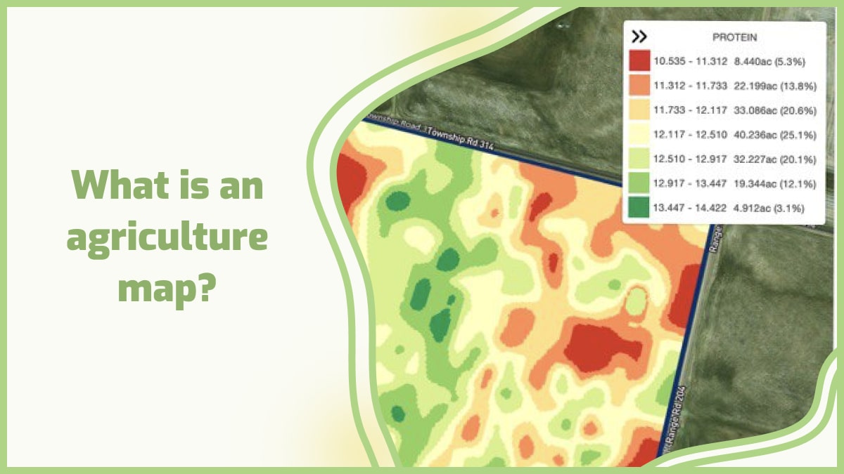
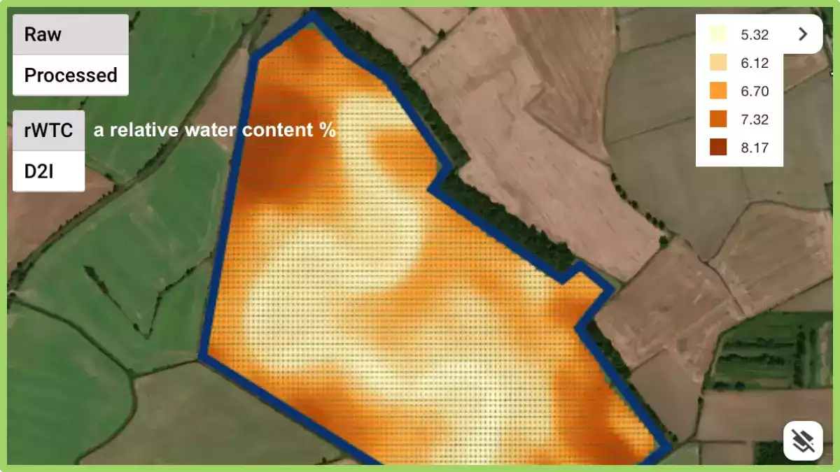
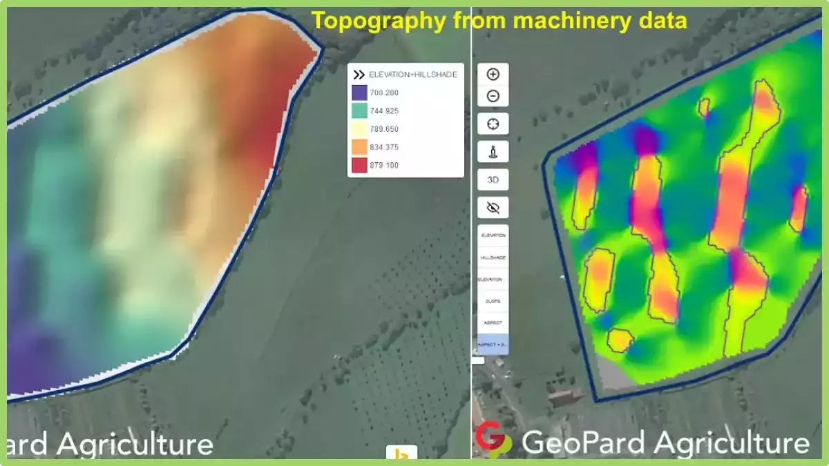
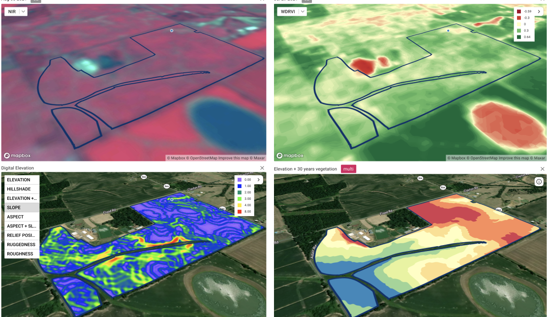
Here is how drone mapping works: a drone is mounted with sensors such as cameras and laser scanners that fly over an area capturing images or scanning it with lasers at various altitudes and angles. The collected data is then processed into 3D maps which can be viewed on a computer or smartphone screen.

The function of drones for agriculture

Here are some of the functions of drones for agriculture: 1. Mapping with drone for Farm Planning One major advantage that drone survey provide to farmers is accurate mapping information. This helps them plan their crops better and achieve higher yields through proper crop rotation. The main benefit of drones is that they allow farmers to save time by helping them plan out so many things from their harvests to their fertilization schedules. There are many uses for mapping with drones and some of the most common ones are:
  • Finding crop stressors like pests, weeds, and diseases.
  • Mapping fields for irrigation or fertilizer use.
  • Checking for drainage issues or erosion.
2. Multispectral Imagery Multispectral imagery is an important tool for farmers. One of the key uses of drones in agriculture is to provide farmers with information about the health of their crops. Multispectral images can be used to assess plant health by measuring chlorophyll content, which indicates how much photosynthesis is occurring. Multispectral imagery has been used in agriculture for several years but the process was slow, expensive, and difficult to use. Now drone survey make it easier and cheaper than ever before. 3. Soil Analysis Drones can be used for a wide range of applications in agriculture. One of the most important uses is топырақ талдауы. Soil analysis is used to determine the nutrient levels in the soil, which can help farmers determine how much fertilizer they need to apply to their crops. If a crop is receiving too much or too little fertilizer, it will result in poor yield and quality. Using drone imaging for soil analysis allows farmers to get real-time feedback on their crop’s health and growth. This helps them make better decisions on when and how much fertilizer they need to use. 4. Crops Health Assessments (Scanning Crops with UAV Multispectral Technology) The use of drones for agriculture has many benefits. The most important is that it allows farmers to keep track of the state of health of their crops, allowing them to react quickly to any problems. This can be done through multispectral cameras attached to the drone. These cameras work by capturing images of the crops and analyzing them to determine if there are any deficiencies in the crop or not. The results can then be used by farmers to help them make decisions regarding their crops. For example, if there is too much nitrogen present in a certain area they may decide to reduce the amount of fertilizer they use in that area next year. This will help them produce larger yields and save money as well as protect the environment. 5. Livestock Tracking Livestock tracking is one of the most important functions of drones in agriculture. Drones can be used to track livestock and locate them if they are lost. Also, with the help of drone survey, you can easily track your livestock without having to physically check on them every now and then. Drones equipped with sensors will collect data about your animals such as their location, their health status, etc. This information can be used by farmers to determine if any animals need medical attention or if there is any threat to their security or safety. 6. Seed Planting Drones can be used to plant seeds at the optimal depth, distance apart, and speed for each seed type based on factors like soil type or weather conditions at planting time. This helps ensure every seed gets planted correctly so that every plant has the best chance of survival once it sprouts up through the ground. A drone can fly over acres of land within minutes, accurately spreading seed as well as monitoring its progress with sensors designed for this purpose. One of the major benefits of using a drone to plant seeds is that it allows farmers to save time and money. Farmers can also use drone survey to monitor their crops regularly throughout the growing season and make adjustments if necessary – such as adding fertilizer or water when necessary – before any damage occurs.

Innovative use of 3D drone mapping and imaging in modern agriculture

1. Terrain and Soil NDVI Mapping with drone  Agriculture Drone mapping allows you to measure salinity, топырақ түрі, and health in a matter of minutes. The elevations are visible in the accurate 3D maps that it can generate, which aid in soil research and seed and crop placement planning ahead of time. The data generated by the drone’s soil analysis report will show the status of the substrate and its requirements throughout the growing season, including individual water requirements and nitrogen management. Terrain and Soil drone Mapping 2. Prescription maps for fertilizers, herbicides, and pesticides with drone survey  Just one strategy is out of date, as it not only wastes resources, but it can also affect the health and vitality of crops. Too much water, for example, can kill an otherwise healthy crop by preventing its roots from absorbing oxygen, so even watering isn’t the best approach to growing flawless crops. The same is true for fertilizers; using the correct amount is critical for growth, as using too many causes burnt roots, which can destroy otherwise healthy plants. Drone mapping allows sprays to be splattered only where the problem exists, reducing waste of resources and the risk of harming healthy crops that do not require the same treatment. While humans would be unable to recognize the unique requirements of each plant in their crop, drone survey technology can do it in minutes. 3. Crop assessment At the touch of a button, scouting missions are launched; the drone departs the weatherproof charging station, collects data, and uploads it. The findings of the drone, as well as a study of its plant stress detection and the efficacy of any current treatments or amendments, can be used to adapt automated irrigation systems. With on-site scouting drones, constant health checks are possible. 4. Plant population count With the drone’s powerful AI technology, any variety of plants may be identified. This allows the entire production and total loss to be determined at the start and conclusion of each season, increasing precision and awareness of the growing season’s success. 5. Automatic classifications with drone imaging The drone imaging can tell what type of agricultural land it’s flying over, whether it’s arable, pastoral, or mixed. Drones may count the number of crops and livestock, as shown above, to verify that records are current and that any losses are noted. 6. Tracking crops Crop health isn’t predetermined because environmental factors might influence development. Temperature, humidity, nutritional and trace mineral content, insect and disease presence, water availability, and amounts of sun exposure are all elements to consider. All of these may be tracked using the drones’ different payloads, and many of these intangible variables can be handled by applying water or sprays directly to the needed regions. The healthier the crop’s surroundings, the stronger its immune system gets, and thus the healthier it becomes — with a far greater ability to ward off pests and diseases.

How to make a 3d map?

ГеоПард can help in creating 3d maps for agricultural aims. It is a unique software that allows you to create your 3D models from any existing geographic data or scratch. GeoPard has all the functions necessary to create 3D maps from satellite images and other sources of aerial photography. The software allows you to classify this data according to different criteria, including color, texture, shape, and height. GeoPard also allows users to control the placement of objects on a map or in an image with great accuracy. This means that users can move objects on a map by simply moving them on their computer screen. The program also comes with integrated tools for editing images and photogrammetry processing features. These features let users do things like changing the scale or orientation of an image or combining multiple images into one large photo. Users can also create new textures by adding details like shadows or noise effects to existing photos. GeoPard can be used by farmers, agronomists, ecologists, geographers, engineers, and all others who need to create 3D maps for agricultural aims. Farmers can use GeoPard to plan crop rotation and fertilization, determine areas with low fertility or high salinity, study soil erosion and landslides, and locate wells and water channels to avoid their contamination by pesticides.

Жиі қойылатын сұрақтар


1. How much area can a drone survey? The area that a drone can survey depends on various factors, including flight time, battery capacity, and regulatory restrictions. Generally, drones can cover several acres of land in a single flight, ranging from a few acres to hundreds of acres. The exact coverage area also depends on the altitude at which the drone is flown and the desired level of detail required for the survey. Advanced drones equipped with longer flight times and larger batteries can cover larger areas in a single flight, while smaller drones may require multiple flights to cover the same area. 2. What season do they fly the drones to analyze the crops? Drones can be flown to analyze crops throughout the growing season, but the timing may vary depending on the specific objectives. Generally, drones are flown during the vegetative stage, flowering stage, and maturation stage of the crops. Each stage provides different insights into crop health, growth patterns, and potential issues. For instance, early-season flights can help assess emergence and uniformity, while mid-season flights can detect nutrient deficiencies or pest infestations. Late-season flights can provide information on yield potential and harvest timing. Therefore, drone flights are conducted at various stages to capture a comprehensive understanding of the crop’s condition. 3. How to make money with a drone in the agriculture industry? There are several ways to make money with a drone in the agriculture industry. One option is to offer aerial imaging and mapping services, providing farmers with detailed aerial data for crop monitoring, field analysis, and yield estimation. Another avenue is to provide crop health assessment services, using specialized sensors to identify issues such as nutrient deficiencies, pest infestations, or irrigation problems. Additionally, offering drone-based spraying services for precision application of fertilizers or pesticides can be lucrative. Lastly, offering drone training and consultancy services to help farmers integrate drones into their operations can also be a profitable venture. 4. How much to charge for drone mapping? The pricing for drone mapping services varies depending on several factors. These include the size and complexity of the area to be mapped, the resolution and level of detail required, and the specific deliverables needed. It is common for drone mapping services to be priced per acre or per hour, with rates typically ranging from $100 to $500 per hour. However, it is best to consult with professional drone mapping service providers to obtain accurate and tailored pricing information for your specific project. 5. What is geomapping? Geomapping, also known as geographic mapping or spatial mapping, is the process of visualizing and representing geographic data on a map. It involves collecting, analyzing, and displaying various types of information such as locations, boundaries, terrain features, and infrastructure. Geomapping allows us to understand and explore relationships between different data points in a spatial context, enabling better decision-making and planning in areas like urban development, environmental management, and navigation. It is a powerful tool used in various fields including cartography, geography, urban planning, and resource management. 6. How to survey land with smartphone? Surveying land with a smartphone can be achieved using various apps and techniques. Firstly, download a reliable surveying app that utilizes the phone’s built-in GPS capabilities. Next, ensure the phone has a stable internet connection and enable location services. With the app open, follow the on-screen instructions to mark specific points, measure distances, and record relevant data. It is important to maintain accuracy by using additional tools like tripods or external GPS receivers if necessary. Always refer to professional surveyors for complex or legal surveying requirements.

Пайдалануға жарамды ауыл шаруашылығы картасын қалай дайындауға болады?

Ауыл шаруашылығы біздің экономикамызға үлкен үлес қосады және біз оның осылай қалуын қалаймыз. Сондықтан далада не болып жатқанын және оның әлемге қалай әсер ететінін түсіну маңызды. Ауыл шаруашылығы саласы дақылдарын өсіруге көмектесу үшін жылдар бойы карталарды пайдаланып келеді.

Олар оларды дақылдарын қайда отырғызатынын, әр дақылдан қанша егу керектігін және әр дақылдан қанша ақша таба алатынын жоспарлау үшін пайдаланады. Ауыл шаруашылығы картасын пайдаланған кезде, оны қалай оқу керектігін және қандай ақпарат беретінін түсіну маңызды.

Картада басқаша көрсетілген топырақ түрлері және олардың құнарлылық деңгейлері, сондай-ақ аймақтағы әртүрлі өсімдіктер түрлері. Бұл ақпарат фермерлерге топырақ түрлері мен құнарлылық деңгейіне байланысты өз егістіктерінің қай жерде орналасқанын және қандай дақылдар отырғызу керектігін анықтауға көмектеседі.

Сонымен қатар, жақсы карта оқуға және түсінуге оңай болуы керек. Ол сондай-ақ дәл, егжей-тегжейлі және жаңартылған болуы керек.

Ауыл шаруашылығы картасын қалай дайындау керектігі туралы бірнеше кеңестер:

1. Негізгі қабат ретінде аэрофотосурет пайдаланыңыз. Бұл басқа қабаттар үшін визуалды сілтеме береді және өріс шекараларымен дәлдікті жақсартуға мүмкіндік береді.

2. Картада қолданылған барлық белгілерді және олардың мағынасын қамтитын белгілердің аңызын жасаңыз. Барлық белгілеріңіздің әртүрлі түстерді, пішіндерді немесе өрнектерді пайдалану арқылы бір-бірінен оңай анықталатынына көз жеткізіңіз.

3. Ғимараттарға, жолдарға немесе сәйкестендіруді қажет ететін басқа да нысандарға анық белгілерді қолданыңыз. Әрбір белгінің сәйкес нысанның үстінде орналасқанына көз жеткізіңіз, сонда пайдаланушылар картадағы орналасқан жерін оңай таба алады.

4. Барлық мәтіннің экраннан немесе картаңыздың қағаз нұсқасынан алыс қашықтықта оңай оқылатындай етіп жеткілікті үлкен екеніне көз жеткізіңіз. Бұл біреу далада жұмыс істеп немесе жерді басқару тәжірибелері туралы шешім қабылдап жатқанда қарап отырған нәрсесін түсіндіруге тырысқан кезде кез келген шатасуды немесе қате оқуды болдырмауға көмектеседі.

Неліктен бізге ауыл шаруашылығы картасы қажет?

Мұның көптеген себептері бар.

1. Фермерлер өз жерлерінің қайда орналасқанын білуі керек. Олар сондай-ақ өз шекараларын және көршілерінің кім екенін білуі керек. Фермер бұл ақпаратты өз жерінде су немесе минералдар сияқты пайдалы болуы мүмкін табиғи ресурстардың бар-жоғын білу үшін пайдалана алады.

2. Үкіметтер мектептер мен ауруханалар сияқты мемлекеттік қызметтерді жоспарлау үшін ауылшаруашылық жерлерінің орналасқан жерін білуі керек.

3. Үкіметтер ауыл шаруашылығынан қанша ақша түсетінін білгісі келеді, осылайша олар алдағы жылдары саланы жақсартуға қанша қаражат жұмсау керектігін шеше алады.

4. Ауыл шаруашылығы картасы сонымен қатар сіздің фермаңыздың аймағыңыздағы басқа фермалармен қалай салыстырылатынын көруге мүмкіндік береді және аймақта қандай дақылдар жақсы өсетіні туралы түсінік береді.

5. Ауыл шаруашылығы картасын пайдалану сізге ауыспалы егістерді жоспарлауға және қолжетімді жердің әрбір акрына қай дақылдар ең көп пайда әкелетінін анықтауға көмектеседі.

Ауыл шаруашылығында егістік картаға түсіру дегеніміз не?

Егістік картаға түсіру - жеріңізді картаға түсіру үшін GPS технологиясын пайдалану процесі. Оны фермерлер мен агробизнес өкілдері өз егістіктері мен дақылдары туралы, мысалы, олардың қаншалықты өсірілгені немесе қаншалықты құнарлы екендігі туралы ақпарат жинау тәсілі ретінде пайдаланады.

Далалық картаға түсіру сіздің жеріңіз туралы дәл ақпараттың болуын қамтамасыз ету үшін нақты уақыт режиміндегі GPS технологиясын пайдаланады. Бұл дәстүрлі геодезиялық әдістерден ерекшеленеді, себебі ол геодезистті немесе геодезиялық салада нақты дағдылары бар кез келген басқа адамды қажет етпейді.

Оның орнына, барлық жұмыс сіздің меншігіңіздің үстінен ұшып өтетін және оны жоғарыдан суретке түсіретін дрондардағы немесе спутниктердегі камералар мен сенсорларды пайдалану арқылы автоматты түрде орындалады.

Ауыл шаруашылығындағы егістік картаға түсіру

Содан кейін бағдарламалық жасақтама сол суреттерді сіз мүлікті алғаш сатып алған кезде түсірілген ескі суреттермен салыстырады, осылайша олардың арасындағы айырмашылықты есептей алады.

Далалық карталар әдетте аэрофотосуреттер немесе спутниктік суреттерді пайдаланып жасалады. Далалық карталардың ең көп таралған түрлеріне мыналар жатады:

  • Топырақ зерттеулері: Бұл карталар белгілі бір аумақтағы әрбір топырақтың орналасқан жері мен түрін көрсетеді.
  • Ауыл шаруашылығы жерлерін пайдалану: Бұл карталарда белгілі бір аумақта қандай дақылдар өсірілетіні және олар бір гектардан қанша өнім беретіні көрсетілген.
  • Ауыспалы егіс: Бұл карталар белгілі бір аумақта уақыт өте келе әртүрлі дақылдардың қаншалықты жиі өсірілетінін көрсетеді. Сондай-ақ, олар қай дақылдардың басқа дақылдармен немесе қай дақылдардың бір-бірімен ауысып егілетінін көрсете алады.

Егістік карталарының фермерлер арасында соншалықты танымал болуының екі негізгі себебі бар:

1. Бұл оларға белгілі бір жер учаскесінен немесе дақылдан қанша өнім күтуге болатынын дәл бағалауға мүмкіндік береді.
2. Егістік карталарын жасау оларға белгілі бір тұқым түрлеріне немесе тыңайтқыштарға инвестиция салудың тиімді болатынын немесе болмайтынын шешуге көмектеседі.

Дәл ауыл шаруашылығы картасын жасау

Дәл ауыл шаруашылығы картасын жасау - бұл дақылдардың және басқа да ауыл шаруашылығы нысандарының орналасуын картаға түсіру үшін спутниктік және әуеден түсірілген суреттерді пайдаланатын ГАЖ (географиялық ақпараттық жүйелер) жиынтығы. Бұл ақпаратты фермерлер су мен тыңайтқышты қай жерге қолдану керектігін анықтау үшін пайдалана алады, бұл оларға ақша үнемдеуге және өнімділікті арттыруға көмектеседі.

Дәл ауыл шаруашылығы карталары сізге дақылдарыңыздың қай жерде ең жақсы және ең нашар өсіп жатқанын дәл көруге мүмкіндік береді. Бұл ақпаратты фермаңыздың әрбір бөлігіне қанша тыңайтқыш қолдану керектігін, сондай-ақ қанша су немесе пестицид қажет екенін бағалау үшін пайдалана аласыз.

Дәл ауыл шаруашылығы картасы сіздің фермаңыздағы ең жақсы және ең нашар топырақ жағдайларын дәл көрсетеді.

Дәл ауыл шаруашылығы картасын жасау

Дәл ауыл шаруашылығы картасын жасау үш негізгі бағытқа бағытталған:

1. Топырақ картасын жасау

Топырақ карталары егістікте немесе аумақта қандай топырақ түрлері бар екенін, сондай-ақ олардың сипаттамаларын (мысалы, ылғалдылық) көрсетіңіз. Фермерлер бұл ақпаратты белгілі бір аумақтарда қай дақылдар жақсы өсетінін анықтау үшін пайдаланады.

2. Су ресурстарын басқару

Су дақылдарды өсіру үшін қажет, бірақ тым көп немесе тым аз су өсімдіктердің өсуіне кері әсер етуі мүмкін. Дәл ауыл шаруашылығы картасын жасау фермерлерге көлбеу, топырақ түрі және дренаждық қуат сияқты факторларға сүйене отырып, өз егістіктеріне қанша су қажет екенін анықтауға көмектеседі. Бұл процесс егістіктерді шамадан тыс тыңайтқышпен немесе шамадан тыс суару арқылы пайда болатын қалдықтарды азайтуға көмектеседі.

3. Далалық деректерді жинау

Егістіктеріңізге қанша су қажет екенін анықтаудың ең жақсы жолы - егіс басталғанға дейін әр егістік туралы деректер жинау. Мұны әр аумаққа бөлек дрондармен ұшу немесе күн/жыл циклінің әртүрлі уақыттарында көліктерді әр егістік арқылы бірнеше рет жүргізу арқылы жасауға болады.

Ауыл шаруашылығына арналған ГАЖ карталары

Ауыл шаруашылығында ГАЖ карталары барған сайын маңызды бола түсуде. ГАЖ (Географиялық ақпараттық жүйелер) карталары фермерлер мен агробизнес субъектілеріне өз жерлерін, дақылдарын және малдарын жақсырақ түсінуге мүмкіндік береді.

ГИС карталарын фермерлер өз жерлерін қалай пайдалану керектігі туралы маңызды шешімдер қабылдау үшін пайдаланады. Фермерлер белгілі бір дақылдарды қайда өсіру керектігін, оларды қашан отырғызу керектігін және қашан жинау керектігін анықтау үшін ГИС карталарын пайдалана алады. Мұндай карталардың көмегімен фермерлер маусым бойы дақылдарына жеткілікті судың бар екеніне көз жеткізе алады.

Ауыл шаруашылығына арналған ГАЖ карталары сізге кірісіңізді арттыра алатын жаңа бизнес немесе өнімдерді жоспарлауға да көмектесе алады. Мысалы, егер сіз малды жайылымда өсіруден оларды бордақылау алаңдарында өсіруге ауысқыңыз келсе, сізге жақын жерде бордақылау алаңдары үшін қолайлы орындардың бар екенін көрсететін ГАЖ карталары қажет болады.

Ауыл шаруашылығы кәсіпорындары жаңа фермаларды қайда орналастыру керектігін анықтау үшін ГИС карталарын пайдаланады. Бұл кәсіпорындар белгілі бір аудандарда қандай дақыл түрлерінің тиімді болатынын анықтау үшін ГИС карталарын да пайдалана алады.

Ауыл шаруашылығын тиімдірек жүргізуді қалайтын фермерлер GPS немесе жерлерінен көбірек пайда алуға көмектесетін басқа да технология түрлеріне инвестиция салуды қалауы мүмкін. Фермерлер мен малшылар өз операцияларын тиімдірек және нәтижелі басқару үшін пайдаланатын ауыл шаруашылығына арналған ГАЖ карталарының көптеген түрлері бар. Оларға мыналар жатады:

Жерді пайдалану карталары – Бұлар белгілі бір аумақта жерді пайдаланудың әртүрлі түрлерінің бар екенін көрсетеді. Бұған ормандар, шабындықтар, батпақты жерлер және т.б. кіреді. Жерді пайдалану карталарын белгілі бір дақылдардың қай жерде өсірілетінін немесе малдың қай жерде үнемі өсірілетінін көрсету үшін де пайдалануға болады, осылайша фермерлер өз жерлерін тиімді және нәтижелі пайдаланып жатқанына көз жеткізе алады.

Топырақ карталары – Топырақ карталары белгілі бір аумақта қандай топырақ түрі бар екенін, сондай-ақ оның сипаттамаларын (мысалы, түсі) және басқа да сипаттамаларын (мысалы, рН) көрсетеді. Оларды фермерлер сол жердегі топырақ түріне байланысты белгілі бір аумақтарда қандай дақылдар жақсы өсетінін анықтау үшін пайдалана алады.

Ауыл шаруашылығына арналған ГАЖ карталарын көптеген жолдармен пайдалануға болады:

  • Ауа райына байланысты өсімдіктердің өсуін, дақылдардың пісіп жетілуін және топырақ жағдайын бақылау.
  • Малдың қайда екенін және оларға тамақтандыру немесе медициналық көмек қажет пе екенін білу үшін оларды бақылау.
  • Егіндерді кездейсоқ пестицидтермен немесе гербицидтермен бүркуден аулақ болу үшін жеріңіздегі дақылдардың қай жерде орналасқанын көрсететін карталар жасаңыз.
  • Фермаңыздың немесе ранчоңыздың айналасында қанша су бар екенін көрсету үшін. Құрғақ айларда жеуге шөп жеткіліксіз болған кезде жануарларыңызды сумен қамтамасыз ете алатын жақын маңдағы өзендер немесе көлдер бар-жоғын көре аласыз.
  • Шығындарды азайту және егін өнімділігін арттыру үшін.

Дәл картаға түсіру агробизнес мәселелерін қалай шешеді?

Дәл картаға түсіру шешімдері бүкіл әлемдегі фермерлер мен агробизнеске қиындықтарды жеңуге көмектеседі. Өнімділікті бақылаудан және топырақты басқарудан бастап дәл егіншілікке дейін және дақылдарды қорғау, бұл шешімдер өсірушілерге өнімділікті арттыруға және ресурстарды пайдалануды оңтайландыруға мүмкіндік береді.

Дәл картаға түсіру шешімдері өсірушілерге мыналарға көмектеседі:

1. Тыңайтқыштарды пайдалануды оңтайландырыңыз

Фермерлер азот деңгейі төмен аймақтарды анықтау арқылы тыңайтқыштарды қолдану мөлшерін жақсарту үшін дәлдік карта деректерін пайдалана алады, бұл оларға қолданудың ең жақсы уақыты мен әдісі туралы неғұрлым хабардар шешім қабылдауға мүмкіндік береді.

2. Егістікті қорғауды жақсарту

Агрономдар жәндіктердің зақымдануы мүмкін аймақтарды анықтау үшін дәл картаға түсіру деректерін пайдалана алады, бұл оларға зиянкестермен күресу шараларын ең тиімді болатын жерлерде жақсырақ мақсатты түрде жүргізуге мүмкіндік береді.

3. Судың бөлінуін бақылау

Су ресурстарын басқарушылар дәл картаға түсіруден және топырақ ылғалдылығын өлшеуден алынған ақпаратты егістіктер бойынша немесе жеке учаскелер ішіндегі судың таралуын бақылау үшін пайдалана алады, бұл дақылдардың өсу циклдерінің маңызды кезеңдерінде жеткілікті су алуын қамтамасыз етеді.

4. Өнімділікті арттыру

Дәл картаға түсіру фермерлерге дұрыс тұқымдарды дұрыс уақытта отырғызуды жеңілдету арқылы өнімділігін арттыруға көмектеседі, бұл оларға тыңайтқыштардың артық және жеткіліксіз болуы мәселелерін болдырмауға көмектеседі.

Сондай-ақ, бұл фермерлерге өз егістіктерінің суға деген қажеттіліктерін бақылауды жеңілдетеді, сондықтан олар әлі дайын емес немесе суы жеткілікті егістіктерді суаруға уақыт пен ақшаны жұмсаудың қажеті жоқ.

Бұл пайданы арттырады, себебі отын мен тыңайтқыш сияқты ресурстардың ысырап болуын азайтады, сонымен қатар тыңайтқыштардың шамадан тыс түсуіне жол бермеу және әрқашан оңтайлы ылғал деңгейін сақтау арқылы топырақ сапасын жақсартады.

5. Егін шығынын азайту

Дәл картаға түсіру фермерлерге зиянкестер немесе аурулардың өршуі сияқты ықтимал қауіптерді олар орын алмас бұрын анықтауды жеңілдету арқылы егін шығынын азайтуға көмектеседі, осылайша олар апат басталғанға дейін алдын алу шараларын қабылдай алады.

6. Жұмысшылар үшін қауіпсіздікті жақсарту

Дәл картаға түсіру технологиясын пайдалану жұмысшылар орындайтын тапсырмаларды жоспарлауды және талдауды жақсарту арқылы фермалардағы жарақаттар санын азайту арқылы өнеркәсіптік жұмысшылардың қауіпсіздігін жақсартуға көмектеседі.

7. Операциялық тиімділікті арттыру

Ауыл шаруашылығы кәсіпорындары жұмысшылардың қауіпсіздігіне, қоршаған ортаға әсерге және азық-түлік қауіпсіздігіне қатысты қатаң ережелерді сақтауы керек.

Дәл картаға түсіру компанияларға өз операцияларының қоршаған ортаға қалай әсер ететінін түсінуге көмектеседі, бұл өз кезегінде оларға дақылдарды қайда және қалай өсіретіні немесе мал өсіретіні туралы жақсырақ хабардар шешім қабылдауға мүмкіндік береді.

8. Тәуекелді азайту

Дәл картаға түсіру ықтимал тәуекелдер орын алмас бұрын оларды түсінуге мүмкіндік береді. Мысалы, егер фермер қатты жаңбыр немесе ауа райының күрт өзгеруі салдарынан су тасқыны болуы мүмкін екенін білсе, ол бұл ақпаратты тиісті жоспарлау үшін пайдалана алады. Бұл оған су тасқыны немесе басқа табиғи апаттардан туындайтын қымбат шығындардан аулақ болуға мүмкіндік береді.

9. Табыстылықты арттыру

Дәл картаға түсірудің дақыл өнімділігін уақыт өте келе талдап, оны фермаңыздағы әрбір егістіктің тарихи деректерімен салыстыру мүмкіндігінің арқасында сіз фермаңызда жақсартуды қажет ететін салаларды анықтай аласыз, осылайша кірістілікті арттыруға көмектесесіз.

Ауыл шаруашылығы жүйесінің тиімділігін арттыруға келгенде ауыл шаруашылығын картаға түсіру өте маңызды. Мұның басты себебі - фермерлерге өз шаруашылықтарынан қажетті дақылдарды немесе кез келген басқа өнімді өсіре алатын жерлерді анықтауға көмектеседі.

Бұл оларға ауыл шаруашылығынан түсетін табыс көздерін жақсартуға және қалалық жерлерде тұратын адамдарға көбірек азық-түлік өндіру үшін жеткілікті ресурстардың болуын қамтамасыз етуге көмектеседі.

ГеоПард фермерлер өз шаруашылықтары туралы барлық ақпаратқа, мысалы, олардың ағымдағы жағдайына, егін өнімділігіне және т.б. қол жеткізе алатын платформа құрды. Бұл ақпараттың барлығы бұлттық серверде сақталады, онда пайдаланушылар егістікке өздері шықпай-ақ смартфондар немесе ноутбуктар арқылы қол жеткізе алады.

GeoPard - фермерлер мен агробизнес субъектілеріне өз егістіктерінен деректерді жинауға және өңдеуге көмектесетін сенімді, пайдалануға оңай бағдарламалық өнім. Бағдарламалық жасақтама фермаларда, егістіктерде және кеңселерде жұмыс істейтін ауыл шаруашылығы мамандарының қажеттіліктерін қанағаттандыру үшін жасалған.

GeoPard мүмкіндіктері негізгі далалық деректерді жинаудан бастап, кеңейтілген картаға түсіру қолданбаларына дейін қамтиды. Бағдарламалық жасақтама сізге дақыл түрін, құнарлылық деңгейін, өнімділік бағалауларын және т.б. көрсететін деректер қабаттарымен пайдалануға болатын ауылшаруашылық карталарын оңай дайындауға мүмкіндік береді.

Сондай-ақ, ол құнарлылығы төмен немесе басқа да проблемалары бар аймақтарды анықтау үшін пайдаланылуы мүмкін топырақ карталарын талдауға арналған бірнеше құралдарды ұсынады.

Геопроспекторлар / TopsoilMapper деректерін талдаңыз

GeoPard әртүрлі ауылшаруашылық кеңістіктік деректерін өңдей және талдай алады. Бұл жоғары тығыздықты сенсорлық деректер жиынтығымен жұмыс істеудің мысалы болып табылады, ол үлкен кеңістіктік өзгергіштікпен қамтамасыз етіледі. Геопроспекторлар ЖШС

Түсірілген деректерді импорттағаннан кейін Топырақ картасы, көре аласыз 

  • салыстырмалы су мөлшері
  • тығыздау туралы ақпаратпен өзара әрекеттесу тереңдігі
  • 4 жинақталған тереңдіктегі электр өткізгіштігі
Салыстырмалы су мөлшері, шикі ұпайлар

Geopard сізге шикі мәндері және үздіксіз беті бар нүктелерді көруге мүмкіндік береді; әртүрлі деректер қабаттарын салыстырады; аймақтық топырақ сынамалары және VRA үшін топырақ аймақтарын белгілейді; TopsoilMapper деректерін GeoPard-та қолжетімді тарихи, ағымдағы өсімдіктер және биіктік сияқты деректермен бір аймақ картасына біріктіреді. 

Қабаттарды салыстырыңыз: өсімдіктер (WDRVI), аймақтар картасы (EC+биіктік), EC, тығыздау


Картада қисық сызық ретінде төменгі EC мәндері нені білдіретінін білгіңіз келе ме? Бұл жер астында көмілген ежелгі өзен арнасы.

Машина жасау деректеріне негізделген топография

A lot of data collected from the fields is not used by farmers and agronomists. As an example, almost any modern machinery has a GPS receiver which is capable of gathering elevation data, quite often accuracy is improved with Real-time kinematic (RTK). 

Most of this data is not actively used, because it is quite a time consuming to extract, clean, and process this information to acquire real value out of it. One of the GeoPard main idea is to decrease the complexity of data usage in Precision Agriculture. 

GeoPard is capable of automatically extracting high-accuracy elevation data from:

  • Yield datasets
  • EC/other sensors datasets

GeoPard utilized the best available topography dataset for every field, but, unfortunately, high-accuracy lidar data is not available for every location in the world. Therefore, a machinery data-based digital elevation model will be a perfect option and significantly improves knowledge about the field. 

Henceforth, as any data layer in GeoPard, you can create zones out of machinery elevation data with Zones Creator, use this data in the Zones Ops module (finding of overlappings among different datasets) and use it in Көпқабатты аналитика.

Note that it is also possible to compare remote sensing based VS machinery/RTK based topography models.

What are topographic equipment?

Topographic equipment refers to the specialized tools and instruments used in the field of topography, which is the study and mapping of the surface features of the Earth.

What are topographic equipment

These tools are designed to measure and record various aspects of the land’s topography, including elevation, slope, and contours. Here are some commonly used topographic equipment:

  • Total Station: A total station is an electronic surveying instrument that combines the functions of a theodolite (used for measuring horizontal and vertical angles) and an electronic distance meter (EDM) to measure distances. It is used for precise positioning and measuring angles and distances in topographic surveys.
  • GPS (Global Positioning System) Receiver: GPS receivers use signals from satellites to determine accurate positions on Earth’s surface. In topography, GPS receivers are used to establish control points and measure coordinates, which are crucial for creating accurate topographic maps.
  • Leveling Instrument: Leveling instruments, such as a dumpy level or digital level, are used to measure height differences or elevations between different points on the ground. They help in determining contours and slopes of the land.
  • LiDAR (Light Detection and Ranging): LiDAR is a remote sensing technology that uses laser light to measure distances and create detailed three-dimensional maps. It is commonly used in aerial or ground-based surveys to capture high-resolution elevation data.
  • Photogrammetric Equipment: Photogrammetry involves obtaining measurements from photographs. Specialized cameras, topographer machine, drones, or unmanned aerial vehicles (UAVs) equipped with high-resolution cameras are used to capture aerial images. Photogrammetric software is then used to process these images and extract topographic information.
  • Handheld GPS Devices: Handheld GPS devices provide accurate position data in real-time. They are portable and used for navigation, mapping, and data collection in the field.
  • Field Books and Measuring Tools: Field books are used by surveyors to record measurements, sketches, and notes during topographic surveys. Measuring tools like measuring tapes, ranging poles, and flagging tape are used for measuring distances and marking points of interest.

These are some of the essential topographic equipment used in the field. It’s important to note that technological advancements may introduce new tools or variations of existing equipment, so staying updated with the latest developments is recommended.

What is topographer machine?

A topographer machine, also known as a topographic surveying machine or a topographic mapping system, is a specialized tool used in agriculture for the precise measurement and mapping of the physical features of a field or agricultural land.

What is topographer machine in agriculture

It is designed to capture accurate elevation data and create detailed topographic maps that represent the terrain’s contours, slopes, and other essential characteristics.

The topographer machine typically consists of advanced surveying equipment, including Global Positioning System (GPS) receivers, laser scanners, LiDAR (Light Detection and Ranging) sensors, and onboard computers.

These components work together to collect precise location data and measure the elevation of various points across the agricultural land.

The machine is operated by agricultural professionals or trained technicians who deploy it in the field. As the topographer machine moves through the area, it uses GPS signals to determine its position and laser or LiDAR technology to measure the height of the terrain. The collected data is then processed and analyzed to create accurate topographic maps.

The generated topographic maps provide valuable information to farmers and land managers. They allow for better planning and management of agricultural activities, such as irrigation, drainage, and land leveling.

By understanding the topography of the land, farmers can optimize their farming practices, minimize soil erosion, and enhance overall crop productivity.

In conclusion, topographic equipment plays a vital role in accurately measuring and mapping the surface features of the Earth in the field of topography. The information gathered using these tools is crucial for creating detailed topographic maps, which in turn aid in effective land management, planning agricultural activities, and optimizing farming practices. 

wpChatIcon
wpChatIcon

    Тегін GeoPard демосын/кеңес беруді сұраңыз


    Батырманы басу арқылы сіз біздің келісесіз Жеке деректерді қорғау саясаты. Сіздің өтінішіңізге жауап беру үшін ол қажет.

      Жазылу


      Батырманы басу арқылы сіз біздің келісесіз Жеке деректерді қорғау саясаты

        Бізге ақпарат жіберіңіз


        Батырманы басу арқылы сіз біздің келісесіз Жеке деректерді қорғау саясаты