データに基づいた意思決定のための農業区域運営

異なる階層にわたるゾーンオペレーション

精密農業においては、圃場データの収集とデータに基づいた意思決定が不可欠です。多層分析の開発と各層間の依存関係の発見における次の段階として、新しいモジュール「ゾーンオペレーション」を導入します。. 

そこでは、過去の植生、地形(派生データを含む)、収量モニターのデータ、土壌データ、スキャナー、安定性マップなど、さまざまな農業ゾーンマップ間の依存関係を検索できます。これは、最も影響を受けている地域を特定し、圃場の不均一性の原因を理解する上で、大きな前進となります。. 

どのようにしてその地域を特定できますか? 

まず、相互調査したい圃場マップを選択します。レイヤー比較ビューは、分析対象となる特定の農業区域を定義するのに適した方法です。.

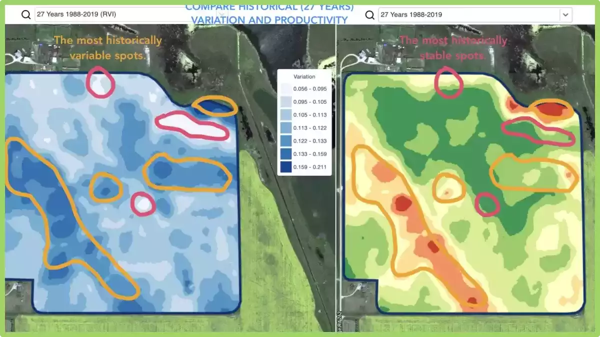
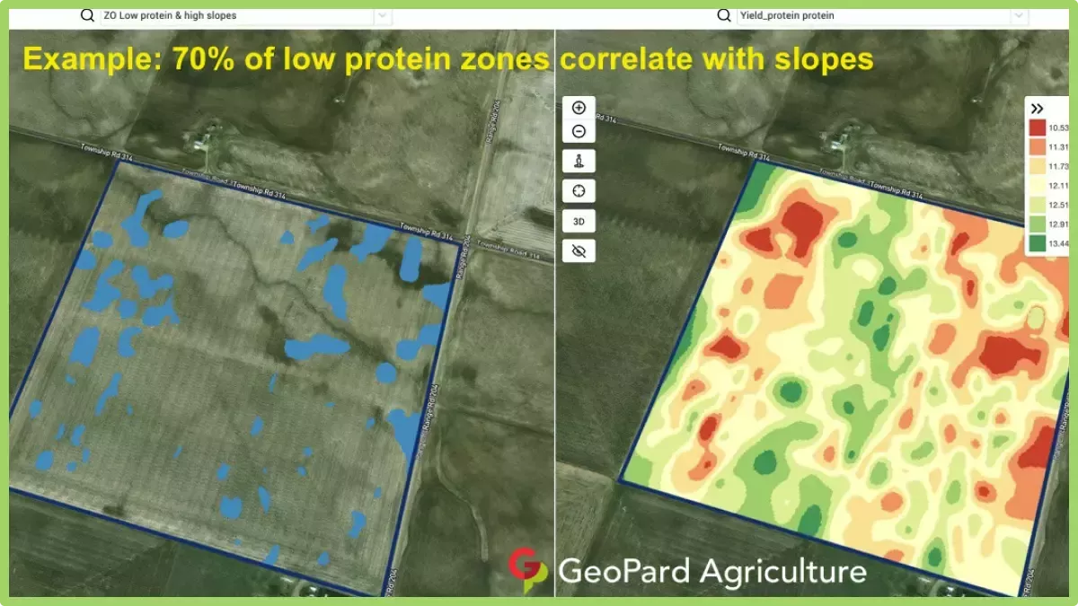
収量ポテンシャルが低い地域と傾斜地、最も不安定な地域と植生が低い地域、電気伝導率が低い地域と収量、施肥マップと現在の植生などを比較検討すると良いでしょう。.

次に、ゾーン操作モジュールで、比較したい各地図上に特定の農業ゾーンをマークします。最後に、関心のあるゾーンを取得します。なお、分析には2つ以上の地図を使用することも可能です。. 

この知識をどのように活用できますか? 

収量を説明するのに役立つ関係性を見つけることに加えて、特定の農業区域ごとに収量目標を設定したり、有望な地域を調査したり、そのような局所的な区域への投資を削減したり、制限要因を軽減する計画を立てたり、根本的な原因を把握した上で業績の低い区域を改善したり、VRA手法を用いて農学計画を策定したりすることが可能になります。. 

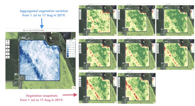
スクリーンショットには、フィールドインサイトの例がいくつか掲載されています。各フィールドは固有のものであり、以下の例が必ずしもお客様のフィールドで同じ結果を保証するものではありませんが、調査を開始する際の良い出発点となります。. 

ぜひこの投稿にコメントして、皆様の農業実践方法を共有してください。また、GeoPard Agricultureチームに直接ご連絡いただくことも可能です。私たちは、圃場のばらつきをより深く理解し、それを管理するためのソリューションを開発しているため、皆様からのフィードバックを歓迎いたします。.

ゾーン品質

ほぼすべて 管理区域が調整される 可変施肥マップを作成する前に、いくつかのゾーンを統合したり、既知の箇所を手動で修正したり、追加の緩衝エリアを追加したり、農業機械との互換性を確認したりといった作業が行われます。.

私たちGeoPardチームは、有効なポリゴンを用いた正確な自然管理区域が、区域の検証および修正プロセスにおいて多くの時間を節約できることを理解しています。.

GeoPardエンジン 以下のことを行います。

  • ノイズを自動的に除去し、,
  • 小さなポリゴンを最も近い大きなゾーンに自動的にマージします。,
  • 各ゾーンポリゴンには必要最小限のポイントのみを保持し、,
  • VRAマップをあらゆる農業機器や機械と互換性を持たせることができます。.

自動修正に加えて、, ゾーンを結合および分割するためのツール ご自身の現場知識や農作業の実践に合わせて地図を調整することができます。. 

市場には様々なプロバイダーから数多くの地図が出回っていますが、GeoPardの地図は間違いなく見覚えがあるはずです。.

農業における管理のためのゾーンの統合と分割

長年その分野に携わってきた農家や農学者ほど、その分野を熟知している人はいません。だからこそ、アルゴリズムに基づいた分析は、その分野に関する深い知識を持つ専門家によって検証・調整される必要があるのです。.

ゾーンの結合と分割機能を使用すると、プロフェッショナルはいくつかの重要な操作を行うことができます。 

  • ポリゴンを分割
  • ポリゴンを結合する
  • ポリゴンまたはゾーン全体を別のクラスに割り当てる

これらの調整はあらゆるデータレイヤーに適用でき、VR播種、施肥、散布などの精密農業作業に最適なゾーンを準備するのに非常に便利な機能です。.

農業における分裂とは何ですか?

農業において、分割とは、様々な管理方法を行うために、畑を複数の区画に分けることを指します。.

この区分けにより、農家はそれぞれの区画の具体的なニーズに基づいて、異なる処理方法や技術を適用することができる。.

例えば、農家は土壌の状態や作物の生育条件に応じて、異なる肥料、除草剤、灌漑方法を適用するために畑を分割することがあります。.

分割栽培は、資源を的確かつ効率的に活用することを可能にし、作物の生育を最適化し、コストを最小限に抑えると同時に、圃場のさまざまな領域における特定の課題に対処する。.

安定性と性能分析による作物管理


過去1~2週間、1~2ヶ月、あるいは数年間に圃場で起こった変化を検知することは、作物の生育状況に関する知見を得るのに役立ちます。.

これは以下の目的で使用できます。

  • 5年、10年、20年にわたって同様のパフォーマンスを示す場所を特定し、同様の条件の地域で試験を実施して、ミスの可能性を減らす。,
  • シーズン中の変化を追跡し、生育中の作物のパフォーマンスを評価する。,
  • 気象災害、疾病、害虫の被害後に被害を受けた地域を特定し、被害面積を計算する。,
  • 最後の2枚の画像間の差分を検出し、トリミング性能を制御する。.
地盤安定領域

そして、これらすべて、さらにはさらに多くのケースがGeoPardフィールド安定性ゾーンでカバーされます。特に、シーズン中および過去の管理ゾーンと組み合わせることで、より深い洞察が得られます。.

畑と衛星画像を選択するだけで、畑全体の変化を追跡し、作物を管理し、畑のあらゆる場所に関する洞察を得ることができます。.

現場の安定性ゾーンの選択

レイヤーの比較

GeoPard Agricultureソリューションを常に強化し、ユーザーにとっての価値を高めていることは周知の事実です。当社のウェブサイトの「近日公開」セクションをご覧ください。 https://geopard.tech 今後実装される機能について、いくつかイメージをつかむため。.

彼らの優先順位付けは難しい場合があります。ここでフィードバックと製品デモが役立ちます。したがって、私たちのソリューションを多くの参加者に提示することで、 ワールド・アグリテック ロンドンで開催されたサミットのおかげで、私たちは配信計画を調整し、わずか数日で新しいレイヤー比較機能をリリースすることができました。.

これはどのような機能ですか?分割画面で、現場の分析結果を並べて視覚的に比較できます。比較対象として、自然色または赤外線カラーの画像、植生ビューの画像、生育期または過去の管理区域など、あらゆる種類のレイヤーを選択できます。ズームイン/ズームアウトやマップの移動を行うと、2つのレイヤーは同期して動作するため、操作が簡単です。.

分割表示モードに入るには?フィールドを選択し、上部メニューの「レイヤー比較」アイコンをクリックします。分割表示画面で、上部にある検索可能なドロップダウンリストを使用して分析レイヤーを選択します。.

分割表示モードに入る
現場アナリストの選択
現場アナリストの比較

複数年ゾーン

それはどういう意味ですか? 過去の(複数年にわたる)管理区域は、30年以上にわたる衛星画像のアーカイブに基づいて構築されています。.

各季節において植生が最も旺盛な時期の画像は、分析の入力データとして自動的に選択されます。それ以外の場合、そのような画像はすべて、該当年の潜在的な収穫量を示すファイルとなります。.


過去の(複数年にわたる)管理区域は、現場のあらゆる場所に関する洞察を与えてくれる。.

どのように使えばいいですか? 畑作物の生育パターンを把握することで、農業地域をより深く理解し、適切な場所に適切な投入量で適切な意思決定を行うことが可能になります。.

過去の管理区域は、種まき、施肥、区域に基づいた土壌サンプリングのための処方箋(Rx)ファイルの設計図として使用できる。.

ご要望に応じて、すべての地域に対応いたします。.

複数年ゾーンとは何ですか?

精密農業における複数年ゾーンとは、圃場内で複数の生育期間にわたって作物の生育と収量に一貫した明確なパターンを示す特定の区域を指します。.

これらの区域は、リモートセンシング、GPSマッピング、土壌サンプリングなどの様々な技術を用いて特定される。.

これらの技術から収集されたデータを分析することで、農家や農学者は圃場内の変動パターンを特定し、生産性の高い地域と収量の低い地域を区別する地図を作成することができる。.

この情報は、植栽密度の変更、灌漑や施肥量の調整、さらには精密収穫技術の導入など、作物管理方法を最適化するために活用できる。.

これらは精密農業にとって貴重なツールであり、農家が資源配分や作物管理について十分な情報に基づいた意思決定を行うことを可能にし、結果として効率性の向上、コスト削減、収穫量の増加につながる。.

圃場内のばらつきを理解し、それぞれの地域に合わせた管理方法を採用することで、農家は土地と資源の潜在能力を最大限に引き出すことができる。.


Satellite Agriculture Monitoring For Field Analytics

What does it mean? GeoPard provides access to 30+ years of an archive of processed, calibrated, and cleaned satellite image data with comprehensive sets of views. The views are calculated against every satellite image in the blink of an eye. 

Deep in-season and historical field analytics is the basis of the GeoPard solution.

What is satellite agriculture monitoring?

Satellite agriculture monitoring refers to the use of satellite-based remote sensing technologies to gather information about agricultural crops and the land they are grown on.

This technology allows farmers and researchers to track crop growth, detect changes in vegetation health, measure the extent of land use, and monitor environmental conditions from a distance.

By analyzing satellite images, farmers can detect problems early, such as nutrient deficiencies, pests, and diseases, and take corrective actions before they cause significant damage to crops.

The data obtained from satellite imagery can also be used to optimize irrigation schedules, predict yield, and estimate crop production.

Satellite agriculture monitoring can provide valuable insights for agricultural management, allowing farmers to make more informed decisions and improve their yield and profitability.

It also plays an important role in food security and sustainability by enabling more efficient use of natural resources and reducing the environmental impact of agriculture.

How can you use satellite agriculture monitoring?

In near-real-time, you can monitor crop development including retrospective analysis and condition assessment, scout for areas with different levels of growth, detect anomalies and, for sure, compare your farm with neighboring fields and areas.

Further, it can be used in several ways to benefit farmers and researchers. Here are a few examples:

  • Crop monitoring: Satellite imagery can be used to monitor crop growth and development over time. By analyzing satellite images, farmers can track the health of their crops, identify areas of stress or disease, and adjust their management practices accordingly.
  • Yield prediction: Satellite data can be used to estimate crop yields based on vegetation indices, soil moisture, and other parameters. This information can help farmers make informed decisions about harvest schedules and marketing strategies.
  • Irrigation management: Satellite imagery can be used to monitor soil moisture levels and crop water use, allowing farmers to optimize their irrigation schedules and reduce water waste.
  • Soil mapping: Satellite imagery can be used to map soil properties such as texture, organic matter content, and nutrient availability. This information can help farmers make more informed decisions about fertilization and other soil management practices.
  • Pest and disease monitoring: Satellite imagery can be used to detect areas of pest and disease infestation, allowing farmers to take preventive measures before significant damage occurs.
  • Land use mapping: Satellite imagery can be used to map land use patterns and changes over time. This information can help policymakers and researchers better understand land use dynamics and develop more effective land use policies.

Overall, satellite agriculture monitoring provides a wealth of information that can help farmers and researchers make more informed decisions and improve agricultural productivity and sustainability.

精密農業における異質性因子の利用

One of the unique insights that GeoPard can provide is the Heterogeneity Factor of your fields.

それはどういう意味ですか? This number shows the level of heterogeneity/variability of your fields. The more variability field has – the more need for precisionag technologies. Especially, it is very useful in pair with GeoPard’s multi-year analytics (30-year history). 

What is Heterogeneity Factor?

Heterogeneity factor in precision agriculture refers to the variation in soil and crop characteristics within a given field. It can be caused by differences in topography, soil type, nutrient availability, water content, pest pressure, and other factors that affect plant growth.

In precision agriculture, the goal is to manage this by using site-specific information to apply inputs such as water, fertilizer, and pesticides at the right time and in the right amount to maximize crop yield and quality while minimizing environmental impact.

This requires the use of sensors, mapping technologies, and data analysis tools to create detailed maps of the field that can guide management decisions.

Its understanding is important because it can help farmers optimize their management strategies and increase their profitability.

By tailoring inputs to the specific needs of each area within a field, farmers can reduce input costs, increase crop yields, and improve overall crop health.

How you can use it?

If you have many fields, it can help you to understand, which fields to target first with Variable Rate Applications (seeding, fertilizing, spraying). 

By mapping the variations in soil and crop characteristics within a field, farmers can identify areas that have different needs and apply inputs at variable rates accordingly.

For example, areas of a field that have high nutrient availability may not need as much fertilizer as areas that have low nutrient availability. Similarly, areas of a field that have a high density of weeds may require more herbicide than areas with fewer weeds.

By using VRA, farmers can reduce input costs by applying inputs only where they are needed, and avoid over-application of inputs that can lead to environmental degradation.

This approach can also lead to higher crop yields and better quality crops, as inputs are tailored to the specific needs of each area within the field.

Therefore, understanding the heterogeneity factor in precision agriculture is crucial for making informed decisions about where to apply inputs and at what rates, ultimately leading to better management practices and increased profitability.

You save the most on chemicals on the most heterogeneous fields!

What is heterogeneity service?

In agriculture, it refers to the recognition and utilization of the natural variation or heterogeneity within a field or landscape. It involves understanding and leveraging the diverse characteristics of different areas to optimize agricultural practices.

The services can include precision agriculture techniques such as variable rate applications, site-specific management, and targeted interventions based on the specific needs of different zones or areas within a field.

By harnessing it, farmers can enhance resource efficiency, improve crop productivity, and minimize environmental impacts.

wpChatIcon
wpChatIcon

    無料GeoPardデモ・コンサルテーションをリクエスト


    ボタンをクリックすると、弊社の プライバシーポリシー. そのリクエストに返信するために必要です。.

      登録


      ボタンをクリックすると、弊社の プライバシーポリシー

        情報をお送りください


        ボタンをクリックすると、弊社の プライバシーポリシー