Agriculture is a major contributor to our economy, and we need it to stay that way. That’s why it’s important to understand what is happening in the field and how this affects the world. The agriculture industry has been using maps for years to help with growing their crops.
They use them for planning where they will plant their crops, how much of each crop they should plant, and how much money they can make from each crop. When using a farming map, it’s important to understand how to read it and what information it provides.
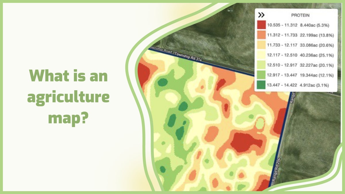
The map shows different soil types and their fertility levels, as well as different types of vegetation in an area. This type of information can help farmers determine where their fields are located and what kind of crops they should plant there based on soil types and fertility levels.
Also, a good map should be easy to read and understand. It should also be accurate, detailed, and up-to-date.
Here are some tips on how to prepare a usable agriculture map:
1. Use an aerial photograph as the base layer. This will provide a visual reference for other layers and allow for improved accuracy with field boundaries.
2. Create a symbol legend that includes all of the symbols used in the map, along with their meaning. Make sure that all of your symbols are easily identifiable from one another by using different colors, shapes, or patterns.
3. Use clear labeling on any buildings, roads, or other features that need identification. Make sure each label is located directly above its corresponding feature so it’s easy for users to find where they are located on the map.
4. Make sure all text is large enough so it can be read easily from a distance away from the screen or paper printout of your map. This will help avoid any confusion or misreading when someone is trying to interpret what they’re looking at while they’re working in the field or making decisions about their land management practices.
Why do we need an agriculture map?
There are many reasons for this.
1. Farmers need to know where their land is located. They also need to know their boundaries and who their neighbors are. A farmer can use this information to find out if there are any natural resources on their land that might be useful, such as water or minerals.
2. Governments need to know the location of agricultural land so that they can plan public services such as schools and hospitals.
3. Governments want to know how much money comes from farming so they can decide how much they should spend on improving the industry in future years.
4. An agriculture map also allows you to see how your farm compares with other farms in your area and gives you an idea of what kinds of crops may grow well in the area.
5. The use of an agriculture map can help you plan crop rotations and determine which crops will provide the most money for each acre of land that you have available.
What is field mapping in agriculture?
Field mapping is the process of using GPS technology to map out your land. It is used by farmers and agribusinesses as a way to gather information about their fields and crops, such as how much they have grown or how fertile they are.
Field mapping uses real-time GPS technology to make sure that you have accurate information about your land. This is different from traditional surveying methods because it does not require a surveyor or any other person with specific skills in the field of surveying.
Instead, all of the work happens automatically using cameras and sensors on drones or satellites that fly over your property and take pictures of it from above.

The software then compares those images with older ones taken when you first purchased the property so that it can calculate how much difference there is between them.
Field maps are usually created using aerial photos or satellite images. The most common types of field maps include:
- Soil surveys: These maps show the location and type of each soil in an area.
- Agricultural land use: These maps show which types of crops are grown in an area and how much they produce per acre.
- Crop rotation: These maps show how often different types of crops are grown in a particular area over time. They can also show which crops are rotated with other crops or which crops are rotated with each other.
There are two main reasons why field mapping is so popular among farmers:
1. It allows them to get an accurate estimate of how much produce can be expected from a certain area of land or crop.
2. Field mapping can help them decide whether or not it would be beneficial for them to invest in particular types of seeds or fertilizers.
Precision agriculture mapping
Precision agriculture mapping is a subset of GIS (geographic information systems) that uses satellite and aerial imagery to map the location of crops and other agricultural features. This information can be used by farmers to determine where they should apply water and fertilizer, which helps them save money and increase their yields.
Precision agriculture maps allow you to see exactly where your crops are growing at their best and worst. You can use this information to assess how much fertilizer you need to use on each section of your farm, as well as how much water or pesticides are needed.
A precision agriculture map shows you exactly where the best and worst soil conditions are located on your farm.

Precision agriculture mapping focuses on three major areas:
1. Soil mapping
Soil maps show what types of soil are present in a field or area, as well as their characteristics (such as moisture content). Farmers use this information to determine which crops will grow best in certain areas.
2. Water management
Water is necessary for growing crops, but too much or too little can negatively affect plant growth. Precision agriculture mapping helps farmers determine how much water their fields need based on factors such as slope, soil type, and drainage capacity. This process can help reduce waste from over-fertilizing or overwatering fields.
3. Field data collection
The best way to determine how much water your fields need is by collecting data about each field before planting begins. You can do this by flying drones over each area separately or by driving vehicles through each field multiple times during different times of day/year cycle.
GIS maps for agriculture
GIS maps are becoming increasingly important in the agricultural industry. GIS (Geographic Information Systems) maps allow farmers and agribusinesses to gain a better understanding of their land, crops, and livestock.
GIS maps are used by farmers to make critical decisions about how they use their land. Farmers can use GIS maps to determine where they should farm certain crops, when to plant them, and when to harvest them. With these types of maps, farmers can also make sure that they have enough water for their crops throughout the season.
GIS maps for agriculture can also help you plan for new businesses or products that could improve your bottom line. For example, if you want to make the switch from raising cattle on pastureland to raising them in feedlots, you’ll need GIS maps showing where there are suitable sites for feedlots nearby.
GIS maps are used by agribusinesses to determine where they should place new farms. These businesses can also use GIS maps to determine what types of crops will be profitable in certain areas.
Farmers who want to become more efficient with their farming may want to invest in a GPS or other types of technology that will help them get more out of their land. There are many types of GIS maps for agriculture that are used by farmers and ranchers to manage their operations more effectively and efficiently. These include:
Land use maps – These show where different types of land use exist within an area. This includes forests, grasslands, wetlands, etc. Land use maps can also be used to show where certain crops are grown or livestock is raised regularly so that farmers can make sure they’re using their land effectively and efficiently.
Soil maps – Soil maps show what type of soil is present in an area as well as its characteristics (such as color) and other characteristics (such as pH). These can be used by farmers to determine which crops grow best in certain areas based on the type of soil present there.
GIS maps for agriculture can be used in many ways:
- To monitor plant growth, crop maturity, and soil conditions as they relate to weather patterns.
- To keep track of livestock, so you know where they are at all times and whether they need feeding or medical attention.
- To create maps that show where crops are located on your property, so you can avoid accidentally spraying them with pesticides or herbicides.
- To show how much water is available around your farm or ranch. You can see whether there are any rivers or lakes nearby that could provide water for your animals during times when there isn’t enough grass available for them to eat in dry months.
- To reduce expenses and improve crop yields.
How does precision mapping solve agribusiness challenges?
Precision mapping solutions are helping farmers and agribusinesses across the globe to overcome their challenges. From yield monitoring and soil management to precision farming and crop protection, these solutions are enabling growers to increase productivity and optimize resource use.
Precision mapping solutions are helping growers to:
1. Optimize fertilizer use
Farmers can use precision mapping data to improve their fertilizer application rates by identifying areas where nitrogen levels are low, enabling them to make more informed decisions on the best time and method of application.
2. Improve crop protection
Agronomists can use data from precision mapping to identify areas where insect damage is likely to occur, allowing them to better target pest control treatments at locations where they will be most effective.
3. Monitor water distribution
Water managers can use information from precision mapping and soil moisture probes to monitor water distribution across fields or within individual plots, ensuring that crops receive enough water at critical times during growth cycles.
4. Increasing yields
Precision mapping helps farmers increase their yields by making it easier to plant the right seeds at the right time, helping them avoid over-fertilization and under-fertilization problems.
It also makes it easier for farmers to follow their fields’ water needs, so they don’t have to waste time and money watering fields that aren’t ready yet or that already have enough water.
This increases profits because it reduces wasted resources like fuel and fertilizer while improving soil quality by avoiding over-fertilization and maintaining ideal moisture levels at all times.
5. Reducing crop loss
Precision mapping also helps farmers reduce crop loss by making it easier for them to identify potential hazards like pests or disease outbreaks before they happen, so they can take preventative measures before disaster strikes.
6. Improved safety for workers
Using precision mapping technology helps improve the safety of industrial workers by reducing the number of injuries on farms through improved planning and analysis of tasks performed by workers.
7. Improving operational efficiency
Agribusinesses must comply with strict regulations regarding worker safety, environmental impact, and food safety.
Precision mapping can help companies understand how their operations impact the environment, which in turn allows them to make better-informed decisions about where and how they grow crops or raise livestock.
8. Minimizing risk
Precision mapping offers insights into potential risks before they occur. For example, if a farmer knows that flooding is likely due to heavy rainfall or a sudden change in weather patterns, he can use this information to plan accordingly. This allows him to avoid costly damages caused by flooding or other natural disasters.
9. Increasing profitability
With precision mapping’s ability to analyze crop yield over time and compare it with historical data for each field on your farm, you’re able to identify areas that need improvement in your farm thus helping you increase profitability.
Agricultural mapping is a very important thing when it comes to improving the efficiency of the agriculture system. The main reason for this is because it helps farmers identify the areas where they can grow crops or any other product that they need from their farms.
This helps them to improve their source of income from farming and make sure that they have enough resources available so that they can produce more food for consumption for people living in urban areas.
GeoPard has created a platform where farmers can get access to all sorts of information regarding their farms, such as their current condition, crop yield, etc. All this information will be stored on a cloud server where users can access it through smartphones or laptops without having to go out into the fields themselves.
GeoPard is a robust, easy-to-use software product that helps farmers and agribusinesses to collect and process data from their fields. The software has been designed to meet the needs of agricultural professionals working on farms, in fields, and in offices.
GeoPard’s capabilities range from basic field data collection to advanced mapping applications. The software allows you to easily prepare usable agricultural maps with your data layers that show crop type, fertility levels, yield estimates, etc.
It also provides several tools for analyzing soil maps which can be used to identify areas with low fertility or other problems.