Geoinformatics (GIS) bridges the gap between spatial data and agriculture decision-making, allowing farmers to optimize resource utilization while minimizing environmental impact. This technology-driven approach helps tailor precision agriculture practices to specific field conditions, thus increasing productivity and efficiency.
Geoinformatics in Agriculture
By analyzing precise spatial information, such as soil variability, moisture content, and pest distribution, farmers can make well-informed choices, ensuring that each area of their land receives the exact treatment it requires.
Recent data shows that this technology is widely used, with over 70% of farms using it in some capacity. Geospatial data integration is becoming a standard practice in decision-making processes across a range of industries, from small-scale subsistence farming to major commercial operations.
Farmers are able to keep an eye on their crops in real time using satellite photography and ground sensors. With less waste and a smaller negative influence on the environment, they may use this to apply water, fertilizer, and pesticides precisely where and when they are needed.
The CottonMap project in Australia uses geoinformatics to monitor water use, resulting in a 40% decrease in water consumption. Enhanced resource management minimizes environmental impact by reducing chemical runoff and over-irrigation.

Increased productivity aids global food security. By optimizing planting patterns using spatial data, farmers can achieve higher crop yields without expanding agricultural land.
What is Geoinformatics?
Geoinformatics, also known as geographic information science (GIScience), is a multidisciplinary field that combines elements of geography, cartography, remote sensing, computer science, and information technology to gather, analyze, interpret, and visualize geographical and spatial data.
It focuses on capturing, storing, managing, analyzing, and presenting spatial information in digital forms, contributing to a better understanding of the Earth’s surface and the relationships between various geographic features. It is a powerful tool that can be used for a variety of purposes, including:
1. Precision agriculture: It can be used to collect data on a variety of factors, such as soil type, crop yield, and pest infestation. This data can then be analyzed to identify areas of variability within a field. Once these areas have been identified, farmers can use GIS to develop customized management plans for each area.
2. Environmental monitoring: It can be used to monitor changes in the environment, such as deforestation, land use change, and water quality. This data can then be used to track the progress of environmental policies and to identify areas that need further protection.
3. Urban planning: Geoinformatics can be used to plan and manage urban areas. This data can be used to identify areas that are in need of development, to plan transportation networks, and to manage infrastructure.
4. Disaster management: It can be used to manage disasters, such as floods, earthquakes, and wildfires. This data can be used to track the progress of a disaster, to identify areas that have been affected, and to coordinate relief efforts.

Components of Geoinformatics
These components work together to provide insights into various aspects of the Earth’s surface and its relationships. Here are the main components of geoinformatics:
- Geographic Information Systems (GIS): GIS involves the use of software and hardware to collect, store, manipulate, analyze, and visualize geographic data. This data is organized into layers, allowing users to create maps, conduct spatial analysis, and make informed decisions based on spatial relationships.
- Remote Sensing: Remote sensing involves the collection of information about the Earth’s surface from a distance, typically using satellites, aircraft, or drones. Remote sensing data, often in the form of imagery, can provide insights into land cover, vegetation health, climate patterns, and more.
- Global Positioning Systems (GPS): GPS technology enables accurate positioning and navigation through a network of satellites. In GIS, GPS is used to collect precise location data, which is crucial for mapping, navigation, and spatial analysis.
- Spatial Analysis: It enables the application of various spatial analysis techniques to understand patterns, relationships, and trends within geographic data. These techniques include proximity analysis, interpolation, overlay analysis, and network analysis.
- Cartography: Cartography involves the creation of maps and visual representations of geographic data. It provides tools and methods to design informative and visually appealing maps that effectively communicate spatial information.
- Geodatabases: Geodatabases are structured databases designed to store and manage geographic data. They provide a framework for organizing spatial data, allowing for efficient storage, retrieval, and analysis.
- Web Mapping and Geospatial Applications: Geoinformatics has expanded into web-based mapping and applications, allowing users to access and interact with geographic data through online platforms. This has led to the development of various location-based services and tools.
- Geospatial Modeling: Geospatial modeling involves the creation of computational models to simulate real-world geographic processes. These models help predict outcomes, simulate scenarios, and aid decision-making in various fields.
8 Applications and Uses of Geoinformatics in Agriculture
Here are some of the key applications and uses of GIS in agriculture:
1. Precision Farming
Precision Agriculture harnesses the power of Geographic Information Systems (GIS) to provide farmers with intricate insights into their fields. These insights range from detailed vegetation and productivity maps to crop-specific information.
The heart of this approach lies in data-driven decision-making, empowering farmers to optimize their practices for maximum yield and efficiency.

Through the generation of productivity maps, GeoPard Crop Monitoring provides a crucial solution for Precision Agriculture. These maps make use of historical information from prior years, enabling farmers to identify productivity patterns throughout their farms. Farmers can identify fruitful and unproductive locations by using these information.
2. Crop Health Monitoring
The significance of monitoring crop health cannot be overstated. The well-being of crops directly impacts yields, resource management, and the overall health of the agricultural ecosystem.
Traditionally, manual inspection of crops across expansive fields was arduous and time-consuming. However, with the advent of advanced technologies like GIS and remote sensing, a transformative shift has occurred, enabling precision monitoring on an unprecedented scale.
Geoinformatics aids in the early detection of potential issues affecting crop health. By analyzing remote sensing data and satellite imagery, farmers can identify stressors like nutrient deficiencies or disease outbreaks, allowing for targeted interventions.
3. Crop Yield Prediction
By integrating historical data, soil composition, weather patterns, and other variables, It enables farmers to predict crop yields with remarkable accuracy. This information empowers them to make informed decisions regarding planting, resource allocation, and marketing strategies.

In the field of predicting crop yields, GeoPard has become a leading innovator. GeoPard has developed a trustworthy method that claims an excellent accuracy rate of over 90% by combining historical and current crop data obtained from satellites. This innovative approach is proof of how technology may revolutionize contemporary agriculture.
4. Livestock Monitoring With Geoinformatics
Spatial data from GPS trackers on livestock offers insights into animal movements and behavior. These tools empower farmers to pinpoint the exact location of livestock within the farm, ensuring efficient management and care.
Beyond location tracking, GIS agriculture tools provide a comprehensive view of livestock health, growth patterns, fertility cycles, and nutritional requirements.
The global market for precision agriculture, which includes livestock monitoring, is projected to reach a substantial valuation by the coming years. This trend underscores the transformative potential of GIS in optimizing livestock management.
5. Insect and Pest Control
Traditional methods, such as manual scouting of large fields, have proven both time-consuming and inefficient. However, the convergence of technology, specifically deep learning algorithms and satellite data, has brought about a revolution in pest detection and management.
Geoinformatics helps in creating pest distribution maps, enabling precise application of pesticides. By targeting specific areas, farmers can minimize chemical usage, reduce environmental impact, and protect beneficial insects.
GeoPard Crop Monitoring is an effective method for spotting a variety of threats, such as weed infestations and crop diseases. Potential issue regions are detected by the study of field-collected vegetation indices.
For example, a low vegetation index value in a particular location may be a sign of potential pests or diseases. This realization simplifies the procedure and eliminates the need for time-consuming manual reconnaissance of large fields.
6. Irrigation Control
GIS-driven data provides valuable insights into soil moisture levels, helping farmers make informed decisions regarding irrigation scheduling. This ensures water efficiency and prevents overwatering or drought stress.

GIS technology for agriculture provides a potent toolbox for spotting crops that are under water stress. Farmers can learn more about the water state of their crops by using indices like the Normalized Difference Water Index (NDWI) or the Normalized Difference Moisture Index (NDMI).
The default component of GeoPard Crop Monitoring, the NDMI index, offers a scale from -1 to 1. Water shortages are indicated by negative values around -1, but waterlogging may be indicated by positive values close to 1.
7. Flooding, Erosion, and Drought Control
Flooding, erosion, and drought represent formidable adversaries that can inflict substantial damage on agricultural landscapes. Beyond physical destruction, these challenges disrupt water availability, soil health, and overall crop productivity. Effectively managing these threats is pivotal to ensuring food security, preserving natural resources, and fostering sustainable farming practices.
Geoinformatics aids in assessing landscape vulnerabilities to flooding, erosion, and drought. By analyzing topographical data, rainfall patterns, and soil characteristics, farmers can implement strategies to mitigate these risks.
8. GIS in Farming Automation
Geographic Information Systems (GIS) have transcended their traditional role as mapping tools to emerge as critical enablers in guiding automated machinery. This technology empowers various agricultural equipment, such as tractors and drones, with spatial data and precision navigation systems.
As a result, tasks that range from planting to spraying and harvesting can be executed with unprecedented accuracy and minimal human intervention.

Imagine a scenario where a tractor is tasked with planting crops across a vast field. Equipped with a GPS system and GIS technology, the tractor utilizes spatial data to navigate along predetermined routes, ensuring consistent seed placement and optimal spacing. This precision not only enhances crop yield but also minimizes resource wastage.
Role of Geoinformatics in Precision Agriculture
It plays a critical role in precision agriculture by providing farmers with the data and tools they need to make informed decisions about crop management. It can be used to collect data on a variety of factors, such as soil type, crop yield, and pest infestation.
This data can then be analyzed to identify areas of variability within a field. Once these areas have been identified, farmers can use GIS to develop customized management plans for each area.
The use of geoinformatics in precision agriculture is growing rapidly around the world. In the United States, for example, the use of precision agriculture has increased by more than 50% in the past five years. And in China, the use of precision agriculture is expected to grow by more than 20% per year in the coming years.
Studies have revealed that precision application of inputs through Geoinformatics techniques can lead to yield increases of up to 15% while reducing input costs by 10-30%.
Furthermore, a study published in the journal Nature in 2020 found that using GIS to manage water irrigation in a wheat field resulted in a 20% increase in crop yield. Another study, published in the journal Science in 2021, found that using GIS to apply fertilizer more precisely in a corn field resulted in a 15% increase in crop yield.
It can also be used to create maps of crop yield. These maps can be used to identify areas of low yield, which can then be investigated to determine the cause of the problem. Once the cause of the problem has been identified, farmers can take corrective action to improve yields in those areas.

For example, farmers can use it to create maps of soil type and fertility. These maps can then be used to target fertilizer applications more precisely, which can help to improve crop yields and reduce the amount of fertilizer that is applied unnecessarily.
In addition to collecting and analyzing data, it can also be used to visualize spatial data. This can be helpful for farmers to see how different factors, such as soil type and crop yield, are distributed across a field. Visualization tools can also be used to help farmers communicate their findings to others, such as crop consultants or government officials.
The real-world applications of geoinformatics in precision agriculture are abundant. For instance, Variable Rate Technology (VRT) employs spatial data to deliver varying amounts of inputs like water, fertilizers, and pesticides across a field.
This approach ensures that crops receive the exact nutrients they need, optimizing growth and yield. In another instance, satellite imagery and drones provide valuable insights into crop health and disease detection, enabling prompt intervention.
GeoPard Crop Monitoring As An Example Of Agriculture GIS Software
It’s crucial to keep in mind that the GIS software used in agriculture can differ depending on its intended use. While some tools indicate soil moisture levels to aid with planting selections, others display crop varieties, yields, and distributions.
Even comparing the economics of logging against forestry can be done with the use of various applications. Each farmer or agriculture manager must therefore discover the ideal GIS solution that provides them with the information they need to make wise decisions on their land.
When it comes to field data, GeoPard’s Crop Monitoring platform has a number of advantages. It offers summaries of vegetation and soil moisture dynamics, historical vegetation and weather data, and precise 14-day weather forecasts.

This platform provides capabilities like scouting to organize activities and exchange real-time information, as well as a field activity log for planning and monitoring operations, so it offers more than just GIS-based data.
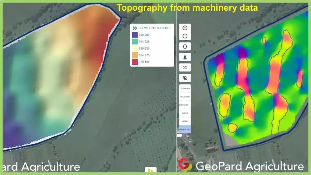
Data from additional sources is also included in GeoPard’s Crop Monitoring. The Data Manager tool, for instance, incorporates machine data into the platform. It supports popular file formats as SHP and ISO-XML.
You can measure crop yield using data from field machines, compare it to fertilizer maps, examine fertilizer tactics, and create plans to increase yield. The organizations that agricultural enterprises collaborate with and themselves benefit greatly from this all-in-one platform.
Challenges in Precision Agriculture and Geoinformatics
The integration of Precision Agriculture and Geoinformatics introduces a host of policy implications and regulatory considerations. Governments worldwide grapple with devising frameworks that foster innovation while safeguarding data privacy, land use, and environmental sustainability.
For instance, regulations may govern the collection and sharing of spatial data, intellectual property rights for precision farming technologies, and ethical use of AI in agriculture.
In the European Union, the Common Agricultural Policy (CAP) acknowledges the role of digital technologies, including Geoinformatics, in enhancing agricultural productivity.
Financial incentives are provided to encourage farmers to adopt precision farming practices that align with environmental and sustainability goals. This example illustrates how policy can drive technology adoption for collective benefit.
However, the adoption of geoinformatics technologies in agriculture presents significant benefits, yet it’s accompanied by challenges, particularly for farmers of varying scales. Small-scale farmers often face financial limitations, lacking the resources for technology acquisition and training.
Larger operations encounter data management complexities due to the scale of their activities. Technical knowledge gaps are common, with both small and large farmers requiring training to effectively utilize geoinformatics tools.
Limited infrastructure and connectivity hinder access, especially in remote areas. Customization struggles arise, as solutions may not fit small farms or integrate seamlessly into larger operations.
Cultural resistance to change and concerns over data privacy affect adoption universally. Government policies, ROI uncertainties, and interoperability issues further impede progress.
Addressing these challenges will demand tailored strategies to ensure that geoinformatics benefits all farmers, regardless of scale.
Conclusion
The seamless integration of Geoinformatics into modern agriculture holds transformative potential. By harnessing the power of spatial data, farmers and agricultural stakeholders can make informed decisions, optimize resource utilization, and foster sustainable practices. Whether it’s predicting crop yields, managing water resources, or enhancing precision agriculture, GIS emerges as a guiding light, shaping a more efficient, resilient, and productive future for the world of farming.
Precision Farming