Операције Зона Пољопривреде за Одлучивање засновано на Подацима

ZONES OPERATIONS ACROSS DIFFERENT LAYERS

In precision farming, field data collection and data-driven decision making are absolutely essential. As the next stage in the development of multi-layers analytics and finding dependencies across layers we introduce new module Zones Operations. 

There you can search for dependencies between different ag zones maps such as historical vegetation, topography including its derivatives, data from yield monitors, soil data, scanners, stability maps, and so on. This is a step forward in defining the most influenced areas and understanding the reasons for field heterogeneity. 

How can you identify the areas? 

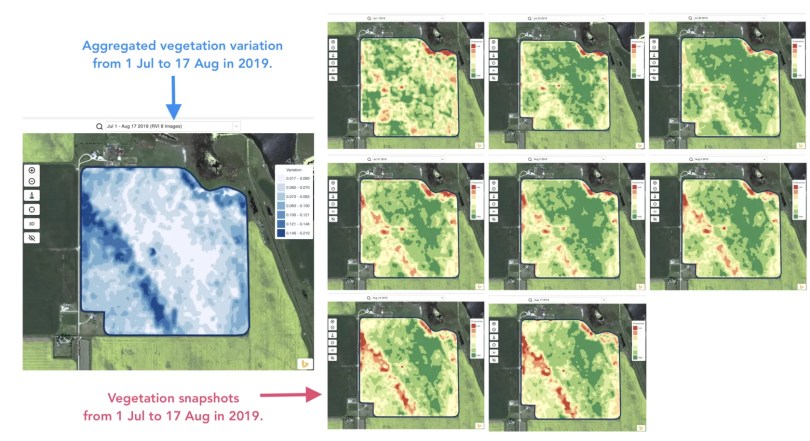
First of all select field maps, you want to cross-investigate. A layer comparison view is a good approach to define specific agriculture zones for analyzing.

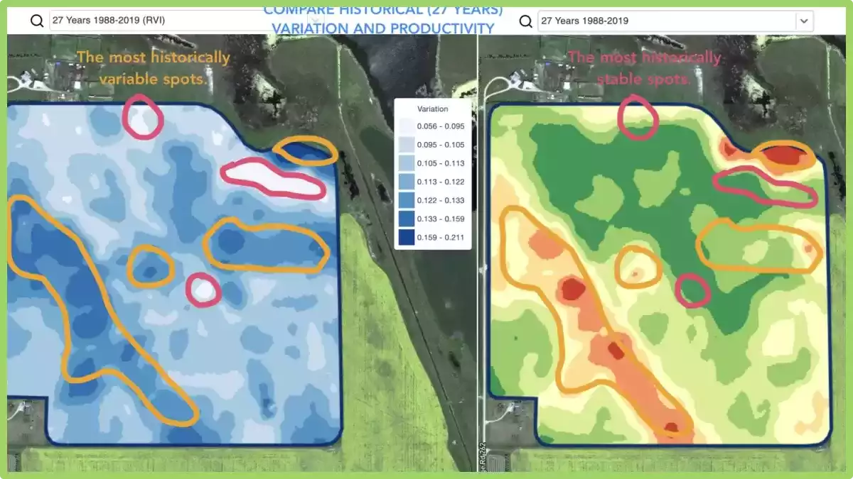
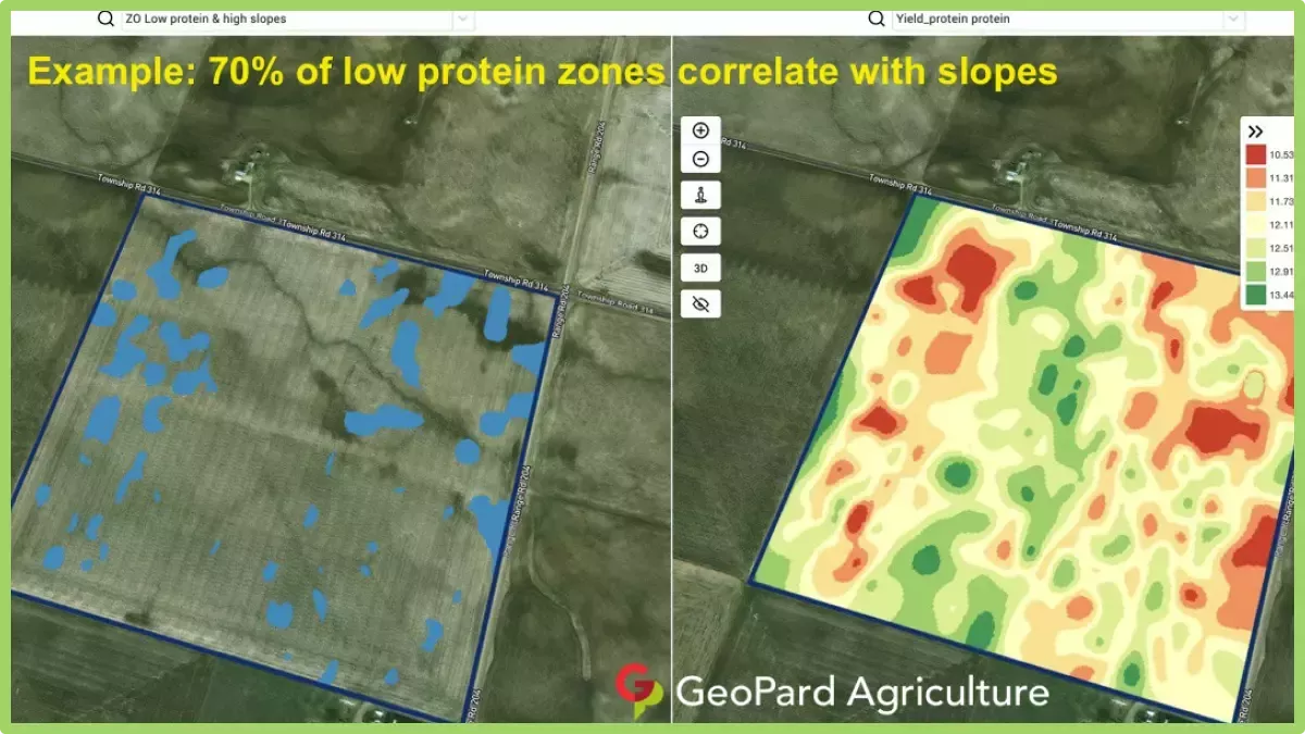
You may want to compare low yield potential and sloppy areas, most unstable zones and low vegetation, low electrical conductivity and yield, as applied fertilization map and current vegetation, and others.

Secondly, mark specific agriculture zones on every map you want to compare in the Zones Operations module. And finally, obtain a zone of interest. Note that it is possible to use more than two maps in analyses. 

How can you apply this knowledge? 

In addition to finding relationships that can help explain yield, it is possible to set yield goals for defined agriculture zones; to scout interesting areas; to reduce investments in such localized zones or build the plan of mitigating limiting factors and pull up underperforming areas knowing the underlying causes; to build agronomy plan using VRA practices. 

There are several examples of field insights on screenshots. Note that every field is unique and below-mentioned cases do not guarantee 100% same result for your field but it is a good way to start the investigation from. 

You are very welcome to share your agronomic practices by commenting on this post, contact the GeoPard Agriculture team directly. We are open to the feedback because we build the solution for you for a better understanding of field variability and managing it.

Зоне квалитета

Скоро сви зоне управљања се прилагођавају пре него што постане мапа примене променљиве стопе. То може бити спајање неких зона, ручне корекције на добро познатим местима, додавање додатних заштитних подручја, компатибилност пољопривредне опреме итд.

Ми, у GeoPard тиму, разумемо да ће прецизне зоне управљања природним ресурсима са валидним полигонима уштедети много времена током процеса верификације и корекције зона.

ГеоПардов мотор ради следеће:

  • аутоматски уклања буку,
  • аутоматски спаја мале полигоне у најближу већу зону,
  • задржава само неопходан минимални број тачака у сваком зонском полигону,
  • чини VRA мапе компатибилним са било којом пољопривредном опремом и механизацијом.

Поред аутоматске корекције, алат за спајање и раздвајање зона је доступно за прилагођавање мапе према вашем теренском знању и агрономској пракси. 

На тржишту постоји много различитих мапа од разних добављача, али ћете дефинитивно препознати GeoPard мапе.

Спајање и подела зона за управљање у пољопривреди

Nobody knows his field better than a farmer or agronomist who works with the field for many years. That’s why any algorithm-based analytics often needs to be validated and adjusted by a professional using his deep knowledge of the field.

Merge and split zones feature allows a professional to make a few important things: 

  • Split polygons
  • Merge polygons
  • Assign a polygon or a complete zone to another class

These adjustments can be applied for any data layer and it is a very useful feature to prepare YOUR perfect zones for precision ag operations like VR seeding, fertilizing or spraying.

What are splits in agriculture?

In agriculture, splits refer to the division or splitting of a field into different sections for various management practices.

This division allows farmers to apply different treatments or techniques to each section based on specific needs.

For example, farmers may split a field to apply different fertilizers, herbicides, or irrigation methods based on soil conditions or crop requirements.

Splits enable targeted and efficient application of resources, optimizing crop growth and minimizing costs while addressing specific challenges within different areas of the field.

Контрола усева са аналитиком стабилности и перформанси


Detecting changes that happened in the field during the last 1-2 weeks or 1-2 months or even a couple of years helps to get insights about crop development.

It can be used to:

  • locate spots with similar performance across the 5-10-20 years and place the trials in areas with similar conditions to reduce the probability of mistakes,
  • track the changes during the season and evaluate crop performance during the growth,
  • recognize the damaged areas after a weather disaster or a disease or a pest attack and calculate damaged areas,
  • detect the difference between the last 2 images and control the crop performance.
Field Stability Zones

And all that and even more cases are covered with GeoPard Field Stability Zones. Especially, it will provide more insights together in combination with in-season and historical management zones.

Simply choose your field and satellite images to track the changes across them, control crops, and get insights about every spot in your field.

selection of field stability zones

Поређење слојева

Није тајна да константно обогаћујемо решење GeoPard Agriculture и повећавамо његову вредност за кориснике. Само погледајте одељак “ускоро” на нашем сајту https://geopard.tech да добијете идеју о неким функцијама на путу.

Њихов приоритет може бити изазован. Овде у помоћ пристижу повратне информације и демо производи. Тако представљајући наше решење многим присућнима Светска агротехнологија На самиту у Лондону, успели смо да прилагодимо план испоруке и пустимо нову функцију поређења слојева за само неколико дана.

О чему се ради? Можете визуелно упоредити аналитику поља једна уз другу у приказаном подељеном погледу. Могуће је изабрати било који тип слојева за поређење: слике у природним или инфрацрвеним бојама, слике са приказом вегетације, зоне управљања у сезони или историјске. Два слоја се синхроно понашају када зумирате унапред/уназад или померате мапу ради вашег удобности.

Како ући у режим подељеног приказа? Одаберите своје поље и кликните на икону "Упореди слојеве" у горњем менију. На екрану подељеног приказа, изаберите аналитички слој помоћу падајуће листе са могућношћу претраживања која се налази на врху.

уђите у режим подељеног приказа
Избор поља аналитичара
поређење теренских аналитичара

Вишегодишње зоне

Шта то значи? Historical (multi-year) management zones are built based on 30+ years archive of satellite imagery.

Images with peak vegetation during every season are automatically selected as inputs for analytics. Otherwise, every such image represents a potential yield file for the related year.


Historical (multi-year) management zones provide insights about every spot in the field.

How can you use it? The field crop development pattern helps to know the agricultural area better and to apply the right decision with the right input rates in the right spots.

Historical management zones could be used as a blueprint for prescription (Rx) files for seeding, fertilization, zones based soil sampling.

We support all regions by request.

What are Multi-Year Zones?

Multi-Year Zones in precision agriculture refer to specific areas within a field that exhibit consistent and distinguishable patterns of crop growth and yield over multiple growing seasons.

These zones are identified using various technologies such as remote sensing, GPS mapping, and soil sampling.

By analyzing the data collected from these technologies, farmers and agronomists can identify patterns of variability within a field and create maps that distinguish areas of high productivity from those with lower yields.

This information can then be used to optimize crop management practices, such as varying planting density, adjusting irrigation and fertilization rates, and even implementing precision harvesting techniques.

They provide a valuable tool for precision agriculture as they allow farmers to make informed decisions about resource allocation and crop management, resulting in improved efficiency, reduced costs, and increased yields.

By understanding the variability within a field and tailoring management practices to each specific zone, farmers can maximize the potential of their land and resources.


Сателитско праћење пољопривреде за аналитику поља

What does it mean? GeoPard provides access to 30+ years of an archive of processed, calibrated, and cleaned satellite image data with comprehensive sets of views. The views are calculated against every satellite image in the blink of an eye. 

Deep in-season and historical field analytics is the basis of the GeoPard solution.

What is satellite agriculture monitoring?

Satellite agriculture monitoring refers to the use of satellite-based remote sensing technologies to gather information about agricultural crops and the land they are grown on.

This technology allows farmers and researchers to track crop growth, detect changes in vegetation health, measure the extent of land use, and monitor environmental conditions from a distance.

By analyzing satellite images, farmers can detect problems early, such as nutrient deficiencies, pests, and diseases, and take corrective actions before they cause significant damage to crops.

The data obtained from satellite imagery can also be used to optimize irrigation schedules, predict yield, and estimate crop production.

Satellite agriculture monitoring can provide valuable insights for agricultural management, allowing farmers to make more informed decisions and improve their yield and profitability.

It also plays an important role in food security and sustainability by enabling more efficient use of natural resources and reducing the environmental impact of agriculture.

How can you use satellite agriculture monitoring?

In near-real-time, you can monitor crop development including retrospective analysis and condition assessment, scout for areas with different levels of growth, detect anomalies and, for sure, compare your farm with neighboring fields and areas.

Further, it can be used in several ways to benefit farmers and researchers. Here are a few examples:

  • Crop monitoring: Satellite imagery can be used to monitor crop growth and development over time. By analyzing satellite images, farmers can track the health of their crops, identify areas of stress or disease, and adjust their management practices accordingly.
  • Yield prediction: Satellite data can be used to estimate crop yields based on vegetation indices, soil moisture, and other parameters. This information can help farmers make informed decisions about harvest schedules and marketing strategies.
  • Irrigation management: Satellite imagery can be used to monitor soil moisture levels and crop water use, allowing farmers to optimize their irrigation schedules and reduce water waste.
  • Soil mapping: Satellite imagery can be used to map soil properties such as texture, organic matter content, and nutrient availability. This information can help farmers make more informed decisions about fertilization and other soil management practices.
  • Pest and disease monitoring: Satellite imagery can be used to detect areas of pest and disease infestation, allowing farmers to take preventive measures before significant damage occurs.
  • Land use mapping: Satellite imagery can be used to map land use patterns and changes over time. This information can help policymakers and researchers better understand land use dynamics and develop more effective land use policies.

Overall, satellite agriculture monitoring provides a wealth of information that can help farmers and researchers make more informed decisions and improve agricultural productivity and sustainability.

Употреба фактора хетерогености у прецизној пољопривреди

Један од јединствених увида које ГеоПард може да пружи је фактор хетерогености ваших поља.

Шта то значи? Овај број показује ниво хетерогености/варијабилности ваших поља. Што је поље више варијабилности – већа је потреба за прецизност технологије. Посебно је веома корисно у комбинацији са вишегодишњом аналитиком компаније GeoPard (30-годишња историја). 

Шта је фактор хетерогености?

Фактор хетерогености у прецизној пољопривреди односи се на варијације у карактеристикама земљишта и усева унутар датог поља. Може бити узрокован разликама у топографији, типу земљишта, доступности хранљивих материја, садржају воде, притиску штеточина и другим факторима који утичу на раст биљака.

У прецизној пољопривреди, циљ је управљати овим коришћењем информација специфичних за локацију како би се применили инпути као што су вода, ђубриво и пестициди у право време и у правој количини како би се максимизирао принос и квалитет усева, а истовремено минимизирао утицај на животну средину.

Ово захтева употребу сензора, технологија мапирања и алата за анализу података како би се креирале детаљне мапе терена које могу водити управљачке одлуке.

Његово разумевање је важно јер може помоћи пољопривредницима да оптимизују своје стратегије управљања и повећају своју профитабилност.

Прилагођавањем улагања специфичним потребама сваког подручја унутар поља, пољопривредници могу смањити трошкове улагања, повећати приносе усева и побољшати опште здравље усева.

Како га можете користити?

Ако имате много поља, може вам помоћи да разумете која поља треба прво циљати применом променљиве брзине примене (сетва, ђубрење, прскање). 

Мапирањем варијација у карактеристикама земљишта и усева унутар поља, пољопривредници могу идентификовати подручја која имају различите потребе и сходно томе примењивати улазе по променљивим стопама.

На пример, подручјима поља која имају високу доступност хранљивих материја можда неће бити потребно толико ђубрива као подручјима која имају ниску доступност хранљивих материја. Слично томе, подручјима поља која имају велику густину корова може бити потребно више хербицида него подручја са мање корова.

Коришћењем VRA, пољопривредници могу смањити трошкове применом инпута само тамо где су потребни и избећи прекомерну примену инпута која може довести до деградације животне средине.

Овај приступ такође може довести до већих приноса усева и бољег квалитета усева, јер су улази прилагођени специфичним потребама сваког подручја унутар поља.

Стога је разумевање фактора хетерогености у прецизној пољопривреди кључно за доношење информисаних одлука о томе где применити инпуте и којим стопама, што на крају доводи до бољих пракси управљања и повећане профитабилности.

Највише штедите на хемикалијама на најхетерогенијим пољима!

Шта је услуга хетерогености?

У пољопривреди, односи се на препознавање и коришћење природних варијација или хетерогености унутар поља или пејзажа. То подразумева разумевање и искоришћавање различитих карактеристика различитих подручја ради оптимизације пољопривредних пракси.

Услуге могу да укључују технике прецизне пољопривреде као што су примена променљивих стопа, управљање специфично за локацију и циљане интервенције засноване на специфичним потребама различитих зона или подручја унутар поља.

Коришћењем тога, пољопривредници могу побољшати ефикасност ресурса, побољшати продуктивност усева и минимизирати утицај на животну средину.

впЦхатИцон
впЦхатИцон

    Захтев за бесплатну ГеоПард демо/консултацију


    Кликом на дугме прихватате наше Политика приватности. Треба нам да бисмо одговорили на ваш захтев.

      Претплатите се


      Кликом на дугме прихватате наше Политика приватности

        Пошаљите нам информације


        Кликом на дугме прихватате наше Политика приватности