How satellite imagery helps in crop monitoring

Satellite imagery is one of the most versatile functions that can be implemented in agricultural production in order to improve the decision-making process. Making decisions, based on a large quantity of data, can help the farmers, agronomists, or advisors to comprehend the situation and the processes that are occurring in the agricultural fields that are subject to monitoring.

What is satellite imaging?

Satellite imaging, also known as satellite remote sensing, is the process of using satellite imagery to gather information about the Earth’s surface, atmosphere, and oceans. This technology involves the use of satellites equipped with specialized sensors and cameras that can capture high-resolution images of the Earth from space.

The images captured by the satellites can be used for a variety of applications, including monitoring weather patterns, tracking changes in the environment, mapping land use and vegetation, and assessing the impact of natural disasters. They can also be used for military and intelligence purposes.

Satellite imaging with its benefits can present situations that can not be seen with regular observation. Regular observations can be very demanding in the sense of the quantity of implemented workforce, finance, and time.

Even with regular observations made during the growth period of the crops, there are several things that can not be seen with the naked eye, such as the early progression of disease and damage induced by the pests that ultimately result in chlorophyll degradation on a cell level.

With the integration and calculation of spectral bands invisible to the human eye, the growers and the advisors can easily visualize chlorophyll degradation before the visible disease or pest damage symptoms on the plants.

Multispectral Satellite Imagery

These advantages in crop monitoring are beneficial with nowadays technologies, allowing implementation of such information to be integrated into geographic information systems, resulting in creating a prompt and quality set of data ready to be utilized in the decision-making processes regarding agricultural production systems.

Besides making information-based decisions, satellite imagery can be used for reporting, record-keeping, and integrating with different sets of data (disease and pest models, yield maps, pest monitoring, fertilization maps and etc,) in order to create an even more functional system of crop monitoring and the way how the farmer or other professionals see the progress of the crops during their growing period.

How are satellite imagery used in farming?

The images can be used to model and calculate spectral indices which later are equated to be used for visualization in the form of color synthesis, either in the visible part of the spectrum or by including other wavelengths. Properly selected color synthesis can reveal crop growth, stress or soil erosion displayed with different colors.

Spectral indices are combinations of spectral reflection of two or more wavelengths to show features of interest. Crop indices are most commonly used in agriculture, but the indices are used for the identification of burned areas, other artificial characteristics, water, and other geological features.

Hyperspectral Satellite Imagery

Useful spectral indices in crop production include:

  • NDVI (Normalized Difference Vegetation Index).
  • EVI (Enhanced Vegetation Index).
  • RENDVI or NDRE (Red Edge Normalized Difference Vegetation Index).
  • GNDVI (The Green Normalized Difference Vegetation Index).
  • MSI or NDWI (Moisture Stress Index).
  • LAI (Leaf Area Index).

NDVI is one of the most used indices and is frequently used to review the initial state of a crop. Other indexes work with certain characteristics, so the results are specific to related to specific agricultural sites, it is important to work with the history of land vegetation.

NDVI (Normalized Difference Vegetation Index)

This index is a measure of green vegetation and is generally the most widely used index. The leaves reflect infrared light (NIR) and use only visible light for photosynthesis. This means that a healthy plant with a good photosynthesis rate can be analyzed by comparing NIR with visible red light.

Unhealthy vegetation will reflect more visible light and lower NIR. Healthy vegetation will reduce some of the visible light that falls on it. However, NDVI is sensitive to the effects of soil (light and color), cloud cover, and shade. Also, the NDVI values can be incorrect in a situation with dense vegetation.

EVI (Enhanced Vegetation Index)

This index is the standard for the moderate resolution spectra – an instrument used on the Terra and Aqua satellites. EVI presents an alternative to NDVI which refers to some of its deficiencies, e.g., soil and atmospheric constraints, by optimizing the reflectivity of leaf vegetation.

It uses the blue part of the visible spectrum for signal correction, lowering the effects of the abovementioned constraints including the scattering of electromagnetic radiation by aerosols.

RENDVI or NDRE (Red Edge Normalized Difference Vegetation Index)

This index is based on the standard NDVI index, but with modifications. RENDVI is very useful in precision agriculture, forest monitoring, and the detection of crop stress.

Its effectiveness is due to the inclusion of wavelengths that fall into the red end band, rather than wavelengths that correspond to the value of reflection and absorption. It is especially convenient for detecting small changes in the vegetation condition.

GNDVI (The Green Normalized Difference Vegetation Index)

This index is similar to the NDVI index and measures the reflection of the light in the green part of the spectrum in the wavelength range of 540 to 570 nanometers, instead of the red part of the spectrum. This makes the index more sensitive to the chlorophyll content in the green parts of the crops.

MSI (Moisture Stress Index)

This index is sensitive to the increase in water content in the leaves. The MSI index is used to detect water scarcity stress and is a good indicator of crop conditions often used for crop modeling, fire analysis, and ecosystem physiology. High values ​​indicate water stress and lower water content.

LAI (Leaf Area Index)

This index is used to estimate leaf area and to predict plant growth and yield.

Types of crop satellite imagery

Satellites and technology providers Type of satellite imagery Repeat cycle Spatial resolution
Landsat4-9 RGB, MULTISPECTRAL, PANCHROMATIC 8 days 15, 30, 100 m
Sentinel-2, RGB, MULTISPECTRAL 5 days 10 m
Planet Scope RGB, MULTISPECTRAL Daily 3-4 m
Planet SkySat PANCHROMATIC, MULTISPECTRAL Daily 0.5, 0.71-0.82 m
Airbus Pleiades MULTISPECTRAL Daily 0.5 m
Pleades NEO PANCHROMATIC, MULTISPECTRAL 40 minutes after request 0.3 m
ICEEYE SYNTHETIC APERTURE RADAR Daily 0.25 m
Hyperion HYPERSPECTRAL N/A 30 m
Prism HYPERSPECTRAL N/A 0.3 m

Satellite imaging use-cases

Here are some important use of satellite images in crop monitoring:

Thermal Imagery

The heat emitted by ground-level objects can be seen in thermal photography taken from the air, which also reveals temperature variations that correspond to crop stress. The removal of unnecessary elements, such as pivot equipment, from the image through calibration and image correction prevents data skew.

Cooler regions show purple and warmer regions appear yellow in the final imagery. Thermal imaging is helpful for finding leaks, jams, and other irrigation problems since water cools vegetation. Thermal imaging aids growers in identifying pre-symptomatic disease and pest pressures and responding with more timely and focused interventions by revealing tiny changes in leaf surface temperature.

Soil moisture

Agriculture must take into account soil moisture. For precision farming applications (at the scale of individual fields) and with the anticipation of improving crop yield modeling, the availability of high-resolution soil moisture maps is especially crucial.

Due to the poor spatial resolution and shallow depth of the observations, soil moisture products generated from satellites have so far been employed sparingly in farm- or field-scale agricultural decision support. However, if it can deliver pertinent data on acceptable temporal and spatial dimensions, satellite-derived soil moisture is anticipated to have much potential.

Resolution

High-resolution satellite imaging from low-orbit satellites has recently become more developed and accessible, providing another potential for phenotyping applications. This paper illustrates how satellite photography is used in crop phenotyping and agricultural production, and it identifies plant features that can be assessed using high-resolution satellite data.

The paper covers the benefits of using satellite-based phenotyping in crop breeding programs as well as the drawbacks, such as cloud blockage. It also explores potential uses for high-resolution satellite imaging as a phenotyping tool in the future.

In order to help plant breeders choose high-yielding, stress-tolerant varieties that can help meet global food demand while coping with climate change, high-resolution satellite imagery can be used as a phenotyping tool for the evaluation of crop varieties.

Satellite monitoring

Applications of satellite imagery

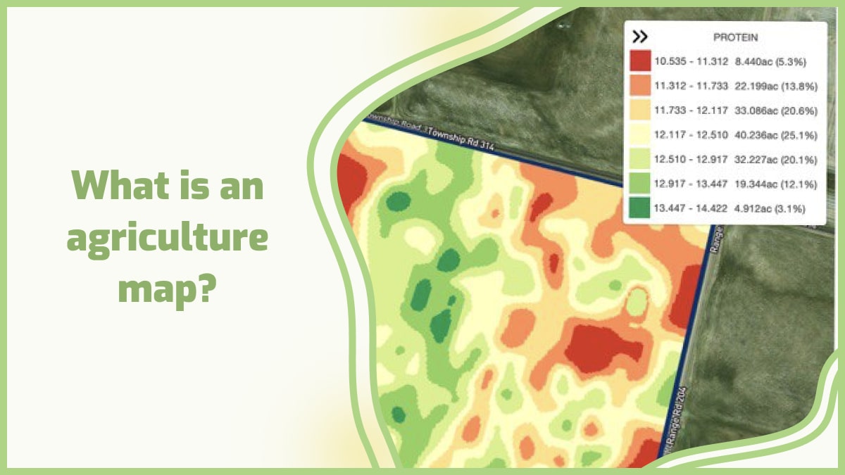
GeoPard capabilities and satellite imaging applications offer the users to visualize, normalize, analyze and derive insights directly from the agricultural plots in order to improve crop production. This data utilization can be done with the help of ready-to-use GeoPard algorithms or by creating your own algorithms to make them useful for agronomy.

These algorithms allow evaluation of crop growth, stress, etc. (see photo) or even create prescription maps: for example Nitrogen VR application maps, Crop Protection spraying application maps.


Frequently Asked Questions


1. How to get satellite imagery for farm?

To get it for your farm, research providers, sign up, and access their database or portal. Specify your farm’s location and desired parameters to retrieve relevant images for agricultural monitoring.

2. Why is satellite imagery helpful to understanding food webs?

It is helpful in understanding food webs due to its ability to provide a broad and comprehensive view of ecosystems. By capturing large-scale images of land and water bodies, it allows scientists to observe and analyze the spatial distribution of various habitats and resources.

This, in turn, aids in studying the interactions between different species, identifying key feeding relationships, and comprehending the flow of energy through food webs.

It helps unravel complex ecological dynamics, contributing to a deeper understanding of ecosystem functioning and conservation efforts.

3. How expensive is satellite imagery?

Its cost varies depending on several factors. These include the provider, resolution, frequency of acquisition, and extent of coverage needed. Prices can range from affordable options for low-resolution imagery to more expensive options for high-resolution and real-time monitoring.

Additionally, specialized services or customized data requests may incur additional costs. It is advisable to explore different providers and their pricing models to find a satellite imaging solution that aligns with your specific requirements and budget.

4. What is infrared satellite imagery? How to read it?

It captures the infrared radiation emitted by objects and surfaces on the Earth’s surface. It provides valuable insights into temperature variations and thermal patterns.

To read infrared satellite imaging, one must understand that warmer objects appear brighter in the image, while cooler objects appear darker. By analyzing these temperature variations, one can assess cloud formations, identify land and water temperature disparities, detect wildfires, and even monitor ocean currents.

Understanding the color scale and interpreting the brightness levels on the imagery helps in extracting meaningful information from infrared satellite images.

What is Agriculture drone mapping?

Agriculture drone mapping is the process of collecting data using a drone and then processing it to create an accurate map of an area. This can be done by flying the drone over a field, capturing images, and then stitching them together to create a high-resolution map that shows the boundaries of each field, as well as any vegetation or other features within them. Agriculture drone 3d mapping allows farmers to see exactly how much land they have available for crops and livestock, which helps them decide what crops to plant and how much space each crop should take up. A 3d agriculture map also allows farmers to see where there might be problems with weeds or pests so that they can deal with these issues before they become serious problems with their crops or livestock. It allows farmers to get a high-resolution view of their property. This can help them identify problem areas, like nutrient deficiencies or areas with poor drainage. It can also help them better understand how their fields are performing compared to other farms in their area. It is used by farmers to help them save time and money. Farmers can use the data collected from agriculture drone mapping to make better decisions about their crops and farming methods. Agriculturists can use agriculture drone mapping for many things, including:
  • Mapping out fields in preparation for planting and harvesting.
  • Monitoring crop growth during different seasons.
  • Comparing crop growth with previous years.
  • Minimizing risks of crop damage from bugs, pests, and diseases.
  • Plant and soil analysis.
  • Soil moisture mapping with drone.
  • Irrigation system analysis.
The drones used for agriculture are usually equipped with high-resolution cameras that can capture a detailed image of an area. The pictures captured using drone imaging can be used to determine crop health and yield, soil quality, and other factors that affect the success of crops. Agriculture drones are a relatively new tool in agriculture but they have been rapidly adopted by farmers due to their ability to collect large amounts of data in a short period. This information can be used to optimize decisions about growing crops, including where to plant next season’s seeds or how much fertilizer should be applied.

What is drone?

A drone is an unmanned aerial vehicle (UAV) that can fly autonomously or be remotely controlled by a human operator. They come in different sizes, shapes, and configurations, and can be equipped with various sensors, cameras, and other types of equipment depending on their intended use. They are commonly powered by electric motors and rechargeable batteries, and they can fly at different speeds and altitudes, depending on their design and purpose. Moreover, they work by using a combination of hardware and software components that allow them to take off, fly, and land safely. They typically have a flight controller that regulates their movements and behavior, as well as GPS sensors that provide location data for navigation. Sometimes, they also have cameras, obstacle avoidance sensors, and other types of sensors that allow them to capture images, detect obstacles, and avoid collisions.

What is drone mapping? How does drone surveying work?

Drone mapping is the use of a drone to create a 3D representation of an area. It is also the use of unmanned aerial vehicles (UAVs) to capture high-quality imagery and data. Drone imaging are often used for surveying and mapping construction sites, but they can also be used to capture images of other areas, such as farmland, forests, or even cities. The drone uses various sensors to create a more accurate image than a satellite or aerial survey would be able to create. The images are then analyzed and processed by software to create the 3D model. Drone imaging can be used for a variety of purposes:
  • Landscape architecture – Drone imaging is often used in landscape architecture to design public parks and gardens.
  • Urban planning – Drones can take aerial photographs and video footage of cities to help urban planners plan future developments.
  • Architecture – Architects can capture detailed 3D models of buildings before they go up using this technology.
  • The use of drones for mapping offers several advantages over traditional methods such as satellite images or ground surveys.
  • Drone imaging provide high-resolution data which can be used to create accurate maps. This technology is particularly useful when it comes to surveying difficult terrains such as water bodies or forested areas where it can be difficult to access on foot or by car.
 Mapping for Farm PlanningHere is how drone mapping works: a drone is mounted with sensors such as cameras and laser scanners that fly over an area capturing images or scanning it with lasers at various altitudes and angles. The collected data is then processed into 3D maps which can be viewed on a computer or smartphone screen.

The function of drones for agriculture

Here are some of the functions of drones for agriculture: 1. Mapping with drone for Farm Planning One major advantage that drone survey provide to farmers is accurate mapping information. This helps them plan their crops better and achieve higher yields through proper crop rotation. The main benefit of drones is that they allow farmers to save time by helping them plan out so many things from their harvests to their fertilization schedules. There are many uses for mapping with drones and some of the most common ones are:
  • Finding crop stressors like pests, weeds, and diseases.
  • Mapping fields for irrigation or fertilizer use.
  • Checking for drainage issues or erosion.
2. Multispectral Imagery Multispectral imagery is an important tool for farmers. One of the key uses of drones in agriculture is to provide farmers with information about the health of their crops. Multispectral images can be used to assess plant health by measuring chlorophyll content, which indicates how much photosynthesis is occurring. Multispectral imagery has been used in agriculture for several years but the process was slow, expensive, and difficult to use. Now drone survey make it easier and cheaper than ever before. 3. Soil Analysis Drones can be used for a wide range of applications in agriculture. One of the most important uses is soil analysis. Soil analysis is used to determine the nutrient levels in the soil, which can help farmers determine how much fertilizer they need to apply to their crops. If a crop is receiving too much or too little fertilizer, it will result in poor yield and quality. Using drone imaging for soil analysis allows farmers to get real-time feedback on their crop’s health and growth. This helps them make better decisions on when and how much fertilizer they need to use. 4. Crops Health Assessments (Scanning Crops with UAV Multispectral Technology) The use of drones for agriculture has many benefits. The most important is that it allows farmers to keep track of the state of health of their crops, allowing them to react quickly to any problems. This can be done through multispectral cameras attached to the drone. These cameras work by capturing images of the crops and analyzing them to determine if there are any deficiencies in the crop or not. The results can then be used by farmers to help them make decisions regarding their crops. For example, if there is too much nitrogen present in a certain area they may decide to reduce the amount of fertilizer they use in that area next year. This will help them produce larger yields and save money as well as protect the environment. 5. Livestock Tracking Livestock tracking is one of the most important functions of drones in agriculture. Drones can be used to track livestock and locate them if they are lost. Also, with the help of drone survey, you can easily track your livestock without having to physically check on them every now and then. Drones equipped with sensors will collect data about your animals such as their location, their health status, etc. This information can be used by farmers to determine if any animals need medical attention or if there is any threat to their security or safety. 6. Seed Planting Drones can be used to plant seeds at the optimal depth, distance apart, and speed for each seed type based on factors like soil type or weather conditions at planting time. This helps ensure every seed gets planted correctly so that every plant has the best chance of survival once it sprouts up through the ground. A drone can fly over acres of land within minutes, accurately spreading seed as well as monitoring its progress with sensors designed for this purpose. One of the major benefits of using a drone to plant seeds is that it allows farmers to save time and money. Farmers can also use drone survey to monitor their crops regularly throughout the growing season and make adjustments if necessary – such as adding fertilizer or water when necessary – before any damage occurs.

Innovative use of 3D drone mapping and imaging in modern agriculture

1. Terrain and Soil NDVI Mapping with drone  Agriculture Drone mapping allows you to measure salinity, soil type, and health in a matter of minutes. The elevations are visible in the accurate 3D maps that it can generate, which aid in soil research and seed and crop placement planning ahead of time. The data generated by the drone’s soil analysis report will show the status of the substrate and its requirements throughout the growing season, including individual water requirements and nitrogen management. Terrain and Soil drone Mapping 2. Prescription maps for fertilizers, herbicides, and pesticides with drone survey  Just one strategy is out of date, as it not only wastes resources, but it can also affect the health and vitality of crops. Too much water, for example, can kill an otherwise healthy crop by preventing its roots from absorbing oxygen, so even watering isn’t the best approach to growing flawless crops. The same is true for fertilizers; using the correct amount is critical for growth, as using too many causes burnt roots, which can destroy otherwise healthy plants. Drone mapping allows sprays to be splattered only where the problem exists, reducing waste of resources and the risk of harming healthy crops that do not require the same treatment. While humans would be unable to recognize the unique requirements of each plant in their crop, drone survey technology can do it in minutes. 3. Crop assessment At the touch of a button, scouting missions are launched; the drone departs the weatherproof charging station, collects data, and uploads it. The findings of the drone, as well as a study of its plant stress detection and the efficacy of any current treatments or amendments, can be used to adapt automated irrigation systems. With on-site scouting drones, constant health checks are possible. 4. Plant population count With the drone’s powerful AI technology, any variety of plants may be identified. This allows the entire production and total loss to be determined at the start and conclusion of each season, increasing precision and awareness of the growing season’s success. 5. Automatic classifications with drone imaging The drone imaging can tell what type of agricultural land it’s flying over, whether it’s arable, pastoral, or mixed. Drones may count the number of crops and livestock, as shown above, to verify that records are current and that any losses are noted. 6. Tracking crops Crop health isn’t predetermined because environmental factors might influence development. Temperature, humidity, nutritional and trace mineral content, insect and disease presence, water availability, and amounts of sun exposure are all elements to consider. All of these may be tracked using the drones’ different payloads, and many of these intangible variables can be handled by applying water or sprays directly to the needed regions. The healthier the crop’s surroundings, the stronger its immune system gets, and thus the healthier it becomes — with a far greater ability to ward off pests and diseases.

How to make a 3d map?

GeoPard can help in creating 3d maps for agricultural aims. It is a unique software that allows you to create your 3D models from any existing geographic data or scratch. GeoPard has all the functions necessary to create 3D maps from satellite images and other sources of aerial photography. The software allows you to classify this data according to different criteria, including color, texture, shape, and height. GeoPard also allows users to control the placement of objects on a map or in an image with great accuracy. This means that users can move objects on a map by simply moving them on their computer screen. The program also comes with integrated tools for editing images and photogrammetry processing features. These features let users do things like changing the scale or orientation of an image or combining multiple images into one large photo. Users can also create new textures by adding details like shadows or noise effects to existing photos. GeoPard can be used by farmers, agronomists, ecologists, geographers, engineers, and all others who need to create 3D maps for agricultural aims. Farmers can use GeoPard to plan crop rotation and fertilization, determine areas with low fertility or high salinity, study soil erosion and landslides, and locate wells and water channels to avoid their contamination by pesticides.

Frequently Asked Questions


1. How much area can a drone survey? The area that a drone can survey depends on various factors, including flight time, battery capacity, and regulatory restrictions. Generally, drones can cover several acres of land in a single flight, ranging from a few acres to hundreds of acres. The exact coverage area also depends on the altitude at which the drone is flown and the desired level of detail required for the survey. Advanced drones equipped with longer flight times and larger batteries can cover larger areas in a single flight, while smaller drones may require multiple flights to cover the same area. 2. What season do they fly the drones to analyze the crops? Drones can be flown to analyze crops throughout the growing season, but the timing may vary depending on the specific objectives. Generally, drones are flown during the vegetative stage, flowering stage, and maturation stage of the crops. Each stage provides different insights into crop health, growth patterns, and potential issues. For instance, early-season flights can help assess emergence and uniformity, while mid-season flights can detect nutrient deficiencies or pest infestations. Late-season flights can provide information on yield potential and harvest timing. Therefore, drone flights are conducted at various stages to capture a comprehensive understanding of the crop’s condition. 3. How to make money with a drone in the agriculture industry? There are several ways to make money with a drone in the agriculture industry. One option is to offer aerial imaging and mapping services, providing farmers with detailed aerial data for crop monitoring, field analysis, and yield estimation. Another avenue is to provide crop health assessment services, using specialized sensors to identify issues such as nutrient deficiencies, pest infestations, or irrigation problems. Additionally, offering drone-based spraying services for precision application of fertilizers or pesticides can be lucrative. Lastly, offering drone training and consultancy services to help farmers integrate drones into their operations can also be a profitable venture. 4. How much to charge for drone mapping? The pricing for drone mapping services varies depending on several factors. These include the size and complexity of the area to be mapped, the resolution and level of detail required, and the specific deliverables needed. It is common for drone mapping services to be priced per acre or per hour, with rates typically ranging from $100 to $500 per hour. However, it is best to consult with professional drone mapping service providers to obtain accurate and tailored pricing information for your specific project. 5. What is geomapping? Geomapping, also known as geographic mapping or spatial mapping, is the process of visualizing and representing geographic data on a map. It involves collecting, analyzing, and displaying various types of information such as locations, boundaries, terrain features, and infrastructure. Geomapping allows us to understand and explore relationships between different data points in a spatial context, enabling better decision-making and planning in areas like urban development, environmental management, and navigation. It is a powerful tool used in various fields including cartography, geography, urban planning, and resource management. 6. How to survey land with smartphone? Surveying land with a smartphone can be achieved using various apps and techniques. Firstly, download a reliable surveying app that utilizes the phone’s built-in GPS capabilities. Next, ensure the phone has a stable internet connection and enable location services. With the app open, follow the on-screen instructions to mark specific points, measure distances, and record relevant data. It is important to maintain accuracy by using additional tools like tripods or external GPS receivers if necessary. Always refer to professional surveyors for complex or legal surveying requirements.

Vegetation index: how are they used in precision agriculture?

Now, to have a whole conversation about precision agriculture, you need to speak about Vegetation Index, particularly when you’re discussing the role of remote sensing in this form of agriculture.

Vegetation is intimately involved with almost every facet of human existence, including the act of breathing, the provision of clothes and shelter, the production of food, etc. Any shift in the composition of the vegetation can influence the environment and the economy significantly.

Recent technological advances (geographic information systems (GIS), global positioning systems (GPS), remote sensing, and precision agriculture) have been the principal drivers of improved crop management. For instance, precision agriculture provides improved analysis and the discovery and control of both temporal and geographical variations in crop production within a field.

AgTech pioneers revolutionize precision agriculture via vegetation indices. It is of utmost significance in the achievement of the objective of this kind of agriculture, which is to maximize production while minimizing the number of resources used.

This modern use of vegetation indice in precision farming provides several advantages: physicochemical monitoring, real-time data, and farm activity planning. It is also possible to make efficient use of vegetation indexes mapping for future references to indicate the cyclical changes.

What are vegetation indices and their types?

Since 1974, the use of vegetation indexes, which assists in conducting periodic distant surveys of vegetation, has been widespread. Utilizing two or more spectral bands, this statistical model is a spectral transformation that may be used to detect vegetation in its more general meaning.

What are vegetation indices and their types?


Using this method, scientists and other curious individuals may efficiently watch photo-centric behaviors and spot differences in the canopy. If necessary, they can also draw reliable comparisons using this information. It involves evaluating a variety of variables, such as the development of the crop, its vigor, its biomass, and its chlorophyll content. Here is the list of vegetation indices:

  • NDVI (Normalized Difference Vegetation Index)
  • VARI (Visible Atmospherically Resistant Index)
  • ReCl (Red-Edge Chlorophyll Vegetation indexes)
  • EVI2 (Two-Band Enhanced vegetation index)
  • LAI (Leaf Area Vegetation Index)
  • WDRVI (Wide Dynamic Range Vegetation Index)
  • GNDVI (Green Normalized Difference Vegetation indexes)
  • GCI (Green Chlorophyll Vegetation Index)
  • RCI (Red Chlorophyll Vegetation indice)
  • NDWI (Normalized Difference Water Index)

What can vegetation index be used for?

When examining patterns in plant health, agricultural professionals such as farmers, agronomists, crop insurers, researchers, and others might benefit from using a vegetation index such as NDVI or VARI.

Users of the agricultural mapping and analysis tool can implement the index with the click of a button, producing a green or red patch on their aerial images, depending on the results of the index. The regions indicated by the color green have plants that are in good health. Colors such as orange, yellow, and red indicate a loss of energy and vitality.

For instance, a corn farmer may use the program to submit multispectral photographs of their cornfields at any point between the appearance of plants and the harvesting of the crop. The application would then apply the preferred vegetation index.

The colorful output may bring to their attention that a portion of the field has taken on an orange and red hue in certain places. It is an indication that the plants are becoming brown or yellow or that they are getting pockmarked. The plants in this region may be suffering from the effects of an extended period of drought, flooding, insufficient or excessive fertilization, or are infected with a disease.

As was the case before, ground-truthing was the most effective method for diagnosing a specific problem. Nevertheless, the vegetation indice provide the farmer with a hint that they should concentrate their efforts on a particular section of their land. They are free to investigate what caused the problem and consider possible solutions at this point.

Why are hyperspectral vegetation indices so important?

Integrating a reflectance spectrum into a single numerical value, known as the Vegetation Index, is a standard method for determining the qualities of vegetation. Hyperspectral Vegetation Indices, also known as Narrow-band Vegetation indexes, contain characteristics or wavelengths that hyperspectral equipment can only catch because of their shorter bandwidths.

Structure, biochemistry, and plant physiology or stress are the three primary categories that may be used to classify the vegetation attributes that can be assessed using HVIs.

  • The proportionate cover, Leaf Area Index (LAI), green leaf biomass, senesced biomass, and proportion of photosynthetically active radiation absorbed are all examples of structural features that may be measured. Most indices for structural analysis were designed for complete band setups and had narrow-band and hyperspectral counterparts.
  • Examples of biochemical features comprise water, pigments (such as chlorophyll, anthocyanins, and carotenoids), and other nitrogen-rich products (such as proteins). Plant structural components also fall under this category (lignin and cellulose).
  • A stress-induced shift in the status of xanthophylls, variations in chlorophyll content, changes in leaf wetness, and fluorescence are some understated alterations that may be measured using physiological and stress indices.

Why are hyperspectral vegetation indices so important?

Generally speaking, biochemical and physiological or stress indicators were developed with the help of laboratory or field equipment (spectral sampling of less than 10 nm). They are aimed at very tiny spectral characteristics. As a direct consequence of this, they are exclusively hyperspectral. Developed indices for water are the only exception to this rule.

Vegetation index and remote sensing technology

Earth-observing satellites supply remote sensing scientists with new data to feed their study and improve upon the analysis that has already been conducted as sensors progress.

Businesses that already have their index-based technology and those that are preparing to introduce a new one can substantially create a market for their agriculture-related products by embracing the latest innovations in spectral vegetation indexes applications. It is valid for companies that already have their index-based software and those planning to launch a new one.

The benefits vegetation indexes offer in remote sensing enhance the overall quality of the customer experience. Comparing satellite photography to different types of aerial data enables the following:

  • Reduced expenses of operation, processing, and interpretation of data collected by drones.
  • In comparison to aerial images, satellite imagery may cover a wider area.
  • Bringing down the costs of doing field inspections: extra UAV (unmanned aerial vehicle) observations are more expensive than standard satellite revisits.
  • Obtaining analyses of the data in a suitable format within a shorter amount of time.
  • Monitoring the fields regardless of how strong the winds are.

Using satellite imagery enables agricultural software companies to considerably increase the amount of aerial data they already have access to while also saving them time and money and allowing end-users to obtain more data in a shorter time.

Therefore, vegetation indice in remote sensing and crop monitoring help conduct a high-level, distant examination of the crop status. If there is a problem, farmers may choose to examine the areas that have been noticed rather than the whole field.

Reach out to GeoPard for a solution in your niche

The vast majority of the most critical vegetation indices, which number in the hundreds, have to be included in agricultural software in the form of a long list that can be accessed and used in a single location. GeoPard offers the essential analytics that can be integrated into the already available agriculture software and the planned software.

We will guide you on the optimal choice that will fulfill the requirements set out by you or your clients. No matter how you plan to utilize our product — API, white-label, or bespoke solutions — you can rest confident that the data you receive will be accurate and trustworthy since it was gathered using remote sensing and cutting-edge satellite technology.

GeoPard can provide accurate data-driven analytics on a worldwide scale. As a result, the company has won the satisfaction of many happy clients. Please contact us to discuss the specifics and potential of using remote sensing in your niche or industry.

Crop monitoring is a crucial tool that allows crop growers to detect problem areas and mitigate the risk of yield losses.

Easily monitor your crop development by relying on the latest satellite imagery. Add your field boundary to the system and access the complete satellite imagery archive on one screen:

  • Assessment of crop development conditions.
  • Detection of vegetation anomalies in near-real time.
  • Scout spots with different levels of crop development.
  • View through the clouds.

Translate the satellite imagery crop monitoring insights into fieldwork actions and benefit from making the data-driven decisions:

  • Detect the difference in crop vegetation between the latest images and scout the focused areas for tissue sampling.
  • Create Variable Rate Application maps for crop protection and in-season fertilization based on near-real-time field assessment and collect the execution report.
  • Mark the damaged field areas after a weather disaster or a disease or a pest attack and send reports to the insurance.
Learn more

Soil mapping as a tool for agricultural management

Soil mapping is a critical tool for understanding the ground beneath our feet. It provides essential information for land use planning, soil conservation, and agricultural management. It helps us understand the physical, chemical, and biological properties of soil and enables us to make informed decisions about land use and management.

Current food production techniques are far from sustainable. Intensive farming techniques and widespread chemical usage are draining our soil and poisoning our water. Furthermore, agriculture is responsible for a large portion of our water use; the World Bank estimates that agricultural use accounts for 70% of all freshwater usage globally.

Reports by the World Data Lab’s Water Scarcity Clock, indicate that around 2.3 billion people worldwide face water scarcity, and the trend is accelerating. To make matters worse, the global warming that is causing drought in many countries has increased the demand for water, particularly in Europe, which saw exceptional heat waves in the past year.

Sustainable development goals necessitate agriculture that is environmentally friendly while producing the best feasible yields. For encouraging sustainable agriculture with accurate inputs in amount, place, and time, detailed information on the soil profile and its geographical distribution is required. Accurate and up-to-date information on soil composition, in particular, enable better and more effective fertility management, boosting crop productivity and sustainability.

What is soil mapping?

Soil mapping is a process that involves the systematic observation and recording of soil types and their distribution within a particular area. It has several important applications. It helps farmers to make informed decisions about crop selection, fertilization, and irrigation.

It also assists land managers in developing strategies for soil conservation and restoration. Soil maps are also used by engineers and construction professionals to design buildings, roads, and other infrastructure projects that are compatible with local soil conditions.

Soils provide critical ecosystem services such as water filtering, flood control, plant growth medium, and habitat for soil biota. Agriculture covers around 38 percent of the Earth’s ice-free area, with croplands accounting for approximately 12 percent and pastures accounting for approximately 26 percent.

Soil information is thus essential for long-term soil management. The soil profile and its spatial distribution are two critical components for encouraging sustainable agriculture, which requires precise inputs in amount, space, and time.

The development of a numerical or statistical model of the link between environmental variables and soil qualities, which is then applied to a geographic data source to build a predictive map, is what digital soil maps (DSM) is all about.

Geocomputational technologies developed during the last couple of decades have enabled DSM. GeoPard technologies, for example, employ modern geographic information science, digital terrain modeling, remote sensing, and fuzzy logic to create extremely precise 3D soil survey maps.

However, one of the most significant challenges of soil mapping is the variability of soil types within a given area. Soil properties can vary greatly over short distances due to differences in topography, vegetation cover, and land use history. To overcome this challenge, soil scientists use statistical techniques to interpolate between sampling points and create a continuous map of soil types.

Soil mapping as a tool for agricultural management

GeoPard 3D soil maps can help agricultural businesses benefit from simplified and digitized soil management. They can learn about the soil characteristics beneath the ground’s surface over a vast area rather than only at certain locations.

This understanding enables farmers to implement the appropriate treatment methods. It can assist them in increasing fertility and consequently yields while minimizing water and fertilizer consumption.

How do the 3D soil maps help farmers and agricultural companies?

It has become common practice in so-called precision farming, which employs cutting-edge technology to acquire the most exact information about the condition of the soil, the weather, and the crops. Farmers benefit from this in the following ways:

  • Composition of the soil. It is critical to understand which soil elements exist in order to determine which crops or varieties are best suited to each land parcel.
  • CheckHumidity. It is critical to understand the humidity of each crop area. This allows for better irrigation management. This check is usually done using soil temperature maps.
  • Soil texture. Knowing the texture of the soil allows farmers to determine which fertilizers they can apply at any given time and location.
  • Ph and conductivity. It is critical to determine soil variables such as ph and conductivity in order to better select fertilizers and other nutrients.
  • Fertility. Knowing what fertility may be expected from a land plot is essential for selecting the best periods to cultivate crops.

Impact of soil mapping on farming productivity

To begin with, as previously mentioned, farmers learn about soil fertility and production by visualizing the elevation, slope nutrients availability, organic matter content, and soil PH of their land.

Not just farmers, but policymakers, researchers, and technicians would benefit directly from these maps, as policymakers may implement appropriate policies depending on soil quality for specific locations, and technicians can apply effective technologies.

The government can utilize the maps to make more efficient management decisions on fertilizer import, distribution, and recommendation, including blended fertilizers. It aids in crop selection and the development of extension programs aimed at enhancing soil health and increasing agricultural yield while also protecting soil from deterioration.

Impact of soil mapping on farming productivity

Agriculture and other industries are expanding their demand for soil information. For example, horticultural development officials may need to determine how much land under their control is suitable for fruit crops and where it is located, whether it is spread or clustered, and so on.

The business sector can use the obtained soil information to create dynamic and user-friendly mobile apps that deliver soil qualities, fertilizer-related information, and other information to formers as part of commercial Agri-advisory extension services.

These soil maps will not only help to enhance crop yields, but also the nutritional value of these crops, which will help to tackle public health issues such as nutritional deficiencies in the American population.

How to collect data using soil maps

Several strategies can be employed to obtain several levels of information about the soil. Traditionally, works were created with open earth pits, but today we have access to far more sophisticated instruments.

How to collect data using soil maps

These are the most important:

  • Electrical and electromagnetic sensors. One of the most common methods of mapping soil is to assess its electrical and electromagnetic properties. These values will help us understand its composition as well as a variety of other helpful information. The equipment that creates these maps used to be terrestrial, such as a tractor outfitted with a gadget capable of measuring these electrical values.
  • Optical sensors. In this situation, equipment is used that can detect color changes in soils, allowing for the interpretation of their features based on this information. Drones are increasingly being used in these treatments. They can take extremely accurate photographs of the earth from appropriate heights.
  • Mechanical sensors. A common way of determining the composition of a land plot is to use equipment that, when clamped to the soil, allows you to discover which types of materials make it up and in what densities.
  • Electrochemical sensors. These instruments can detect the presence of potassium, nitrates, and other elements, as well as their electrical properties.

The increase in farming productivity thanks to soil mapping

Climate, soil qualities, and the usage of production elements all influence agricultural productivity and yield quantity. Fertilizers, irrigation, seeds, insecticides, and farmers’ abilities all have an impact on farm output.

Precision agriculture is a new farming management strategy in which farmers collect and analyze data to optimize inputs and practices for the best results.

This information is then used to make decisions about which crops to sow and when and where to apply fertilizer, agrochemicals, or water. As a result, farmers can optimize their input use, making the most of their limited resources.

Our 3D soil maps could be useful to everyone who works in agriculture. However, the end consumers are the farmers themselves, who will save time and money while meeting increasingly stringent environmental regulations.

Agricultural businesses profit as well, as they can cut their time spent on soil care by more than 80%. Soil management is currently done primarily by hand, which takes a long time.

Using GeoPard technologies, a number of job tasks can be handled remotely, from a distance, or they can be automated. The user is not required to travel to the field in order to collect soil samples and send them to the laboratory. The advance planning steps are likewise avoided, as are the accompanying administrative expenditures.

This allows farmers to reduce the number of manual steps in the process and thus the time required to complete them. Our method is distinct in several ways: We are not attempting to improve current processes and procedures. Instead, we intend to apply novel ways to completely rethink an antiquated system.


Frequently Asked Questions


1. How will a contour map be useful for a farmer?

A contour map is a valuable tool for farmers as it visually represents the shape and elevation of the land. By using contour lines that connect points of equal elevation, farmers can identify the slope and drainage patterns of their fields.

This information helps in planning and implementing effective soil and water management practices, such as contour plowing, terracing, and installing drainage systems.

Contour maps also aid in preventing soil erosion, optimizing irrigation, and maximizing crop productivity by understanding the topographic features of the land.

2. Which of the following is not a common reason why soil maps are used?

They are commonly used for various purposes, including agricultural planning, land management, and environmental assessments. However, they are not typically used to determine the weather conditions in a specific area.

Instead, they provide valuable information about soil types, fertility levels, drainage characteristics, and nutrient distribution, enabling farmers to make informed decisions.

By understanding the spatial variability of soil properties, stakeholders can optimize land use and minimize environmental impacts.

3. What is soil productivity?

Soil productivity refers to the capacity of soil to support plant growth and provide essential nutrients for healthy crops. It is a measure of the soil’s ability to sustain high yields and maintain the desired level of agricultural production over time. 

4. Who uses soil maps?

They are used by a variety of individuals and organizations involved in agriculture, land management, and environmental planning. Farmers and agronomists use them to make informed decisions about crop selection, fertilization, and irrigation.

Land planners and developers utilize them to determine the suitability of land for various purposes, such as building infrastructure or conserving natural areas. Environmental scientists and researchers rely on them to study soil characteristics and their impact on ecosystems.

Additionally, government agencies and policymakers utilize maps for land-use planning and conservation efforts.

5. Which slope element is suitable for farming?

Gentle slopes are generally considered suitable for farming due to their favorable characteristics. These slopes provide adequate drainage, minimize erosion risks, and allow for effective water infiltration.

They also facilitate machinery operations and reduce the potential for soil compaction. Gentle slopes offer a balance between sufficient water retention and proper water drainage, making them conducive for various agricultural practices and crop growth.

6. What is soil management?

Soil management refers to the practices and techniques used to maintain and improve the quality and productivity of soil for agricultural purposes.

It involves strategies such as soil testing, nutrient management, erosion control, irrigation management, and crop rotation. Soil management aims to optimize soil health, fertility, structure, and moisture content to support sustainable and productive agriculture.

By implementing proper soil management practices, farmers can enhance crop growth, minimize soil degradation, and protect the long-term productivity of their land.

How to do organic farming from a data point of view

According to ‘The World of Organic Agriculture 2020,’ 1.5 percent of farmland was under organic cultivation in 2018, up from 0.3 percent in 1999. This depicts how many farmers are embracing organic farming. Managing an organic farm may not be so easy but in the end, it’s worth it.

What is Organic Farming?

Organic farming is an agricultural system that aims to produce food in a sustainable and environmentally friendly manner. Unlike conventional farming, which relies heavily on synthetic fertilizers, pesticides, and genetically modified crops, it uses natural and organic inputs to support soil fertility and plant growth.

The first step in organic farm management is to understand your soil. That’s because your soil is the foundation of your food. It’s also a good idea to take samples of all your organic farms every year and send them off for analysis. If you have not done this before, you may be surprised by what you will find.

It is a system of agriculture that promotes and enhances biodiversity, biological cycles, and soil biological activity. It emphasizes the use of management practices that restore, maintain, and enhance ecological harmony. Its main aim is to produce food in a way that respects both humans and the environment.

It focuses on maximizing the health of the soil, plants, and animals. The goal is to make sure that the entire ecosystem remains healthy. It also aims to minimize pollution by using natural methods instead of artificial ones.

There are many benefits associated with organic farming. Some of these include better soil quality due to increased microbial activity; reduction in soil erosion; increased plant health; increased resistance against pests; reduced use of pesticides; lower levels of water pollution; improved animal welfare; reduced greenhouse gas emissions.

Organic agriculture uses management practices that help sustain the health of soils, ecosystems, and plants growing in the field. Organic farmers are concerned about maintaining soil structure, fertility, and health. They plant cover crops and rotate crops frequently to keep nutrients balanced in the soil.

Organic farmers do not use synthetic pesticides or herbicides. Instead, they use crop rotation, mulching, composting, or other cultural practices to control weeds, insects, fungi, or other pests. Organic farmers may also use mechanical methods such as hand weeding or pest control devices like traps to reduce the need for pesticides or herbicides on their farms.

Its methods include:

  • Rotating crops so that fields do not grow the same crop year after year.
  • Using organic fertilizers such as composted manure instead of chemical fertilizers made from petroleum products.
  • Avoiding genetically modified organisms (GMOs).

Organic farmers use sustainable methods that conserve soil and water resources, reduce pollution from runoff and increase biodiversity in agricultural ecosystems. They don’t use antibiotics to prevent disease in livestock because these drugs can be harmful to humans who consume meat from treated animals.

Organic producers are committed to the following principles:

  • Producing food in a way that respects the health of our ecosystems, conserves biodiversity, and avoids synthetic chemicals.
  • Protecting our natural resources by promoting soil fertility and crop rotations.
  • Providing an environment where animals can thrive on their own and are treated humanely.
  • Ensuring that food is produced in a socially responsible manner by supporting local economies.

Why is organic farming?

One of the main reasons why it is important is its positive impact on the environment. These practices promote biodiversity, reduce pollution, and conserve water and soil resources. For example, organic farmers use natural methods such as crop rotation, composting, and cover cropping to enrich the soil, reduce erosion, and control pests and diseases.

1. How do organic farming practices relate to soil health?

These practices have a positive impact on soil health because they do not use chemicals that can harm the soil. Organic farmers also put more emphasis on crop rotation and planting cover crops, which help prevent weeds from taking over the field. These methods are better for the environment and are better for the health of the soil as well.

Organic fertilizers such as manure and compost are also used by organic farmers. These fertilizers contain nutrients that help plants grow, but they also add organic matter to your soil so it can retain water and nutrients more effectively. In addition, organic fertilizers help create a healthy balance of bacteria, fungi, and other organisms in your soil so that plants have access to all the nutrients they need to thrive.

How do organic farming practices relate to soil health

Organic farms improve soil fertility by recycling crop residue back into the soil instead of burning it as trash or sending it to landfills. Plus, organic farms have less soil erosion than conventional farms because they don’t use chemicals that kill weeds and decrease soil stability. Instead of killing weeds with herbicides, organic farmers rely on crop rotation and tillage to control weeds.

Why is organic farming better for the environment?

It has many advantages but some of the specific benefits for the environment are:

  • Organic farmers don’t use synthetic pesticides, herbicides, or fungicides. These chemicals are toxic and can pollute the air, water, and soil.
  • Organic farms reduce soil erosion by using cover crops to protect the soil from rain and wind erosion.
  • Organic farms increase biodiversity by using cover crops to attract beneficial insects that help control pests. This reduces the need for pesticides and herbicides.
  • Organic farms provide more wildlife habitat. Organic farms are generally more diverse than conventional farms and provide a more complex ecosystem that provides more food for wildlife and helps to maintain biodiversity.
  • Organic crops also require less water than conventional crops because they are not watered with fossil fuels like petroleum or coal which require large amounts of energy to produce.

What is one advantage of organic farming over conventional farming?

One of its advantages over conventional farming is that it produces healthier food. Organic food is grown without the use of pesticides, herbicides, hormones, or antibiotics. This helps to ensure that organic food is free from chemicals that can be harmful to humans. Organic foods are also better for the environment than conventional foods because they do not pollute the soil or water with toxic waste.

What is an organic field?

Organic fields are fields in which crops are grown without the use of chemical pesticides or synthetic fertilizers. An organic field is prepared in a way that will allow the growth of crops for human consumption. Organic fields are not only used to grow crops but they can also be used to raise animals for food.

The main difference between an organic field and a traditional field is that in an organic field, no chemicals or pesticides are used. This means that the soil is left untreated and natural, which gives it a different appearance than other farming methods.

In addition to growing crops and raising animals, an organic field can also be used as a place for research. Some scientists use these fields because they offer them a chance to study how plants grow naturally without any interference from humans or environmental factors.

What are the standards of organic agriculture?

The legal framework, principles, and standards for organic production, control, and marketing in the European Union were presented by the Council Regulation (EC) No 834/2007 of June 28, 2007, as well as two 2018 Commission Regulations. Except for a few special circumstances of local manufacture, these texts are intended to supersede all national standards.

Since July 2010, all products from organic agriculture packaged in the EU must include the logo of the European organic label, also known as the euro sheet, as well as the name of the certifying authority. The national label logos are optional and are frequently omitted.

How do you plan organic farming?

Planning is essential in this farming method. The key is to plan and be ready for what is going on with the crops, weather, and other factors. Here are a few tips to help you plan your organic farm:

1. Research your crops

If you want to know what stage your crops are at, then research them. There are plenty of resources online that can give you an idea of how long it takes for the plants to grow, how much water they need, and how much food they will produce. Once you have this information, you can plan when to sow seeds and when to harvest them so that they reach maturity at the right time.

How do you plan organic farming?

2. Get expert advice

If you don’t know much about organic agriculture then get some advice from experts in the industry. They will be able to guide you through everything from seed selection to crop rotation and pest control methods. This will ensure that your crops are grown safely without harming the environment or causing problems for local wildlife such as birds, bees, or butterflies.

3. Keep records of everything

Keep records of everything that happens on your farm including soil testing results, crop rotation plans, and anything else that has an impact on how well your crops grow. This will help you identify any problems with pests or diseases.

What are the challenges of organic farming?

Here are some of the major challenges:

1. Time is vital

The issue of timing is one of the most difficult aspects of this farming method. This isn’t true in every case, but organic fruit and meats, in general, need efficient supply chains to get to market faster. The primary distinction between organic and conventional farming practices is the use of fewer chemicals in the food production process.

However, despite their obvious health benefits, organic products are more prone to deterioration for a variety of reasons. Organic products must be consumed sooner to ensure food safety and appeal due to temperature variations during shipping and generally shorter shelf life.

2. Pests also need your organic products

Pest infestations, which are as old as farming itself, are another major difficulty for organic farmers. Crop devastation is caused by pests such as rats and insects that are not controlled. As a result, for a long time, people have used chemicals known as pesticides to effectively deal with pests.

Many of those chemicals, however, are not permitted because they are not of natural origin and are detrimental to the environment.

As a result, organic farmers must find new and more effective ways to combat pests. Even though pesticides are prohibited in organic agriculture, organic farmers can still use insecticides made from natural substances. Diversified crops, traps, mating disruption, and the use of birds and other insects are all options for dealing with pests.

3. It is harder to market organic products

As previously said, it is critical in organic agriculture that products reach the market swiftly to remain fresh and healthy. Organic fruit, on the other hand, is at a disadvantage in a culture where long commutes and internet orders are the norm.

As a result, organic farmers must find local distribution outlets for their products, which may not always be practical. Farmers should instead invest in high-quality temperature control vehicles to allow for extended transporting times. Organic products can then reach far-flung regions with significant demand.

4. A limited supply of organic food

The production yields of organically grown food are lower than those of conventionally grown food, which is the last hurdle of organic farming. Organic agriculture requires an additional area to meet historical output levels, in addition to poorer production owing to the lack of artificial fertilizers, herbicides, and insecticides.

Farmers should do their studies and plan for their crops to deal with it. They must ensure that a specific variety or type of crop is appropriate for the region, as well as that the crops they produce are always in season.

How much land is needed for organic agriculture?

You can use between 1.5 to 200 or more acres of land for organic agriculture. The average size of an organic farm is 285 acres – significantly less than the average for all farms, which is 444 acres. However, organic farms make up for their small size with profitability.

GeoPard is a data analytics service that helps farmers to identify the yield-limiting factors in their fields and use this knowledge, along with data analytics, to get better ROI, better soil, and sustainability.

When you have information about the yield-limiting factors in your fields at hand, you can start making decisions about what to do next. The solution relies on data from sensors that are currently widely available and inexpensive. A small number of sensors can provide valuable insight into your fields.

Data from sensors is processed by GeoPard algorithms before presenting it in an easy-to-use interface or API call format. This allows you to easily integrate it with existing software solutions for crop management and farm operations management systems (FMS).

How can we control weed with the variable-rate application?

This article aims to provide an overview of the usage of herbicides (herbicide application) in variable rate application (VRA) to control weeds more precisely or precision weed control. As, precision agriculture allows the mapping of soil physicochemical properties, localized fertilizer application, pest monitoring, harvesting, and post-harvest operations.

Further, it also allow weed mapping and control of weeds (precision weed control) with site-specific sprays via weed mapping app or equipment or real-time systems, rationalizing pesticide use and minimizing environmental damage.

What is variable rate application technology?

Variable Rate Application (VRA) is a term used in precision agriculture to describe the process of applying the material so that the rate of application is adjusted depending on the exact location of the area to which the substance is being implemented or the characteristics of the region.

This method is distinct from uniform application and has the potential to both save money (by utilizing less product) and reduce the negative effect on the environment.
Variable Rate Application of Herbicides for Weed Management

What is a control variable?

A control variable, also known as a controlled variable or constant variable, is an element that is not changed throughout an experiment, because its unchanging state allows the relationship between other variables being tested to be more accurately identified and understood.

Control variables are crucial in scientific experiments to ensure that the results are valid and that a fair comparison can be made between experimental groups and control groups.

They are the factors in the experiment that are kept the same for all groups to ensure that it’s the independent variable (the variable you change) that is causing any observed change in the dependent variable (the variable you measure).

For example, if you were conducting an experiment to see how different fertilizers affect plant growth, the type of fertilizer would be your independent variable. The plant growth would be the dependent variable.

Control variables could include the type of plant used, the amount of sunlight the plants receive, the amount of water each plant gets, etc. By controlling these variables, you can be more confident that any differences in plant growth are due to the different fertilizers, and not to other factors.

Variable rate technology equipment for precision weed control

The control systems available on the market today may be adapted to various precise applications, and there are many different kinds of control systems to choose from. To make this debate more manageable, we shall group them into one of three groups.

1. Flow-based control system

The flow-based control of a tank combination is the most straightforward method out of the three described in this article. These systems use an electronic controller in conjunction with a flow meter, a ground speed sensor, and a controlled valve or servo valve to apply the required rate of the tank mix.

A microprocessor located in the console gathers data on the sprayer width and the intended number of gallons per acre to determine the flow rate optimal for the level of ground speed currently being experienced. The servo valve is adjusted, either open or closed until the flowmeter’s reading corresponds to the estimated flow rate.

An application for a variable rate may be created if a communication connection can be made between this controller and a “map system.”

2. Direct injection

Direct injection of the chemical into a flowing body of water is an additional method that may be used to apply and manage chemicals. In these systems, the chemical injection rate is operated by a controller in conjunction with a chemical pump.

These systems do not control the flow rate of a tank mix. In most cases, the flow rate of the carrier remains unchanged. Still, the injection rate is changed to account for fluctuations in ground speed or changes in the requested rate. Again, for the system to be utilized for variable rate application, the controller must be constructed to take an external command or be updated to accept such a command.

Chemical injection eradicates any residual tank mix and decreases the chance of being exposed to toxins. The steady flow of carriers may be altered in this system’s operation to run the boom nozzles to create droplets with a desired size and distribution is an additional benefit of this system.

3. Direct chemical injection with carrier control

When the chemical injection is combined with carrier control, the control system must adjust both the chemical injection rate and the rate at which the water carrier is delivered to accommodate changes in either the speed or the application rate.

One control loop is responsible for managing the injection pump, while another controller is in charge of operating a servo valve to produce a proportional flow of water. An excellent example of this sort of system would make a mixture with a consistent concentration, precisely as if it were being drawn from a tank that was already mixed.

The system has the potential to possess many of the benefits offered by the two preceding systems. Because the chemical is injected directly into the tank, there is no risk of contamination from the residual mixture. The operator does not come into contact with any hazardous substances while the tank is being mixed.

The transition from one rate to another happens as rapidly as the chemical and carrier control can making the necessary adjustment is often an extremely speedy process.

Weed density map  and variable rate application (VRA) of herbicide

Suppose you perform a fair bit of spraying and want to avoid the dangers of tank mixing. In that situation, these frameworks will give you much control over your spraying activities and offer the potential to implement variable rates of herbicides from a pre-planned map.

Sensor-Based VRA of herbicides

The application might be based on maps or sensors, which can happen at an inconsistent rate. It is unnecessary to produce an earlier topographic map since sensor-based VRA can gather data on the presence of weeds and analyze the information in fractions of a second before applying herbicides.

Without mapping or previous data collecting, sensor-based systems can adjust the application rate. Sensors detect the necessary attributes in real-time, even when they are moving. The measurements that are taken by the system are analyzed very instantly and then provided to the controller. The controller will then carry out the application at a varying pace.

Sensors do not inherently need the deployment of a positioning system, the construction of a map, or substantial data analysis before creating the VRA. Compared with the approach that relies on maps, this system is quicker and more efficient. Still, it also provides a higher level of precision.

Variable rate application (VRA) of herbicides in preemergence

The precision weed control that has not yet germinated is the purpose of an herbicide application in preemergence. The herbicide treatment is made immediately in the soil. As soon as the seeds or propagules sprout, they may absorb the herbicide.

However, for this to happen, the herbicide used has to be bioavailable in the soil solution. Due to the interactions between herbicides and soil, which are controlled by various physical, chemical, and biochemical mechanisms, the application of herbicides in preemergence leads to a variety of possible destinations.

VRA of herbicides in postemergence

The precision weed control of weeds that have already made their appearance in the field targets a treatment known as postemergence. As a result, the application will focus on the section of the plant species found above ground.

For the VRA to be used in the postemergence phase of treatment, the system must have access to information on the weed population in the zone. Both the map-based and the sensor-based techniques can collect this information. Therefore, any approach may be used for dealing with postemergence VRA.

The whole process of data gathering and map production for postemergence herbicide application must be completed as rapidly as possible. The weed dynamics may shift, and the infestation levels can rise in days, rendering the suggestion map irrelevant.

There is no need to do an earlier mapping of the field before administering postemergence herbicides using an approach based on real-time sensor data. The process of spraying relies on sensors that are mounted to the sprayer. These sensors are responsible for locating weeds and determining the appropriate herbicide dosage.

When selecting the best solution provider of precision weed control and variable-rate application, GeoPard seems to be the ideal choice. Some of its significant offered opportunities are:

  • The generation of VRA maps is fit for use with the majority of agricultural equipment.
  • No export restrictions will be placed on management zones or VRA maps.
  • Streamline incorporation of its maps into your already established procedures to simplify precision weed control.

With the help of VRA maps, deliver the proper agricultural inputs that will work for you in the suitable data zones and practices, such as fertilization, crop protection, planting, water management, herbicide application, and other similar practices. Establish unit prices and discover unit and total expenses.

Multi-layer Farming and its Benefits

Multilayer farming is the process of growing multiple crops in a single field. This is done by planting a crop on top of an already existing crop. The first crop is then harvested, and the land is used to plant another crop.

The purpose of this is to save space on land and improve efficiency. It is an ancient method of farming that is used to increase crop yield and avoid competition between plants.

Multi-layer farming is a type of polyculture that involves growing multiple crops in a single area. It generally involves growing plants at different heights, so that one crop grows on the ground and another grows above it.

It is a kind of agricultural method that is used to optimize the use of land and improve the quality of the soil. The main idea of this kind of farming is to plant different types of crops in one field, and then use the remains from each crop as fertilizers for another.

For example, you might grow lettuce in your vegetable garden and also plant tomatoes on a trellis above. Multilayer farming models work best when there is a short growing season like during the fall or winter months when temperatures are cooler and the sunlight is limited.

Some of the benefits of multi-layer farming include:

  • It allows you to grow more food while taking up less space. This is especially helpful when you are working with limited space, such as a balcony or backyard garden.
  • It also helps to avoid soil depletion by alternating different crops each year; this way, you don’t need to add amendments (such as compost or manure) every time you plant something new.
  • The practice of multi-layer farming provides greater variety for your family’s diet and your pests and diseases because it offers more choices for pests and diseases to attack — so there’s less chance that they will all go after the same thing at once.
  • You can also use multi-layer farming to control crop yields over time; for example, if you have too many tomatoes on your hands in July but not enough carrots in September, you can plant a second layer of tomatoes in late August/early September so that they will ripen very early.
  • You will enjoy increased crop yields. Many crops can be grown together in one field, increasing overall yields by up to 30 percent compared with conventional methods. This is because each plant has its root system and nutrients from the soil are shared among the group.
  • Reduced losses from pests and diseases. Multi-layer planting helps protect plants from pests because there are fewer available for the attack on each plant. For example, onions planted above carrots protect the carrots from carrot fly pest attacks, while radishes growing below tomatoes protect them from fungal diseases such as Verticillium wilt.
  • Since multilayer farming provides an opportunity for organic farmers to increase their yields, it helps them in making more money from their land.
  • Diversification of risks by planting different species side by side to prevent total crop failure if one fails due to disease or pests.

What is multi-layer farming?

Multi-layer farming is a method of crop production in which one or more crops are grown simultaneously on the same piece of land. The purpose of multi-layer farming is to increase profitability and productivity.

It allows for multiple harvests from the same plot of land during one growing season, which can improve the overall efficiency of agriculture. It also allows farmers to diversify their crop production to reduce risk factors associated with crop failure and price fluctuations.

It may involve planting different types of plants at different times in the same field during one growing season. For example, a farmer may plant vegetables on top of a bed that was previously planted with potatoes, then harvest them both at once for sale as mixed vegetables or frozen fries.

This method can be used in conjunction with companion planting or intercropping (also known as mixed cropping) to further increase productivity and reduce pest damage while also improving soil fertility.

It is an efficient and sustainable way to grow food that can help you cut down on waste and use resources more efficiently. It allows you to grow more food in less space and use fewer chemicals. It also helps with pest control, by alternating plantings so that pests do not have time to build up their populations.

Multi-layer farming is also called intercropping and polyculture because it involves multiple types of crops being grown together. While there are no hard and fast rules about what makes one type of crop a different layer than another, the idea behind multi-layer farming is simple: different plants have different needs, so by combining them in one space you can make each type of plant thrive.

It’s a technique that can be used to increase the productivity of small plots of land, by growing different crops in layers that can be harvested at different times. It can be used with any type of crop, but it’s most common for subsistence farmers who have limited resources and land available for planting. The practice has been around for centuries, but it’s gaining popularity as more people are realizing its potential benefits.

In multilayer farming, the first layer should be made up of plants that can tolerate low levels of light and will grow quickly in this environment. These plants can be used as food for the fish or they can be harvested before the next layer is put down.

The second layer should contain plants that need more light but fewer nutrients than the first layer. These plants will grow slowly but will not compete with the lower layer for nutrients because they are not competing for light at all.

The third layer should contain plants that require high levels of both light and nutrients and need to be harvested early so that they don’t use up all the resources needed by other layers further down the system.

Basic principles of multilayer farming

The basic principles of multilayer farming are:

  1. Increase the efficiency of the system.
  2. Use of a lot of input.
  3. Crop diversification options are based on ecological, economic, and scientific grounds.
  4. Increasing the efficiency of resource utilization.

On a long-term basis, agriculture resources and the environment must be sustainable. This system consists primarily of an overstory of trees or shrubs with a forage or economy crop understory. The gap between trees can be large enough to allow enough light to reach ground cover.

What is the benefit of multi-layer farming?

Multi-layer farming is an ancient practice that is now making a comeback. It’s also called “intercropping” or “polyculture“. It means growing more than one crop on the same piece of land at the same time, sometimes with different crops on top (the canopy) and sometimes with different crops in the soil below.

The benefits of multi-layer farming are many. They include:

1. Increased yield

Growing several crops together increases yields because their roots fertilize each other and because more plants are working together to produce more food.

2. Faster growth

Many crops grow faster when they’re grown together, especially if they’re planted close to each other and watered regularly.

3. Fewer weeds

Because weeds compete with crops for water, nutrients, and sunlight, they tend to crowd out slower-growing plants when they are allowed to grow unchecked by human interference (weeding). But if you plant fast-growing plants among slower ones, you will have fewer weeds overall.

4. Fewer pests

Pests prefer certain kinds of plants over others — so planting a mix of different species reduces pest problems overall by making it harder for them to find their favorite foods.

5. Increased biodiversity

It helps increase biodiversity because different types of plants are grown together in one space. This provides an ideal habitat for birds, bees, and other insects that contribute to pollination and other ecological processes necessary for maintaining healthy ecosystems.

The cash flow is maintained by multilayer farming. Farmers can maintain financial viability throughout the year by growing different crops.

  • It also employs a large number of people throughout the year.
  • It also helps to mitigate the effects of severe rain, landslides, and soil erosion.

Multiple crops necessitate a variety of nutrients, thus the soil is replenished with a variety of nutrients, enhancing its fertility. This technique enhances the soil’s water retention capacity. The likelihood of crop failure is minimized as a result of multiple cropping.

Planting different types of crops together in one field allows us to use them as natural pesticides by using their roots as barriers to keep pests from going inside our fields thus protecting your crops from being eaten away by them during their growing stages.

Planting different types of crops together in one field allows us to use them as natural pesticides by using their roots as barriers to keep pests from going inside our fields thus protecting your crops from being eaten away by them during their growing stages.

Steps to perform multi-layer farming

Here are the steps that are taken to perform multi-layer farming:

1. Crop selection

Different crops are chosen to grow. Crops must have varying heights and maturation periods.

2. Field selection and preparation

Geometrical shapes (Square and Rectangle) are thought to be suitable terrain for multi-tier farming. Tillage, FYM addition, and composting are all examples of operations that should be carried out. With the help of tillage, a healthy seedbed is formed.

3. Seed selection and treatment

A high-quality seed of various crops is chosen. A pure, healthy, vigorous seed with a high yield potential is ideal. Seeds are disinfected to protect them from seed-borne or soil-borne illnesses.

4. Irrigation

Irrigation is when water is applied to crops artificially. Irrigation is one of the most crucial factors of plant growth. It is critical to meet the requirements for transpiration and photosynthetic activity. Water is used to dissolve the nutrients that are present in the soil.

Irrigation is especially important in multi-layer farming. Neither too much nor too little water is provided. The use of a moderate amount of water is often preferred. For irrigation, the ring basin approach works well.

5. Addition of manures and fertilizers

Manures and fertilizers are used to ensure that crops grow and develop properly. Different crops necessitate various levels of nutrients. As a result, the basal approach is most commonly used. For crop growth, FYM, compost, and NPK are critical.

6. Weeding

Weeding is done in the field to eliminate undesired vegetation. In multi-layer farming, hand weeding, hoeing, and sickling are effective weeding methods. Weedicides can be used instead to eliminate weeds. To kill pests and insects, insecticides and pesticides are utilized.

7. Harvesting and post-harvesting

Beneficial parts of crops are removed and stored in a secure location.

8. Packaging and marketing

For-profit, the materials are packed and sold on the market.

Steps to perform multi-layer farming

Below are examples of crops based on multilayer farming:

  • Maize, green gram, and groundnut.
  • Pointed gourd, elephant foot, yams, cucumber, and cauliflower.
  • Spinach, radish, and onion.
  • Okra, radish, cluster bean, and beetroot.
  • Pigeon pea, rice(upland), and black gram.
  • Sugarcane, mustard, and potato.
  • Pigeon pea, groundnut, and sesame.
  • Coconut, jackfruit, coffee papaya, and pineapple.
  • Mango, guava, and cowpea.
  • Coconut, banana, and coffee.
  • Coconut, coffee, and black pepper.

It is a sustainable method of producing crops. It involves having crops on various levels of soil, which allows them to be harvested at different times during the year. Multilayer farming strives for the most intensive and effective use of available resources. It emphasizes maximum crop productivity with minimum nutrient handling and infrastructural costs.

Multilayer farming is beneficial to the farmers and it has multiple benefits. From providing nutrients to crops, less water needs to be used, growing plants faster and protecting them from pests are some of its benefits. This farming system can be done on both small and large scales.

In this article, we have gone through the main aspects of multi-layer farming and its benefits. We hope this article will help you in making your choice of adopting multi-layer farming as a method of farming. Hopefully, you too will look into this technique to expand your farm or just as a way to be more sustainable.


Frequently Asked Questions


1. Difference between intercropping and mixed cropping?

Intercropping and mixed cropping are both agricultural practices that involve growing multiple crops together. The main difference lies in the arrangement and purpose of planting. Intercropping involves growing different crops simultaneously in a specific pattern or arrangement, typically to maximize resource utilization and complement each other’s growth.

Mixed cropping, on the other hand, refers to the practice of growing different crops together in the same field without a specific pattern, often for the purpose of reducing risk by spreading it across multiple crops or for maximizing overall yield.

While intercropping focuses on strategic combinations, mixed cropping is a more generalized coexistence of different crops in a single field.

2. Difference between cropping system and farming system?

Cropping system and farming system are related terms that refer to different aspects of agricultural practices. A cropping system refers specifically to the arrangement and sequence of crops grown on a piece of land, including factors like crop rotation, crop combination, and planting schedules. It focuses on the management of crops within a specific area.

On the other hand, a farming system encompasses a broader perspective, considering all aspects of agricultural activities, including crop production, livestock management, soil and water management, and other farm components.

It involves the integration of various elements to create a sustainable and efficient farm operation. While cropping system relates to the specific arrangement of crops, farming system considers the holistic approach to agricultural practices.

3. What is a layer in agriculture?

In agriculture, a layer refers to a type of poultry bird that is specifically raised for egg production. Layers are hens that have been selected and bred for their ability to lay eggs consistently. They are typically kept in specialized housing systems, such as battery cages or free-range environments, to facilitate egg collection and care.

Layers play a crucial role in meeting the demand for eggs and are raised for commercial egg production in the agricultural industry.

4. What is the difference between multiple cropping and modern farming method?

Multiple cropping involves growing multiple crops on the same land within a year to maximize productivity.

Modern farming methods encompass innovative techniques and technologies to enhance agricultural practices, such as advanced machinery, precision farming, and sustainable approaches.

While multiple cropping focuses on crop diversity, modern farming methods emphasize efficiency, productivity, and sustainability through technological advancements.

5. How farming works?

Farming is a complex process that involves several key elements. It begins with land preparation, including clearing, tilling, and soil preparation. Next, farmers select and sow suitable seeds or plant seedlings, ensuring proper spacing and depth.

Throughout the growing season, farmers provide essential care such as watering, fertilizing, and protecting crops from pests and diseases. Finally, at the appropriate time, crops are harvested, often using specialized machinery.

Farming requires knowledge of crops, soil health, weather patterns, and effective management practices to ensure successful cultivation and maximize yields.

Crop yield prediction with remote sensing data in Precision Agriculture

For crop yield prediction, we need to understand how much sunlight plants receive and how much water they need. Plant growth depends on these two factors, but many other factors affect plant growth such as temperature, humidity, and soil type.

The quantity and quality of crops produced in the world is a major factor affecting food security. This is especially important in developing countries where agriculture is still an important part of the economy.

Remote sensing data can be used to estimate quantities of light received by plants and thus predict crop yield. Remote sensing data is a powerful tool for estimating crop yield. It provides information on the growing crops and their environment, allowing you to estimate crop production.

Remote sensing data is a form of data analytics in agriculture that can be used to predict yield before the harvest. This article explores everything you need to know about remote sensing data.

What is crop yield data in agriculture?

Crop yield data is information on the amount of crop produced by a farmer or farmer group. It includes the amount of crop harvested per hectare of land. This can be measured in tonnes, bushels, or any other unit of measurement depending on the crop.

Farm Yield data is important when it comes to agriculture because it can help farmers determine how much they should plant next season. In addition, yield data allows them to determine if there’s a problem with their crops that needs to be addressed.

Yield data can also be used to monitor progress toward global goals set by governments, non-governmental organizations, and other stakeholders.

In addition, yield data is used to identify strengths and weaknesses in farming practices and make recommendations based on this information. Yield data is useful in making informed decisions about many aspects of farming, such as:

Data analytics in precision agriculture

Seed selection: Choosing varieties and hybrids based on yield data can help ensure that fields are planted with the most profitable seeds available.

Pest management: By monitoring plant growth, yield data can help farmers determine when to introduce pest control measures. This can reduce the use of pesticides and increase profits.

Irrigation scheduling: Using information from yield monitors allows farmers to fine-tune irrigation scheduling, which helps conserve water and money while maintaining high yields.

What is remote sensing data?

Remote sensing is the science of acquiring information about an object or phenomenon without being in direct contact with the object and thus in a non-intrusive manner. It is used in agriculture to monitor crops, soil, and moisture conditions.

Remote sensing uses electromagnetic radiation (EMR) emissions such as those emitted by radio waves, microwaves, infrared, visible light, and ultraviolet light.

Remote sensing of crops provides a way to measure crop growth conditions over time. It also provides information on the state of crops at specific points in time and space. This information can be used to estimate crop yields and provide estimates of when the harvest should occur.

Remotely sensed data can be used to measure land-use changes, monitor crop growth, and farm yield, detect soil moisture and salinity levels, determine pest infestation levels, monitor environmental pollution levels, etc.

So, for example, if you’re walking through a field and looking at the plants, you’re collecting data about them. If you’re driving around in a helicopter or plane and looking at the plants from above, you’re collecting remote sensing data.

There are many different types of remote sensing techniques and devices used to collect this data: satellite images, aerial photos, radar systems, lidar, and more.

What is crop yield prediction?

Crop yield prediction is the process of estimating the potential or expected yield of a specific crop for a given area and growing season.

It involves analyzing various factors such as weather conditions, soil characteristics, crop genetics, and management practices to make informed predictions about the likely harvest.

It is important to note that crop yield predictions are subject to uncertainty due to the complexity of agricultural systems and the influence of unpredictable factors like pests, diseases, and extreme weather events.

While prediction models provide valuable insights, they serve as a tool to aid decision-making rather than providing absolute certainty.

How does it work?

The following data sources are combined to create a varied weighting on yield projection numbers based on the present cropping season circumstances in various regions.

Farmers Edge data scientists combine these data sources with the most recent advances in machine learning to update yield forecast estimates whenever a major yield component is disrupted.

1. Preseason data

Preseason data must be accurate to lay the groundwork for crop yield prediction. This information is available before the crop is planted, and it lays the stage for the first yield prediction readings.

Data such as a field’s location, current and previous crops, field-specific weather months before planting or seeding, soil test information and data, and regional weather trends over the last decade are all combined to provide insight into how to start the season with accurate yield numbers to anticipate.

2. In-season data

In-season data provides insight into variables that affect farm yield throughout the growing season after the foundation has been laid.

Farmers Edge on-farm weather stations give field-centric data that enhances these datasets by delivering expected and predicted values that are stored and then reset when data comes in each day, advancing the models.

Other in-season data, like fertilizer application, is also taken into account during the season, whether planned or not, to improve field diagnostics and offer forecast yield values.

3. Crop-specific data

Farmers Edge’s wide network of local agronomists may also provide crop-specific data during the growing season.

Farmers Edge agronomists have identified crop-specific data that impacts yield during a growing season, including water content during major growth stages or hours above cardinal temperatures for crops during key yield determining periods, for the five main crops in yield prediction (corn, canola, lentils, soybeans, and wheat).

4. Crop and field imagery

High-resolution satellite imagery is used to set NDVI crop health values on fields fast and precisely, allowing researchers to look for erroneous results or regional concerns with crops that could affect yield.

These regional trends can be used to determine if areas are on track for forecast or whether environmental factors have distorted the crop yield prediction values.

5. Histogram data

Farmers Edge Yield Prediction models use big statistics to find different distributions in field images over time, which then offers clarity to a convolutional neural network that can use these modifications to forecast yield across large areas, such as the United States or Canada, as imagery changes over time.

What is remote sensing data in agriculture?

It’s not simple to anticipate production before the harvester runs through the field, but the Farmers Edge team is thrilled to provide producers with farm yield predictions based on complete and accurate statistics.

Each data source has a weight in crop yield prediction, which can be changed based on the model parameters.

How to increase farm yield with precision technologies?

Farm owners have debated and worked on raising agricultural yields for generations. Some of the methods discovered were effective, while others were ineffective.

In addition to the invaluable experience of earlier generations of farmers, the agriculture industry may now profit from modern scientific and technological advancements.

Let’s take a look at the most common ways for farmers to boost yields and how previous experience and new technology can be utilized to boost agricultural productivity.

1. Proper irrigation

Farmers that want to boost their average crop output per acre on their farms need a well-designed irrigation system. Providing the right amount of water to the plants has a direct impact on their development and, as a result, agricultural yields.

Weather forecasts are crucial for effective irrigation of farmlands. Hyper-local weather forecasting is now possible thanks to today’s technologies, which include customized programs and software for farmers.

It makes precision irrigation possible by allowing farmers to prepare ahead of time and schedule irrigation of their crops most exactly and efficiently possible.

2. Soil testing and its quality

One of the most important factors affecting crop yields is soil quality or fertility. Aside from agricultural production, soil quality has an impact on how much it costs a farmer to cultivate a certain plant, as some of them require specific ratios of specific elements in the soil, such as mineral particles, organic matter, water, and air.

Farmers must regularly monitor soil conditions on their land plots to achieve higher agricultural yields. Crop rotation is one of the most effective techniques to keep the soil healthy, among other things.

Plant rotation on a specific field plot avoids soil fatigue and interrupts insect cycles, resulting in higher agricultural output and, as a result, higher average farm yield per acre.

3. Quality of seeds

The quality of seeds used by farmers to sow their fields has an impact on agricultural production. As a result, agrarians are advised to sow only certified seeds that have passed all necessary quality controls on their farmlands to increase agricultural yield.

Certified seeds may be more expensive than uncertified seeds, but the result will be worth it because seed quality is one of the most important elements affecting crop productivity.

Aside from that, using only high-quality seeds is one of the most environmentally responsible ways to boost crop productivity. A farmer can examine the quality of specific seeds by contacting a relevant seed business and arranging customized trials on a specific parcel of land if necessary.

Aside from that, it’s crucial to understand that seed quality isn’t permanent or unaffected. From the moment they are sown in the earth, seed grains require protection. One of the seed treatment strategies used to achieve this is seed coating.

It is the technique of encasing seed grains in exterior materials to improve their properties (weight, size) and/or providing them with active chemicals (micronutrients, microbial inoculants, growth regulators, and so on) to protect them from plant diseases and enhance their growth.

4. Smart application of fertilizers

Fertilizers are designed to nourish different types of soil, enhance plant growth, and increase harvests, but their use should be balanced and judicious. Overuse of fertilizers can have a severe impact on soil quality and, as a result, agricultural productivity.

Various regions of a field may require different levels of soil fertilization, so the best approach is to use fertilizers selectively, according to the demands of different field zones. This precise approach to field fertilizing keeps the soil healthy, resulting in higher average yields per acre.

A Crop Monitoring software is one of the technology options in this context. It contains a field zoning tool that separates farmland into 2-7 zones based on satellite photography, identifying places that require more attention than others.

Growers frequently employ precision technology as one of the most environmentally friendly ways to boost it.

5. Crop protection methods

Agriculturists who want to boost yields must look after their plants throughout their growth and until the end of the growing season. Farmers use a variety of compounds to reduce the influence of weeds, pests, and diseases on crop productivity, depending on the situation.

Herbicides, insecticides, desiccants, plant growth regulators, fungicides, adjuvants, and other chemicals are common examples. Crop protection can be done in a variety of ways. Weed/pest control and plant disease control are two of the most important.

6. Plant disease prevention and management

Plant infections are another significant hazard to a grower’s agricultural performance. Farmers can use a variety of plant disease prevention and management methods, like choosing disease-resistant or disease tolerant varieties, treating seeds with fungicides, and applying pesticides and other similar substances to developing plants, depending on the type of plants to be grown on a field.

Agrarians should pay extra attention to when they use these or other tactics so that they have the most impact. It’s necessary to keep in mind that timely plant protection is critical for the farm yield per acre indication — the earlier a problem is recognized, the faster and easier it will be resolved, and the lesser fields acres will be impacted.

7. Weed and pest management

During the growing season, farmers’ primary challenges are weed control and pest management. A single weed, for example, can produce over 10 million weed seeds, which, if not controlled promptly, can significantly reduce yields on a given field and cause difficulties for years. Agrarians must also take a holistic response to pest infestations.

Farmers must constantly be ready to respond to pest infestation issues promptly because pests are highly adaptive and fast-reproducing organisms that might jeopardize the produce on specific farmland.

Crop yield prediction is a major concern for farmers as it directly affects their profit margin. If a farmer knows how much yield he can expect from his land, he can plan his crops accordingly and increase his profit margin. This is why it is important to predict farm yield accurately before planting any crop on a particular land.

Crop yield prediction with GeoPard Agriculture Tools

It has been an important issue in agronomy since ancient times. It is critical to food security, especially at times of drought, floods, or other natural disasters.

Crop yield prediction is also used by farmers to make decisions about when to plant and harvest crops based on soil moisture content, pest infestations, and other factors such as weather conditions and fertilizer requirements.

To make more informed decisions and improve growing efficiency with Farm Yield Data, click here to request a demo now.


Frequently Asked Questions


1. How do farmers increase their crop yield?

Farmers increase crop yield through soil management, efficient irrigation, crop rotation, and pest and weed control. These practices optimize soil fertility, water availability, and minimize pests and diseases, resulting in higher crop productivity.

2. How to calculate crop yield per hectare/plot?

It can be measured through various methods and factors. One common approach is to physically harvest a representative sample of the crop from a given area and weigh it. This weight is then extrapolated to estimate the total yield of the entire field or farm.

For example, if the sample weighs 100 kilograms and the field area is 2 hectares, the crop yield per hectare would be 50 kilograms.

Additionally, advanced technologies such as remote sensing and satellite imagery can be used to assess crop health, vegetation indices, and biomass, providing valuable insights.

Other factors like grain quality, size, and market value are also taken into account when measuring it. For example, if the sample weighs 100 kilograms and the field area is 2 hectares, the crop yield per hectare would be 50 kilograms.

3. How do you estimate the crop yield prior to harvest?

Estimating crop yield prior to harvest can be done through a combination of methods.

One approach is using crop-specific growth models that take into account factors such as planting date, weather conditions, and crop health to predict potential yield. A

Another method is using remote sensing techniques, such as satellite imagery or drones, to assess crop vigor and biomass.

4. Which type of farming system yields healthier grains?

Organic farming systems are often associated with healthier grains. Organic farming avoids the use of synthetic pesticides, herbicides, and genetically modified organisms (GMOs). Instead, organic farmers rely on natural fertilizers, crop rotation, and biological pest control methods.

These practices contribute to the production of grains that are free from chemical residues, potentially higher in essential nutrients, and have lower levels of pesticide contamination.

However, it’s important to note that the specific health benefits of grains can vary depending on factors such as soil quality, crop variety, and post-harvest handling practices.

5. How does pesticides increase crop yield?

Pesticides can increase it by protecting plants from various pests, diseases, and weeds. They help control or eliminate harmful insects, fungi, bacteria, and other organisms that can damage or destroy crops.

By reducing the impact of pests, pesticides allow plants to grow more vigorously, utilize nutrients efficiently, and allocate more resources towards productive growth. \

How to prepare a usable agriculture map?

Agriculture is a major contributor to our economy, and we need it to stay that way. That’s why it’s important to understand what is happening in the field and how this affects the world. The agriculture industry has been using maps for years to help with growing their crops.

They use them for planning where they will plant their crops, how much of each crop they should plant, and how much money they can make from each crop. When using a farming map, it’s important to understand how to read it and what information it provides.

The map shows different soil types and their fertility levels, as well as different types of vegetation in an area. This type of information can help farmers determine where their fields are located and what kind of crops they should plant there based on soil types and fertility levels.

Also, a good map should be easy to read and understand. It should also be accurate, detailed, and up-to-date.

Here are some tips on how to prepare a usable agriculture map:

1. Use an aerial photograph as the base layer. This will provide a visual reference for other layers and allow for improved accuracy with field boundaries.

2. Create a symbol legend that includes all of the symbols used in the map, along with their meaning. Make sure that all of your symbols are easily identifiable from one another by using different colors, shapes, or patterns.

3. Use clear labeling on any buildings, roads, or other features that need identification. Make sure each label is located directly above its corresponding feature so it’s easy for users to find where they are located on the map.

4. Make sure all text is large enough so it can be read easily from a distance away from the screen or paper printout of your map. This will help avoid any confusion or misreading when someone is trying to interpret what they’re looking at while they’re working in the field or making decisions about their land management practices.

Why do we need an agriculture map?

There are many reasons for this.

1. Farmers need to know where their land is located. They also need to know their boundaries and who their neighbors are. A farmer can use this information to find out if there are any natural resources on their land that might be useful, such as water or minerals.

2. Governments need to know the location of agricultural land so that they can plan public services such as schools and hospitals.

3. Governments want to know how much money comes from farming so they can decide how much they should spend on improving the industry in future years.

4. An agriculture map also allows you to see how your farm compares with other farms in your area and gives you an idea of what kinds of crops may grow well in the area.

5. The use of an agriculture map can help you plan crop rotations and determine which crops will provide the most money for each acre of land that you have available.

What is field mapping in agriculture?

Field mapping is the process of using GPS technology to map out your land. It is used by farmers and agribusinesses as a way to gather information about their fields and crops, such as how much they have grown or how fertile they are.

Field mapping uses real-time GPS technology to make sure that you have accurate information about your land. This is different from traditional surveying methods because it does not require a surveyor or any other person with specific skills in the field of surveying.

Instead, all of the work happens automatically using cameras and sensors on drones or satellites that fly over your property and take pictures of it from above.

Field mapping in agriculture

The software then compares those images with older ones taken when you first purchased the property so that it can calculate how much difference there is between them.

Field maps are usually created using aerial photos or satellite images. The most common types of field maps include:

  • Soil surveys: These maps show the location and type of each soil in an area.
  • Agricultural land use: These maps show which types of crops are grown in an area and how much they produce per acre.
  • Crop rotation: These maps show how often different types of crops are grown in a particular area over time. They can also show which crops are rotated with other crops or which crops are rotated with each other.

There are two main reasons why field mapping is so popular among farmers:

1. It allows them to get an accurate estimate of how much produce can be expected from a certain area of land or crop.
2. Field mapping can help them decide whether or not it would be beneficial for them to invest in particular types of seeds or fertilizers.

Precision agriculture mapping

Precision agriculture mapping is a subset of GIS (geographic information systems) that uses satellite and aerial imagery to map the location of crops and other agricultural features. This information can be used by farmers to determine where they should apply water and fertilizer, which helps them save money and increase their yields.

Precision agriculture maps allow you to see exactly where your crops are growing at their best and worst. You can use this information to assess how much fertilizer you need to use on each section of your farm, as well as how much water or pesticides are needed.

A precision agriculture map shows you exactly where the best and worst soil conditions are located on your farm.

Precision agriculture mapping

Precision agriculture mapping focuses on three major areas:

1. Soil mapping

Soil maps show what types of soil are present in a field or area, as well as their characteristics (such as moisture content). Farmers use this information to determine which crops will grow best in certain areas.

2. Water management

Water is necessary for growing crops, but too much or too little can negatively affect plant growth. Precision agriculture mapping helps farmers determine how much water their fields need based on factors such as slope, soil type, and drainage capacity. This process can help reduce waste from over-fertilizing or overwatering fields.

3. Field data collection

The best way to determine how much water your fields need is by collecting data about each field before planting begins. You can do this by flying drones over each area separately or by driving vehicles through each field multiple times during different times of day/year cycle.

GIS maps for agriculture

GIS maps are becoming increasingly important in the agricultural industry. GIS (Geographic Information Systems) maps allow farmers and agribusinesses to gain a better understanding of their land, crops, and livestock.

GIS maps are used by farmers to make critical decisions about how they use their land. Farmers can use GIS maps to determine where they should farm certain crops, when to plant them, and when to harvest them. With these types of maps, farmers can also make sure that they have enough water for their crops throughout the season.

GIS maps for agriculture can also help you plan for new businesses or products that could improve your bottom line. For example, if you want to make the switch from raising cattle on pastureland to raising them in feedlots, you’ll need GIS maps showing where there are suitable sites for feedlots nearby.

GIS maps are used by agribusinesses to determine where they should place new farms. These businesses can also use GIS maps to determine what types of crops will be profitable in certain areas.

Farmers who want to become more efficient with their farming may want to invest in a GPS or other types of technology that will help them get more out of their land. There are many types of GIS maps for agriculture that are used by farmers and ranchers to manage their operations more effectively and efficiently. These include:

Land use maps – These show where different types of land use exist within an area. This includes forests, grasslands, wetlands, etc. Land use maps can also be used to show where certain crops are grown or livestock is raised regularly so that farmers can make sure they’re using their land effectively and efficiently.

Soil maps – Soil maps show what type of soil is present in an area as well as its characteristics (such as color) and other characteristics (such as pH). These can be used by farmers to determine which crops grow best in certain areas based on the type of soil present there.

GIS maps for agriculture can be used in many ways:

  • To monitor plant growth, crop maturity, and soil conditions as they relate to weather patterns.
  • To keep track of livestock, so you know where they are at all times and whether they need feeding or medical attention.
  • To create maps that show where crops are located on your property, so you can avoid accidentally spraying them with pesticides or herbicides.
  • To show how much water is available around your farm or ranch. You can see whether there are any rivers or lakes nearby that could provide water for your animals during times when there isn’t enough grass available for them to eat in dry months.
  • To reduce expenses and improve crop yields.

How does precision mapping solve agribusiness challenges?

Precision mapping solutions are helping farmers and agribusinesses across the globe to overcome their challenges. From yield monitoring and soil management to precision farming and crop protection, these solutions are enabling growers to increase productivity and optimize resource use.

Precision mapping solutions are helping growers to:

1. Optimize fertilizer use

Farmers can use precision mapping data to improve their fertilizer application rates by identifying areas where nitrogen levels are low, enabling them to make more informed decisions on the best time and method of application.

2. Improve crop protection

Agronomists can use data from precision mapping to identify areas where insect damage is likely to occur, allowing them to better target pest control treatments at locations where they will be most effective.

3. Monitor water distribution

Water managers can use information from precision mapping and soil moisture probes to monitor water distribution across fields or within individual plots, ensuring that crops receive enough water at critical times during growth cycles.

4. Increasing yields

Precision mapping helps farmers increase their yields by making it easier to plant the right seeds at the right time, helping them avoid over-fertilization and under-fertilization problems.

It also makes it easier for farmers to follow their fields’ water needs, so they don’t have to waste time and money watering fields that aren’t ready yet or that already have enough water.

This increases profits because it reduces wasted resources like fuel and fertilizer while improving soil quality by avoiding over-fertilization and maintaining ideal moisture levels at all times.

5. Reducing crop loss

Precision mapping also helps farmers reduce crop loss by making it easier for them to identify potential hazards like pests or disease outbreaks before they happen, so they can take preventative measures before disaster strikes.

6. Improved safety for workers

Using precision mapping technology helps improve the safety of industrial workers by reducing the number of injuries on farms through improved planning and analysis of tasks performed by workers.

7. Improving operational efficiency

Agribusinesses must comply with strict regulations regarding worker safety, environmental impact, and food safety.

Precision mapping can help companies understand how their operations impact the environment, which in turn allows them to make better-informed decisions about where and how they grow crops or raise livestock.

8. Minimizing risk

Precision mapping offers insights into potential risks before they occur. For example, if a farmer knows that flooding is likely due to heavy rainfall or a sudden change in weather patterns, he can use this information to plan accordingly. This allows him to avoid costly damages caused by flooding or other natural disasters.

9. Increasing profitability

With precision mapping’s ability to analyze crop yield over time and compare it with historical data for each field on your farm, you’re able to identify areas that need improvement in your farm thus helping you increase profitability.

Agricultural mapping is a very important thing when it comes to improving the efficiency of the agriculture system. The main reason for this is because it helps farmers identify the areas where they can grow crops or any other product that they need from their farms.

This helps them to improve their source of income from farming and make sure that they have enough resources available so that they can produce more food for consumption for people living in urban areas.

GeoPard has created a platform where farmers can get access to all sorts of information regarding their farms, such as their current condition, crop yield, etc. All this information will be stored on a cloud server where users can access it through smartphones or laptops without having to go out into the fields themselves.

GeoPard is a robust, easy-to-use software product that helps farmers and agribusinesses to collect and process data from their fields. The software has been designed to meet the needs of agricultural professionals working on farms, in fields, and in offices.

GeoPard’s capabilities range from basic field data collection to advanced mapping applications. The software allows you to easily prepare usable agricultural maps with your data layers that show crop type, fertility levels, yield estimates, etc.

It also provides several tools for analyzing soil maps which can be used to identify areas with low fertility or other problems.

Yield monitoring in Precision Agriculture: Importance and Basic Components

In such context, yield monitoring and mapping are considered by many as the most valuable invention that has happened in farming recently. In this article, we’re going to understand yield-mapping and yield-monitoring and their potential in making our farms more efficient and productive.

Modern agriculture and farming systems are a result of thousands of years of traditional knowledge largely supported by the rapid advancements in science and technology in recent centuries.

The demand for food from the ever-increasing human population keeps on rising every year while critical issues like global warming and climate change threaten the entire sustainability of the current agricultural system. Consequently, the role of technology has never been so bigger in optimizing agricultural production.

What is yield mapping?

Initially introduced in the early 1990s, it is a precision-agriculture tool that involves the process of collecting georeferenced data about the different levels of yield as well as the characteristics like moisture-content, in different parts of the same field.

During harvesting, the harvester measures these parameters using several sensors, and the measurement along with the location where the measurement was taken is recorded using geo-spatial tools. This information is used to generate a map which makes it easier for visualization by the farmers.

Furthermore, the single measurements of yield characteristics are then classified on specific zones or ranges using different colors to produce a range map or a zone classified map. The number of such classifications can be set according to the needs of the farm.

For example, for generating a yield map of a field of corn that has an average production of 250 bushels per acre, classifying the map into areas each having yield of 25 bushels per acre might be appropriate.

However, this depends on the level of precision required and the technology available. Standard yield maps have 5-7 color zones, which increase with increasing requirements in precision.

What are the basic components of a yield mapping or yield monitoring system?

The application of yield mapping in farmlands lets farmers optimize their production by directing inputs to specific areas within the farms that need them the most.

However, the working mechanism behind yield-monitoring requires several essential components integrated into a combined system to generate real-time and highly accurate data and maps.

While the components may vary depending upon the scale of the farm and the type of the crops being monitored, the basic components of the more common grain yield-mapping system include:

  • Grain flow-sensor: A grain flow-sensor fitted on the harvester is used to determine the actual quantity of grain being harvested as the harvester moves across the field in real-time.
  • Grain moisture-sensor: Grain moisture-sensors are also included in the grain combines that measure the capacitance of the grain. This is done to offset the variations in grains caused by environmental factors like rain, temperature, etc.
  • Ground speed-sensor: It is important to measure the speed of the combined harvester for accurate results. This can be done by using either GPS-based information or an actual ground speed sensor that measures speed from wheel rotation.
  • GPS-receiver: For geo-coding the measurement made by other sensors, a GPS-receiver is fitted on the grain combine which constantly gives locations to each measurement taken.
  • Yield-monitor display: It is the component that is fitted inside the cab of the harvesters where the operator/farmer is located. This provides him/her with real-time processed data on a display screen that is being continuously generated by several sensors.

What is the role of yield monitoring in precision agriculture?

Precision agriculture is the use of technology and data in farming operations so as to determine the type of farm inputs, the level/amount of those inputs, and the precise location within the farm where those inputs should be applied in order to reduce costs, increase productivity and maximize efficiency.

Although yield monitors are being used in agriculture for almost three decades, it is only rapidly starting to form an important part of precision-agricultural applications today.

Yield monitoring is used in precision agriculture because it helps to identify measure and describe the intra-field variability within a cropping system which is exactly what forms the basis of the concept of precision agriculture.

What are the basic components of a yield mapping or yield monitoring system?

It provides variable data within a single field. This data is generated as a result of a complex interaction between several factors occurring within a farm like a farm management methods, environmental factors, and climatic factors.

As a result, this data becomes a crucial asset when attempting to understand the farm for the application of other precision agricultural tools.

However, there are some hindrances when using this data in the overall precision agriculture systems. One such major hindrance is the maximum temporal variability among the yield data that occurs within the same crop cycle as well on crops from different years.

This variability can be attributed to the complex interaction among several factors mentioned earlier. Moreover, the time when the measurements were taken can also alter the yield data and give an incomplete, if the not inaccurate representation of the farmland productivity.

Besides these, wrongful calibration or system errors are other issues associated with using this data for precision agriculture. So, there are a few things that must be ensured while using yield monitoring data for precision agricultural systems:

  • For instance, its data for a single year cannot be used for making precision-farming interventions for another year. Thus, yield data of multiple years must be made available in order to make an accurate and reliable temporal analysis that can be implemented in the field.
  • Furthermore, its operations or harvesting operations should be pre-planned and scheduled so as to minimize temporal variability, and the hardware, as well as the software components, should be optimized, well-calibrated and improved.
  • Finally, several studies have shown the immense potential of using within-field variability in yield data in making better agronomic decisions by combining it with precision agriculture tools.

What are the benefits of yield mapping?

There are several benefits associated with the application of yield monitoring to generate a yield map of a farm.

However, all of the benefits boil down to the fact that it provides farmers and farmland managers with valuable information in the form of maps that help them understand the high and low production areas of their farms.

This allows them to attribute the level of production to numerous causes so that low production areas can be improved and high production areas can be sustained. In other words, this information can be beneficial to make decisions about:

Soil tillage: Both lack of tillage and excessive tillage can reduce the production of a farm and this can occur on small patches on large farms, especially if a systematic tillage operation was not carried out. Identifying these areas is critical in ensuring a better tillage operation in the next cycle.

Fertilizer Recommendations: VRF (Variable Rate Fertilization) is usually carried out by taking soil samples and soil data analytics. Yield maps can also be referred to for recommending fertilizations because it accounts for the within-field variability. However, the best results with be achieved if they both are used in combination.

Irrigation Requirements: One of the major components of yield monitoring is moisture content. As a result, yield maps are a valuable asset to making irrigation plans. For instance, low production areas in a yield map might be because of high or low irrigation in the present crop cycle. This information is necessary to identify the optimum irrigation level.

Crop Rotation: Yield mapping can give an idea of the appropriate crop rotation as a whole. By referring to yield data generated over the past at different times of the harvesting period, the exact harvest time that yields the most crops can be pinpointed.

Besides collecting yield data, some other benefits of yield-mapping are as follows:

  • Financial Benefits: Crop yield maps and yield data are increasingly being used as documentation for securing finances in the form of bank loans, renting, etc. They are used to determine the overall value of the crop.
  • Testing new products: In order to test a new product or a crop, the previous yield maps first allow farmers to make educated decisions while introducing it in the field and the yield map obtained afterward gives an accurate indication of the results and the crop’s potentials.
  • Farm-based scientific research: In many scientific types of research carried out today on agricultural farms, yield maps are a major part of the scientific process. The data generated in the yield map is analyzed statistically to carry out experimentation or to test out the hypothesis that leads to scientific progress in the field of agriculture.

To sum up, yield mapping of a farm provides insights of great significance to the farmer about his farm which can be used to make educated and calculated decisions to increase the overall productivity, sustainability, and profitability of the farm in many ways.

However, as mentioned earlier, a single-year yield map can give a wrong impression of the actual nature of the field, and thus a systematic application of the yield mapping and monitoring process is important that helps to generate a reliable and accurate multi-year yield map.

The yield map thus produced can either be for a single crop cycle or multi-crop cycles with several crop rotations.

Who can help with yield mapping?

Evidently, yield monitoring can help farmers be better at farming. These powerful tools or processes are obtained by combining software and hardware from varied technological fields like geo-informatics, sensors, digital cartography, Internet of things (IoT), processing, and analytics.

While it might be overwhelming to understand the details of all the components to farmers, the end-user experience of the results can be easily visualized and understood by all.

However, because of the level of precision that is required, it is important to rely on a highly capable service provider like GeoPard.

GeoPard offers a dedicated agri-solution named Yield Data that lets farmers construct field management zones on maps. It analyzes your yield data and converts it into variable-rate application maps like VRF maps for you.

As mentioned earlier, it has an integrated soil sampling planning feature that makes the results more precise. Backed by a powerful processing capability, GeoPard lets you perform multi-layer analysis and visualize several attributes of the yield data like moisture, mass, volume, fuel consumption, speed, and so on.

A cloud-based platform ensures that your data will never be compromised or lost which is vital to performing multiyear yield mapping of your farm.


Frequently Asked Questions


1. How has the development of yield monitoring become beneficial?

The development of yield monitoring has become beneficial as it enables farmers to make informed decisions about resource allocation for optimal yields. It helps evaluate the performance of different crop varieties and management practices, facilitating better decision-making.

It also helps identify areas of low productivity, allowing farmers to address issues and improve overall farm performance. Additionally, it provides valuable record-keeping and documentation for compliance, financial planning, and historical analysis.


wpChatIcon
wpChatIcon

    Request Free GeoPard Demo / Consultation


    By clicking the button you agree our Privacy Policy. We need it to reply to your request.

      Subscribe


      By clicking the button you agree our Privacy Policy

        Send us information


        By clicking the button you agree our Privacy Policy