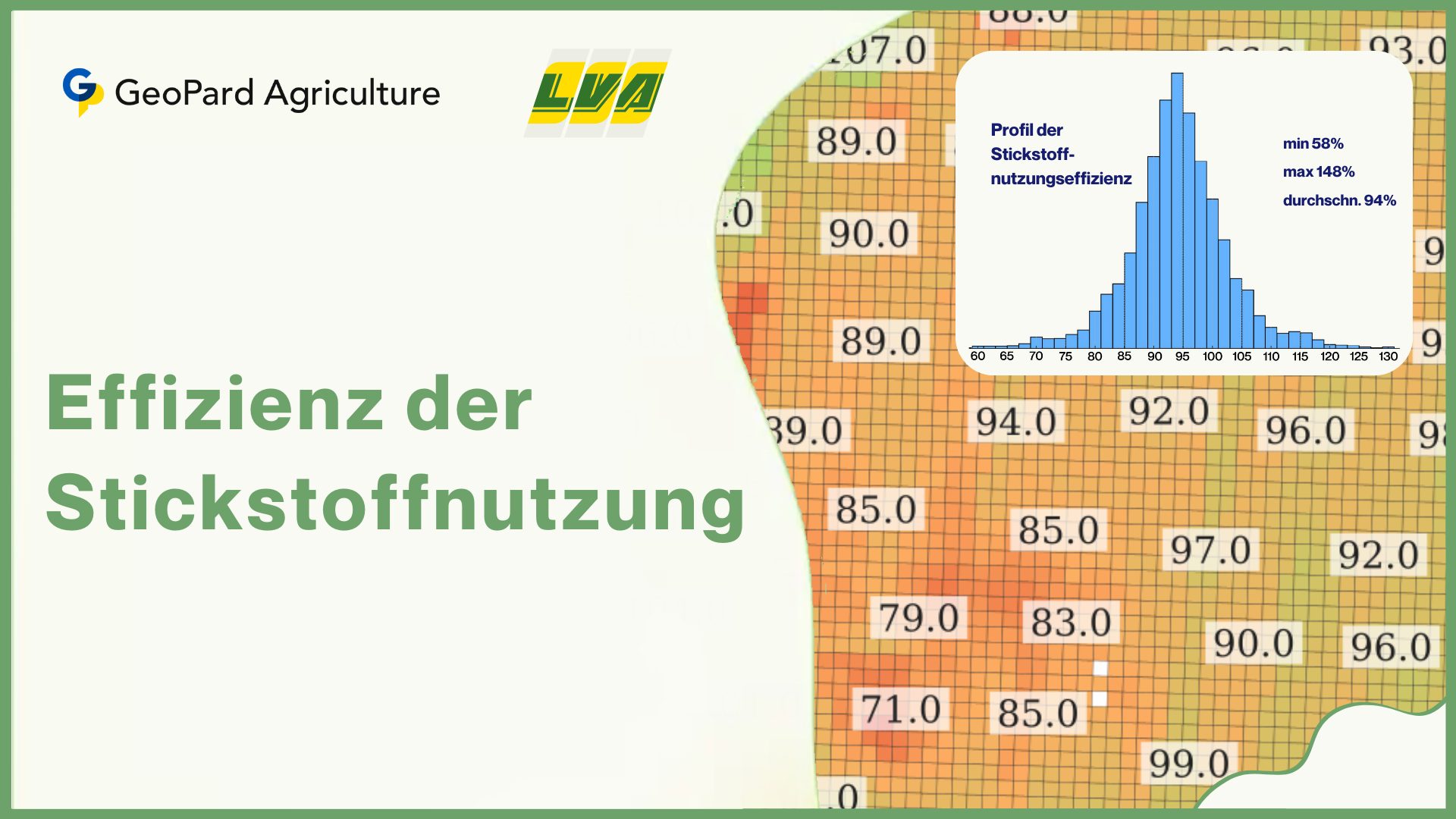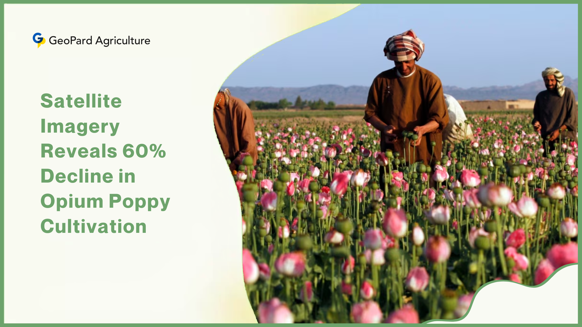
In the northeastern state of Manipur, a significant decline in opium poppy cultivation has been recorded, marking a notable victory in the ongoing battle against the illicit trade. According to data from the Manipur Remote Sensing Applications Centre (MARSAC), the total area under opium poppy cultivation has plummeted by 60% since 2021.
This remarkable decrease, revealed through satellite imagery technology and ground verification, sheds light on the effectiveness of concerted efforts by both the state government and law enforcement agencies in curbing this menace.
MARSAC, an autonomous government institution operating under the planning department, has been instrumental in visualizing geographic data pertaining to opium poppy cultivation in Manipur.
Utilizing advanced satellite imagery technology provided by reputable entities such as the Indian Space Research Organisation (ISRO) and NASA, MARSAC meticulously mapped opium poppy cultivation across Manipur between September 2021 and January 2024, spanning multiple crop cycles.
The latest report submitted by MARSAC to the Manipur government in early March not only quantifies the decline in opium poppy cultivation but also provides empirical evidence of the impact of the state’s “war on illicit trade” campaign spearheaded by Chief Minister N Biren Singh.
The campaign, initiated in June 2018, has seen a sustained drive to eradicate opium poppy cultivation, resulting in tangible progress over the years.
One of the key findings of the report is the substantial reduction in opium poppy cultivation clusters across the state. During the survey period, MARSAC identified these clusters in various districts of Manipur, with notable decreases observed in areas such as Kangpokpi, Churachandpur, and Tamenglong.

The concerted efforts of law enforcement agencies, particularly in remote border regions susceptible to trafficking, have played a pivotal role in disrupting the supply chain of illicit drugs.
While the exact factors contributing to the decline in opium poppy cultivation are not explicitly outlined in the report, senior officials in the forest department and the NAB attribute it to the sustained enforcement actions undertaken in recent years.
The heightened vigilance in border areas, coupled with the systematic destruction of poppy fields, has undoubtedly deterred illicit activities and disrupted the profitability of opium cultivation.
The significance of satellite imagery technology in monitoring and combating opium poppy cultivation cannot be overstated. By leveraging resources such as the LISS-IV satellite imagery from ISRO and multispectral instruments like Sentinel-2A, MARSAC has been able to accurately identify and track poppy plantations across Manipur.
This technology, complemented by ground verification efforts, ensures the reliability and accuracy of the data presented in the report.
Furthermore, the MARSAC report highlights the adverse environmental impacts associated with opium poppy cultivation, including deforestation, soil erosion, and loss of biodiversity. While these consequences underscore the urgent need for sustainable alternatives, it is imperative to address the root causes driving farmers to engage in illicit cultivation practices.
The socio-economic dynamics of opium poppy cultivation reveal a complex interplay of factors, with poverty and lack of viable alternatives often driving marginalized farmers into this illicit trade.
Efforts to combat opium cultivation must therefore be accompanied by comprehensive initiatives aimed at providing farmers with alternative livelihood options, as highlighted by experts and researchers familiar with the situation in Manipur.
In conclusion, the significant decline in opium poppy cultivation in Manipur reflects a promising step towards addressing the challenges posed by the illicit trade. The collaborative efforts of government institutions, law enforcement agencies, and civil society stakeholders have yielded tangible results, underscoring the importance of sustained intervention strategies and holistic approaches to tackle this multifaceted issue.
Satellite Imagery