Posnetki planetov (dnevni, ločljivost 3 m) za ustvarjanje upravljavskih con

Dostop do posnetkov planetov je postal enostavnejši, hitrejši in cenovno dostopnejši z GeoPard Agriculture. Od avgusta 2022 GeoPard ponuja možnosti iskanja in analize samo zahtevanih slik planetov iz uporabnikovega izbranega časovnega obdobja.

Torej uporabnik GeoPard zahteva samo želene slike planetov in jih lahko uporablja v analitičnem orodju GeoPard.

Slike planetov se raztezajo Sentinel in Landsat pokritosti (privzeto zagotovljene) in jih je mogoče mešati z drugimi podatkovnimi sloji (nabori podatkov o strojih za žetev/škropljenje/setev, topografski profil) prek obstoječih Večplastno, Večletno, in Orodja za enačbe


Posnetki planetov za ustvarjanje upravljavskih con


Planet je največje omrežje satelitov za opazovanje Zemlje, ki zagotavlja skoraj dnevni globalni nabor podatkov in omogoča visokoločljivostne in visokofrekvenčne satelitske posnetke.

Območja upravljanja na podlagi posnetkov Planet Scope (ločljivost 3,5 m).

Preberite več o GeoPard / Partnerstvo Planet.

Kaj je posnetek planetov in njegova uporaba za ustvarjanje upravljavskih con?

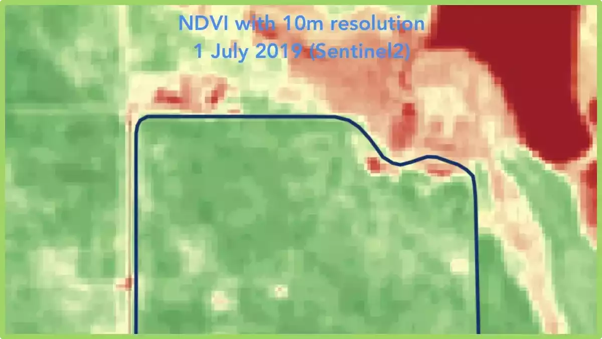
Nanaša se na satelitske posnetke, ki jih zagotavlja Planet Labs, zasebno podjetje, ki upravlja floto majhnih satelitov, imenovanih Doves. Ti sateliti dnevno zajemajo slike zemeljske površine v visoki ločljivosti. Izraz “ločljivost 3 m” pomeni, da vsaka slikovna pika na sliki predstavlja območje na tleh velikosti 3 × 3 metre. Ta raven podrobnosti omogoča podrobno analizo in spremljanje različnih značilnosti in sprememb na zemeljski površini.

Ko gre za ustvarjanje con upravljanja, so lahko posnetki planetov z dnevno ločljivostjo 3 m zelo koristni za različne panoge in aplikacije, kot so:

  • KmetijstvoPosnetki visoke ločljivosti lahko pomagajo pri ustvarjanju območij upravljanja v kmetijstvu, kjer različna območja polja lahko zahtevajo različne obdelave, kot so namakanje, gnojenje ali zatiranje škodljivcev. Z analizo posnetkov lahko kmetje prepoznajo vzorce, povezane z zdravjem pridelka, vlažnostjo tal in drugimi dejavniki, kar jim omogoča boljše odločitve o dodelitvi virov.
  • Upravljanje okolja: Satelitske posnetke je mogoče uporabiti za prepoznavanje in spremljanje okoljsko občutljivih območij, kot so mokrišča, gozdovi in habitati prostoživečih živali. Te informacije je mogoče uporabiti za ustvarjanje upravljavskih con, ki varujejo ta območja in zagotavljajo trajnostne prakse rabe zemljišč.
  • Urbanistično načrtovanje: Posnetki visoke ločljivosti lahko urbanistom pomagajo prepoznati območja rasti, vzorce rabe zemljišč in razvoj infrastrukture. Te informacije se lahko uporabijo za ustvarjanje upravljavskih con, ki usmerjajo prihodnji razvoj in zagotavljajo učinkovito rabo virov.
  • Obvladovanje nesreč: Satelitski posnetki lahko pomagajo pri prepoznavanju in spremljanju območij, ki so nagnjena k nesrečam, kot so poplavna območja ali žarišča požarov v naravi. Ustvarjena so lahko območja upravljanja za vzpostavitev evakuacijskih poti, dodelitev virov za odzivanje na nesreče in oblikovanje politik rabe zemljišč, ki zmanjšujejo tveganje prihodnjih nesreč.
  • Upravljanje naravnih virov: Posnetki visoke ločljivosti lahko pomagajo pri spremljanju in upravljanju virov, kot so voda, minerali in gozdovi. Z identifikacijo območij z visoko vrednostjo virov ali območij z omejenim številom virov je mogoče ustvariti območja upravljanja, ki zagotavljajo trajnostno rabo in ohranjanje teh virov.

Skratka, posnetki planetov z dnevno ločljivostjo 3 m so dragoceno orodje za ustvarjanje upravljavskih con na različnih področjih, saj zagotavljajo ažurne in podrobne informacije, ki lahko odločevalcem pomagajo optimizirati dodelitev virov in zagotoviti trajnostne prakse rabe zemljišč.


Pogosta vprašanja


1. Kaj lahko pomaga ugotoviti uporaba slikovnega gradiva?

Uporaba posnetkov lahko pomaga vzpostaviti učinkovitejši in uspešnejši kmetijski sistem. Z uporabo tehnologij, kot so droni ali satelitski posnetki, lahko posnetki zagotovijo dragocen vpogled v zdravje pridelkov, stanje tal in potrebe po namakanju.

Pomaga pri prepoznavanju problematičnih področij, kot so napadi škodljivcev ali pomanjkanje hranil, kar kmetom omogoča sprejemanje ciljno usmerjenih ukrepov. Poleg tega posnetki pomagajo pri spremljanju rasti in razvoja pridelkov, kar omogoča natančno odločanje in maksimiranje donosa. 

Kako satelitski posnetki pomagajo pri spremljanju pridelkov

Satellite imagery is one of the most versatile functions that can be implemented in agricultural production in order to improve the decision-making process. Making decisions, based on a large quantity of data, can help the farmers, agronomists, or advisors to comprehend the situation and the processes that are occurring in the agricultural fields that are subject to monitoring.

What is satellite imaging?

Satellite imaging, also known as satellite remote sensing, is the process of using satellite imagery to gather information about the Earth’s surface, atmosphere, and oceans. This technology involves the use of satellites equipped with specialized sensors and cameras that can capture high-resolution images of the Earth from space.

The images captured by the satellites can be used for a variety of applications, including monitoring weather patterns, tracking changes in the environment, mapping land use and vegetation, and assessing the impact of natural disasters. They can also be used for military and intelligence purposes.

Satellite imaging with its benefits can present situations that can not be seen with regular observation. Regular observations can be very demanding in the sense of the quantity of implemented workforce, finance, and time.

Even with regular observations made during the growth period of the crops, there are several things that can not be seen with the naked eye, such as the early progression of disease and damage induced by the pests that ultimately result in chlorophyll degradation on a cell level.

With the integration and calculation of spectral bands invisible to the human eye, the growers and the advisors can easily visualize chlorophyll degradation before the visible disease or pest damage symptoms on the plants.

Multispectral Satellite Imagery

These advantages in crop monitoring are beneficial with nowadays technologies, allowing implementation of such information to be integrated into geographic information systems, resulting in creating a prompt and quality set of data ready to be utilized in the decision-making processes regarding agricultural production systems.

Besides making information-based decisions, satellite imagery can be used for reporting, record-keeping, and integrating with different sets of data (disease and pest models, yield maps, pest monitoring, fertilization maps and etc,) in order to create an even more functional system of crop monitoring and the way how the farmer or other professionals see the progress of the crops during their growing period.

How are satellite imagery used in farming?

The images can be used to model and calculate spectral indices which later are equated to be used for visualization in the form of color synthesis, either in the visible part of the spectrum or by including other wavelengths. Properly selected color synthesis can reveal crop growth, stress or soil erozija displayed with different colors.

Spectral indices are combinations of spectral reflection of two or more wavelengths to show features of interest. Crop indices are most commonly used in agriculture, but the indices are used for the identification of burned areas, other artificial characteristics, water, and other geological features.

Hyperspectral Satellite Imagery

Useful spectral indices in crop production include:

  • NDVI (Normalized Difference Vegetation Index).
  • EVI (Enhanced Vegetation Index).
  • RENDVI or NDRE (Red Edge Normalized Difference Vegetation Index).
  • GNDVI (The Green Normalized Difference Vegetation Index).
  • MSI or NDWI (Moisture Stress Index).
  • LAI (Leaf Area Index).

NDVI is one of the most used indices and is frequently used to review the initial state of a crop. Other indexes work with certain characteristics, so the results are specific to related to specific agricultural sites, it is important to work with the history of land vegetation.

NDVI (Normalized Difference Vegetation Index)

This index is a measure of green vegetation and is generally the most widely used index. The leaves reflect infrared light (NIR) and use only visible light for photosynthesis. This means that a healthy plant with a good photosynthesis rate can be analyzed by comparing NIR with visible red light.

Unhealthy vegetation will reflect more visible light and lower NIR. Healthy vegetation will reduce some of the visible light that falls on it. However, NDVI is sensitive to the effects of soil (light and color), cloud cover, and shade. Also, the NDVI values can be incorrect in a situation with dense vegetation.

EVI (Enhanced Vegetation Index)

This index is the standard for the moderate resolution spectra – an instrument used on the Terra and Aqua satellites. EVI presents an alternative to NDVI which refers to some of its deficiencies, e.g., soil and atmospheric constraints, by optimizing the reflectivity of leaf vegetation.

It uses the blue part of the visible spectrum for signal correction, lowering the effects of the abovementioned constraints including the scattering of electromagnetic radiation by aerosols.

RENDVI or NDRE (Red Edge Normalized Difference Vegetation Index)

This index is based on the standard NDVI index, but with modifications. RENDVI is very useful in precision agriculture, forest monitoring, and the detection of crop stress.

Its effectiveness is due to the inclusion of wavelengths that fall into the red end band, rather than wavelengths that correspond to the value of reflection and absorption. It is especially convenient for detecting small changes in the vegetation condition.

GNDVI (The Green Normalized Difference Vegetation Index)

This index is similar to the NDVI index and measures the reflection of the light in the green part of the spectrum in the wavelength range of 540 to 570 nanometers, instead of the red part of the spectrum. This makes the index more sensitive to the chlorophyll content in the green parts of the crops.

MSI (Moisture Stress Index)

This index is sensitive to the increase in water content in the leaves. The MSI index is used to detect water scarcity stress and is a good indicator of crop conditions often used for crop modeling, fire analysis, and ecosystem physiology. High values ​​indicate water stress and lower water content.

LAI (Leaf Area Index)

This index is used to estimate leaf area and to predict plant growth and yield.

Types of crop satellite imagery

Satellites and technology providers Type of satellite imagery Repeat cycle Spatial resolution
Landsat4-9 RGB, MULTISPECTRAL, PANCHROMATIC 8 days 15, 30, 100 m
Sentinel-2, RGB, MULTISPECTRAL 5 days 10 m
Planet Scope RGB, MULTISPECTRAL Daily 3-4 m
Planet SkySat PANCHROMATIC, MULTISPECTRAL Daily 0.5, 0.71-0.82 m
Airbus Pleiades MULTISPECTRAL Daily 0.5 m
Pleades NEO PANCHROMATIC, MULTISPECTRAL 40 minutes after request 0.3 m
ICEEYE SYNTHETIC APERTURE RADAR Daily 0.25 m
Hyperion HYPERSPECTRAL N/A 30 m
Prism HYPERSPECTRAL N/A 0.3 m

Satellite imaging use-cases

Here are some important use of satellite images in crop monitoring:

Thermal Imagery

The heat emitted by ground-level objects can be seen in thermal photography taken from the air, which also reveals temperature variations that correspond to crop stress. The removal of unnecessary elements, such as pivot equipment, from the image through calibration and image correction prevents data skew.

Cooler regions show purple and warmer regions appear yellow in the final imagery. Thermal imaging is helpful for finding leaks, jams, and other irrigation problems since water cools vegetation. Thermal imaging aids growers in identifying pre-symptomatic disease and pest pressures and responding with more timely and focused interventions by revealing tiny changes in leaf surface temperature.

Soil moisture

Agriculture must take into account soil moisture. For precision farming applications (at the scale of individual fields) and with the anticipation of improving crop yield modeling, the availability of high-resolution soil moisture maps is especially crucial.

Due to the poor spatial resolution and shallow depth of the observations, soil moisture products generated from satellites have so far been employed sparingly in farm- or field-scale agricultural decision support. However, if it can deliver pertinent data on acceptable temporal and spatial dimensions, satellite-derived soil moisture is anticipated to have much potential.

Resolution

High-resolution satellite imaging from low-orbit satellites has recently become more developed and accessible, providing another potential for phenotyping applications. This paper illustrates how satellite photography is used in crop phenotyping and agricultural production, and it identifies plant features that can be assessed using high-resolution satellite data.

The paper covers the benefits of using satellite-based phenotyping in crop breeding programs as well as the drawbacks, such as cloud blockage. It also explores potential uses for high-resolution satellite imaging as a phenotyping tool in the future.

In order to help plant breeders choose high-yielding, stress-tolerant varieties that can help meet global food demand while coping with climate change, high-resolution satellite imagery can be used as a phenotyping tool for the evaluation of crop varieties.

Satellite monitoring

Applications of satellite imagery

GeoPard capabilities and satellite imaging applications offer the users to visualize, normalize, analyze and derive insights directly from the agricultural plots in order to improve crop production. This data utilization can be done with the help of ready-to-use GeoPard algorithms or by creating your own algorithms to make them useful for agronomy.

These algorithms allow evaluation of crop growth, stress, etc. (see photo) or even create prescription maps: for example Nitrogen VR application maps, Crop Protection spraying application maps.


Pogosta vprašanja


1. Kako pridobiti satelitske posnetke kmetije?

To get it for your farm, research providers, sign up, and access their database or portal. Specify your farm’s location and desired parameters to retrieve relevant images for agricultural monitoring.

2. Zakaj so satelitski posnetki koristni za razumevanje prehranjevalnih spletov?

It is helpful in understanding food webs due to its ability to provide a broad and comprehensive view of ecosystems. By capturing large-scale images of land and water bodies, it allows scientists to observe and analyze the spatial distribution of various habitats and resources.

This, in turn, aids in studying the interactions between different species, identifying key feeding relationships, and comprehending the flow of energy through food webs.

It helps unravel complex ecological dynamics, contributing to a deeper understanding of ecosystem functioning and conservation efforts.

3. How expensive is satellite imagery?

Its cost varies depending on several factors. These include the provider, resolution, frequency of acquisition, and extent of coverage needed. Prices can range from affordable options for low-resolution imagery to more expensive options for high-resolution and real-time monitoring.

Additionally, specialized services or customized data requests may incur additional costs. It is advisable to explore different providers and their pricing models to find a satellite imaging solution that aligns with your specific requirements and budget.

4. What is infrared satellite imagery? How to read it?

It captures the infrared radiation emitted by objects and surfaces on the Earth’s surface. It provides valuable insights into temperature variations and thermal patterns.

To read infrared satellite imaging, one must understand that warmer objects appear brighter in the image, while cooler objects appear darker. By analyzing these temperature variations, one can assess cloud formations, identify land and water temperature disparities, detect wildfires, and even monitor ocean currents.

Understanding the color scale and interpreting the brightness levels on the imagery helps in extracting meaningful information from infrared satellite images.

Napovedovanje pridelka z uporabo podatkov daljinskega zaznavanja v natančnem kmetijstvu

For crop yield prediction, we need to understand how much sunlight plants receive and how much water they need. Plant growth depends on these two factors, but many other factors affect plant growth such as temperature, humidity, and vrsta tal.

The quantity and quality of crops produced in the world is a major factor affecting food security. This is especially important in developing countries where agriculture is still an important part of the economy.

Remote sensing data can be used to estimate quantities of light received by plants and thus predict crop yield. Remote sensing data is a powerful tool for estimating crop yield. It provides information on the growing crops and their environment, allowing you to estimate crop production.

Remote sensing data is a form of data analytics in agriculture that can be used to predict yield before the harvest. This article explores everything you need to know about remote sensing data.

What is crop yield data in agriculture?

Crop yield data is information on the amount of crop produced by a farmer or farmer group. It includes the amount of crop harvested per hectare of land. This can be measured in tonnes, bushels, or any other unit of measurement depending on the crop.

Farm Yield data is important when it comes to agriculture because it can help farmers determine how much they should plant next season. In addition, yield data allows them to determine if there’s a problem with their crops that needs to be addressed.

Yield data can also be used to monitor progress toward global goals set by governments, non-governmental organizations, and other stakeholders.

In addition, yield data is used to identify strengths and weaknesses in farming practices and make recommendations based on this information. Yield data is useful in making informed decisions about many aspects of farming, such as:

Data analytics in precision agriculture

Seed selection: Choosing varieties and hybrids based on yield data can help ensure that fields are planted with the most profitable seeds available.

Pest management: By monitoring plant growth, yield data can help farmers determine when to introduce pest control measures. This can reduce the use of pesticides and increase profits.

Irrigation scheduling: Using information from yield monitors allows farmers to fine-tune irrigation scheduling, which helps conserve water and money while maintaining high yields.

What is remote sensing data?

Remote sensing is the science of acquiring information about an object or phenomenon without being in direct contact with the object and thus in a non-intrusive manner. It is used in agriculture to monitor crops, soil, and moisture conditions.

Remote sensing uses electromagnetic radiation (EMR) emissions such as those emitted by radio waves, microwaves, infrared, visible light, and ultraviolet light.

Remote sensing of crops provides a way to measure crop growth conditions over time. It also provides information on the state of crops at specific points in time and space. This information can be used to estimate crop yields and provide estimates of when the harvest should occur.

Remotely sensed data can be used to measure land-use changes, monitor crop growth, and farm yield, detect soil moisture and salinity levels, determine pest infestation levels, monitor environmental pollution levels, etc.

So, for example, if you’re walking through a field and looking at the plants, you’re collecting data about them. If you’re driving around in a helicopter or plane and looking at the plants from above, you’re collecting remote sensing data.

There are many different types of remote sensing techniques and devices used to collect this data: satellite images, aerial photos, radar systems, lidar, and more.

What is crop yield prediction?

Crop yield prediction is the process of estimating the potential or expected yield of a specific crop for a given area and growing season.

It involves analyzing various factors such as weather conditions, soil characteristics, crop genetics, and management practices to make informed predictions about the likely harvest.

It is important to note that crop yield predictions are subject to uncertainty due to the complexity of agricultural systems and the influence of unpredictable factors like pests, diseases, and extreme weather events.

While prediction models provide valuable insights, they serve as a tool to aid decision-making rather than providing absolute certainty.

How does it work?

The following data sources are combined to create a varied weighting on yield projection numbers based on the present cropping season circumstances in various regions.

Farmers Edge data scientists combine these data sources with the most recent advances in machine learning to update yield forecast estimates whenever a major yield component is disrupted.

1. Preseason data

Preseason data must be accurate to lay the groundwork for crop yield prediction. This information is available before the crop is planted, and it lays the stage for the first yield prediction readings.

Data such as a field’s location, current and previous crops, field-specific weather months before planting or seeding, soil test information and data, and regional weather trends over the last decade are all combined to provide insight into how to start the season with accurate yield numbers to anticipate.

2. In-season data

In-season data provides insight into variables that affect farm yield throughout the growing season after the foundation has been laid.

Farmers Edge on-farm weather stations give field-centric data that enhances these datasets by delivering expected and predicted values that are stored and then reset when data comes in each day, advancing the models.

Other in-season data, like fertilizer application, is also taken into account during the season, whether planned or not, to improve field diagnostics and offer forecast yield values.

3. Crop-specific data

Farmers Edge’s wide network of local agronomists may also provide crop-specific data during the growing season.

Farmers Edge agronomists have identified crop-specific data that impacts yield during a growing season, including water content during major growth stages or hours above cardinal temperatures for crops during key yield determining periods, for the five main crops in yield prediction (corn, canola, lentils, soybeans, and wheat).

4. Crop and field imagery

High-resolution satellite imagery is used to set NDVI crop health values on fields fast and precisely, allowing researchers to look for erroneous results or regional concerns with crops that could affect yield.

These regional trends can be used to determine if areas are on track for forecast or whether environmental factors have distorted the crop yield prediction values.

5. Histogram data

Farmers Edge Yield Prediction models use big statistics to find different distributions in field images over time, which then offers clarity to a convolutional neural network that can use these modifications to forecast yield across large areas, such as the United States or Canada, as imagery changes over time.

What is remote sensing data in agriculture?

It’s not simple to anticipate production before the harvester runs through the field, but the Farmers Edge team is thrilled to provide producers with farm yield predictions based on complete and accurate statistics.

Each data source has a weight in crop yield prediction, which can be changed based on the model parameters.

How to increase farm yield with precision technologies?

Farm owners have debated and worked on raising agricultural yields for generations. Some of the methods discovered were effective, while others were ineffective.

In addition to the invaluable experience of earlier generations of farmers, the agriculture industry may now profit from modern scientific and technological advancements.

Let’s take a look at the most common ways for farmers to boost yields and how previous experience and new technology can be utilized to boost agricultural productivity.

1. Proper irrigation

Farmers that want to boost their average crop output per acre on their farms need a well-designed irrigation system. Providing the right amount of water to the plants has a direct impact on their development and, as a result, agricultural yields.

Weather forecasts are crucial for effective irrigation of farmlands. Hyper-local weather forecasting is now possible thanks to today’s technologies, which include customized programs and software for farmers.

It makes precision irrigation possible by allowing farmers to prepare ahead of time and schedule irrigation of their crops most exactly and efficiently possible.

2. Soil testing and its quality

One of the most important factors affecting crop yields is soil quality or fertility. Aside from agricultural production, soil quality has an impact on how much it costs a farmer to cultivate a certain plant, as some of them require specific ratios of specific elements in the soil, such as mineral particles, organic matter, water, and air.

Farmers must regularly monitor soil conditions on their land plots to achieve higher agricultural yields. Kolobarjenje is one of the most effective techniques to keep the soil healthy, among other things.

Plant rotation on a specific field plot avoids soil fatigue and interrupts insect cycles, resulting in higher agricultural output and, as a result, higher average farm yield per acre.

3. Quality of seeds

The quality of seeds used by farmers to sow their fields has an impact on agricultural production. As a result, agrarians are advised to sow only certified seeds that have passed all necessary quality controls on their farmlands to increase agricultural yield.

Certified seeds may be more expensive than uncertified seeds, but the result will be worth it because seed quality is one of the most important elements affecting crop productivity.

Aside from that, using only high-quality seeds is one of the most environmentally responsible ways to boost crop productivity. A farmer can examine the quality of specific seeds by contacting a relevant seed business and arranging customized trials on a specific parcel of land if necessary.

Aside from that, it’s crucial to understand that seed quality isn’t permanent or unaffected. From the moment they are sown in the earth, seed grains require protection. One of the seed treatment strategies used to achieve this is seed coating.

It is the technique of encasing seed grains in exterior materials to improve their properties (weight, size) and/or providing them with active chemicals (micronutrients, microbial inoculants, growth regulators, and so on) to protect them from plant diseases and enhance their growth.

4. Smart application of fertilizers

Fertilizers are designed to nourish different types of soil, enhance plant growth, and increase harvests, but their use should be balanced and judicious. Overuse of fertilizers can have a severe impact on soil quality and, as a result, agricultural productivity.

Various regions of a field may require different levels of soil fertilization, so the best approach is to use fertilizers selectively, according to the demands of different field zones. This precise approach to field fertilizing keeps the soil healthy, resulting in higher average yields per acre.

A Crop Monitoring software is one of the technology options in this context. It contains a field zoning tool that separates farmland into 2-7 zones based on satellite photography, identifying places that require more attention than others.

Growers frequently employ precision technology as one of the most environmentally friendly ways to boost it.

5. Crop protection methods

Agriculturists who want to boost yields must look after their plants throughout their growth and until the end of the growing season. Farmers use a variety of compounds to reduce the influence of weeds, pests, and diseases on crop productivity, depending on the situation.

Herbicides, insecticides, desiccants, plant growth regulators, fungicides, adjuvants, and other chemicals are common examples. Crop protection can be done in a variety of ways. Weed/pest control and plant disease control are two of the most important.

6. Plant disease prevention and management

Plant infections are another significant hazard to a grower’s agricultural performance. Farmers can use a variety of plant disease prevention and management methods, like choosing disease-resistant or disease tolerant varieties, treating seeds with fungicides, and applying pesticides and other similar substances to developing plants, depending on the type of plants to be grown on a field.

Agrarians should pay extra attention to when they use these or other tactics so that they have the most impact. It’s necessary to keep in mind that timely plant protection is critical for the farm yield per acre indication — the earlier a problem is recognized, the faster and easier it will be resolved, and the lesser fields acres will be impacted.

7. Weed and pest management

During the growing season, farmers’ primary challenges are weed control and pest management. A single weed, for example, can produce over 10 million weed seeds, which, if not controlled promptly, can significantly reduce yields on a given field and cause difficulties for years. Agrarians must also take a holistic response to pest infestations.

Farmers must constantly be ready to respond to pest infestation issues promptly because pests are highly adaptive and fast-reproducing organisms that might jeopardize the produce on specific farmland.

Crop yield prediction is a major concern for farmers as it directly affects their profit margin. If a farmer knows how much yield he can expect from his land, he can plan his crops accordingly and increase his profit margin. This is why it is important to predict farm yield accurately before planting any crop on a particular land.

Crop yield prediction with GeoPard Agriculture Tools

It has been an important issue in agronomy since ancient times. It is critical to food security, especially at times of drought, floods, or other natural disasters.

Crop yield prediction is also used by farmers to make decisions about when to plant and harvest crops based on soil moisture content, pest infestations, and other factors such as weather conditions and fertilizer requirements.

To make more informed decisions and improve growing efficiency with Farm Yield Data, click here to request a demo now.


Pogosta vprašanja


1. How do farmers increase their crop yield?

Farmers increase crop yield through soil management, efficient irrigation, crop rotation, and pest and weed control. These practices optimize soil fertility, water availability, and minimize pests and diseases, resulting in higher crop productivity.

2. How to calculate crop yield per hectare/plot?

It can be measured through various methods and factors. One common approach is to physically harvest a representative sample of the crop from a given area and weigh it. This weight is then extrapolated to estimate the total yield of the entire field or farm.

For example, if the sample weighs 100 kilograms and the field area is 2 hectares, the crop yield per hectare would be 50 kilograms.

Additionally, advanced technologies such as remote sensing and satellite imagery can be used to assess crop health, vegetation indices, and biomass, providing valuable insights.

Other factors like grain quality, size, and market value are also taken into account when measuring it. For example, if the sample weighs 100 kilograms and the field area is 2 hectares, the crop yield per hectare would be 50 kilograms.

3. How do you estimate the crop yield prior to harvest?

Estimating crop yield prior to harvest can be done through a combination of methods.

One approach is using crop-specific growth models that take into account factors such as planting date, weather conditions, and crop health to predict potential yield. A

Another method is using remote sensing techniques, such as satellite imagery or drones, to assess crop vigor and biomass.

4. Which type of farming system yields healthier grains?

Organic farming systems are often associated with healthier grains. Organic farming avoids the use of synthetic pesticides, herbicides, and genetically modified organisms (GMOs). Instead, organic farmers rely on natural fertilizers, crop rotation, and biological pest control methods.

These practices contribute to the production of grains that are free from chemical residues, potentially higher in essential nutrients, and have lower levels of pesticide contamination.

However, it’s important to note that the specific health benefits of grains can vary depending on factors such as soil quality, crop variety, and post-harvest handling practices.

5. How does pesticides increase crop yield?

Pesticides can increase it by protecting plants from various pests, diseases, and weeds. They help control or eliminate harmful insects, fungi, bacteria, and other organisms that can damage or destroy crops.

By reducing the impact of pests, pesticides allow plants to grow more vigorously, utilize nutrients efficiently, and allocate more resources towards productive growth. \

Hyperspectral imagery for Agriculture. Grant from the state of North Rhine-Westphalia.

We are glad to announce that the “Artificial intelligence framework for quantitative estimation of soil properties using hyperspectral satellite imagery” project was selected for partial funding by the Ministry of the Environment of North Rhine-Westphalia and the European Union under the REACT-EU InnovationUmweltwirtschaft.NRW program. The grant is funded by the European Regional Development Fund / Europäischen Fonds für regionale Entwicklung (EFRE).

the European Regional Development Fund

The use of artificial intelligence and statistics in this project made it possible to determine the correlation between hyperspectral and soil data (e.g., N, pH), facilitating a more precise and scalable approach to soil analysis. The forthcoming launch of hyperspectral satellites with frequent revisit intervals and seamless access to new imagery without delays presents several advantages, particularly in nutrient management for sustainable agriculture. The technology helps assess nutrient content and availability in the soil, allowing farmers to tailor fertilisation strategies. This leads to better nutrient uptake by plants, reduced environmental impact, and cost savings.

What is Hyperspectral imagery?

Hyperspectral imagery is a powerful remote sensing technique that captures the electromagnetic spectrum with high spectral resolution.

Unlike traditional satellite imagery, which typically consists of three to four bands (red, green, blue, and sometimes near-infrared), hyperspectral imagery collects hundreds to thousands of narrow spectral bands across the visible, near-infrared, and shortwave infrared regions. Each band provides unique information about the surface properties of the imaged area.

It is acquired using sensors mounted on airborne or spaceborne platforms. These sensors use spectrometers to measure the intensity of reflected or emitted radiation across multiple narrow bands.

By collecting a wide range of spectral data, hyperspectral sensors can detect subtle differences in the spectral signatures of various materials, allowing for highly detailed and precise analysis.

Applications of Hyperspectral Imagery

  • Environmental Monitoring: It plays a vital role in monitoring and assessing the health of ecosystems. It helps identify vegetation stress, monitor land cover changes, detect invasive species, and measure water quality parameters like chlorophyll concentration or turbidity in lakes and rivers.
  • Agriculture: It aids in precision agriculture by providing detailed information about crop health, nutrient content, moisture levels, and disease detection. Farmers can make data-driven decisions regarding irrigation, fertilization, and pest management, resulting in optimized crop yields and reduced environmental impact.
  • Geology and Mineral Exploration: It is instrumental in mapping geological formations, identifying mineral deposits, and characterizing rock types. It helps geologists detect alterations in mineral composition and map potential areas for exploration, contributing to more efficient and targeted mining activities.
  • Forestry: It assists in forest management and monitoring. It enables the identification of tree species, quantification of forest biomass, detection of tree stress, and assessment of wildfire damage. This information aids in sustainable forest management, biodiversity conservation, and early warning systems for forest fires.

Benefits of Hyperspectral Imagery

Its main advantage lies in its ability to provide detailed spectral information, enabling the discrimination of materials with high accuracy.

This leads to improved classification and mapping of land cover types, enhanced identification of specific substances, and better understanding of environmental processes.

Hyperspectral data can also be analyzed using advanced algorithms and machine learning techniques to extract valuable insights and automate image interpretation.

Sistem za daljinsko spremljanje pridelkov: Kako deluje?

A remote crop monitoring system in precision agriculture refers to the use of various technologies and tools to monitor and manage crops from a distance. This approach leverages data collection, analysis, and communication technologies to make informed decisions about crop health, irrigation, fertilization, and overall farm management.

Farming is not left behind in the 21st century where everything is going digital. As you read this article, several farmers spread across the globe are already using tech to perform several tasks in their fields such as monitoring plant humidity, soil conditions, general health, temperatures, and even many more the use of sensors.

By embracing technology, farmers are enjoying the benefits of having accurate statistics as compared to the old days when they used guesses works and intuitions to make choices. This helps them in making better judgments that result in increased harvests.

What is crop monitoring system?

Crop monitoring refers to the process of systematically observing, assessing, and collecting data about crops throughout their growth cycle.

It involves regular and systematic observation of crops to gather information about their health, growth, and development.

Its goal is to make informed decisions regarding crop management practices, optimize resource utilization, and maximize yields. It typically involves the following activities:

  • Visual Inspection
  • Phenological Observations
  • Soil Monitoring
  • Weather Monitoring
  • Sensor-Based Monitoring
  • Data Analysis

By monitoring crops, farmers can proactively address problems, optimize resource allocation, and make informed decisions to improve overall crop health, yield, and profitability. It is an essential component of precision agriculture, enabling farmers to practice targeted and sustainable crop management.

Smart crop monitoring system: How does it work?

Its main goal is to ensure that farming becomes easier and more profitable as compared to traditional methods. From displaying data about the fields all the way to weather forecasts, below is all that you may want to know about remote crop monitoring and related topics.

A smart crop monitoring system incorporates various technologies to collect, analyze, and utilize data for efficient crop management. Here’s a breakdown of how it typically works:

1. Sensor Deployment

The system begins by deploying sensors in the field. These sensors can measure parameters such as soil moisture, temperature, humidity, nutrient levels, and light intensity.

They may also include weather sensors to capture data on rainfall, wind speed, and solar radiation. The sensors are strategically placed throughout the field to gather representative data.

2. Data Collection

The deployed sensors continuously collect data from the field. This can be done using wired or wireless connections.

Wireless sensors are commonly used as they provide flexibility and ease of deployment. The collected data is sent to a central system for further processing and analysis.

3. Data Transmission

Wireless sensors transmit the collected data to a central hub or gateway. This can be done using various wireless communication technologies such as cellular networks, Wi-Fi, or dedicated radio systems. The data transmission can be in real-time or at regular intervals depending on the system’s configuration.

4. Data Storage and Processing

The collected data is stored in a database for further analysis. Advanced data processing techniques, including machine learning algorithms and statistical models, are applied to the data to extract meaningful insights and patterns. This analysis helps identify correlations, trends, and anomalies in the crop conditions.

5. Decision Support and Alerts

Based on the analyzed data, the system provides decision support to farmers or agronomists. It generates alerts and notifications regarding critical events, such as soil moisture levels dropping below a threshold or the presence of pests or diseases.

These alerts are delivered through web-based dashboards, mobile applications, or email/SMS notifications, enabling timely interventions.

6. Visualization and Reporting

The system presents the analyzed data in a user-friendly manner through visualizations and reports. Graphs, charts, and maps are often used to convey information about crop health, growth patterns, and environmental conditions. This helps farmers interpret the data easily and make informed decisions.

7. Automation and Control

In some cases, it can be integrated with automated irrigation systems, fertigation systems, or machinery.

Based on the collected data and analysis, the system can automatically control irrigation schedules, adjust nutrient application rates, or activate pest management measures.

This integration allows for real-time, data-driven decision-making and precise control over crop management practices.

The ultimate goal of a smart crop monitoring system is to optimize resource utilization, improve crop productivity, and reduce costs by providing farmers with accurate and timely information for decision-making. By leveraging technology, such systems enable more efficient and sustainable crop management practices in modern agriculture.

The importance of a remote crop monitoring system

Among the most important tasks that are always done for good yields is the monitoring of crops. Since plants are constantly monitored, it ensures that they grow in the best conditions, and in case of any anomalies, it is corrected on time hence reducing the devastating impending impact.

As a farmer or agriculture enthusiast, it is worth noting that it is currently a must-do for one to expect better massive harvests and those that are of higher quality since most of the drawbacks are settled early enough.

Since monitoring crops is one of the pillar requirements for a good harvest, one needs to go for special training. Special training doesn’t mean one needs to hold a master’s or bachelor’s degree but only needs to understand how to coordinate, monitor and even weigh the obtained results. Through this, you will be able to make better decisions based on accurate diagnosis and later best quality yields.

When choosing to monitor your crops, you need to know that apart from prevention of infestations and spread of pests, diseases and even weeds are always under control hence no devastating effects that lower the performance and even the quality of the final products.

Are you aware that crops are always exposed to strange threats yearly due to mutations and transformations in the biological components of the pests hence usually choosing one similar method of treating them means you are mistaken and need to change tactics every time?

For that reason, monitoring crops is perceived as a serious task that needs more responsibility and one that should not be degraded.

Whenever one is monitoring fruit crops such as pears and even apples, when using an Integrated Pest Management Programme, it is advisable not only to track changes in trees but also to check on the weather in the area that affects them.

This enables you to have a list of possible pests that may pose a threat to the growth of trees. Using systematic visual monitoring of the orchard block will work whenever you want to reduce the cost and your time from planting season to the harvesting season.

Climate and pests

The questionable part when analyzing the influence of climate is simply that some pests can feed on it and later be toxic to agents to crops so fast. Basically in agriculture, many farmers always lack awareness hence noticing when it is too late when their crops are already massively infested by pests.

The better part of this is that pests always do react predictably to the climate hence a perfect strategy can be hatched to avoid another pest attack and also prevent them in the future.

Despite monitoring being done more frequently, vegetable and fruit farmers always get to know the presence of pests or any threat a little late. This shows how important it is to monitor climatic factors that eventually turn out to be earlier signs of the emergence and pest infestation.

Block crop monitoring

Many ways can be used to monitor crops, and one of them is through visual monitoring using blocks that enable you to analyze trees that have similar characteristics based on their variety, age, and, even physical condition.

The idea behind visual monitoring is to have blocks that act as signs and those that can be studied like they were a unit and not separately since it is a way that is used by several farmers across the globe and that horticultural experts always have limited time for them to review each of the blocks arranged in the field.

importance of a remote crop monitoring system

Certain attention needs to be paid during the selection of the most appropriate block. This is because the block that is chosen needs to have all the history of the pests so that the best treatment and prevention can be applied to protect the growth of other trees.

You do not have to have large equipment, tools, and even complex methods to monitor your crops. One of the best ways to go is simply to do a meticulous and extensive visual examination that enables you to notice the different types of škodljivci present in the trees.

This can be always completed using a common lens, however, experts will always use more complex equipment such as a binocular microscope. This enables them to count and even identify mites and thrips.

Temperature of crops

For one to accurately measure the temperature when monitoring crops, he or she can choose to use a simple thermometer after finding out about simple information. Besides that, you may also choose to use a maximum to a minimum thermometer that is very common among rural suppliers and record extra information.

It is also worth noting that the thermometer needs to be placed on the orchard and ensure that it is not exposed to direct sunlight. You may also add a data logger to record more accurate weather information.

For data loggers, you may also choose to use those that have the potential of measuring the temperature, rain, humidity, and even the humidity of the leaves.

For you to put aside trees that will not be studied with those in the blocks that will act as indicators, for you to be able to differentiate them, you simply need to mark them using acrylic paint or even adhesive tape.

Application of an Integrated Pest Management vouches for selecting and marking flowers, buds, and fruits randomly to monitor each one of the trees.

After about the duration of one to two weeks, at the time that the fruit is developing, farmers need to spend ten to twenty minutes for every two and a half acres strictly managing the fruits, flowers, and buds that are marked searching for any signs that may show the presence of one or even more pests in the crop.

Whenever a pest is found in the crops, it needs to be recorded fast and also in a detailed way in the log made exactly for this kind of data.

Zaključek

All our expert team of agronomists are professionals in a range of branches of agriculture and are also capable of providing monitoring services through merging field visits with quantitative and qualitative assessment and agriculture remote crop monitoring system.

All these innovative systems are assessments that are focused on a wide range of activities that carefully monitor crop developments, gathering data and information that is related to the area.

This data is then carefully analyzed by our professional team and then noted in a final report that enables them to mention and evaluate major factors and factors that are capable of affecting the productivity of the crops.

Based on these results GeoPard is then able to give you an estimated time for harvesting, and also crop yield. This enables clients to smoothly monitor their crops through the recent satellite imagery. Weight data layers in a given place without using a given facility.

Vrste daljinskega zaznavanja v kmetijstvu

V zadnjem času se je v kmetijstvu povečala uporaba naprednih tehnoloških sistemov, kot je daljinsko zaznavanje. Današnje kmetijske prakse so v primerjavi s konvencionalnimi kmetijskimi praksami bistveno učinkovitejše, skladnejše in poenostavljenejše.

Uporaba naprednih metod, na primer ocenjevanje pridelka v vseh vidikih procesa gojenja, lahko zagotovi idealen pridelek in boljšo letino.

Da bi zagotovili višji pridelek, morajo kmetje zagotoviti najboljše zdravje svojih pridelkov. Medtem ko je uporaba običajnih sistemov omejevala ...ohranjanje večjih regij, saj so kmetje morali fizično obiskati vse dele zemljišča.

Najnovejša inovacija je ponudila vrsto načinov, s katerimi lahko kmetje brez večjega truda spremljajo kakovost pridelkov v večjih regijah.

Kaj je daljinsko zaznavanje?

DefinirajDaljinsko zaznavanje je področje študija in tehnologije, ki vključuje zbiranje informacij o zemeljski površini ali drugih objektih na daljavo. Uporablja različne naprave in senzorje, kot so sateliti, letala in droni, za zbiranje podatkov brez fizičnega stika s ciljem.

Preprosto povedano, gre za preverjanje zemljišča z napredno opremo z velikih razdalj. Preverjanje vključuje fizične značilnosti zemljišča.

Postopek deluje tako, da ocenjuje proizvedeno in odbito sevanje z zemljišča, kar pomaga strukturirati sliko zemljišča in pomaga strokovnjakom pri presoji določenih delov zemljišča.

Ti elektromagnetni valovi vključujejo vidno svetlobo, infrardeče in mikrovalovno sevanje. Z analizo značilnosti sevanja znanstveniki lahko pridobijo dragocene informacije o značilnostih in procesih na Zemlji.

Ima širok spekter uporabe v različnih disciplinah, vključno z okoljskim spremljanjem, kmetijstvom, urbanističnim načrtovanjem in obvladovanjem nesreč. Omogoča opazovanje in preučevanje velikih območij zemeljske površine, do katerih bi bil neposreden dostop težko ali nemogoč.

Za kaj se uporablja daljinsko zaznavanje?

Za povečanje razvoj poljščin in povečati pridelek na zahtevnem trgu, pridelovalci ponavadi izkoriščajo najnovejšo razpoložljivo tehnologijo. Da bi zagotovili največji pridelek, morajo kmetje ohraniti pridelek v najboljšem možnem stanju.

Opazovanje moči žetve na velikem območju postane bistveno lažje z uporabo daljinskega zaznavanja v kmetijstvu.

Podatki, zbrani s tem postopkom, podpirajo natančno gojenje in kmetom omogočajo doseganje višjih pridelkov. Nekatere pogoste aplikacije daljinskega zaznavanja vključujejo:

  • Kartiranje pokrovnosti in rabe tal: Lahko prepozna in razvrsti različne vrste pokrovnosti tal, kot so gozdovi, poljščine, vodna telesa in urbana območja. Te informacije pomagajo pri spremljanju sprememb v rabi zemljišč, ocenjevanju krčenja gozdov, upravljanju naravnih virov in načrtovanju urbanega razvoja.
  • Spremljanje okolja: Omogoča opazovanje in analizo okoljskih parametrov, kot so zdravje vegetacije, kakovost vode, onesnaženost zraka in kazalniki podnebnih sprememb. Pomaga pri spremljanju in razumevanju naravnih pojavov, kot so gozdni požari, suše in taljenje polarnih ledenih pokrovov.
  • Kmetijstvo in gospodarjenje s poljščinami: Daljinsko zaznavanje v kmetijstvu lahko oceni zdravje pridelkov, oceni pridelek in prepozna območja, ki jih prizadenejo škodljivci ali bolezni. Te informacije pomagajo kmetom pri sprejemanju premišljenih odločitev o namakanju, gnojenju in zatiranju škodljivcev, kar vodi do boljše produktivnosti pridelkov in upravljanja virov.
  • Obvladovanje nesreč: Igra ključno vlogo pri odzivanju na nesreče in prizadevanjih za obnovo. Pomaga pri kartiranju obsega naravnih nesreč, kot so orkani, poplave in potresi, kar omogoča učinkovito dodeljevanje virov in razdeljevanje pomoči. Pomaga tudi pri ocenjevanju škode po nesreči in načrtovanju dejavnosti obnove.
  • Geologija in raziskovanje mineralov: Njegove tehnike, kot sta hiperspektralno slikanje in radar, lahko zaznajo in okarakterizirajo geološke značilnosti in nahajališča mineralov. Te informacije podpirajo geološko kartiranje, raziskovanje mineralov in oceno virov.

Tehnike daljinskega zaznavanja se še naprej razvijajo z napredkom v tehnologiji senzorjev, algoritmih za obdelavo slik in metodah analize podatkov.

Z naraščajočo razpoložljivostjo visokoločljivostnih satelitskih posnetkov in integracijo podatkov daljinskega zaznavanja z geografskimi informacijskimi sistemi (GIS) se širijo njegove aplikacije in potencial, kar prispeva k boljšemu razumevanju našega planeta in olajšuje procese informiranega odločanja.

Kako deluje daljinsko zaznavanje?

Deluje tako, da zajame in analizira elektromagnetno sevanje, ki ga oddajajo ali odbijajo predmeti ali površine na Zemlji na daljavo. Tukaj je poenostavljena razlaga delovanja daljinskega zaznavanja:

Kako deluje daljinsko zaznavanje?

  • Vir energije: Začne se z virom energije, ki je lahko naraven (npr. sončna svetloba) ali umetni (npr. aktivni senzorji, kot je radar). Vir energije oddaja elektromagnetno sevanje proti Zemljini površini.
  • Interakcija s tarčo: Oddana energija interagira s ciljnimi predmeti ali površinami. Del energije se absorbira, del se odbije, del pa se lahko prenese skozi cilj. Interakcija je odvisna od lastnosti cilja, kot so njegova sestava, tekstura in vsebnost vlage.
  • Zaznavanje senzorjevSenzorji, ki so običajno nameščeni na satelitih, letalih ali brezpilotnih letalih, zaznavajo energijo, ki jo cilj odbija ali oddaja. Ti senzorji lahko zajamejo širok razpon valovnih dolžin, vključno z vidno, infrardečo in mikrovalovno svetlobo.
  • Pridobivanje podatkov: Senzorji zbirajo podatke v obliki digitalnih slik ali meritev. Pridobljeni podatki lahko vključujejo intenzivnost odbite ali oddane energije pri različnih valovnih dolžinah.
  • Prenos in shranjevanje podatkov: Ko so podatki zbrani, se posredujejo zemeljskim postajam ali shranijo na senzorski platformi. Nato se obdelajo in dajo na voljo za nadaljnjo analizo.
  • Obdelava in analiza podatkov: Podatki daljinskega zaznavanja se obdelujejo s specializiranimi algoritmi in tehnikami. To vključuje popravke za atmosferske motnje, geometrijska popačenja in radiometrično kalibracijo. Obdelani podatki se nato analizirajo za pridobivanje pomembnih informacij o zemeljski površini.
  • Razlaga in uporaba: Analizirane podatke interpretirajo strokovnjaki, kot so znanstveniki, geografi ali agronomi. Identificirajo in razvrščajo objekte, kartirajo tipe pokrovnosti tal, spremljajo spremembe in pridobivajo ustrezne informacije za različne aplikacije.
  • Vizualizacija in komunikacija: Končni rezultati so pogosto prikazani z zemljevidi, slikami ali drugimi grafičnimi predstavitvami. Ti vizualni izhodi olajšajo odločevalcem, znanstvenikom in javnosti razumevanje in interpretacijo informacij.

Pomembno je omeniti, da lahko uporablja tako pasivne kot aktivne tehnike zaznavanja. Pasivni senzorji zaznavajo naravno prisotno energijo (npr. sončno svetlobo), ki jo odbija ali oddaja zemeljska površina. Aktivni senzorji pa oddajajo svojo lastno energijo (npr. radarske impulze) in merijo energijo, ki se odbija nazaj.

Kako deluje v kmetijstvu?

Postopek daljinskega zaznavanja v kmetijstvu deluje na podlagi informacij, ki jih različne naprave zberejo v določenem obdobju. Zbrane podatke je nato mogoče uporabiti za analizo različnih vidikov pridelka in pridelka.

Ta analiza se uporablja za spreminjanje pridelkov, da se zagotovi največji pridelek. Postopek se lahko uporabi za izvajanje različnih analiz in ustrezno ukrepanje. Pogoste grožnje, s katerimi se soočajo kmetje, so napadi škodljivcev in plevel v pridelkih.

V kmetijstvu lahko pomaga pri zgodnjem odkrivanju in opozarja kmete, da sprejmejo potrebne protiukrepe za zagotovitev zdravja pridelkov. Za izvedbo postopka na različnih območjih zemljišč, ki se razlikujejo po velikosti in vrsti pridelka, se uporabljajo različne vrste naprav in senzorjev.

Vrste daljinskega zaznavanja v kmetijstvu

V kmetijstvu tehnike daljinskega zaznavanja zajemajo različne metode za zbiranje in analizo podatkov o pridelkih in kmetijski krajini. Tukaj je nekaj pogostih vrst daljinskega zaznavanja, ki se uporabljajo v kmetijstvu:

1. Optično zaznavanje: Optični senzorji zajamejo elektromagnetno sevanje v vidnem, bližnjem infrardečem (NIR) in termičnem infrardečem (TIR) območju elektromagnetnega spektra. Zagotavljajo dragocene informacije o zdravju pridelkov, vegetacijskih indeksih in pokrovnosti tal. Podatki optičnega zaznavanja se običajno pridobivajo s satelitskimi posnetki ali aerofotografiranjem.

2. Večspektralno zaznavanje: Multispektralni senzorji zajemajo podatke v več diskretnih pasovih znotraj elektromagnetnega spektra. Omogočajo analizo specifičnih valovnih dolžin, pomembnih za zdravje vegetacije in spremljanje pridelkov. Multispektralni podatki se pogosto uporabljajo za izračun vegetacijskih indeksov, kot sta NDVI (normalizirani diferencialni vegetacijski indeks) in EVI (izboljšan vegetacijski indeks), za oceno stanja pridelkov.

3. Hiperspektralno zaznavanje: Hiperspektralni senzorji zajemajo podatke v stotinah ozkih in sosednjih spektralnih pasovih po celotnem elektromagnetnem spektru. Ta visoka spektralna ločljivost omogoča podrobno analizo in identifikacijo specifičnih materialov in značilnosti vegetacije. Hiperspektralni podatki so dragoceni za odkrivanje bolezni, oceno hranil in podrobno klasifikacijo pridelkov.

4. Toplotno zaznavanje: Termični senzorji zajemajo podatke v območju TIR elektromagnetnega spektra. Merijo sevanje predmetov, vključno s pridelki in tlemi, ki je povezano z njihovo temperaturo. Termični senzorji so uporabni za ocenjevanje vodnega stresa, zaznavanje učinkovitosti namakanja in spremljanje zdravja pridelkov na podlagi temperaturnih nihanj.

5. Radarsko zaznavanje: Radarski senzorji uporabljajo mikrovalovno sevanje za prodiranje skozi oblačnost, vegetacijo in tla, kar omogoča zajemanje podatkov ne glede na vremenske razmere. Radarski senzorji merijo povratno sipani signal, ki zagotavlja informacije o strukturi in vsebnosti vlage v poljščinah in terenu. Radarski podatki so dragoceni za kartiranje topografije, spremljanje vlažnosti tal in ocenjevanje faz rasti poljščin.

6. LiDAR zaznavanjeSenzorji LiDAR (zaznavanje in določanje razdalje svetlobe) oddajajo laserske impulze in merijo čas, ki ga odbita svetloba potrebuje, da se vrne. Podatki LiDAR zagotavljajo zelo natančne tridimenzionalne informacije o višini pridelka, strukturi krošnje in nadmorski višini terena. Uporabni so za aplikacije preciznega kmetijstva, vključno z ocenjevanjem višine pridelka, modeliranjem terena in karakterizacijo krošnje.

7. Brezpilotna letala (UAV)Brezpilotni letalniki (UAV), opremljeni z različnimi senzorji, kot so RGB kamere, multispektralni senzorji ali toplotni senzorji, omogočajo visokoločljivostno in prilagodljivo zbiranje podatkov na lokalni ravni. Brezpilotni letalniki zagotavljajo podrobne in pravočasne informacije za spremljanje pridelkov, odkrivanje bolezni in prakse preciznega kmetijstva.

Te različne vrste tehnik daljinskega zaznavanja ponujajo dopolnilne vire podatkov in zmogljivosti, kar omogoča celovito razumevanje kmetijskih sistemov.

Z združevanjem in analizo podatkov iz več virov lahko kmetje, agronomi in raziskovalci pridobijo vpogled v zdravje pridelkov, rast, stanje hranil, upravljanje z vodo in druge bistvene dejavnike, ki prispevajo k učinkovitemu kmetijskemu upravljanju.

Vrste senzorjev

Za zbiranje različnih informacij na spreminjajočih se velikostih zemljišč se uporabljajo različni senzorji. Senzorji so v osnovi razvrščeni v logistične tipe. Obstajajo satelitski senzorji, zračni senzorji in zemeljski senzorji.

Te senzorje lahko nadalje razdelimo v kategorije, kot so talni senzorji, in so na voljo v različnih konfiguracijah. Obstajajo ročni talni senzorji, talni senzorji, nameščeni na vozilih, kot so tisti, nameščeni na traktorjih, in prostostoječi talni senzorji, ki so običajno nameščeni na stebre in večja drevesa.

Zemeljski senzorji se pogosto uporabljajo za preverjanje ravni hranil, vsebnosti vlage v tleh in vremena. S temi številnimi spremembami glede uporabe gnojil in namakanja je mogoče ohraniti visok pridelek.

Naslednja kategorija senzorjev so zračni senzorji. Zaradi razpoložljivosti dronov so zračni senzorji postali precej cenovno dostopni in dostopni.

Te zračni senzorji lahko posname slike visoke ločljivosti zemljišča in zbira druge podatke senzorjev, ki dalj časa potujejo na nizkih nadmorskih višinah nad poljščinami. Podatki, zbrani s temi senzorji, lahko pomagajo pri odkrivanju plevela, ocenjevanju pridelka in drugih podrobnih analizah, kot sta merjenje slanosti tal in vsebnosti klorofila.

Čeprav so postali dostopni in cenovno ugodni, so še vedno neuporabni v močnem vetru in oblačnem vremenu, kar je slaba stran njihove uporabe.

Najdaljša od vseh senzorskih platform za slikanje je satelitski senzor. Uporaba satelitov za kakršno koli slikanje je bila tradicionalno namenjena vladam in vojski. Uporaba satelitskega slikanja v kmetijstvu omogoča pokrivanje obsežnih površin zemlje in preverjanje stanja pridelkov.

Po naravni nesreči lahko pomaga izračunati izgubo in oceniti pridelek. Čeprav ima uporaba podatkov satelitskih senzorjev številne prednosti, je z njo povezanih tudi veliko omejitev. Za začetek je draga in tudi če odmislite stroške, je treba slikanje naročiti za določen čas, običajno več mesecev vnaprej.

Kar bi lahko bilo zaman, če bi bilo na zahtevanem območju ob zahtevanem času oblačno. Vlade po vsem svetu so začele javnosti omogočati dostop do satelitskih posnetkov, kar bi lahko v prihodnosti postopek precej olajšalo.

Delovanje senzorja

Z identifikacijo barv na polju poljščin senzorji posredujejo informacije, ki so lahko koristne pri ugotavljanju zdravstvenega stanja rastline. Z natančnim pregledom barve rastline s pomočjo senzorjev je mogoče izmeriti raven klorofila v rastlini, s čimer lahko kmet ugotovi morebitno pomanjkanje hranil ali težave z zdravjem rastline.

Preproste podatke je mogoče pridobiti z običajnimi barvnimi senzorji, za pridobivanje kompleksnih informacij pa se uporabljajo infrardeči in kratkovalovni senzorji.

Delovanje senzorjev v kmetijstvu

Odboj svetlobe od listov se spremeni v infrardečem spektru, če je list poškodovan znotraj, kar lahko kaže tudi na pomanjkanje vode. Eden najbolj zanesljivih modelov v kmetijskem daljinskem zaznavanju je znan kot normalizirani diferenčni vegetacijski indeks ali NDVI..

Z uporabo infrardečih in rdečih senzorjev lahko model NDVI zlahka prepozna poškodovane pridelke, kar kmetom daje več reakcijskega časa za sprejetje učinkovitih protiukrepov za rešitev pridelkov.

Te senzorje je mogoče uporabiti tudi za preverjanje zdravja tal in merjenje slanosti tal. Tla z nepotrebnimi solmi bodo običajno svetlejša v infrardečem območju, kar lahko pomaga pri prepoznavanju tal, ki potrebujejo več zalivanja in obdelave.

Uporaba toplotnih senzorjev lahko pomaga pri optimizaciji namakalnega sistema. Toplota, ki jo oddaja kateri koli vir, se v infrardečem območju prikaže kot svetlejši odtenek.

Po namakanju lahko kmet pošlje nad svoja polja zračni dolgofrekvenčni infrardeči senzor ali LWIR, da preveri, katera območja sevajo toploto zaradi slabih vodnih sistemov, s čimer se lahko odpravijo težave z namakalnim sistemom.

Satelitski senzorji lahko pokrivajo širok spekter zmogljivosti. Ker lahko zaobidejo podnebne pogoje, so idealni za hortikulturno opazovanje. Poleg radarja in mikrovalovnih senzorjev GPS iz satelitov zagotavlja natančne informacije o lokaciji, kar je ključnega pomena za nove kmetijske inovacije, kot so samovozeča kmetijska oprema in samovozeča kmetijska vozila.

Vloga in prednosti daljinskega zaznavanja in GIS v kmetijstvu

V kmetijstvu igra ključno vlogo, saj zagotavlja dragocene informacije in vpoglede, ki prispevajo k boljšemu upravljanju pridelkov, večji produktivnosti in trajnostnim kmetijskim praksam. Tukaj je nekaj ključnih načinov, kako je daljinsko zaznavanje pomembno v kmetijstvu:

Ocena posejane površine

Ena od ključnih uporab daljinskega zaznavanja v vrtnarstvu je ocena posejanih območij. Podatki iz zračnih in satelitskih senzorjev omogočajo natančno analizo posejanih območij in pomagajo pri oceni tveganja v primeru nesreče ali katastrofe.

Vloga in prednosti daljinskega zaznavanja in GIS v kmetijstvu

Ocena zdravja pridelka

Kmetom in agronomom omogoča spremljanje zdravja in vitalnosti pridelkov na velikih površinah. Z analizo satelitskih ali zračnih posnetkov lahko odkrijejo zgodnje znake stresa, pomanjkanja hranil, izbruhov bolezni ali napadov škodljivcev. Ta sistem zgodnjega opozarjanja omogoča pravočasne intervencije in ciljno usmerjeno zdravljenje, kar zmanjšuje izgube pridelkov in optimizira dodelitev virov.

Ocena in napovedovanje pridelka

Podatki, skupaj s statističnimi modeli, lahko pomagajo oceniti in napovedati donose poljščin. Z analizo vegetacijskih indeksov in spremljanjem dejavnikov, kot sta pokrovnost krošenj in biomasa, lahko kmetje predvidijo morebitne spremembe pridelka in sprejemajo premišljene odločitve glede žetve, skladiščenja in trženja svojih pridelkov.

Identifikacija bolezni pridelkov

Daljinsko zaznavanje GIS v kmetijstvu olajša prepoznavanje kontaminacij in napadov škodljivcev na pridelkih na velikih površinah v začetnih fazah. To daje pridelovalcem ustrezno možnost, da uporabijo morebitne protiukrepe za zaščito pridelka pred velikimi izgubami. To je mogoče s satelitskim slikanjem in pregledi.

Lastnosti tal

Morda je glavni element pri zagotavljanju dobrega pridelka ustrezna podpora tal. To neposredno vpliva na pridelek. Kakršen koli napredek v upravljanje kmetije ali kmetijski sistem povzroča spremembe tal, kar posledično vpliva na proizvodno zmogljivost tal.

Značilnosti, na primer slanost tal, pH tal, raven organskih snovi in tekstura tal, je mogoče prepoznati z daljinskim zaznavanjem, te podatke pa je mogoče analizirati za izvedbo kakršne koli pomembnejše obdelave tal.

Kartiranje vlažnosti tal omogoča natančno oceno vsebnosti vode v tleh, kar lahko pomaga pri izvajanju morebitnih nadgradenj v strukturi namakalnega sistema.

Upravljanje namakanja

Voda je ključni vir v kmetijstvu in igra ključno vlogo pri optimizaciji njene porabe. Z ocenjevanjem ravni vlage v vegetaciji in stopnje evapotranspiracije pomaga kmetom določiti natančne potrebe po vodi za njihove pridelke.

Te informacije jim omogočajo izvajanje učinkovitih namakalnih strategij, zmanjšanje porabe vode in zagotavljanje, da pridelki prejmejo dovolj vlage za optimalno rast.

Vpliv poplav

S pomočjo satelitskih senzorjev in podatkov, zbranih z zemeljskimi senzorji, lahko pridobimo veliko natančnih informacij za natančno oceno izgube.

V primeru poplav zaradi prekomernih padavin so območja s slabim drenažnim sistemom ogrožena zaradi premočenja, kar povzroči izgubo pridelka in pridelka.

Ocena izgube lahko pomaga pri nadaljnjem načrtovanju nadzora škode in protiukrepov za zmanjšanje izgube na minimum..

NATCAT modeliranje

Daljinsko zaznavanje v kmetijstvu lahko pomaga pri ocenjevanju trenutnih in napovedovanju nevarnosti naravnih nesreč. Z uporabo informacij, ki jih posredujejo senzorji, in obnašanja običajnih tveganj.

TTo zahteva kartiranje tveganj in izračun nevarnosti z ocenjevanjem nevarnosti, ki se zaključi z računalniško simuliranimi modeli nesreč.

Zemljevidi daljinskega zaznavanja, pripravljeni s pomočjo zgodovinskih podatkov in trenutnih podatkov, zbranih iz različnih senzorjev, pomagajo pri dodeljevanju območij z visoko verjetnostjo poplavljanja z visokimi stopnjami nevarnosti.

To pomaga pri kmetijstvu, saj se območja z višjim tveganjem ne zasadijo in se tretirajo za boljšo zaščito pred poplavami v naslednji sezoni.

Analiza slik z dronom za oceno škode na pridelkih

Analiza posnetkov z dronov se uporablja pri ocenjevanju škode na pridelkih zaradi toče, štetja dreves in vdorov. Posnetki z dronov so tako natančni kot vhodna prostorska ločljivost, ki se lahko po potrebi poveča.

Upravljanje s hranili

Pomaga lahko pri ocenjevanju pomanjkanja hranil in upravljanju gnojilnih praks. Z analizo vzorcev spektralne odbojnosti lahko kmetje prepoznajo območja polja z različnimi ravnmi hranil.

To omogoča ciljno usmerjeno uporabo gnojil, kar zmanjšuje prekomerno uporabo in morebitno onesnaženje okolja, hkrati pa povečuje absorpcijo hranil in produktivnost pridelka.

Presoja vplivov na okolje

Zagotavlja sredstvo za oceno vpliva kmetijskih praks na okolje. Pomaga pri spremljanju erozije tal, ocenjevanju učinkovitosti ohranitvenih ukrepov in prepoznavanju območij potencialnega onesnaženja, kot je prekomerno odtekanje gnojil ali zanašanje pesticidov.

Te informacije podpirajo izvajanje trajnostnih kmetijskih praks, zmanjšujejo negativne vplive na okolje in spodbujajo dolgoročno trajnost kmetijstva.

Z izkoriščanjem moči tehnologij daljinskega zaznavanja lahko kmetje in kmetijski strokovnjaki sprejemajo bolj informirane odločitve, optimizirajo dodeljevanje virov in izvajajo trajnostne prakse. To vodi do večje produktivnosti, manjšega vpliva na okolje in boljše prehranske varnosti, kar na koncu koristi tako kmetom kot potrošnikom.

Cloud and Shadow Detection in Agriculture

Cloud and Shadow detection is one of the most important tasks in analytical remote sensing solutions.

If the whole satellite image is 90% clean, there is still a 10% chance that your field will be under clouds/shadows area. The reverse is also true – many systems do not process images with clouds above 70% – although the remaining 30% can help the agronomist or farmer to make the right decision during the season.

At GeoPard, we solve this problem with the help of several machine learning algorithms that work with very high accuracy.

The determination of clouds and cloud shadows


We define a cloud mask and a shadow mask at the level of the whole image, and for each field-image pair, we consider what percentage of the field is covered by clouds or shadows from the clouds.

In automatic analytics, we take only completely cloudless images for a specific field, which allows the user to be confident in making decisions based on multi-year analytics.

The GeoPard user has the opportunity to view and even run the analytics himself, even on partially cloudy images.

define a cloud mask and a shadow mask


This can still be very useful, for example, during the season to apply Variable Rate spraying with crop protection products based on the latest satellite image, in which 10% of the field’s area is under the clouds. This means that for 90% of the field’s area, the decision will be based on verified data.

Also, users of GeoPard can easily check source images on a regional level in Near-Infrared view, which helps to distinguish clear land from clouds and shadows (see picture attached).

On UI cloud filter is located in the top menu of “Satellite monitoring” module, see screenshots attached.

geopard detected that field is partially located under clouds and shadows


Keep in mind that digital ag companies can still struggle with the correct detection of clouds and shadows. In the attached screenshot one such a company creates VR fertilizer map based on clouds and shadows data. So the wrong map leads to wrong agronomic decisions and wrong outcomes in the end.

GeoPard detects clouds and shadows with a high level of accuracy and doesn’t propose to make your Variable Rate decision based on clouds. You can always look at the source images in different views and indices and zoom out to see the picture around.

created VR fertilizer map based on clouds and shadows data


Not every solution is the same, choose the best options available on the market!


different spectral indices

What is Cloud Detection in Precision Agriculture?

Cloud detection in precision agriculture refers to the process of identifying and monitoring cloud cover in agricultural areas using remote sensing technologies. Clouds can significantly impact agricultural practices and crop productivity, making their detection and analysis crucial for effective farm management.

It involves the use of various sensors, such as satellites, drones, or ground-based instruments, to capture imagery of agricultural fields. These sensors capture data in the form of visible and infrared light, which can be analyzed to determine cloud presence and characteristics.

Its primary purpose in precision agriculture is to assess the spatial and temporal distribution of clouds over agricultural areas.

This information helps farmers and agronomists make informed decisions regarding irrigation, fertilization, pest control, and other farming practices. By understanding cloud cover patterns, farmers can optimize resource allocation and minimize the risk of crop damage or yield reduction.

Cloud detection algorithms analyze the captured imagery to differentiate between cloud pixels and non-cloud pixels.

These algorithms utilize various techniques, such as thresholding, spectral analysis, and machine learning, to identify and classify cloud formations accurately.

The output of algorithms typically includes cloud coverage percentage, cloud type classification, and cloud movement patterns.

Once clouds are detected and their characteristics are determined, farmers can utilize this information to implement precision agriculture techniques.

For example, if a cloud is detected over a specific area of a field, farmers may delay irrigation or pesticide application in that region until the cloud passes. By synchronizing agricultural activities with cloud movements, farmers can optimize resource utilization and minimize unnecessary inputs.

It is particularly beneficial in regions with high cloud cover or where weather patterns change rapidly. By continuously monitoring cloud cover, farmers can adapt their farming practices in real-time, making adjustments based on current weather conditions.

In summary, cloud detection in precision agriculture plays a crucial role in optimizing farming practices and resource management. By accurately identifying and monitoring cloud cover, farmers can make informed decisions to enhance crop productivity, reduce input wastage, and mitigate the risks associated with changing weather conditions.

Raster Analytics

Satellite imagery resolution may vary and the most popular free providers have 10m (Sentinel2) and 30m (Landsat). From time to time such quality is not enough.

Therefore, the GeoPard team adjusts comprehensive scientific algorithms (e.g. also used in medical diagnostic) for agricultural fields to improve the quality of GeoPard raster and vector analytics.

It helps to increase the accuracy of the GeoPard maps to 3-10 times comparing to the original resolution of a source satellite image. For example, the spatial resolution of the GeoPard management zones map is ~3m.

If you are a crop grower or ag consultant, start to utilize https://geopard.tech/ cutting edge analytics for your fields for an affordable price.

If you are a service provider, integrate https://geopard.tech/ analytics via API into your platform and start to give value to your customers right away.

How to read NDVI imagery?

Reading NDVI imagery involves a few key steps. First, understand that NDVI measures the health and vigor of vegetation. High NDVI values indicate healthy and dense vegetation, while low values suggest stressed or sparse vegetation.

To interpret NDVI imagery, compare the color scale provided with the image, where green or dark green represents healthy vegetation, and yellow or red indicates stressed or non-vegetated areas.

By analyzing the patterns and variations in NDVI values across an area, you can gain insights into the health and distribution of vegetation, helping with tasks like crop monitoring and land management.

GeoPard kmetijstvo

wpChatIcon
wpChatIcon

    Zahtevaj brezplačno GeoPard predstavitev / posvet

    Zdravo


    S klikom na gumb soglašate z našimi Pravilnik o zasebnosti. Potrebujemo ga za odgovor na vašo zahtevo.

      Naročite se na


      S klikom na gumb soglašate z našimi Pravilnik o zasebnosti

        Pošljite nam informacije


        S klikom na gumb soglašate z našimi Pravilnik o zasebnosti