Q1 Precision Agriculture Playbook to Enhance Spring Crop Management

Q1 Precision Agriculture Playbook to Enhance Spring Crop Management

Spring crop management can make or break your season, especially when timing and precision matter most. You’ve got the data, but turning it into clear action often feels like a maze. This Q1 precision agriculture playbook cuts through the noise with proven steps on planting readiness, nitrogen management, and early crop monitoring—all powered by GeoPard’s AI-driven insights and seamless John Deere Operations Center integration. For further insights, see this resource.

Planting Readiness with Precision Tools

Starting the planting season with precision tools makes a huge difference. Let’s explore how to prepare your fields for the planting window.

Preparing for the Planting Window

Timing is essential when it comes to planting. You need to be ready when the optimal window arrives. Start by checking local weather forecasts and soil conditions. This will help you determine the best time to plant. Aiming for the right window ensures your seeds have the best environment to germinate.

Next, utilize GeoPard’s precision agriculture software to gather data on your field’s current state. This data may include soil moisture and temperature, both critical factors for successful planting. By being proactive, you are positioning your crop for a strong start, which can lead to increased yields.

Equipment Calibration and Data Sync

Your equipment must be in peak condition. Ensure that planters and seeders are calibrated according to manufacturers’ guidelines. Misalignment can lead to uneven planting, affecting crop health. Regular maintenance checks can prevent these issues.

Data synchronization is equally important. Sync your equipment with John Deere Operations Center integration. This allows real-time updates and precise planting. Keeping data in sync reduces errors and optimizes your planting strategy.

Soil Zone Mapping and Field Variability

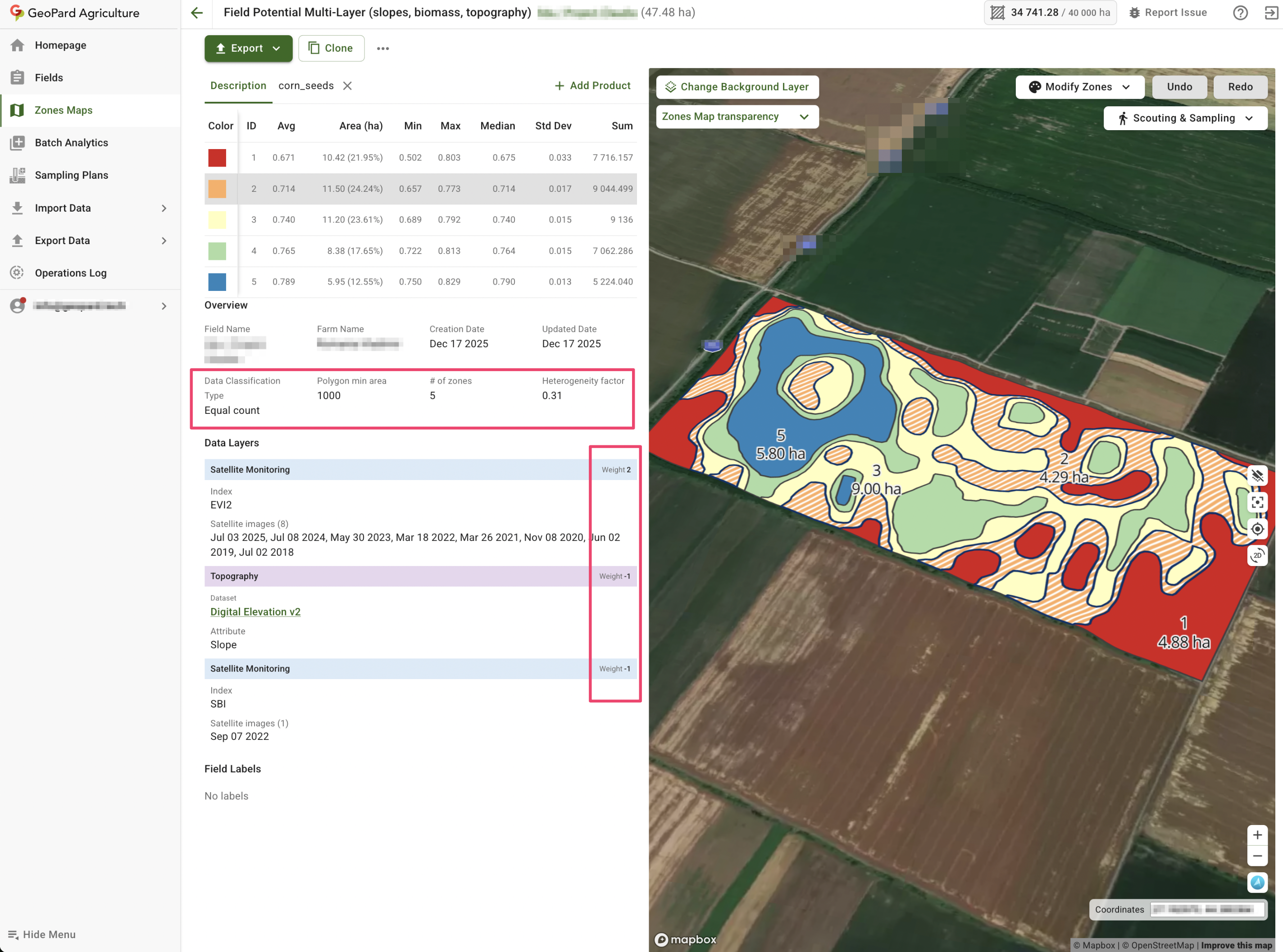
Not all parts of your field are the same. Soil zone mapping helps identify different conditions within your field. Use GeoPard’s satellite imagery and topography analytics to create detailed maps. These maps highlight areas of high and low productivity.

Understanding field variability lets you apply the right amount of seed and nutrients where needed. This targeted approach not only boosts crop potential but also cuts costs. By focusing on specific zones, you maximize efficiency and increase your return on investment.

Optimizing VRA Seeding and Nitrogen Management

Once your field is ready, it’s time to optimize seeding and nitrogen management. Let’s dive into creating effective management zones.

Building Effective Management Zones

Creating management zones is crucial for efficient resource use. Begin by analyzing historical yield data and current soil conditions. GeoPard’s software offers insights by combining these data points.

These zones guide where to focus your efforts. Zones with poor soil can receive more attention, while zones with rich soil require less intervention. This approach conserves resources and enhances productivity.

Creating VRA Seeding and Nitrogen Maps

Variable Rate Application (VRA) is a game-changer. It ensures precise distribution of seeds and nitrogen. Use GeoPard’s VRA maps to tailor applications according to management zones.

By applying the right amount of input, you prevent waste and increase crop vitality. This precision leads to higher yields and better resource management. A well-executed VRA strategy can transform your agricultural outcomes.

Leveraging John Deere Operations Center

Integrating your data with the John Deere Operations Center simplifies your workflow. This platform provides a seamless connection between your equipment and data analytics.

By leveraging this integration, you can access real-time data and make informed decisions quickly. This streamlined process saves time and enhances your overall farming strategy.

Early Crop Monitoring and Data-Driven Decisions

After planting and optimizing inputs, focus on monitoring your crop growth. Early detection of issues is key to successful farming.

Satellite Imagery NDVI and NDRE Insights

Satellite imagery provides an aerial view of crop health. NDVI and NDRE indices are valuable tools for monitoring plant vigor and nutrient status. Regularly reviewing these indices helps spot problems before they escalate.

Healthy crops reflect in a more vibrant NDVI, signaling optimal growth conditions. If NDRE readings indicate nutrient deficiencies, you can address them promptly. This proactive monitoring ensures your crops stay on track.

Topography Analytics and Yield Data Analysis

Understanding your field’s topography is essential for managing water flow and erosion. GeoPard’s topography analytics offer detailed insights. By analyzing these, you can implement measures to manage water efficiently.

Yield data analysis helps track progress and plan for future seasons. Evaluating past yields combined with current data helps refine your strategies. This continuous improvement cycle enhances productivity year after year.

In-Season Scouting and Agronomic Support

Field scouting is vital for ongoing crop health. Regularly walk your fields to identify potential issues like pests or diseases. Use GeoPard’s agronomic support tools to log observations and take corrective actions.

In-season scouting allows you to react swiftly to challenges. Collaborate with agronomists when needed, ensuring your crops receive expert care. Staying vigilant helps secure a bountiful harvest.

In conclusion, embracing precision tools and data-driven strategies can significantly enhance your spring crop management. By preparing thoroughly and leveraging advanced technology, you set the stage for success.

Reflect on the quarter’s precision ag insights and prepare to adopt smarter strategies.

From Q1 Insights to Spring Wins: Turning Early-Season Data Into Precise Actions

From Q1 Insights to Spring Wins: Turning Early-Season Data Into Precise Actions

You spent months gathering Q1 agronomy insights, but how do you turn that data into spring planting strategy that actually drives results? Many consultants and growers struggle to move from raw numbers to clear, actionable steps. In this post, you’ll learn how to build stable management zones, generate precise VRA prescriptions, and connect your equipment data for smarter spring operations with GeoPard’s agronomic analytics platform.
Harnessing Q1 Agronomy Insights

Unlocking the potential of Q1 agronomy insights can set the foundation for a successful planting season. The goal is to transform data into actionable strategies that maximize yield and efficiency.

Building Stable Management Zones

Stable management zones are key to tailored agronomic practices. First, gather multi-year satellite imagery and soil data. This helps identify areas of consistent performance across your fields. Use this data to draw boundaries that reflect the unique characteristics of each zone. This personalized approach allows you to apply precise inputs where they are needed most.

Crafting VRA Prescriptions

Variable Rate Application (VRA) prescriptions can significantly boost productivity. Start by analyzing yield data and topography. With these insights, generate maps that guide seed, fertilizer, and pesticide applications. VRA prescriptions ensure resources are allocated efficiently, reducing waste and increasing returns.

Synchronizing Equipment Data

Connecting your equipment with data analytics platforms like GeoPard is essential. By syncing machinery data with agronomic insights, you can automate applications and monitor performance in real-time. This seamless integration supports informed decision-making and enhances operational efficiency.

Optimizing Spring Planting Strategy

With your zones and prescriptions in place, it’s time to focus on optimizing your planting strategy. This involves precise monitoring and targeted applications based on real-time data.

Monitoring Crop Vigor with Satellite NDVI

Satellite NDVI is a powerful tool for tracking crop health. Regularly monitor NDVI images to assess crop vigor and identify stress areas early. This proactive approach allows timely interventions, ensuring optimal growth conditions.

Implementing Variable Rate Seeding

Variable rate seeding optimizes plant populations by adjusting seed rates according to zone productivity. Use soil and historical yield data to determine the best seeding rates for each area. This ensures plants have the resources they need to thrive, leading to higher yields.

Planning Nitrogen Topdress Applications

Nitrogen is crucial for crop development, but over-application can be costly and harmful. Plan your topdress applications using soil test integration and real-time crop monitoring. Adjust nitrogen rates based on current crop needs and environmental conditions to maximize efficiency and minimize waste.

Tracking and Analyzing ROI

After implementing your strategies, it’s crucial to track their effectiveness and analyze the return on investment. This informs future planning and optimizes resource allocation.

As-Applied Data Analysis

Analyzing as-applied data provides insights into application accuracy and effectiveness. Compare planned vs. actual application rates to identify discrepancies. This analysis helps fine-tune future applications for better results.

Zone Stability and Field Variability Mapping

Mapping field variability and zone stability highlights areas needing attention. Use this information to adjust management practices and improve overall field performance. Regular mapping keeps your strategy aligned with field dynamics.

Setting Up ROI Analysis in Agriculture

ROI analysis is essential for evaluating the success of your agronomic strategies. Calculate inputs vs. outputs to determine profitability. This analysis helps refine future strategies and ensures a focus on high-return practices.

By systematically applying these insights, you can transform raw Q1 data into actionable strategies that drive success throughout the growing season. With GeoPard’s platform, unlocking the full potential of your fields is within reach.

Reflect on the quarter’s precision ag insights and prepare to adopt smarter strategies.

How Advanced Analytics Helped Agribusinesses Overcome Q1 Hurdles: A Strategic Guide

How Advanced Analytics Helped Agribusinesses Overcome Q1 Hurdles: A Strategic Guide

Q1 throws a mix of weather swings, tight planting timelines, and rising input costs at agribusinesses every year. You’ve likely felt the pressure of these challenges cutting into your margins and decision-making. With advanced analytics for agribusiness, you can turn complex data into clear, actionable steps—like creating precise management zones and variable rate application maps—that keep your operations on track. Let’s explore how GeoPard’s AI-driven platform helped farms overcome these hurdles and deliver measurable ROI this season. For more insights, check out this document.

Navigating Q1 Agribusiness Challenges

Weather, prices, and planting windows create a perfect storm in Q1 for agribusinesses. Let’s see how you can navigate these challenges effectively.

Managing Weather Volatility with Precision

Weather unpredictability is a major concern for farmers. But what if you could forecast accurately and prepare better? GeoPard’s platform helps you use historical data and satellite imagery to understand weather patterns. This data lets you plan operations when conditions are just right.

For instance, using NDVI time series, you can track plant health and predict growth stages. This means you can optimize your crop management around expected weather changes, ensuring your crops thrive regardless of what Mother Nature throws your way.

Tackling Input Price Fluctuations

Why pay more when you can save smartly? Rising input costs can eat into profits, but smart planning makes a difference. GeoPard’s software analyzes your field data to recommend precise input levels. This means you use only what you need, cutting unnecessary costs.

Imagine reducing fertilizer use by 20% while maintaining yield. By understanding yield and soil data integration, you’re not just guessing; you’re making data-backed decisions that result in savings.

Addressing Tight Planting Windows

Timing is everything in planting. Miss the window, and yields suffer. GeoPard’s crop monitoring platform keeps you informed about optimal planting times. With real-time data, you can seize the perfect moment.

Think of it this way: instead of rushing, you’re strategizing. Precise timing means healthier crops and better yields, putting you ahead in Q1.

Leveraging Precision Agriculture Software

Precision agriculture software transforms farming challenges into opportunities. Here’s how GeoPard leads the way with its advanced tools.

GeoPard for Advanced Analytics

Why settle for guesswork when you can have precision? GeoPard offers advanced analytics for agribusiness, turning complex data into clear solutions. With over 20 years of satellite imagery, you gain a historical edge in planning.

This software doesn’t just provide data; it offers insights. By integrating topography analytics, you understand your land better, making informed decisions that boost productivity.

Smart Agronomic Recommendations

What if your software could think like an agronomist? GeoPard offers smart agronomic recommendations based on real-time data. The recommendations adapt to your specific fields, ensuring optimal input use and timing.

This means you’re not just managing your fields; you’re mastering them. With precise recommendations, you enhance productivity and reduce waste.

Creating Management Zones and VRA Maps

Imagine knowing exactly where to plant, fertilize, or irrigate. GeoPard’s tools allow you to create management zones and variable rate application maps tailored to your fields. These maps ensure every input is used effectively.

Instead of a one-size-fits-all approach, you have a customized strategy that reflects your unique landscape, leading to better resource management and higher yields.

Realizing ROI with Data-Driven Agronomy

Data is power, especially in agriculture. Let’s explore how you turn data into profit with GeoPard.

Crop Monitoring and Decision Support

Picture having a personal assistant for your fields. GeoPard’s crop monitoring platform offers in-season decision support, keeping you updated on crop health and growth. This proactive monitoring means fewer surprises and more informed decisions.

By spotting issues early, you save on potential losses, turning challenges into opportunities for improvement.

Integrating Yield and Soil Data

Your soil tells a story. By integrating yield and soil data, you understand your fields better. GeoPard’s platform helps you combine these data points to enhance decision-making, ensuring every action is guided by facts.

This integration means better planning, optimized input use, and ultimately, higher returns on your investment.

John Deere Operations Center Bi-Directional Sync

In the fast-paced world of farming, flexibility is key. GeoPard’s integration with John Deere Operations Center provides bi-directional data sync, ensuring your data flows smoothly between platforms. This seamless integration means your operations are always up-to-date.

By syncing data, you streamline processes, reduce errors, and enhance efficiency, leading to a higher ROI. This approach not only saves time but also positions you for success in agribusiness.

Prepare for smarter farm decisions this year

Q1 Precision Ag Playbook: Common Challenges and AI Solutions for Consultants and Farm Managers

Q1 Precision Ag Playbook: Common Challenges and AI Solutions for Consultants and Farm Managers

Q1 farm planning often feels like racing against the clock. You juggle messy data, uncertain management zones, and input decisions that can make or break the season. This playbook breaks down common hurdles and shows how AI agronomy analytics can streamline your workflow, turning confusion into clear, actionable steps. Get ready to sharpen your edge with tools designed for consultants and farm managers aiming for smarter, faster results.

Tackling Q1 Precision Ag Challenges

Facing Q1 challenges can be daunting, but the right strategies make all the difference. Let’s explore practical solutions.

Overcoming Data Cleanup Issues

Messy data can lead to costly mistakes. You need clean, precise data for effective planning. Start by assessing your data sources. Are they reliable? Often, data from different sources doesn’t match up. This can cause confusion. Regular audits of your data can help spot inconsistencies early. Use software tools to automate these checks, saving you time and reducing errors. GeoPard’s platform offers built-in data cleanup features, ensuring your data is ready for action.

Once your data is clean, integration becomes key. Seamlessly connecting data from various sources, like yield maps and soil tests, can improve your insights. This integration allows for a more comprehensive view of your fields, helping you make informed decisions. The longer you put off organizing your data, the more difficult the season becomes. Tackling this now sets you up for success.

Validating Management Zones

Management zones are crucial for precision farming. They help you apply the right inputs at the right time. But how can you be sure they’re accurate? Start by reviewing your historical data. Are there patterns that suggest a need for adjustment? Field observations are also vital. What do you see that data might miss?

Once you’ve gathered your insights, use advanced tools to refine your zones. GeoPard offers capabilities to create detailed management zones with precision. By using satellite imagery and historical data, you can ensure your zones reflect the true conditions of your fields. Most people think their zones are perfect, but revisiting them can reveal hidden opportunities for improvement.

Leveraging AI for Input Planning

With your data sorted and zones validated, it’s time to plan inputs strategically. AI can offer significant advantages here.

Creating Variable Rate Application Maps

Variable rate application (VRA) maps help you distribute inputs efficiently. Start by defining the needs of each field. Consider soil type, crop requirements, and historical yield data. Using these factors, you can create a VRA map tailored to each field’s needs. This ensures that each area gets the right amount of inputs, reducing waste and boosting yields.

Don’t just rely on traditional methods. Implement AI tools like GeoPard to automate the process. AI analyzes vast amounts of data quickly, providing precise recommendations. This not only saves time but also reduces human error. The key insight here is that embracing AI isn’t just about technology; it’s about optimizing your entire operation for better results.

Enhancing Soil Sampling Strategies

Soil health is the backbone of successful farming. Regular sampling is crucial, but how do you ensure it’s done right? Start with a clear sampling plan. Identify zones based on soil type and historical performance. Sampling should be consistent and cover all critical areas.

Technology can elevate this process. GeoPard’s platform offers tools to create detailed sampling plans, ensuring comprehensive soil health insights. With AI, you can predict how changes in soil conditions might affect future crops. This allows you to proactively adjust your strategies, safeguarding your yields. Remember, the longer you wait to adjust, the more challenging the season ahead becomes.

Early-Season Risk Management Techniques

Planning is one thing; managing risks is another. Early interventions can prevent bigger problems later.

Utilizing NDVI Satellite Imagery

NDVI imagery is a powerful tool in your risk management toolkit. It offers real-time insights into crop health. By analyzing these images, you can spot issues like pest infestations or nutrient deficiencies early. This allows for timely interventions, protecting your crops and yields.

The beauty of NDVI is its ability to cover large areas quickly. No need for constant field visits. You can monitor your fields from anywhere, focusing your resources where they’re needed most. The common belief might be that on-site inspection is best, but satellite imagery offers broader, more consistent coverage.

Implementing Field Benchmarking

Field benchmarking allows you to compare performance year-over-year. This helps identify trends and make data-driven adjustments. Start by setting benchmarks based on past performance. Consider factors like yield, input use, and soil health. Regularly compare these benchmarks against current data to identify areas for improvement.

GeoPard’s tools make benchmarking straightforward. By integrating all your data, you can easily track performance and make informed decisions. The key takeaway is that benchmarking isn’t just about comparison; it’s about continuous improvement. Use these insights to refine your strategies and enhance your overall farming success.

Prepare for smarter farm decisions this year

Turn Q1 Field Data Into Action: A Step-by-Step Guide to Smarter Agronomic Decisions

Turn Q1 Field Data Into Action: A Step-by-Step Guide to Smarter Agronomic Decisions

Q1 data analytics can reveal hidden patterns in your fields that too often go unnoticed. You’ve already collected yield maps, soil sampling data, and satellite imagery—now it’s time to turn all that into actionable agronomic decision-making. This guide shows you how to refresh management zones, build precise VRA prescriptions, and plan in-season strategies using GeoPard’s AI-powered analytics, so you can make smarter, data-backed choices all season long. For more insights, check this link.

Leveraging Q1 Data Analytics

Precision agriculture software by GeoPard

 Precision agriculture software by GeoPard

Digging into Q1 data can feel overwhelming, but it holds the key to smarter farming. As you sift through the numbers, clearer pictures of your fields emerge.

Refreshing Management Zones

Start by refining your management zones. This allows you to target specific areas with the right inputs. Use yield maps and soil data to identify zones. With tools like GeoPard, you can create dynamic maps that reflect the real-time needs of your land. This approach not only saves time but also boosts productivity.

For example, a farmer noticed low yields in a specific zone. By analyzing Q1 data, he adjusted his inputs, leading to a 15% increase in production the following season. The takeaway? Refreshing zones isn’t just a task—it’s a game-changer.

Building VRA Prescriptions

Next, focus on creating VRA prescriptions. Variable Rate Application means applying the right amount of inputs at the right time. It’s precision at its finest. To build effective VRA maps, combine data from yield maps, soil tests, and historical imagery. This lets you fine-tune input levels across different areas.

Imagine you’re planting corn. Instead of a blanket approach, VRA allows you to apply more fertilizer where the soil needs it and less where it doesn’t. This precision can lead to reduced waste and improved crop health.

Planning In-Season Strategies

Finally, plan your in-season strategies with confidence. GeoPard’s analytics provide insights for every growth stage. Use this data to decide when to irrigate, fertilize, or apply pesticides. Adjust your approach based on real-time field conditions.

Consider the impact: a 10% increase in efficiency by simply timing your actions better. Planning isn’t about guessing; it’s about informed decisions that lead to better yields.

Tools for Agronomic Decision-Making

Understanding the tools at your disposal is crucial. They transform raw data into actionable insights, helping you make informed decisions every step of the way.

AI-Powered Analytics Benefits

AI-powered analytics can revolutionize how you approach farming. These tools process complex datasets quickly, revealing patterns you might miss. They help predict outcomes and suggest the best actions to take.

Think about it: most people believe intuition is enough, but data-driven insights are the future. Embrace this technology to stay ahead in the game. The longer you wait, the more opportunities you might miss.

Integrating John Deere Operations Center

Integrating systems like the John Deere Operations Center makes managing your data seamless. This platform syncs with GeoPard, allowing for smooth data flow. It’s like having all your tools in one toolbox, ready for action.

For instance, you can easily transfer data between your machines and software, saving time and reducing errors. Integration not only simplifies operations but also enhances data accuracy, leading to better decision-making.

Utilizing Yield and Soil Data

Yield and soil data are foundational to effective management. By utilizing them, you get a clear picture of what’s happening under the surface. Use these insights to tweak your strategies and improve outcomes.

For example, by analyzing soil data, you can adjust nutrient applications, ensuring your crops get what they need to thrive. It’s all about making data work for you.

Optimizing Crop Management Practices

With data in hand, it’s time to refine your crop management practices. These strategies ensure your fields reach their full potential.

Monitoring with Satellite Imagery

Satellite imagery offers a bird’s-eye view of your fields, revealing patterns invisible from the ground. Regular monitoring helps spot issues like pest infestations or water stress early, allowing timely interventions.

Consider using NDVI and biomass indices. These metrics provide insights into crop health and vigor, guiding your management decisions. With images updated every few days, you’ll always have the latest data at your fingertips.

Nitrogen and Seeding Rate Strategies

Optimizing nitrogen and seeding rates is vital for maximizing yields. By analyzing data, you can tailor these rates to specific field conditions, ensuring optimal growth.

For example, a farmer adjusted seeding rates based on soil fertility, resulting in a balanced crop stand and improved yields. It’s not about applying more; it’s about applying smartly.

Conducting ROI Analysis in Agriculture

Finally, conduct regular ROI analysis to ensure your practices are cost-effective. Use tools to evaluate the financial impact of your decisions, helping you allocate resources wisely.

For instance, you might discover that a small change in practice leads to significant cost savings. ROI analysis isn’t just about profit; it’s about making your operations sustainable and efficient.

With these insights and tools, you’re equipped to transform your farming practices. Use data as your guide, and watch your productivity soar. For more detailed studies, you can refer to this resource.

Reflect on the quarter’s precision ag insights and prepare to adopt smarter strategies.

Streamlining Farm Data Workflows: Q1 insights and actionable tips for ag service providers

Streamlining Farm Data Workflows: Q1 Insights and Actionable Tips for Ag Service Providers

You just spent hours juggling fragmented data across multiple platforms and still can’t get a clear picture of your fields. Farm data workflows often slow down agronomists and service providers more than they realize. In this post, you’ll find Q1 insights revealing common bottlenecks and practical tips to streamline your data ingestion, analysis, and delivery using GeoPard’s precision agriculture software. Learn more here.

Key Q1 Farm Data Insights

Understanding Q1 farm data insights can illuminate significant challenges and solutions for agronomists. Let’s explore common workflow issues and how GeoPard makes a difference.

Common Data Workflow Bottlenecks

Agricultural data often sits in silos, leading to delays. Imagine trying to merge data from multiple sources manually. This can take hours. Many service providers report that over 50% of their time gets lost in data wrangling. The complexity of handling different formats is another hurdle. Most people think that having large amounts of data is beneficial, but it can overwhelm if not managed well.

GeoPard’s Role in Streamlining

GeoPard’s software simplifies these workflows, making data more accessible. By consolidating information from various sources, it reduces processing time significantly. With GeoPard, you can integrate and analyze data in real-time. This approach challenges the belief that data management has to be cumbersome. Instead, it’s about efficiency and clarity.

Streamlining Data Processes

Improving how you handle farm data can transform your agricultural operations. Let’s see how you can optimize each stage, from ingestion to delivery.

Ingesting Agricultural Data Efficiently

The first step is gathering data effectively. GeoPard supports multiple data types, including soil sensors and satellite imagery. This integration enables a seamless collection process. For instance, using automated data entry, you can reduce errors and save time. Many think manual entry is unavoidable, but automation proves otherwise.

Analyzing with Precision Agriculture Software

Once you’ve collected data, analysis becomes crucial. GeoPard’s precision software uses AI to provide deep insights. You can generate management zones and variable rate application maps. This means you can make informed decisions faster. A key insight: precise data analysis leads to better crop management.

Delivering Insights to Ag Service Providers

Finally, delivering insights efficiently is vital. GeoPard ensures that service providers receive timely reports. This includes yield data analysis and topography analytics. By sharing clear insights, you help clients optimize their operations. The longer you wait to streamline, the more opportunities you miss.

Actionable Tips for Service Providers

Enhance your service offerings with practical steps. These tips will help you harness GeoPard’s capabilities effectively.

Implementing a Practical Checklist

Creating a checklist can guide your workflow improvements. Start with assessing your current data sources. Then, identify integration opportunities with platforms like GeoPard. Regularly reviewing this checklist ensures continuous improvement. Here’s the key insight: structured processes lead to better outcomes.

Engaging with GeoPard’s Free Trial

Trying out GeoPard’s trial can demonstrate its potential. During the trial, explore features like AI agronomy analytics and field analytics platforms. This hands-on experience can show you how it fits into your workflow. Most people hesitate to try new software, but trials offer risk-free exploration.

Integration with John Deere Operations Center

GeoPard integrates seamlessly with systems like the John Deere Operations Center. This bi-directional data sync enhances collaboration. By using such integrations, you can streamline operations further. It challenges the idea that systems must remain isolated. Instead, interconnected platforms offer greater value.

In conclusion, streamlining your farm data workflows with GeoPard can lead to significant operational improvements. From ingestion to delivery, each step offers opportunities for optimization. Adopting these practices will not only improve efficiency but also enhance your service offerings.

Prepare for smarter farm decisions this year

The Economic Impact of Skipping Precision Insights

The Economic Impact of Skipping Precision Insights

Skipping precision agriculture software is costing you more than you realize. Wasted inputs, unpredictable yields, and overlooked management zones chip away at your profit per acre every season. GeoPard’s farm analytics platform brings all your data together—soil, satellite imagery agriculture, topography analytics—to help you spot inefficiencies and boost agronomic ROI. Keep reading to see how integrating these insights with tools like John Deere Operations Center integration can turn losses into gains. Learn more here.

Ignoring Precision Agriculture Insights

Precision agriculture isn’t just a buzzword; it’s a lifeline for boosting farm profits. Ignoring these insights can lead to significant economic setbacks.

Economic Consequences of Waste

When you don’t use precise data, you waste valuable resources. Many farmers overuse fertilizers and water, thinking more is better. But without precision tools, you might be pouring money down the drain. A recent study showed that farmers could cut input costs by 15% using precision methods. This waste not only affects your pocket but also the environment. See the impact.

Farmers often believe that traditional methods are more reliable. However, without precision software, predicting exact needs becomes guesswork. This leads to over-application, inflating costs unnecessarily. Consider this: a farmer using standard practices might apply 10% more fertilizer than needed, directly impacting profits.

Yield Loss from Data Neglect

Ignoring data means risking lower yields. Without insights, you can’t optimize your fields for maximum output. A farm using GeoPard’s platform saw a 20% increase in yield after integrating topography analytics. Data neglect can lead to missing out on such potential gains.

Farmers who bypass data may also face unexpected crop failures. With precision tools, you can monitor crop health and spot issues early, avoiding drastic losses. Imagine catching a disease outbreak before it spreads, simply by using a crop monitoring tool.

Inefficiencies in Farm Operations

Operational inefficiency is a silent profit killer. Without precision insights, farm operations can become chaotic. You might spend more time and resources fixing problems that could have been prevented. The GeoPard platform helps streamline these processes, making operations smoother and less costly.

A lack of precise management zones often results in uneven growth across fields. This inconsistency can reduce overall yield quality and quantity. By using precision agriculture software, you ensure every part of your field is optimized for growth, reducing waste and increasing profit per acre.

Recovering Lost Profit Per Acre

Now that we’ve seen what ignoring precision insights costs, let’s explore how to recover those lost profits. GeoPard offers the tools you need to make every acre count.

GeoPard’s Analytics Overview

GeoPard’s analytics platform gives you clear, actionable insights. By analyzing data from soil, satellite imagery, and topography, you can make informed decisions. This data-driven approach helps you target problem areas and improve overall efficiency. For instance, using GeoPard, a farm increased its agronomic ROI significantly by identifying and correcting inefficiencies.

With over 20 years of satellite imagery, GeoPard provides historical context to your decisions. This wealth of information allows you to predict trends and prepare accordingly. Imagine having the power to foresee what your fields need and when.

Integrating with John Deere Operations Center

GeoPard seamlessly integrates with John Deere Operations Center. This integration means you can synchronize data between platforms, enhancing your operational efficiency. By combining GeoPard’s insights with John Deere’s tools, you can create a powerhouse of precision farming.

The integration allows for easy transfer of data, ensuring that you never miss a beat. This bi-directional flow of information lets you make real-time adjustments, optimizing every aspect of your farm operations. Explore integration benefits here.

Maximizing ROI with Precision Tools

Precision tools are your best bet for maximizing ROI. GeoPard provides versatile options for creating management zones and variable rate application maps. With these tools, you apply the right amount of inputs exactly where needed, reducing waste and improving yields.

Farmers using precision tools report higher profitability and smoother operations. By leveraging GeoPard’s advanced analytics, you can make data-driven decisions that ensure every dollar spent contributes to your bottom line. The longer you wait, the more opportunities slip away; act now to secure your farm’s future profitability.

In summary, skipping precision agriculture insights is a costly mistake. But with GeoPard, you have the power to turn the tide, reclaiming lost profits and ensuring your farm’s success in the data-driven age of agriculture.

Understand what happens when critical farm data goes unused.

Plan, Apply, Analyze: GeoPard Use Cases for VRA and Post Season ROI

Plan, Apply, Analyze: GeoPard Use Cases for VRA and Post Season ROI

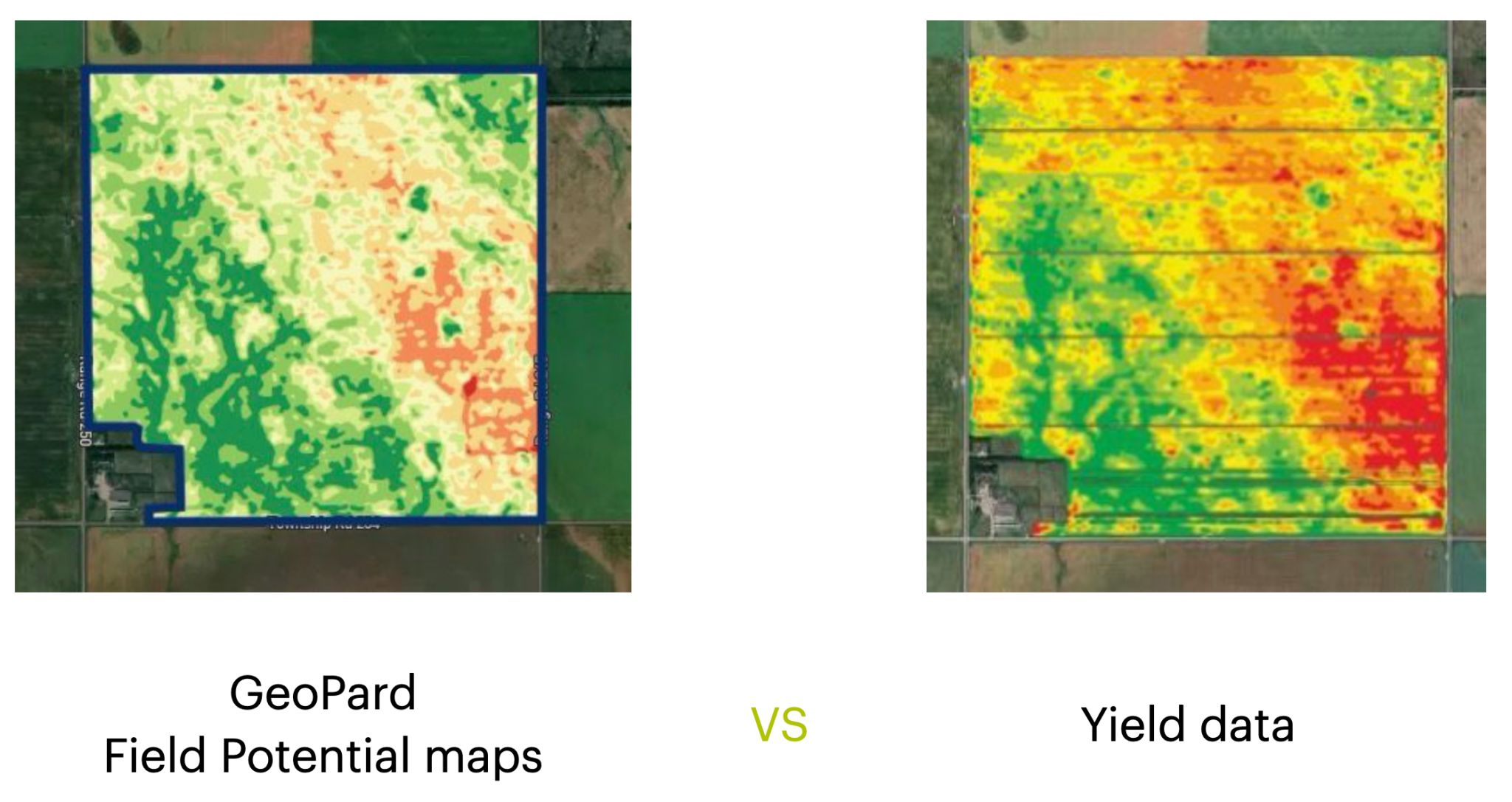
Most precision agriculture tools stop short when it comes to linking pre-season planning with post-season results. You need a platform that ties your management zones and VRA maps directly to yield and ROI analysis. GeoPard Agriculture does exactly that—combining soil, satellite, and machinery data so you can plan smarter, apply precisely, and measure returns with confidence. Let’s explore workflows that put your data to work all season long. For more insights, visit our field potential and yield data analysis page.

GeoPard for Agronomic Planning

GeoPard Field Potential maps vs Yield data

GeoPard Field Potential is your start into Precision Agriculture

Stepping into the world of agronomic planning, GeoPard offers more than just data. It turns your field insights into actionable strategies.

Crafting Management Zones

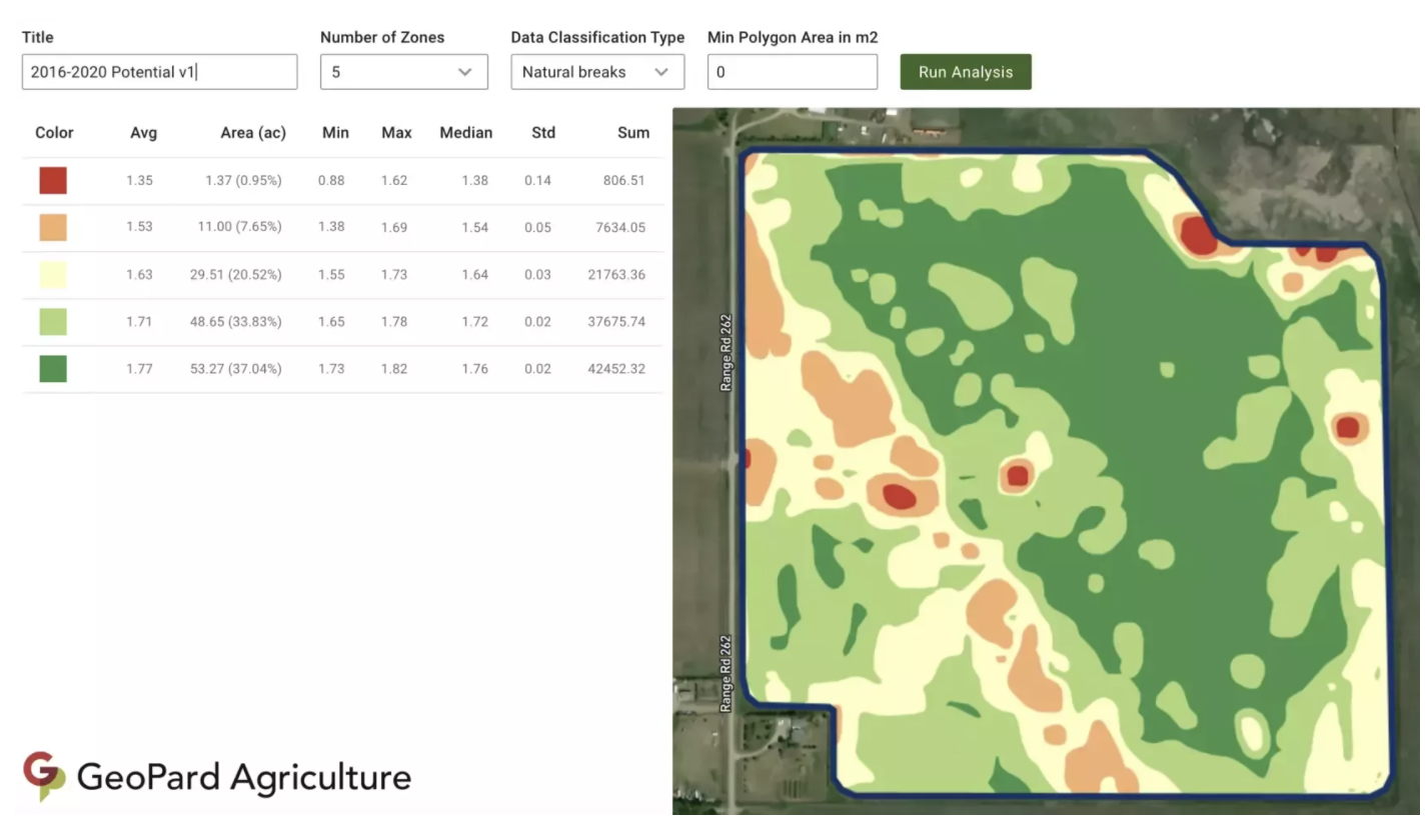
Creating management zones is crucial. With GeoPard, you can use varied data layers to draw precise zones. This means you can focus your resources exactly where they’re needed. For example, using soil type and crop health data, you’ll know precisely where to increase or reduce inputs. This way, not only do you save costs, but you also boost productivity.

Imagine a farmer using satellite and soil data to craft zones. They notice a patch needing more nutrients. With GeoPard, they adjust their plan, apply the right amount, and watch the crops thrive. This precise application is how you turn data into yield. Want to learn more about creating management zones? Check out our detailed guide.

Precision Agriculture Software Tools

GeoPard’s tools offer more than just data aggregation. They provide a comprehensive look at your farm’s health. From satellite images to soil tests, you have everything at your fingertips. These tools help you plan efficiently, ensuring every seed, drop of water, and ounce of fertilizer is used wisely.

Consider the impact: A user can reduce input wastage by up to 30%. That’s real savings and real impact on your bottom line. Plus, you’re helping the environment by minimizing runoff and over-application. Ready for the next step? Explore how these tools can revolutionize your farm management in our software tools overview.

In-Season Monitoring with GeoPard

Once your plan is in place, in-season monitoring helps ensure everything stays on track. GeoPard offers intuitive tools for real-time insights.

Leveraging NDVI Satellite Imagery

NDVI satellite imagery is a game-changer. By assessing vegetation health, you can spot issues before they become costly problems. Picture this: you notice a field section with declining NDVI values. With GeoPard, you identify a pest issue and address it promptly, saving your crop.

These images update every few days, providing fresh insights into your fields. This frequency means you’re never in the dark about what’s happening on your farm. By staying informed, you make timely decisions that can save you money and maximize yield. For more on NDVI, dive into our satellite monitoring tutorials.

Crop Monitoring with Yield Data

Monitoring doesn’t stop with satellites. Yield data offers another layer of insight. Use it to track performance and make adjustments. Imagine discovering a particular seed variety outperforms others. You can pivot your strategy to focus on what works best.

With GeoPard, you can compare yields year-on-year, identifying long-term trends and making informed decisions. This level of detail is what sets successful farms apart. Curious about maximizing yield data? Visit our analytics tutorials.

Post-Season ROI Analysis

Finally, post-season analysis ties everything together. It’s where strategy meets results, and GeoPard excels in delivering clear insights.

Examining Variable Rate Applications

Evaluating your variable rate applications (VRA) helps you understand what worked and what didn’t. GeoPard provides detailed maps and reports to review application efficiency. Did varying fertilizer rates impact yield as expected? You’ll have the data to know for sure.

This analysis is not just about learning; it’s about growing better next season. By understanding the impact of your VRA decisions, you enhance future outcomes. To see how others have benefited, check out this VRA use case.

Integrating John Deere Operations Center

GeoPard’s integration with the John Deere Operations Center offers seamless data flow. This integration means you can access all your farm data in one place, simplifying management tasks. Picture managing your operations with ease, thanks to synchronized data.

The integration supports data-driven decisions, improving efficiency and boosting your ROI. With everything connected, you’re better equipped to handle challenges and seize opportunities. Learn more about this powerful integration in our John Deere Operations Center overview.

By leveraging GeoPard’s comprehensive suite of tools, you transform your approach to farming. From planning to post-season analysis, each stage is enhanced, ensuring you get the most from your fields. Don’t wait to maximize your farm’s potential—start using GeoPard today!

Learn how precise data can reveal your farm’s hidden challenges.

wpChatIcon
wpChatIcon

    Request Free GeoPard Demo / Consultation


    By clicking the button you agree our Privacy Policy. We need it to reply to your request.

      Subscribe


      By clicking the button you agree our Privacy Policy

        Send us information


        By clicking the button you agree our Privacy Policy