World Soil Day, celebrated on December 5, brings people’s attention to the importance of soil and its sustainable management. The day aims to raise awareness about soil degradation.
It’s a serious environmental problem, caused due to the decline in soil condition. Industrialization or poor management of agricultural land worsens the condition of the soil.
The day highlights the importance of soil for all terrestrial life. Soil degradation leads to erosion, loss of organic matter and decline in soil fertility.
Why World Soil Day is so important?
Have you ever seen white crusts on soil? Yes, it is what you think. Soils can be salty. Salts are present naturally in soils and water, and they move freely through the soil.
Naturally, saline soils may support rich ecosystems, but natural processes such as droughts and human activities, especially improper irrigation, can increase how many salts are in soils, a process that is called salinization. Soil salinization breaks down our soils and reduces their ability to help our food grow.
Soil salinization and modification are major soil degradation processes threatening the ecosystem and are recognized as being among the most important problems at a global level for agricultural production, food security and sustainability in arid and semi-arid regions.
Salt-affected soils have serious impacts on soil functions, such as in the decrease in agricultural productivity, water quality, soil biodiversity, and soil erosion. Salt-affected soils have a decreased ability to act as a buffer and filter against pollutants.
Salt-affected soils reduce both the ability of crops to take up water and the availability of micronutrients. They also concentrate ions that are toxic to plants and may degrade the soil structure.
World Soil Day 2022
World Soil Day 2022 (#WorldSoilDay) and its campaign “Soils, where food begins” aims to raise awareness of the importance of maintaining healthy ecosystems and human well-being by addressing the growing challenges in soil management, fighting soil salinization, increasing soil awareness and encouraging societies to improve soil health.
A bit of history
The proposal for a global day to celebrate soil was first recommended in the year 2002 by the International Union of Soil Sciences (IUSS).
Under the framework of the Global Soil Partnership, and the leadership of the King of Thailand, the United Nations Food and Agricultural Organization (FAO) lent its support to the establishment of WSD.
The day was envisaged as a global platform to raise awareness about issues related to the management of soil resources.
In 2013, WSD was unanimously endorsed by the FAO Conference. The conference also requested the UN General Assembly (UNGA) for the official adoption of the WSD. The UNGA then designated the first World Soil Day on 5 December 2014.
Why was 5 December chosen as the date?
It was decided to mark WSD on 5 December as it was the official birthday of the late King of Thailand, H.M. King Bhumibol Adulyadej, who had officially sanctioned the event.

What GeoPard Agriculture do to protect the soil
The rational use is the best soil protection. Therefore, before creating a load on any plots of land, we analyze it and make a detailed plan for planting determined crops.
Prescription Maps creation
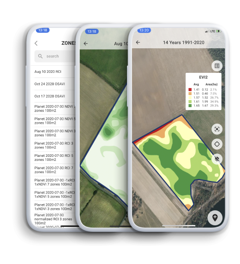
GeoPard Software helps to create Variable Rate Application (VRA) fertilizer maps by providing a platform for collecting and analyzing data from various sources, such as soil testing, crop yield, and weather data.
This information is then used to create detailed maps that show the optimal fertilizer application rates for specific areas of the field, allowing farmers to apply the right amount of fertilizer at the right time, reducing costs and increasing yields.

The software also includes tools for creating prescription maps for other inputs, such as seed, herbicides, and pesticides, providing a comprehensive solution for precision agriculture.
It also offers features for data management, record keeping, and reporting, helping farmers to stay organized and compliant with regulations. Overall, GeoPard Software helps farmers to optimize their fertilizer application and maximize their crop yields.
High-density Soil Scanners Data Analytics
Soil scanners provide a non-invasive way to analyze the physical and chemical properties of soil. By measuring factors such as pH, nutrient content, moisture levels, and organic matter, soil scanners can provide a detailed picture of soil conditions and help farmers to identify areas of the field that may require additional nutrients or other management practices.
Using soil scanners, farmers can create detailed maps of the variation in soil properties across their fields, allowing them to target their management decisions to specific areas.
For example, a farmer may discover that certain areas of the field have low pH levels, indicating that they need more lime to improve soil health. By applying lime to those specific areas, the farmer can optimize the nutrient availability for their crops and improve overall soil health.

In addition to providing valuable information about soil conditions, soil scanners can also help farmers to reduce their input costs by allowing them to apply fertilizer and other inputs only where they are needed, avoiding over-application and waste.
Overall, the use of soil scanners can help farmers to improve soil health and increase the efficiency of their management practices.
Read more about Soil Scanners Data Analytics in GeoPard
Zonal or Grid based soil sampling planning
Grid soil sampling planning is a method of collecting soil samples from a field in a systematic, organized way. The first step in this process is to create a GeoPard Field Potential Map, which shows the variation in soil properties across the field.
Based on this map, the farmer can identify areas of the field that have similar soil conditions and group them into zones. The next step is to determine the number of soil samples that need to be collected from each zone, taking into account factors such as the size of the zone and the level of precision desired.

Once the number of samples per zone has been determined, the farmer can create a grid of sampling points within each zone, using a GPS-enabled device to ensure that the samples are collected from the correct locations. The soil samples are then collected using a soil probe or other tool, and the samples are labeled and stored for analysis.
After the soil samples have been collected and analyzed, the farmer can use the results to create a detailed soil map that shows the variation in nutrient levels and other soil properties within each zone.
This information can then be used to develop a customized fertility plan for each zone, based on the specific needs of the crops and the soil conditions.
Overall, the process of grid and zonal soil sampling planning based on GeoPard Field Potential Maps allows farmers to collect and analyze soil data in a precise and organized way, providing the information needed to make informed management decisions.
Whats


