How To Calculate Fertilizer Uptake For Corn Field Based On Yield Dry Value?

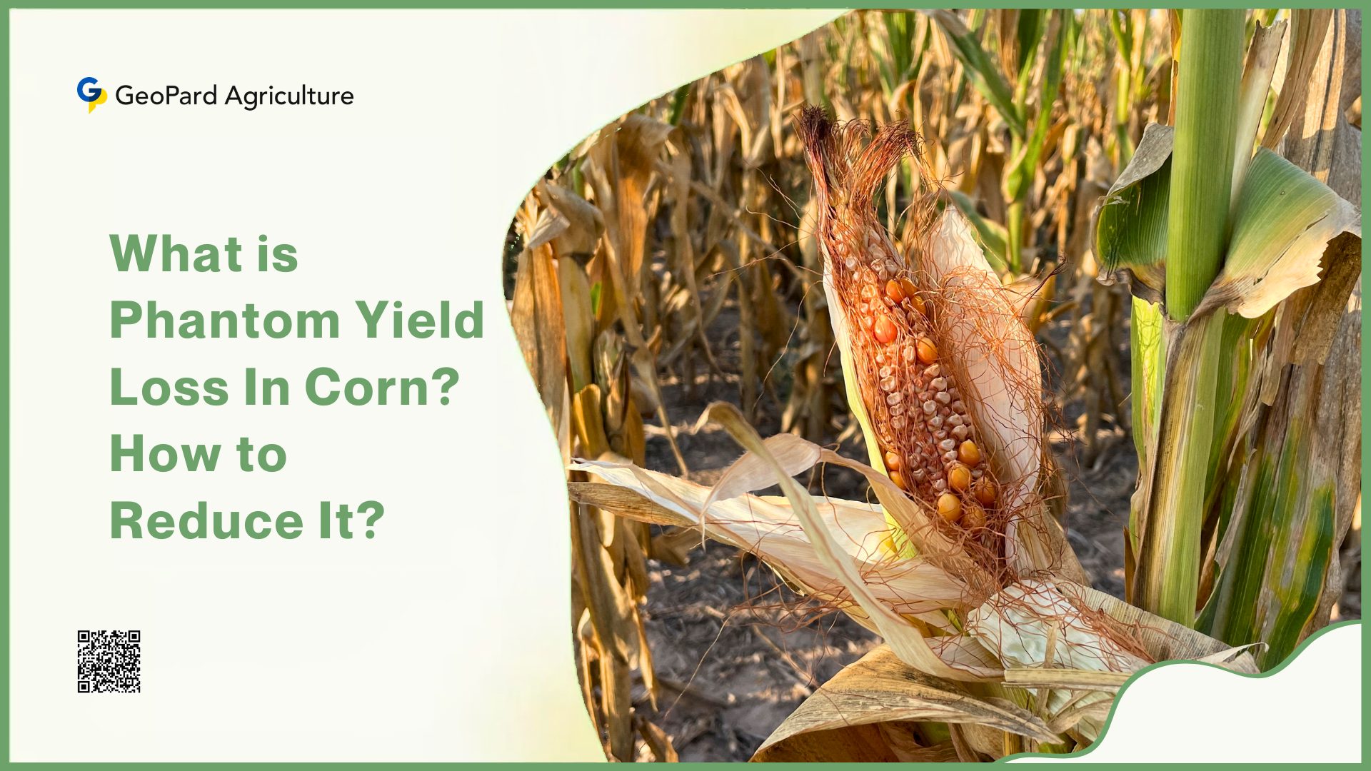
Fertilizer management is a crucial aspect of successful corn production. Properly calculating fertilizer uptake based on yield dry value ensures that crops receive the necessary nutrients to maximize yield while minimizing costs and environmental impacts.

What is Fertilizer Uptake?

Fertilizer uptake involves the absorption of nutrients by plant roots from the soil. These nutrients include macronutrients such as nitrogen (N), phosphorus (P), and potassium (K), as well as micronutrients like zinc, iron, and manganese.

Meanwhile, the efficiency of this process depends on several factors, including soil health, fertilizer type, application methods, and environmental conditions. Corn, being a high-demand crop, requires substantial amounts of nutrients to achieve its full yield potential. Efficient fertilizer uptake ensures that the corn plant receives adequate nutrition throughout its growth stages, from germination to maturity.

However, it’s important to note that excessive or improper use of fertilizers can have detrimental effects on both the crop and the environment. Over-fertilization can lead to nutrient leaching into water bodies, causing pollution and eutrophication. It can also result in nutrient imbalances in the soil, negatively impacting soil health and future crop cycles.

Why It’s So Important?

Adequate nutrient uptake promotes vigorous plant growth by ensuring that nitrogen supports leaf and stalk development, phosphorus aids in root growth and energy transfer, and potassium strengthens the plant’s resistance to disease and stress.

What is Fertilizer Uptake

Furthermore, efficient nutrient absorption directly correlates with higher yields, enabling the corn plant to produce more kernels per cob and more cobs per plant. This is particularly important for corn that is used for human consumption, as it directly affects the food’s caloric and nutritional content. Studies have shown that optimized fertilizer use can increase corn yields by 20-30%.

Moreover, nutrient availability also affects the overall quality of the corn crop. Sufficient potassium levels enhance the size and weight of the kernels, while adequate nitrogen contributes to protein content, which is vital for both animal feed and human consumption. Corn plants with access to balanced nutrients can photosynthesize more effectively, leading to better growth and higher biomass production.

What Is Corn Yield and Dry Matter Content?

Corn, a staple crop in many parts of the world, is essential for food, feed, and industrial products. Two critical aspects of corn production are yield and dry matter content. These metrics are vital for evaluating crop performance and determining the economic value of the harvest.

1. Corn Yield

Corn yield refers to the amount of harvested crop produced per unit of land area. It is a crucial metric for farmers, agronomists, and the agricultural sector as it directly correlates with the efficiency and profitability of corn production.

The typical measurement unit for corn yield in the United States is bushels per acre (bu/acre). One bushel of corn is equivalent to 56 pounds (approximately 25.4 kilograms) of shelled corn at standard moisture content (15.5%).

What Is Corn Yield and Dry Matter Content

The process of estimating corn yield is methodical and involves several components, including the number of plants per acre, ears per plant, rows per ear, kernels per row, and kernel weight. These components are measured during the growing season using the Yield Component Method, which provides a systematic approach to predict the potential harvest.

2. Dry Matter

Dry matter content in corn refers to the portion of the corn that remains after all the water content has been removed. It is a vital indicator of the quality and nutritional value of the corn, especially when used for silage. The dry matter content is significant because it affects the storage, processing, and feeding value of the corn.

For instance, research has shown that an increase in total tract starch digestibility occurs when corn silage is between 32 and 40 percent dry matter, compared to unprocessed corn silage.

The dry matter content also plays a pivotal role in the overall growth and development of the corn plant. It is involved in nutrient accumulation and partitioning, which are essential for the plant’s productivity. Understanding the dynamics of dry matter accumulation can help farmers and agronomists make informed decisions about irrigation, fertilization, and harvesting times.

How To Calculate Fertilizer Uptake For Corn Field? Step by Step Guide

Corn, one of the most widely cultivated crops, is a staple in the global food supply. To achieve optimal yields, understanding the precise fertilizer requirements based on the yield’s dry value is crucial.

By determining the nutrient requirements, farmers can apply the right amount of fertilizers. However, calculating fertilizer uptake for a corn field based on yield dry value involves understanding the nutrient removal rates by the crop.

Here is a step-by-step guide to calculating fertilizer uptake for corn fields based on yield dry value.

Step 1: Determine the Corn Yield

First, you need to know the corn yield. This is typically measured in bushels per acre (bu/acre). For dry corn, the yield is often adjusted to a standard moisture content of 15.5%.

Step 2: Convert Yield to Dry Matter

Corn grain is typically considered to be 85% dry matter. If you have the yield in bushels per acre, you can convert it to pounds of dry matter per acre.

  • Dry Matter (lb/acre) = Yield (bu/acre) × 56 lb/bu × 0.85

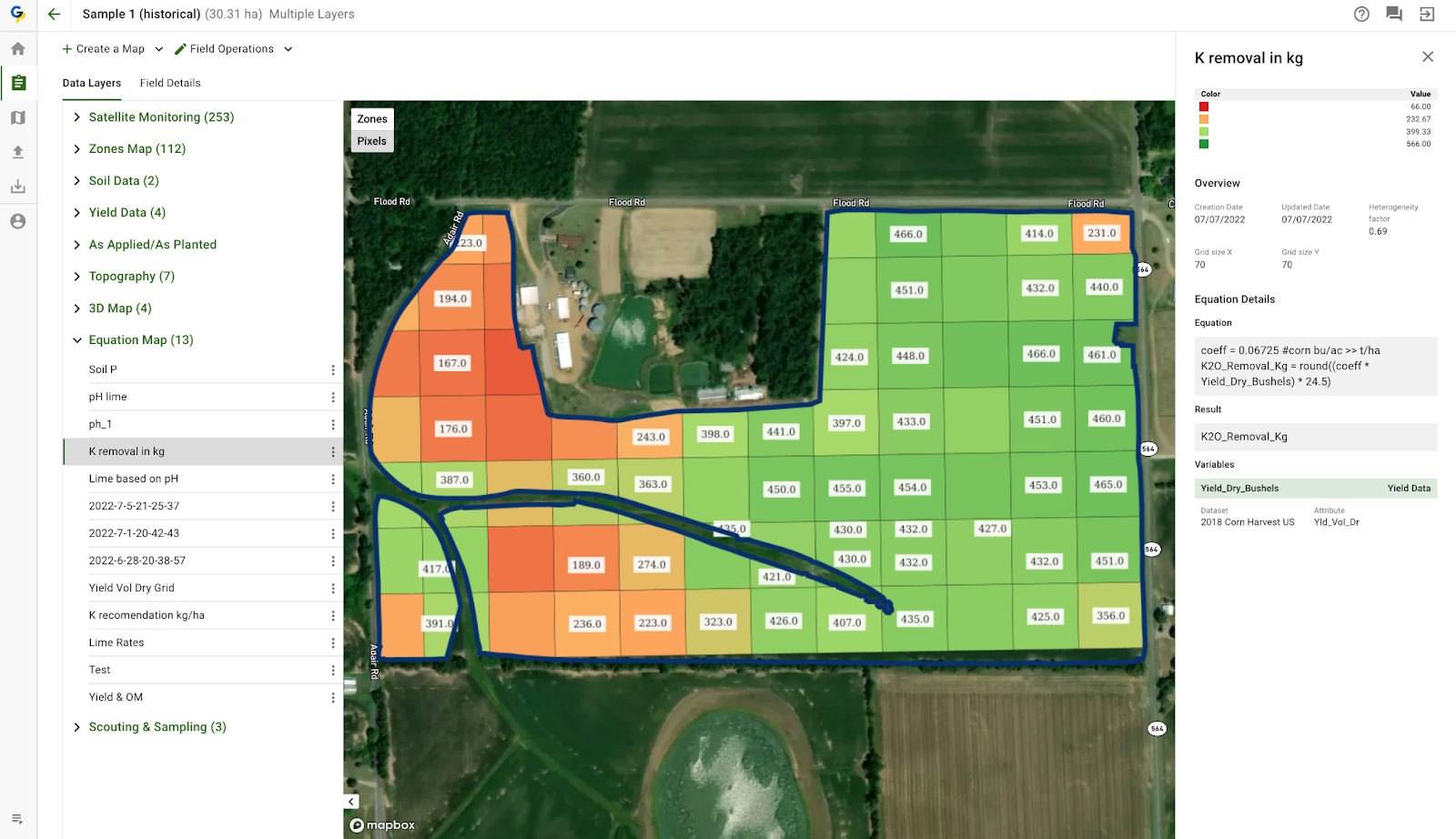
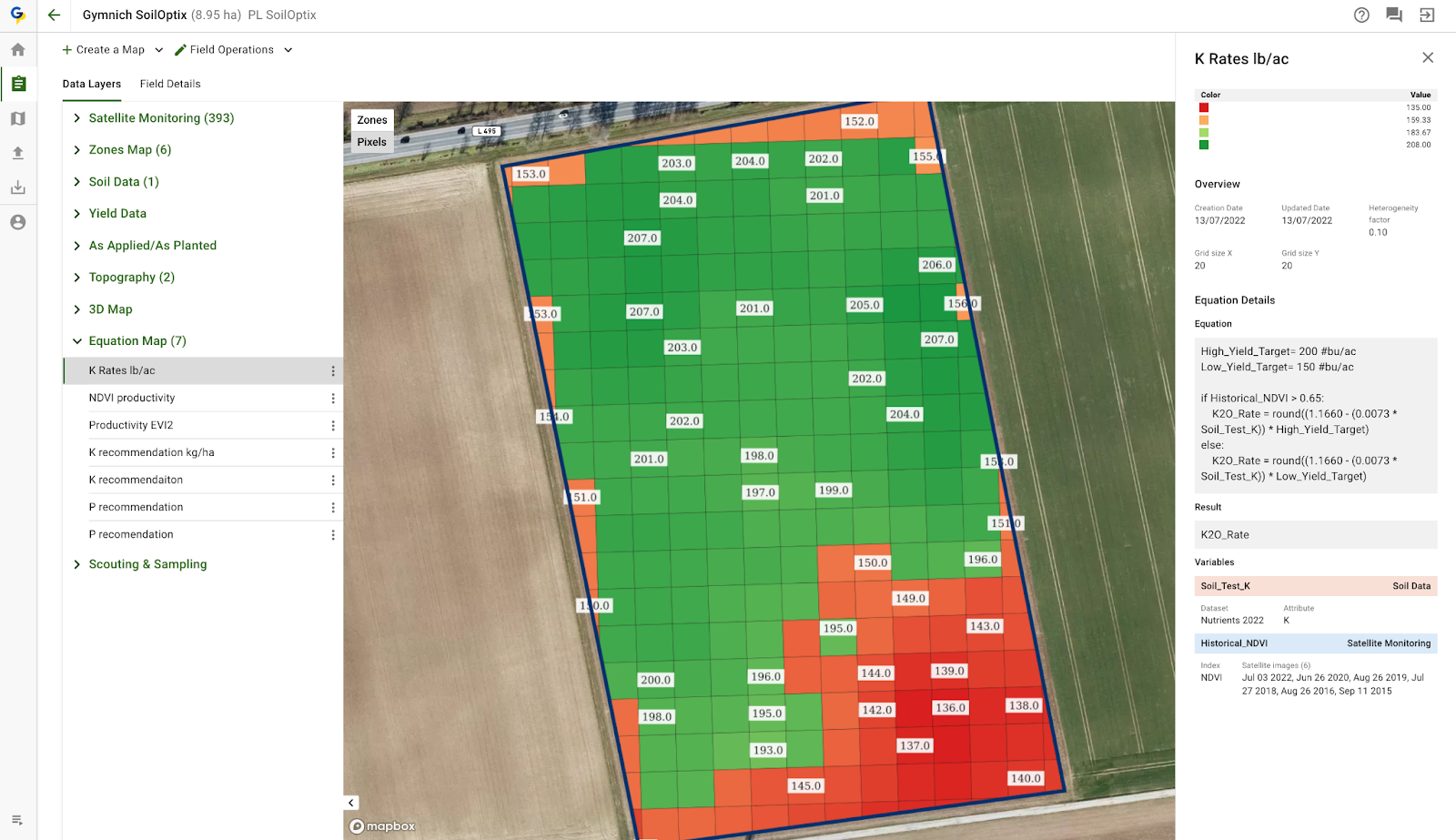
Step 3: Nutrient Removal Rates

Corn plants require essential nutrients like nitrogen (N), phosphorus (P), and potassium (K) for growth. The nutrient removal rates per unit of dry yield can be found in agronomic guidelines or research publications. Typical values are:

  • Nitrogen (N): 1.2 lbs per bushel
  • Phosphorus (P2O5): 0.44 lbs per bushel
  • Potassium (K2O): 0.29 lbs per bushel

guide to calculating fertilizer uptake for corn fields based on yield dry value

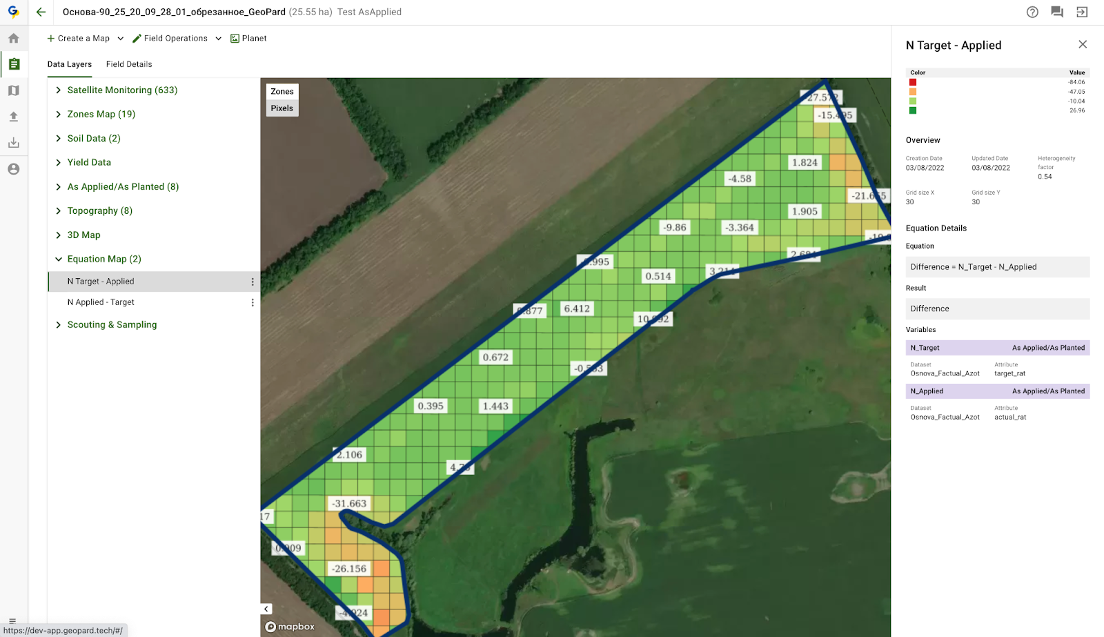
Step 4: Calculate Total Nutrient Uptake

Using the yield and the nutrient removal rates, calculate the total nutrient uptake for each nutrient.

  • Total Nitrogen Uptake (lb/acre) = Yield (bu/acre) × 1.2
  • Total Phosphorus Uptake (lb/acre) = Yield (bu/acre) × 0.44
  • Total Potassium Uptake (lb/acre) = Yield (bu/acre) × 0.29

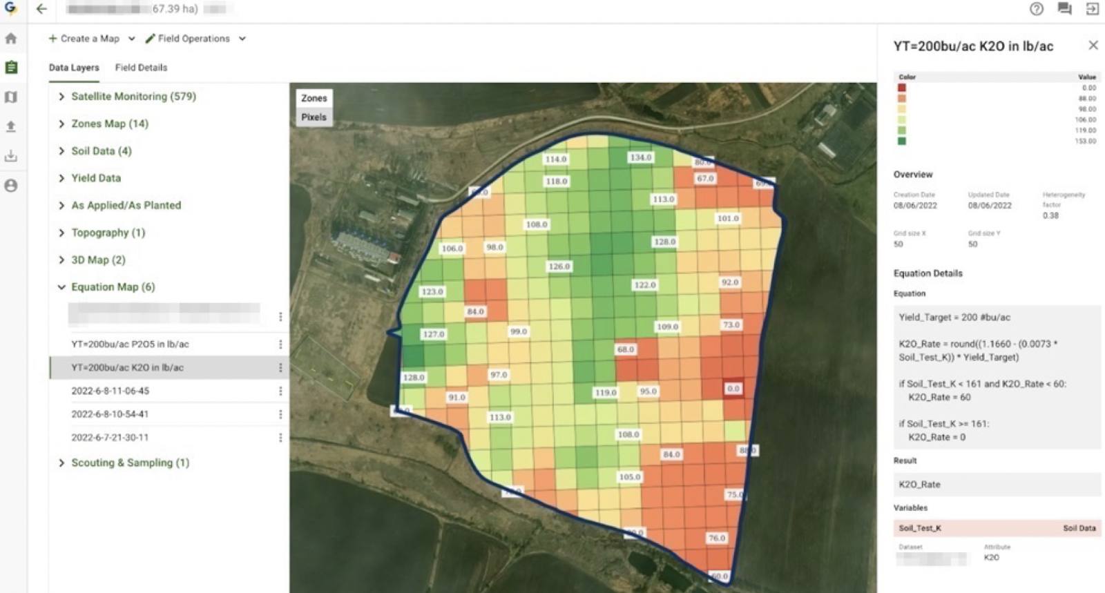
Step 5: Determine Fertilizer Requirement

Depending on the efficiency of your fertilizer application and the nutrient availability in your soil, you might need to adjust these values. Soil tests can help determine the existing nutrient levels and the appropriate fertilizer amounts.

If you assume 100% efficiency (which is rarely the case), the fertilizer requirement would be equal to the nutrient uptake. However, due to losses and other factors, you typically apply more than the calculated uptake.

Example Calculation

Let’s assume a corn yield of 200 bu/acre:

Convert Yield to Dry Matter (optional for nutrient calculations):

  • 200 bu/acre × 56 lb/bu × 0.85 = 9520 lb /acre of dry matter

Calculate Nutrient Uptake:

  • Nitrogen: 200bu/acre × 1.2 = 240 lb N/acre
  • Phosphorus: 200bu/acre × 0.44 = 88 lb P2O5/acre
  • Potassium: 200bu/acre × 0.29 = 58 lb K2O/acre

How Adjusting Fertilizer Application Improve Yield?

Based on the calculated nutrient uptake and crop response, farmers can adjust their fertilizer application rates to meet the specific needs of their crops. However, several critical factors must be considered in this process:

1. Soil Nutrient Levels

Conducting regular soil tests is essential for determining existing nutrient levels and soil health. Soil tests provide a snapshot of nutrient availability, which can inform fertilizer application rates. For instance, if soil tests reveal high phosphorus levels, farmers can reduce or eliminate phosphorus fertilizers, focusing on other nutrients the soil lacks. Key steps include:

  • Baseline Testing: Establish a baseline by conducting soil tests before planting. This helps determine the initial nutrient levels and identifies any deficiencies that need to be addressed.
  • Seasonal Testing: Perform soil tests at various stages of the growing season to monitor changes in nutrient levels and adjust fertilizer applications accordingly.

Soil Nutrient Levels Conducting regular soil tests is essential

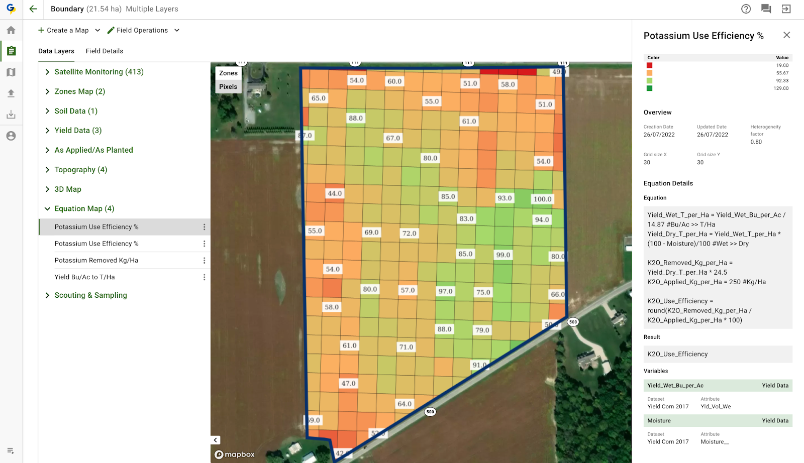
2. Fertilizer Efficiency

Not all applied fertilizer is utilized by crops; some may be lost to the environment through processes like leaching, runoff, or volatilization. To enhance fertilizer efficiency:

  • Precision Application: Utilize precision agriculture technologies, such as GPS-guided equipment and variable rate technology (VRT), to apply fertilizers more accurately and efficiently. This reduces waste and ensures nutrients are delivered where they are needed most.
  • Slow-Release Fertilizers: Consider using slow-release or controlled-release fertilizers that provide a steady supply of nutrients over time, improving nutrient uptake efficiency.

3. Environmental Impact

Sustainable fertilizer application practices are crucial for protecting the environment. Improper application can lead to nutrient runoff and leaching, which can contaminate water bodies and harm ecosystems. To minimize environmental impact:

  • Buffer Zones: Establish buffer zones around water bodies to reduce the risk of nutrient runoff. Vegetated buffers can help absorb excess nutrients before they reach water sources.
  • Timing and Weather Considerations: Apply fertilizers during periods of low rainfall and avoid application before heavy rains to reduce the risk of nutrient runoff. Soil moisture conditions should also be considered to optimize nutrient uptake.

4. Crop-Specific Nutrient Needs

Different crops have varying nutrient requirements. Understanding these needs is essential for formulating an appropriate fertilizer strategy.

Crop-Specific Nutrient Needs Different crops have varying nutrient requirements

For example, corn typically requires high nitrogen inputs, while legumes like soybeans can fix atmospheric nitrogen and therefore need less nitrogen fertilizer. Tailoring fertilizer plans to the specific needs of each crop ensures optimal growth and productivity while preventing nutrient imbalances in the soil.

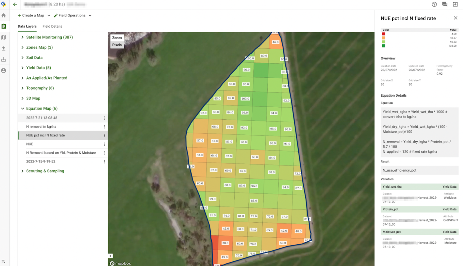
5. Monitoring Crop Response

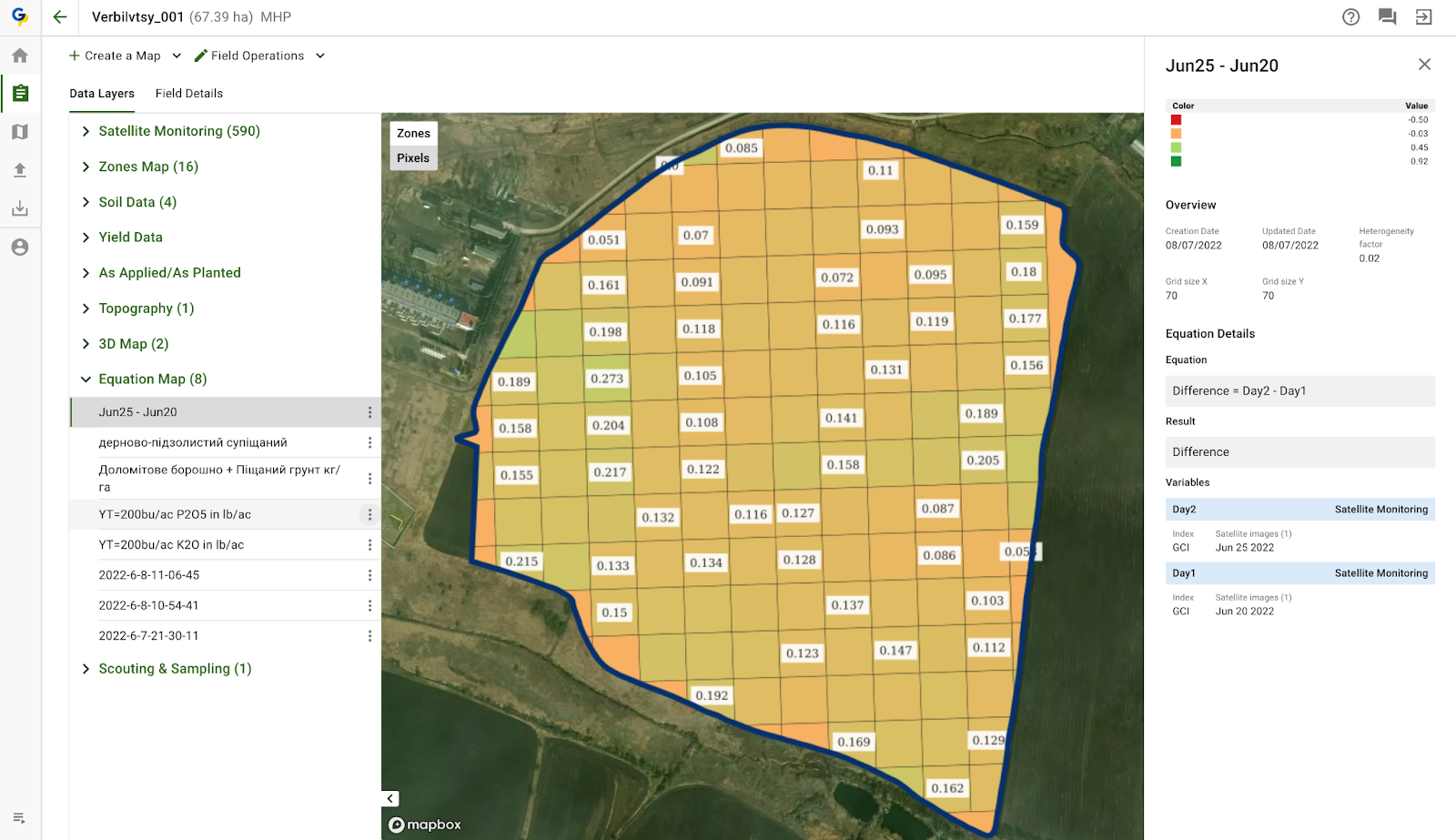
After applying fertilizers, it’s crucial to monitor the crop’s response through regular field observations and data collection. This can include visual assessments of plant health, growth measurements, and more sophisticated methods such as remote sensing and tissue testing.

For instance, chlorophyll meters can measure the greenness of leaves, indicating nitrogen levels in the plants. Similarly, drone or satellite imagery can detect variations in crop health across a field, allowing for timely adjustments.

6. Adaptive Management

Agricultural conditions are dynamic, influenced by weather patterns, pest pressures, and evolving soil health. Therefore, fertilizer strategies must be adaptable. By continually assessing crop performance and environmental conditions, farmers can make informed adjustments to their fertilizer plans. This adaptive management approach ensures that crops receive the right amount of nutrients at the right time, enhancing yield potential and resource use efficiency.

Zaključek

Accurately calculating fertilizer uptake based on yield dry value is fundamental for effective corn production. By understanding nutrient removal rates, conducting soil tests, and considering application efficiency, farmers can optimize fertilizer use, enhance crop yield, and promote environmental sustainability. Adopting best practices and staying informed about advances in precision agriculture and nutrient management can further improve outcomes in corn farming.

What is Phantom Yield Loss In Corn? How to Reduce It?

In the realm of agriculture, the pursuit of optimal crop yield is a perpetual challenge for farmers worldwide. While conventional wisdom often attributes yield losses to readily apparent factors and adverse weather conditions, there exists a more subtle and elusive phenomenon known as Phantom Yield Loss.

It refers to the unexplained reduction in crop yield that cannot be directly attributed to conventional factors like pests, diseases, or adverse weather conditions. Unlike overt threats that manifest visibly, it operates beneath the surface, often eluding detection until its impact becomes evident during harvest.

According to a report by the Food and Agriculture Organization (FAO), an estimated 30% of global crop production is lost each year due to various factors, including it.

This phenomenon challenges the conventional understanding of yield limitations and prompts a more nuanced examination of the agricultural ecosystem. Therefore, its understanding is crucial for farmers and agronomists as it sheds light on factors that may go unnoticed but exert a substantial influence on crop yields.

By acknowledging and addressing these hidden elements, agricultural practices can be refined, and overall productivity improved.

Phantom Yield Loss In Corn

Corn, one of the world’s most essential crops, plays a pivotal role in global food production. However, farmers face numerous challenges in optimizing corn yields, with one significant factor being phantom yield loss.

It is the loss of potential yield that occurs when corn is left to dry down naturally in the field beyond a certain point. It happens because the corn kernels continue to respire and lose weight as they dry, reducing their mass and quality. It is not visible to the eye, but it can have a significant impact on your profits.

Phantom Yield Loss In Corn

According to Eric Frank, a Channel Seedsman based in Frankfort, Indiana, it is “a yield hit that happens to corn when you don’t start harvest earlier. It occurs because you allow the crop to naturally dry down to a certain point before harvest. When it loses that much moisture in the field, it basically cannibalizes itself a little bit.”

How kernel respiration contribute to it?

It happens because the kernels are still alive after reaching black layer, and they continue to respire and use up their stored sugars and starches. This metabolic activity reduces the mass of the kernels and lowers their test weight and quality.

Kernel respiration is the process by which kernels use oxygen and glucose to produce energy, carbon dioxide, and water. It is a normal metabolic activity that occurs throughout the kernel development and maturation stages.

How kernel respiration contribute to Phantom Yield Loss

However, kernel respiration does not stop at physiological maturity, when the black layer forms at the tip of the kernel. The kernel remains alive until it is dried down to a low enough moisture level (around 15%) to kill it. During this period, the kernel continues to respire and lose dry matter.

How much yield can you lose due to it?

That depends on several factors, such as the hybrid, the weather, the soil type, and the harvest timing. However, some studies have shown that it can range from 5 to 15 bushels per acre or more.

For example, in 2020, Farm Journal Field Agronomist Missy Bauer conducted a test plot in an irrigated field with one hybrid. She harvested part of the field on September 23, when the moisture level was 27.9%, and the rest of the field on October 30, when the moisture level was 18.4%. She found that the early harvest yielded 15.6 bushels per acre more than the late harvest, at 214.2 versus 198.6 bushels per acre.

How much yield can you lose due to it?

However, a general rule of thumb is that it starts to occur when corn moisture drops below 13% to 16%. According to some studies, it can range from 0.5% to 1.6% per point of moisture below 15%. This means that a farmer who harvests corn at 12% moisture instead of 15% could lose up to 4.8% of yield due to it alone.

Some further studies have reported yield losses ranging from 5 to 15 bushels per acre with later harvest dates. For example, a five-year study in Nebraska found that yield declined by an average of 9.1 bushels per acre with later harvest, regardless of the change in grain moisture or the duration of time between harvest dates. Similarly, a study in Michigan showed an average yield advantage of 8.9 bushels per acre for earlier harvest.

How to measure it?

The best way to measure it is to compare the yields of corn harvested at different moisture levels in the same field. This can be done by harvesting a portion of the field early, when the corn is still wet (around 25% to 30% moisture), and another portion later, when the corn is dry (around 15% or lower).

The difference in yields between the two portions represents the amount of loss that occurred in the field. For example, if the early-harvested corn yielded 200 bu/acre and the late-harvested corn yielded 190 bu/acre, then the yield loss will be 10 bu/acre or 5%.

Factors that contribute to phantom yield loss

Here are some of the hidden or less apparent factors that contribute to yield loss:

1. Kernel size and shape: Modern corn hybrids have larger and deeper kernels than older ones, which means they have more mass to lose during respiration.

According to Farm Journal Field Agronomist Missy Bauer, today’s kernels average 70,000 to 76,000 per bushel, compared to 90,000 in the past. This means that each kernel has more impact on the final yield and that it can be more significant with newer genetics.

2. Kernel moisture content: The moisture content of the kernels determines how much water they can lose during respiration. The higher the moisture content, the higher the respiration rate and the potential for yield loss.

According to Channel Seedsman Eric Frank, it starts to occur when the kernel moisture drops below 16%. He recommends harvesting corn between 20% and 25% moisture to avoid losing too much weight and quality in the field.

3. Weather conditions: The weather conditions during the dry down period can affect the rate of respiration and yield loss. High temperatures, low humidity, wind and sunlight can increase the evaporation of water from the kernels and accelerate the weight loss.

Factors that contribute to phantom yield loss

Conversely, low temperatures, high humidity, rain and cloud cover can slow down the evaporation and respiration processes and reduce the yield loss. However, these conditions can also increase the risk of mold, disease and insect damage, which can also lower the yield and quality of corn.

4. Harvest timing: The harvest timing is a crucial factor that determines how much it occurs in a corn crop. Harvesting too early can result in high drying costs and lower test weight, while harvesting too late can result in excessive loss and lower grain quality.

The optimal harvest timing depends on several factors, such as hybrid maturity, grain elevator discounts, weather forecast, field conditions and equipment availability. Frank advises farmers to monitor their fields closely and adjust their harvest plans accordingly.

Meanwhile, farmers may face unfavorable conditions that delay or interrupt their harvest plans, such as rain, hail, frost, or snow. These events can damage the stalk integrity and increase the risk of lodging, ear drop, or mold infection, which can further reduce the yield and quality of corn.

How to avoid or reduce it? The early harvesting!

The best way to avoid loss is to harvest corn at the optimal moisture level and use controlled drying methods. Harvesting corn at a higher moisture level (around 20% to 25%) can help preserve kernel weight and quality, as well as reduce field losses due to ear drop, stalk lodging, insect damage, mold growth, and mycotoxin contamination.

However, harvesting wet corn also requires proper drying and storage facilities to prevent spoilage and quality deterioration. Controlled drying methods, such as natural air drying or low-temperature drying, can help reduce kernel damage and shrinkage during the drying process.

How to avoid or reduce Phantom Yield Loss The early harvesting!

Additionally, farmers should consider the economic factors involved in harvesting wet corn versus dry corn. These include grain elevator discounts or premiums for moisture content, drying costs or savings, storage costs or savings, and potential yield or quality losses or gains.

By weighing these factors and using reliable data from their own fields or local sources, farmers can make informed decisions about when to harvest their corn and how to dry it efficiently and effectively.

Another way is to choose hybrids that have good standability and resistance to diseases and pests that can affect stalk strength and ear retention. You can also use agronomic practices that promote healthy plant growth and development, such as proper fertilization, weed control, irrigation, and pest management.

Does PYL can affect other crops?

Yes, it can affect different crops, but not all in the same way. It can harm crops with a lot of moisture content when they are fully grown and take a while to dry out in the field. However, some crops are more at risk than others, based on their seeds, how they respire, and the environment.

Take soybeans, for instance. They’re less likely to have a big PYL problem compared to corn. This is because soybeans have less moisture content when they’re ready to be harvested (about 50% compared to corn’s 70%) and they dry out faster in the field (about 10 days compared to 30 days for corn).

Yet, if soybeans aren’t harvested until they have more than 13% moisture content, they can still lose weight and quality due to breathing, breaking apart, or getting infected by fungi.

Wheat, on the other side, is more at risk than soybeans. This is because wheat has more moisture content when it’s time to harvest (about 60% compared to soybeans’ 50%) and it takes longer to dry out in the field (about 20 days compared to 10 days for soybeans).

Wheat can lose up to 10% of its weight if it’s not harvested until it has more than 14% moisture content, thanks to breathing, breaking apart, sprouting, or diseases.

Other crops like barley, oats, rye, sorghum, sunflower, canola, and alfalfa can also suffer from PYL. How much they’re affected depends on the crop’s makeup, genes, how they’re taken care of, and the weather. That’s why it’s crucial for farmers to keep an eye on their crops’ moisture levels and harvest them at the best time to avoid unnecessary losses.

How GeoPard’s Automated Yield Cleaning and Calibration Can Help with PYL?

At the heart of GeoPard’s solution lies a suite of features designed to automate the cleaning and calibration of yield data. The technology systematically identifies gaps or skips in the yield dataset, ensuring a more reliable representation of actual yields.

How GeoPard's Automated Yield Cleaning and Calibration Can Help with PYL?

By leveraging advanced algorithms, it enhances the precision of monitoring, providing farmers with a trustworthy foundation for decision-making. One of the standout features of GeoPard’s technology is its ability to fill lacked data with synthetic yield maps.

In situations where data gaps exist, it generates synthetic yield maps that seamlessly integrate with the existing dataset. This innovative approach not only ensures a comprehensive yield record but also contributes to a more accurate understanding of crop performance.

The application of GeoPard’s automated cleaning and calibration technology directly translates to a reduction in phantom yield loss. With a more accurate representation of crop yields, farmers can make better-informed decisions regarding crop management, resource allocation, and harvesting timelines. It empowers agricultural stakeholders to overcome the challenges associated with inaccurate data, ultimately leading to improved overall productivity.

Zaključek

It is a subtle yet significant challenge in agriculture, requiring a comprehensive approach to crop management. By recognizing less apparent factors impacting yield, farmers can take proactive measures. Precision farming, soil health management, microbial interactions, climate-smart practices, and crop genetics advancements form a roadmap to address it. Embracing this holistic perspective enables the agricultural community to foster sustainable and resilient food production systems amidst evolving challenges.

Automated Yield Data Cleaning and Calibration

Automated Yield Data Cleaning and Calibration (AYDCC) is a process that uses algorithms and models to detect and correct errors in yield data, such as outliers, gaps, or biases. AYDCC can improve the quality and reliability of yield data, which can lead to better insights and recommendations for farmers.

Introduction to Yield Data

Yield data is one of the most important sources of information for farmers in the 21st century. It refers to the data collected from various farm machinery, such as combines, planters, and harvesters, that measure the quantity and quality of crops produced in a given field or area.

It holds immense importance for several reasons. Firstly, it aids farmers in making informed decisions. Armed with detailed yield data, farmers can fine-tune their practices to maximize productivity.

For instance, if a specific field consistently produces lower yields, farmers can investigate the underlying causes, such as soil health or irrigation issues, and take corrective measures.

Furthermore, it enables precision agriculture. By mapping variations in crop performance across their fields, farmers can tailor their input applications, such as fertilizers and pesticides, to specific areas. This targeted approach not only optimizes resource use but also reduces environmental impacts.

According to the Food and Agriculture Organization (FAO), global agricultural production needs to increase by 60% by 2050 to meet the growing demand for food. Yield data, through its role in enhancing crop productivity, is instrumental in achieving this target.

Furthermore, in Brazil, a soybean farmer used yield data along with soil sampling data to create variable-rate fertilizer maps for his fields. He applied different rates of fertilizer according to the soil fertility and yield potential of each zone.

He also used yield data to compare different soybean varieties and select the best ones for his conditions. As a result, he increased his average yield by 12% and reduced his fertilizer costs by 15%.

Similarly, in India, a rice farmer also used yield datasets along with weather data to adjust his irrigation schedule for his fields. He monitored the soil moisture levels and rainfall patterns using sensors and satellite imagery.

understanding and utilization of yield data

He also used it to compare different rice varieties and select the best ones for his conditions. As a result, he increased his average yield by 10% and reduced his water use by 20%.

Despite its benefits, yield data still faces some challenges in terms of its development and adoption. Some of these challenges are:

  • Data quality: Its accuracy and reliability depends on the quality of the sensors, the calibration of the machinery, the data collection methods, and the data processing and analysis techniques. Poor data quality can lead to errors, biases, or inconsistencies that can affect the validity and usefulness of the data.
  • Data access: The availability and affordability of yield data depend on the access to and ownership of the farm machinery, the sensors, the data storage devices, and the data platforms. Lack of access or ownership can limit the ability of farmers to collect, store, share, or use their own data.
  • Data privacy: Its security and confidentiality depends on the protection and regulation of the data by the farmers, the machinery manufacturers, the data providers, and the data users. Lack of protection or regulation can expose the data to unauthorized or unethical use, such as theft, manipulation, or exploitation.
  • Data literacy: The understanding and utilization of yield data depend on the skills and knowledge of the farmers, the extension agents, the advisors, and the researchers. Lack of skills or knowledge can hinder the ability of these actors to interpret, communicate, or apply the data effectively.
gathering datasets using farm machines like harvesters

Therefore, to overcome these challenges and realize the full potential of yield data, it is important to cleaning and calibrate the yield data.

Introduction to yield data cleaning and calibration

Yield data are valuable sources of information for farmers and researchers who want to analyze crop performance, identify management zones, and optimize decision-making. However, it often require cleaning and calibration to ensure their reliability and accuracy.

Calibrating the “YieldDataset” is a functionality that corrects the distribution of values in alignment with mathematical principles, enhancing the overall integrity of the data. It bolsters the quality of decision-making and renders the dataset valuable for further in-depth analysis.

GeoPard Yield Clean-Calibration Module

GeoPard made it possible to clean and correct yield datasets using its Yield Clean-Calibration module.

We’ve made it easier than ever to enhance the quality of your yield datasets, empowering farmers to make data-driven decisions that you can rely on.

GeoPard - Yield Cleaning & Calibration, similar to Field Potential zones

After calibration and cleaning, the resulting yield dataset becomes homogeneous, without outliers or abrupt changes between neighboring geometries.

With our new module, you can:

Select an option to proceed
  • Remove corrupted, overlapped, and subnormal data points
  • Calibrate yield values across multiple machines
  • Start calibration with just a few clicks (simplifying your user experience) or execute the associated GeoPad API endpoint

Some of the most common use cases of automated yield data cleaning and calibration include:

  • Synchronizing data when multiple harvesters have worked either simultaneously or over several days, ensuring consistency.
  • Making the dataset more homogeneous and accurate by smoothing out variations.
  • Removing data noise and extraneous information that can cloud insights.
  • Eliminating turnarounds or abnormal geometries, which may distort the actual patterns and trends in the field.

In the picture below, you can see a field where 15 harvesters worked at the same time. It shows how the original yield dataset and the improved dataset after calibration with GeoPard yield clean-calibration module look quite different and easy to understand.

difference between the original and improved yield datasets with GeoPard's Calibration Module

Why is it important to clean and calibrate?

Yield data are collected by yield monitors and sensors that are attached to harvesters. These devices measure the mass flow rate and moisture content of the harvested crop, and use GPS coordinates to georeference the data.

However, these measurements are not always accurate or consistent, due to various factors that can affect the performance of the equipment or the crop conditions. Some of these factors are:

1. Equipment variations: Farm machinery, such as combines and harvesters, often have inherent variations that can lead to discrepancies in data collection. These variations might include differences in sensor sensitivity or machinery calibration.

For example, some yield monitors may use a linear relationship between voltage and mass flow rate, while others may use a nonlinear one. Some sensors may be more sensitive to dust or dirt than others. These variations can cause discrepancies in yield data across different machines or fields.

Example 1 U-turns, Stops, Half Equipment Width Used
Example 2 U-turns, Stops, Half Equipment Width Used

2. Environmental factors: Weather conditions, soil types, and topography play significant roles in crop yields. If not accounted for, these environmental factors can introduce noise and inaccuracies into yield data.

For instance, sandy soils or steep slopes may cause lower yields than loamy soils or flat terrains. Likewise, areas with higher crop density may have higher yields than areas with lower density.

3. Sensor inaccuracies: Sensors, despite their precision, are not infallible. They may drift over time, providing inaccurate readings if not regularly calibrated.

For example, a faulty load cell or a loose wiring may cause inaccurate mass flow rate readings. A dirty or damaged moisture sensor may give erroneous moisture content values. A wrong field name or ID entered by the operator may assign yield data to the wrong field file.

These factors can result in yield datasets that are noisy, erroneous, or inconsistent. If these data are not cleaned and calibrated properly, they can lead to misleading conclusions or decisions.

For example, using uncleaned yield data to create yield maps may result in false identification of high- or low-yielding areas within a field.

Why is it important to clean and calibrate yield dataset

Using uncalibrated yield datasets to compare yields across fields or years may result in unfair or inaccurate comparisons. Using uncleaned or uncalibrated yield data to calculate nutrient balances or crop inputs may result in over- or under-application of fertilizers or pesticides.

Therefore, it is essential to perform yield data cleaning and calibration before using them for any analysis or decision-making purpose. Yield datasets cleaning is the process of removing or correcting any errors or noise in the raw yield data collected by the yield monitors and sensors.

Automated methods for cleaning and calibrating yield data

This is where automated data cleaning techniques come in handy. Automated data cleaning techniques are methods that can perform data cleaning tasks without or with minimal human intervention.

Configure the Calibrate step
Automated methods for cleaning and calibrating

Automated data cleaning techniques can save time and resources, reduce human errors, and enhance the scalability and efficiency of data cleaning. Some of the common automated data cleaning techniques for yield data are:

1. Outlier Detection: Outliers are data points that deviate significantly from the norm. Automated algorithms can identify these anomalies by comparing data points to statistical measures such as mean, median, and standard deviation.

For example, if a yield dataset shows an exceptionally high harvest yield for a particular field, an outlier detection algorithm can flag it for further investigation.

2. Noise Reduction: Noise in yield data can arise from various sources, including environmental factors and sensor inaccuracies.

Automated noise reduction techniques, such as smoothing algorithms, filter out erratic fluctuations, making the data more stable and reliable. This helps in identifying true trends and patterns in the data.

3. Data Imputation: Missing data is a common issue in yield data sets. Data imputation techniques automatically estimate and fill in missing values based on patterns and relationships within the data.

For instance, if a sensor fails to record data for a specific time period, imputation methods can estimate the missing values based on adjacent data points.

Hence, automated data cleaning techniques serve as the gatekeepers of data quality, ensuring that yield datasets remain a reliable and valuable asset for farmers worldwide.

Furthermore, there are lots of handy tools and computer programs that can automatically clean and adjust yield data, and GeoPard is one of them. The GeoPard Yield Clean-Calibration Module, along with similar solutions, is super important for making sure the data is accurate and reliable.

GeoPard - Yield Cleaning & Calibration - 3 harvesters

Zaključek

Automated Yield Data Cleaning and Calibration (AYDCC) is essential in precision agriculture. It ensures the accuracy of crop data by removing errors and enhancing quality, enabling farmers to make informed decisions. AYDCC addresses data challenges and utilizes automated techniques for trustworthy results. Tools like GeoPard’s Yield Clean-Calibration Module simplify this process for farmers, contributing to efficient and productive farming practices.

Automated Field Boundaries Detection Model for Precision Agriculture by GeoPard

GeoPard have completed a successful development of an automated field boundaries detection model using mutli-year satellite imagery, accurate cloud and shadow detection, and advanced proprietary algorithms, including deep neural networks.

The GeoPard field detection model has achieved a state-of-the-art accuracy of 0.975 on the Intersection over Union (IoU) metric, validated across diverse regions and crop types globally.

Check out these images to see the results in Germany (average field size is 7 hectares):

1 - Raw Sentinel-2 image

1 – Raw Sentinel-2 image

3 - Segmented field boundaries

2 – Super-resolution Sentinel-2 image by GeoPard (1 meter resolution)

2 - Super-resolution Sentinel-2 image by GeoPard

3 – Segmented field boundaries, 0.975 Intersection over union (IoU) accuracy metric, across multiple international regions and crop types.


Integration into our API and GeoPard application is coming soon. This automated and cost-effective method helps predict yields, benefits governmental organizations, and assists large landowners who often need to update field boundaries between seasons.

GeoPard’s approach utilizes multi-year crop vegetation trends using multi-factor analysis and crop rotation.


The model is accessible via the GeoPard API on a pay-as-you-go basis, offering flexibility without the need for costly subscriptions.


What is Field Boundaries Delineation?

Field boundaries delineation refers to the process of identifying and mapping the boundary of agricultural fields or parcels of land. It involves using various techniques and data sources to demarcate the limits of individual fields or agricultural plots.

Traditionally, field boundaries were delineated manually by farmers or landowners based on their knowledge and observations.

However, with advancements in technology, particularly in remote sensing and geographic information systems (GIS), automated and semi-automated methods have become increasingly prevalent.

One common approach is the analysis of satellite or aerial imagery. High-resolution images captured by satellites or aircraft can provide detailed information about the landscape, including the boundaries between different land parcels.

Image processing algorithms can be applied to these images to detect distinct features such as changes in vegetation type, color, texture, or patterns that indicate the presence of field boundaries.

Another technique involves using LiDAR (Light Detection and Ranging) data, which uses laser beams to measure the distance between the sensor and the Earth’s surface.

LiDAR data can provide detailed elevation and topographic information, allowing for the identification of subtle variations in terrain that may correspond to field boundaries.

Additionally, geographic information systems (GIS) play a crucial role in delineation of field boundaries.

GIS software allows for the integration and analysis of various data layers, including satellite imagery, topographic maps, land ownership records, and other relevant information. By combining these data sources, GIS can aid in the interpretation and identification of field boundaries.

The accurate delineation of field is essential for several reasons. It facilitates better management of agricultural resources, enables precision farming techniques, and supports the planning and implementation of agricultural practices such as irrigation, fertilization, and pest control.

Accurate field boundary data also assists in land administration, land-use planning, and compliance with agricultural regulations.

How it is useful?

It plays a crucial role in agriculture and land management, providing several benefits and importance supported by evidence and global figures. Here are some key points:

1. Precision Agriculture: Accurate field boundaries help in implementing precision agriculture techniques, where resources such as water, fertilizers, and pesticides are precisely targeted to specific areas within fields.

According to a report by the World Bank, precision agriculture technologies have the potential to increase crop yields by 20% and reduce input costs by 10-20%.

2. Efficient Resource Management: It enables farmers to better manage resources by optimizing irrigation systems, adjusting fertilization practices, and monitoring crop health. This precision reduces resource wastage and environmental impact.

The Food and Agriculture Organization (FAO) estimates that precision agriculture practices can reduce water usage by 20-50%, decrease fertilizer consumption by 10-20%, and reduce pesticide usage by 20-30%.

3. Land Use Planning: Accurate field boundary data is essential for land use planning, ensuring efficient utilization of available agricultural land. It allows policymakers and land managers to make informed decisions regarding land allocation, crop rotation, and zoning.

This can lead to increased agricultural productivity and improved food security. A study published in the Journal of Soil and Water Conservation found that effective land use planning could increase global food production by 20-67%.

4. Farm Subsidies and Insurance: Many countries provide agricultural subsidies and insurance programs based on field boundaries. Accurate delineation helps in determining eligible land areas, ensuring fair distribution of subsidies, and calculating insurance premiums accurately.

For instance, the European Union’s Common Agricultural Policy (CAP) relies on accurate field boundaries for subsidy calculations and compliance monitoring.

5. Land Administration and Legal Boundaries: Field boundaries delineation in agriculture is crucial for land administration, property rights, and resolving land disputes. Accurate maps of field boundaries help establish legal ownership, support land registration systems, and facilitate transparent land transactions.

The World Bank estimates that only 30% of the world’s population has legally documented rights to their land, highlighting the importance of reliable field boundary data for secure land tenure.

6. Compliance and Environmental Sustainability: Accurate field boundaries aid in compliance monitoring, ensuring adherence to environmental regulations and sustainable farming practices.

It helps identify buffer zones, protected areas, and areas prone to erosion or water contamination, enabling farmers to take appropriate measures. Compliance with environmental standards enhances sustainability and reduces negative impacts on ecosystems.

According to the FAO, sustainable farming practices can mitigate up to 6 billion tons of greenhouse gas emissions annually.

These points illustrate its usefulness and importance in agriculture and land management. The evidence and global figures presented support the positive impacts it can have on resource efficiency, land use planning, legal frameworks, environmental sustainability, and overall agricultural productivity.

In summary, field boundaries delineation in agriculture is the process of identifying and mapping the boundary of agricultural fields or parcels of land. It relies on various techniques such as satellite imagery analysis, LiDAR data, and GIS to accurately define and demarcate these boundaries, enabling effective land management and agricultural practices.

Equation-based Analytics in Precision Agriculture

With the release of the Equation-based analytics module, the GeoPard team has taken a big step forward in empowering farmers, agronomists, and spatial data analysts with actionable insights for each square meter. The module includes a catalog of over 50 predefined GeoPard precision formulas that cover a wide range of agriculture-related analytics.

The precision formulas have been developed based on multi-year independent agronomic university and industry research and have been rigorously tested to ensure their accuracy and usefulness. They can be easily configured to be executed automatically for any field, providing users with powerful and reliable insights that can help them to optimize their crop yields and reduce input costs.

The Equation-based analytics module is a core feature of the GeoPard platform, providing users with a powerful tool to gain a deeper understanding of their operations and make data-driven decisions about their farming practices. With the ever-growing catalog of formulas and the ability to customize formulas for different field scenarios. The GeoPard can meet the specific needs of any farming operation.


Potassium Removal based on Yield data

Potassium Removal based on Yield data


Use Cases (see examples below):

  • Nitrogen Uptake in absolute numbers using Yield and Protein data
  • Nitrogen Use Efficiency (NUE) and Excess calculations with Yield and Protein data layers
  • Lime recommendations based on pH data from soil sampling or soil scanners
  • Sub-field (zones or pixel-level ROI maps)
  • Micro and Macro nutrients fertilization recommendations based on Soil sampling, Field Potential, Topography, and Yield data
  • Carbon modeling
  • Change detection and alerting (calculate difference between Sentinel-2, Landsat8-9 or Planet imagery)
  • Soil and grain moisture modeling
  • Calculation of dry yield out of wet yield datasets
  • Target Rx vs As-applied maps difference calculation


Potassium Recommendations based on Two Yield Targets (Productivity Zones)

Potassium Recommendations based on Two Yield Targets (Productivity Zones)


Fertilizer: Recommendations Guide. Potassium / Corn.

Fertilizer: Recommendations Guide (South Dakota State University): Potassium / Corn. Review and Revision: Jason Clark | Assistant Professor & SDSU Extension Soil Fertility Specialist


Potassium Use Efficiency in Kg/Ha

Potassium Use Efficiency in Kg/Ha


Nitrogen Use Efficiency in percentage. Calculation is based on Yield, Protein and Grain Moisture data layers

Nitrogen Use Efficiency in percentage. Calculation is based on Yield, Protein and Grain Moisture data layers


Nitrogen: Target Rx vs As-Applied

Nitrogen: Target Rx vs As-Applied


Chlorophyll difference between two satellite images

Chlorophyll difference between two satellite images


A user of GeoPard can adjust existing and create their private formulas based on Imagery, Soil, Yield, Topography, or any other data layers GeoPard supports. 

Examples of the template GeoPard Equations

Examples of the template GeoPard Equations


Formula-based analytics helps farmers, agronomists, and data scientists to automate their workflows and make decisions based on multiple data and scientific research to enable easier implementation of sustainable and precision agriculture.

What is Equation-based Analytics in Precision Agriculture? The Use of Precision Formula

Equation-based analytics in precision agriculture refers to the use of mathematical models, equations, precision formula, and algorithms to analyze agricultural data and derive insights that can help farmers make better decisions about crop management.

These analytics methods incorporate various factors such as weather conditions, soil properties, crop growth, and nutrient requirements to optimize agricultural practices and improve crop yields, while minimizing resource waste and environmental impact.

Some of the key components of equation-based analytics in precision agriculture include:

  • Crop growth models: These models describe the relationship between various factors such as weather, soil properties, and crop management practices, to predict crop growth and yield. Examples of such models include the CERES (Crop Environment Resource Synthesis) and APSIM (Agricultural Production Systems sIMulator) models. These models can help farmers make informed decisions about planting dates, crop varieties, and irrigation scheduling.
  • Soil water models: These models estimate the water content in the soil profile based on factors such as rainfall, evaporation, and crop water use. They can help farmers optimize irrigation practices, ensuring that water is applied efficiently and at the right time to maximize crop yields.
  • Nutrient management models: These models predict nutrient requirements for crops and help farmers determine the optimal rates and timing of fertilizer application. By using these models, farmers can ensure that crops receive the right amount of nutrients, while minimizing the risk of nutrient runoff and environmental pollution.
  • Pest and disease models: These models predict the likelihood of pest and disease outbreaks based on factors such as weather conditions, crop growth stages, and management practices. By using these models, farmers can make proactive decisions about pest and disease management, such as adjusting planting dates or applying pesticides at the right time.
  • Remote sensing-based models: These models use satellite imagery and other remote sensing data to monitor crop health, detect stress factors, and estimate yield. By integrating this information with other data sources, farmers can make better decisions about crop management and optimize resource use.

In summary, equation-based analytics in precision agriculture uses mathematical models and algorithms to analyze complex interactions between various factors that affect crop growth and management. By leveraging these analytics, farmers can make data-driven decisions to optimize agricultural practices, improve crop yields, and minimize environmental impact.


Pogosta vprašanja


1. How can precision agriculture help address resource use and pollution issues in agriculture?

It can help address resource use and pollution issues in agriculture through targeted resource application, efficient resource management, enhanced monitoring, and the adoption of conservation practices. By applying inputs such as fertilizers and pesticides only where needed, farmers can reduce waste and minimize pollution.

Data-driven decision-making enables optimal resource management, while real-time monitoring allows for timely interventions to prevent pollution incidents. Additionally, the implementation of conservation practices promotes sustainable agriculture and reduces environmental impacts.

GeoPard Field Potential maps vs Yield data

GeoPard Field Potential maps very often look exactly like yield data.

We create them using multi-layer analytics of historical information, topography, and bare soil analysis.

The process of such synthetic Yield maps is automated (and patented) and it takes about 1 minute for any field in the world to generate it.


GeoPard Field Potential maps vs Yield data

Can be used as the basis for:

What are Field Potential maps?

Field potential maps, also known as yield potential maps or productivity potential maps, are visual representations of the spatial variability in potential crop yield or productivity within a field. These maps are created by analyzing various factors that influence crop growth, such as soil properties, topography, and historical yield data.

These maps can be used in precision agriculture to guide management decisions, such as variable-rate application of fertilizers, irrigation, and other inputs, as well as to identify areas that require specific attention or management practices.

Some key factors that are typically considered when creating field potential maps include:

  1. Soil properties: Soil characteristics such as texture, structure, organic matter content, and nutrient availability play a significant role in determining crop yield potential. By mapping soil properties across a field, farmers can identify areas of high or low productivity potential.
  2. Topography: Factors like elevation, slope, and aspect can influence crop growth and yield potential. For example, low-lying areas may be prone to waterlogging or have a higher risk of frost, while steep slopes may be more susceptible to erosion. Mapping these topographical features can help farmers understand how they affect productivity potential and adjust their management practices accordingly.
  3. Historical yield data: By analyzing historical yield data from previous years or seasons, farmers can identify trends and patterns in productivity across their fields. This information can be used to create these maps that highlight areas of consistently high or low yield potential.
  4. Remote sensing data: Satellite imagery, aerial photography, and other remote sensing data can be used to assess crop health, vigor, and growth stage. This information can be used to create these maps that reflect the spatial variability in crop productivity potential.
  5. Climate data: Climate variables such as temperature, precipitation, and solar radiation can also influence crop growth and yield potential. By incorporating climate data into these maps, farmers can better understand how environmental factors affect productivity potential in their fields.

They are valuable tools in precision agriculture, as they help farmers visualize the spatial variability in productivity potential within their fields. By using these maps to guide management decisions, farmers can optimize the use of resources, improve overall crop yields, and reduce the environmental impact of their agricultural operations.

Difference between Field Potential maps vs Yield data

Field potential maps and yield data are both used in precision agriculture to help farmers understand the spatial variability in their fields and make better-informed management decisions. However, there are some key differences between the two:

Data sources:

These maps are created by integrating data from various sources, such as soil properties, topography, historical yield data, remote sensing data, and climate data. However, this data is collected using yield monitors installed on harvesting equipment, which record the crop yield as it is harvested.

Temporal aspect:

These maps represent an estimation of the potential productivity of a field, which is generally static or changes slowly over time, barring significant changes in soil properties or other influencing factors. However, yield data is specific to a particular growing season or multiple seasons and can vary significantly from year to year based on factors like weather conditions, pest pressure, and management practices.

In summary, field potential maps and yield data are complementary tools in precision agriculture. These maps provide an estimate of the potential productivity of a field, helping farmers identify areas that may require different management practices. Yield data, on the other hand, documents the actual crop output and can be used to assess the effectiveness of management practices and inform future decision-making.

Avtomatizirano pregledovanje posevkov s križanjem podatkovnih slojev

V programu GeoPard imamo modul za samodejno ustvarjanje območij za pregledovanje podatkov o pridelkih s prilagodljivo konfiguracijo poslovne in agronomske logike.

Omogoča nadzor ogromne količine polj in pregledovanje le v nujnih primerih.

Poslovna/agronomska logika je lahko prilagodljiva. V tem primeru so naloge ustvarjene na območjih, kjer imamo na najnovejših satelitskih posnetkih območja z visokim zgodovinskim poljskim potencialom in nizko vegetacijo.

Primer drugega primera uporabe: območje nizkega donosa (iz datoteke o donosu), ki se križa z območji z nizkim pH - za prilagajanje ravni apnenja.


Avtomatizirana območja iskanja podatkov o poljščinah s križanjem podatkovnih slojev
Območja z visoko zgodovinsko produktivnostjo polja, ki se križajo z najnovejšo sliko Planeta z nizko stopnjo vegetacije -> naloge raziskovanja se samodejno ustvarijo v programu GeoPard.

Za podjetja za trgovanje s pridelki in podatkovne modelarje je lahko presečišče med zgodovinsko najbolj stabilnimi območji in območji z visokim pridelkom dober kazalnik za ekstrapolacijo napovedi pridelka.

Če ste kmet, agronom ali strokovnjak za precizno kmetijstvo, veste, kako pomembno je iskanje podatkov o pridelkih. Bistveno je za spremljanje zdravja vaših pridelkov in prepoznavanje morebitnih težav, preden postanejo velike.

Vendar je tradicionalno pregledovanje posevkov lahko zamudno in delovno intenzivno. Tu pridejo na vrsto avtomatizirane naloge pregledovanja.

GeoPard je revolucionarna avtomatizirana programska oprema za natančno kmetijstvo, ki z uporabo naprednih algoritmov in satelitskih posnetkov samodejno spremlja vaše pridelke. S programom GeoPard lahko preprosto nastavite samodejne naloge pregledovanja, ki vas bodo opozorile na morebitne težave, kot so škodljivci, bolezni ali pomanjkanje hranil.

Ena od ključnih prednosti uporabe samodejnih pregledov je možnost hitrega in natančnega prepoznavanja težav v pridelkih. Program GeoPard uporablja napredne algoritme za analizo satelitskih posnetkov vaših polj in tako zazna tudi najmanjše spremembe v vaših pridelkih.

To pomeni, da lahko hitro ugotovite morebitne težave in jih odpravite, še preden postanejo resnejše.

Še ena prednost samodejnih pregledov je možnost rednega spremljanja pridelkov. Pri tradicionalnem pregledovanju je težko redno obiskovati polja in preverjati morebitne težave.

S programom GeoPard pa lahko nastavite samodejna opravila, ki bodo dnevno ali tedensko spremljala vaše pridelke in vam omogočila celovitejši pregled nad njihovim zdravjem.

GeoPardova samodejna raziskovalna opravila so tudi prilagodljiva, tako da jih lahko prilagodite svojim posebnim potrebam. Nastavite lahko naloge za spremljanje določenih težav, kot so škodljivci ali bolezni, ali pa nastavite naloge za spremljanje določenih območij na polju. To pomeni, da lahko dobite informacije, ki jih potrebujete za sprejemanje premišljenih odločitev o svojih pridelkih.

Poleg samodejnega raziskovanja GeoPard ponuja tudi vrsto drugih funkcij, ki vam lahko pomagajo pri upravljanju operacij natančnega kmetijstva. S programom GeoPard lahko načrtujete sajenje in gnojenje, spremljate stopnjo vlage v tleh in spremljate svoj pridelek.

Na splošno so samodejna raziskovalna opravila programa GeoPard močno orodje za kmete, agronome in strokovnjake za precizno kmetijstvo. S programom GeoPard lahko hitro in enostavno spremljate svoje pridelke in prepoznate morebitne težave, kar vam pomaga pri sprejemanju boljših odločitev o vaših dejavnostih.

Kaj je raziskovanje poljščin?

Pregledovanje posevkov je praksa v kmetijstvu, ki vključuje sistematično pregledovanje in spremljanje posevkov za oceno njihovega zdravja, rasti in morebitnih težav. Običajno vključuje fizično hojo po poljih ali uporabo tehnologije, kot so brezpilotna letala ali senzorji, za zbiranje podatkov.

Pregledniki pridelkov opazujejo in zbirajo informacije o dejavnikih, kot so napadi škodljivcev, izbruhi bolezni, pomanjkanje hranil in pritisk plevelov.

Ti podatki pomagajo kmetom pri sprejemanju premišljenih odločitev glede upravljanja pridelkov, kot so izvajanje ciljno usmerjenih tretiranj, prilagajanje uporabe gnojil ali izvajanje strategij za nadzor škodljivcev. Podatki imajo ključno vlogo pri povečanju pridelka in zagotavljanju splošnega zdravja pridelka.

Kaj je avtomatizirano iskanje podatkov o pridelkih?

Avtomatizirano pregledovanje pridelkov pomeni uporabo najsodobnejših tehnologij, vključno z robotiko, brezpilotnimi zrakoplovi (UAV), različnimi senzorji in umetno inteligenco, za opazovanje in ocenjevanje zdravja in razvoja pridelkov v kmetijskem okolju.

Cilj je povečati učinkovitost, zmanjšati stroške in poenostaviti upravljanje pridelkov z avtomatizacijo nalog, ki so jih običajno opravljali človeški izvidniki.

Postopek avtomatiziranega iskanja podatkov o pridelkih vključuje več faz, kot so:

  • Zbiranje podatkov: Brezpilotna letala ali kopenski roboti, opremljeni z različnimi senzorji (npr. kamerami, večspektralnimi senzorji, LIDAR), pridobivajo informacije o stanju pridelkov, ki vključujejo zdravje rastlin, pojav škodljivcev in bolezni, lastnosti tal in koncentracijo hranil.
  • Analiziranje podatkov: Zbrani podatki se nato obdelajo in pregledajo z uporabo umetne inteligence in algoritmov strojnega učenja, da se odkrijejo vzorci, nepravilnosti in težnje, povezane z zdravjem in razvojem pridelkov.
  • Sprejemanje odločitev: Rezultate analize podatkov je mogoče uporabiti za sprejemanje premišljenih odločitev o upravljanju pridelkov, vključno z optimizacijo zalivanja, gnojenja, varstva pred škodljivci in drugih posegov.
  • Ukrepanje: Kmetje lahko na podlagi znanja, pridobljenega s samodejnim spremljanjem pridelkov, izvajajo ciljno usmerjene ukrepe za reševanje določenih težav na polju, kot je uporaba pesticidov ali hranil samo tam, kjer je to potrebno, kar zmanjšuje količino odpadkov in vpliv na okolje.

Z zagotavljanjem natančnih podatkov kmetom v realnem času se lahko znatno povečata kmetijska produktivnost in trajnost, kar omogoča boljše sprejemanje odločitev in izvajanje natančnejših tehnik upravljanja.

Kako prepoznati skavtsko območje?

Določanje območij za iskanje podatkov o pridelkih vključuje razdelitev kmetijskega polja na manjše, obvladljive dele na podlagi vidikov, kot so sestava tal, teren, pretekli rezultati pridelave ali drugi ustrezni dejavniki.

Cilj je vzpostaviti enotna območja s podobnimi razmerami, kar omogoča bolj usmerjeno raziskovanje, opazovanje in upravljanje. V nadaljevanju je predstavljena metoda za določanje območja pregledovanja poljščin, ki poteka korak za korakom:

  • Zberite zgodovinske informacije: Zberite podatke o prejšnjih pridelkih, rezultatih analize tal, pojavu škodljivcev in bolezni ter vse druge pomembne informacije o polju. Ti podatki lahko pomagajo prepoznati območja s primerljivimi pogoji ali uspešnostjo.
  • Preučite sestavo tal in teren: Preučite vrste tal in teren svojega polja, da boste razumeli naravne razlike. Različna sestava tal in nadmorska višina lahko vplivata na rast pridelkov, absorpcijo hranil in dostopnost vode, kar posledično vpliva na zdravje pridelkov.
  • uporaba tehnologije daljinskega zaznavanja: Uporabite satelitske posnetke ali posnetke iz dronov, da pridobite dodatne podrobnosti o razmerah na polju, kot so indeksi vegetacije, stopnja vlage v tleh in nihanje temperature. Te informacije lahko pomagajo natančneje določiti območja pregledovanja, saj zagotavljajo celovitejši pogled na polje.
  • Izvajanje tehnik natančnega kmetijstva: Za obdelavo in analizo zbranih podatkov uporabite programsko opremo za precizno kmetijstvo. Ta orodja lahko pomagajo pri prepoznavanju vzorcev in določanju podatkovno usmerjenih območij za pregledovanje, pri čemer upoštevajo dejavnike, kot so zdravje pridelka, spremenljivost tal in teren.
  • Vzpostavitev raziskovalnih območij: Na podlagi analize podatkov razdeli polje na manjša, enotna območja s podobnimi značilnostmi. Ta območja morajo biti obvladljiva po velikosti in prilagojena posebnim zahtevam vaše dejavnosti.
  • Redno posodabljajte in prilagajate: Ko se okoliščine spremenijo in so na voljo novi podatki, ponovno ocenite in spremenite območja raziskovanja, da bodo še naprej ustrezna in natančna. To lahko vključuje posodobitev območij na podlagi novih podatkov o donosu, pojavu škodljivcev in bolezni ali drugih dejavnikov, ki vplivajo na uspešnost pridelka.

Zato lahko kmetje z natančno določitvijo in oblikovanjem območja pregledovanja pridelkov učinkoviteje usmerijo svoja prizadevanja za spremljanje in uporabljajo ciljno usmerjene prakse upravljanja, kar vodi k boljši uporabi virov in boljšemu zdravju pridelkov.

Yield data and analytics in GeoPard

In this article:

  • Using yield analytics in precision agriculture
  • In-depth yield data analytics in GeoPard Agriculture 
  • Visualization of each attribute in Yield files
  • Correction of raw yield data 
  • 5 Practical examples of usage of yield maps
Raw and cleaned yield data in GeoPard

Podatki o donosu allows you to make more informed decisions and improve growing efficiency.
Field management zones constructed from multiple years of yield data are suitable for an initial assessment of potential yield and soil nutrient variability to make future crop management decisions.

Analysis of yield data can be converted to a variable rate application map and used, for example, for fertilizer application. Its calibration is another topic you need to consider, we will cover it in a separate blog post.

The advanced analytics in GeoPard is that you can perform multi-layer analysis by combining multiple layers of data into one map and looking for relationships between the data layers. 

Combined productivity zones can be generated based on vegetation indices from satellite imagery, topography, data from machinery such as yield, electrical conductivity, soil moisture, and others, as well as agrochemical analysis results.

Visualization of yield files is done automatically after downloading the file, it’s automatic processing and cleaning. Two versions of maps are shown below – the original image with data from the equipment monitor as is, and the GeoPard visualization.

The raw data has been converted into a gradient continuous surface image, for an easier understanding of the field heterogeneity and for creating management zones.

Each of the attributes of the yield file is available for visualization, such as moisture, yield mass, yield volume wet and dry, downforce, fuel consumption, machine speed, and so on.

Raw data correction means that if a point in the field is unnatural, it will be smoothed (for example, working over not the full width of the combine header). When creating Zones-based yield data, you can correct individual zones and polygons. 

Let’s take a look at some practical examples of using yield maps and other GeoPard data layers.

1. Management zones based on yield data. Management zones can be constructed based on either one year’s yield data or multiple years. It is important to note that you cannot directly stack yields from different years, as you will get a bias in favor of one of the years.

To reduce this effect, GeoPard applies several algorithms to make the weight of each year even.  You can set the importance of a single year through the Weight tool when you create a Multi-layer map.

Such field management zones can be used to build application/prescription/Rx (VRA) maps, calculating the potential yield in each zone.

Multi-year and multi-layer yield potential map

2. Multi-layer zones with yield data and other data sources (topography, soil, sensor, satellite). It can be added to multilayer analytics and set the weight it will have on the final zones.

In this example, three layers of data are added to the map: Yield, Satellite imagery, and Topography. You can combine any data layers you consider relevant for analytics. The multi-layer map can be used for further yield analytics and for creating VRA maps. 

Yield, Topography and Satellite imagery
Multi-layer zones: Yield, Topography and Satellite imagery

3. Yield calculation on zone and field level. To analyze different treatments, seed varieties, and agronomic practices you probably want to compare the average and total yield in each zone, strip, or between fields.

GeoPard automatically calculates this for you to make it easier to compare yield in absolute numbers. 

GeoPard calculates yield in abs numbers based on Yield files. Total and average for field and each zone

4. Dependency zones based on yield data. Zones based on yield data can be overlaid on other data zones and you can search for dependencies between data layers. This example shows the overlay of high yield and average protein (1) and low yield and high protein (2) of different wheat varieties in a field.

Other examples include the relationship between the influence of topography on yield, the intersection between low yields, and the lack of macro-and micronutrients in the soil, soil moisture, and electrical conductivity (EC) layers.

Intersections of different yield and protein levels

5. Variable Rate application (VRA) maps based on yield data.  You can create prescription maps for different operations – fertilizing, seeding, spraying, irrigation, and planning of soil sampling. You can edit the number and shape of the zones.

You can also build a prescription map for a variable rate application by combining yield data with other data sources (soil, EC, satellite, topography). 

Variable rate Seeding rates per zone
Variable-rate Seeding rates per zone

Even if you do not have yield data, you can use GeoPard multi-year zones (up to 33 years) based on satellite imagery or combine it with other data layers like topography to start your precision agriculture journey. These analyses often correlate with yield analytics data, but this is another story.


Pogosta vprašanja


1. How to do yield analysis?

Yield analysis is a process used to assess the productivity and performance of a crop or agricultural system. Here are the steps to conduct a basic yield analysis:

  • Measure the total harvested yield: Collect all the harvested produce from a specific area and weigh it.
  • Determine the area: Measure or calculate the total area of land from which the yield was obtained.
  • Calculate the yield per unit area: Divide the total harvested yield by the area to get the yield per unit area (e.g., yield per hectare).
  • Compare and analyze: Compare the obtained yield with previous years’ data or regional averages to assess the performance and identify any variations or trends.

Yield analysis helps farmers make informed decisions, monitor crop productivity, and identify areas for improvement in their farming practices.

2. What is yield data?

Yield data refers to the information collected and recorded about the amount of crop or agricultural produce obtained from a specific area of land. It includes measurements or estimates of the quantity of harvested yield, usually expressed in terms of weight or volume.

It provides valuable insights into the productivity and performance of crops, helping farmers make informed decisions about their farming practices, assess the effectiveness of different techniques or inputs, and monitor trends or variations in crop yields over time.

3. What is yield potential?

Yield potential refers to the maximum achievable yield or production level of a crop under ideal growing conditions. It represents the upper limit of what a specific crop variety or plant species can yield in terms of quantity and quality.

Yield potential is influenced by various factors such as genetics, environmental conditions, nutrient availability, and management practices. It serves as a benchmark or reference point for farmers and agronomists to evaluate the performance and productivity of different crop varieties and to identify areas where improvements can be made to optimize yield levels.

Multi layer (integrated) data analysis in precision agriculture

Precision agriculture is capable of generating vast amounts of data in the form of yield data, satellite imagery, and soil fertility, among others.

The lack of easy-to-use cloud precision software toolkits that assist crop producers in converting field data layers into useful knowledge and actionable recommendations limits the application of precision agricultural technologies.

In precision agriculture, management zones are areas within a field that have similar yield potential based on soil type, slope position, soil chemistry, microclimate, and/or other factors that influence crop production.

The producer’s knowledge of a field is a very important piece of the process. Management zones are thought of as a mechanism to optimize crop inputs and yield potential.

Maps generated with a single data layer and several data layers.

The big challenge is to build management zones that perfectly reflect field variability. A combination of different layers like satellite imagery, soil fertility, topography derivatives, and yield monitor data is the next logical step to generating more responsive management zones.

Multi layer analytics (also known as integrated analysis) is becoming a part of the GeoPard geospatial analytics engine.

Classic combinations of integrated analysis parameters include one or more yield data, NDVI map, elevation, and soil sensor physicochemical characteristics. 

GeoPard supports these parameters and in addition, allows the inclusion of other field data layers either already available in the system or uploaded directly by the user (soil sampling, yield datasets, etc.).

As a result, you are free to operate with the complete set of parameters doing integrated analytics:

Multi layer yield data analytics

Remote sensing data:

  • Potential productivity map (single-year and multi-year)
  • Stability/variation map
  • Vegetation indices NDVI, EVI2, WDRVI, LAI, SAVI, OSAVI, GCI, GNDVI

Topography:

  • Digital elevation
  • Slope
  • Curvature
  • Wetness index
  • Hillshades

Soil data:

  • pH
  • CEC (cation exchange capacity)
  • SOM (soil organic matter)
  • K (potassium)
  • Thin topsoil depth, lower available water holding capacity (drought-prone soil)
  • EC (electrical conductivity)
  • and other chemical attributes available in the uploaded dataset

It’s important to emphasize that custom factors are configured on top of every data layer to assign the desired layer weight. You are very welcome to share your integrated analytics use cases, and build management zone maps based on your knowledge of the field while selecting data sources and their weights in GeoPard.

Pictures in this blog contain a sample field with data layers (like a productivity map covering 18 years, digital elevation model, slope, hillshade, 2019 yield data) and various combinations of integration analytics maps. 

You can follow the steps of the evolution of management zones while extending integration analytics with an additional data layer.


Pogosta vprašanja


1. What is data layers?

Data layers refer to the individual components or elements of data that are organized and stacked together to create a comprehensive representation of a specific area or subject.

Each layer represents a specific aspect of the data, such as geographical features, land use, population density, or environmental factors. These layers can be combined and analyzed collectively to gain insights, visualize patterns, and make informed decisions.

Data layers are commonly used in geographic information systems (GIS) and spatial analysis to better understand and represent complex data in a visual and interpretable manner.

2. What is integrated analysis?

Integrated analysis refers to the process of combining and analyzing data from multiple sources or disciplines to gain a more comprehensive and holistic understanding of a particular problem or phenomenon.

It involves merging data sets, applying statistical techniques, and exploring relationships across different variables or domains.

Integrated analysis allows for a more nuanced and interconnected view of complex systems, facilitating the identification of patterns, trends, and causal relationships that may not be evident when analyzing data in isolation.

This approach enables researchers and decision-makers to make more informed and effective decisions based on a broader range of information.

wpChatIcon
wpChatIcon

    Zahtevaj brezplačno GeoPard predstavitev / posvet

    Zdravo


    S klikom na gumb soglašate z našimi Pravilnik o zasebnosti. Potrebujemo ga za odgovor na vašo zahtevo.

      Naročite se na


      S klikom na gumb soglašate z našimi Pravilnik o zasebnosti

        Pošljite nam informacije


        S klikom na gumb soglašate z našimi Pravilnik o zasebnosti