GeoPard is continuously improving its capabilities to process various types of in-field datasets. High-density sensor datasets are supported by our analytics core for further research and collecting field insights.


A user has access to capabilities to import, visualize, analyze, and research geo-referenced high-density data. These operations are supported via the Web/Mobile user interfaces and API.
Analytics capabilities cover:
- Supporting data formats either points and polygons
- Processing of sensor data to correct the data and to build a continuous surface for a field boundary
- Customizing of color schemas to set preferred color codes and classification
- Generating of management zones and further creation of Variable Rate Application
- Using as a part of multi-layers и cross-layers analytics
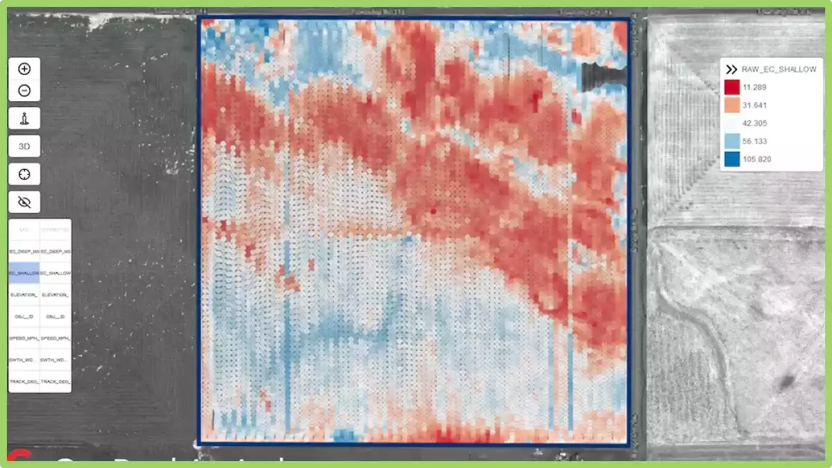
 An example of Electrical Conductivity data collected by our partners.
For agricultural consultants, agronomists, and growers it means more field-collected data can be stored, analyzed, and used in daily operations in a single solution and easily available for data exploration.
For local sensor companies, GeoPard is an excellent tool that supports analytics of the data collected by such companies and provides contextual information: historical и current satellite analysis, topographic field profile based on дистанционное зондирование и machinery data.
An example of such a successful collaboration is GeoPard integration with FarmVU – soil moisture sensor company.
What is Density Sensor?
A density sensor is an electronic device used to measure the density of a substance, which is the amount of mass per unit volume. It works by detecting changes in the pressure or frequency of a wave passing through the substance.
They are used in a variety of industries, including food and beverage, pharmaceuticals, and oil and gas, to ensure consistent quality control of products.
For example, in the food industry, they can be used to measure the density of liquid products such as juices, syrups, and sauces to ensure they meet specific standards for taste and texture.
In the oil and gas industry, they are used to measure the density of fluids such as oil, gas, and water to determine their composition and ensure that they are being extracted efficiently. This information is important for determining the volume and value of the extracted material.
Role of Density Sensor in Agriculture
They can play an important role in agriculture by providing valuable information about soil quality and crop health. These sensors measure the density of the soil or plant tissues, which can indicate nutrient levels, moisture content, and other important factors that affect plant growth and yield.
One application of density sensors in agriculture is soil analysis. By measuring the density of the soil, farmers can determine its texture and structure, which can help them make decisions about fertilization, irrigation, and other soil management practices.
For example, sandy soils have lower density than clay soils, which means they drain more quickly and may require more frequent irrigation.
They can also be used to measure the density of plant tissues, such as leaves or stems. This information can help farmers identify nutrient deficiencies or other issues that may be affecting plant growth. For example, plants with low nitrogen levels will have lower leaf density than healthy plants.
Another application of density sensors in agriculture is precision farming. By using them mounted on tractors or drones, farmers can create detailed maps of their fields that show variations in soil density, moisture content, and other factors.
This information can be used to create prescription maps that guide precision application of fertilizers, pesticides, and other inputs. This can help reduce waste, improve crop yields, and protect the environment.
Точное земледелие