O cultivo de cevada ganha um impulso com a detecção leve YOLOv5

A cevada das terras altas, uma cultura de cereais resistente cultivada nas regiões de alta altitude do Planalto Qinghai-Tibet da China, desempenha um papel fundamental na segurança alimentar e na estabilidade econômica locais. Conhecida cientificamente como Hordeum vulgare L., essa cultura se desenvolve em condições extremas - ar rarefeito, baixos níveis de oxigênio e uma temperatura média anual de 6,3 °C -, o que a torna indispensável para comunidades em ambientes adversos.

Com mais de 270.000 hectares dedicados ao seu cultivo na China, principalmente na Região Autônoma de Xizang, a cevada das terras altas é responsável por mais da metade da área plantada da região e por mais de 70% de sua produção total de grãos. O monitoramento preciso da densidade da cevada - o número de plantas ou espigas por unidade de área - é essencial para otimizar as práticas agrícolas, como irrigação e fertilização, e prever a produtividade.

No entanto, os métodos tradicionais, como amostragem manual ou imagens de satélite, têm se mostrado ineficientes, trabalhosos ou insuficientemente detalhados. Para enfrentar esses desafios, pesquisadores da Fujian Agriculture and Forestry University e da Chengdu University of Technology desenvolveram um modelo inovador de IA baseado no YOLOv5, um algoritmo de detecção de objetos de última geração.

Seu trabalho, publicado em Métodos de Plantas (2025), obteve resultados notáveis, incluindo uma precisão média média (mAP) de 93,1% - uma métrica que mede a precisão geral da detecção - e uma redução de 75,6% nos custos computacionais, tornando-a adequada para implantações de drones em tempo real.

Desafios e inovações no monitoramento de culturas

A importância da cevada das terras altas vai além de seu papel como fonte de alimento. Somente em 2022, a cidade de Rikaze, uma importante região produtora de cevada, colheu 408.900 toneladas de cevada em 60.000 hectares, contribuindo com quase metade da produção total de grãos do Tibete.

Apesar de sua importância cultural e econômica, estimar a produtividade da cevada tem sido um desafio há muito tempo. Os métodos tradicionais, como a contagem manual ou imagens de satélite, exigem muita mão de obra ou não têm a resolução necessária para detectar espigas individuais de cevada - a parte da planta que contém os grãos, que geralmente têm apenas 2 a 3 centímetros de largura.

A amostragem manual exige que os agricultores inspecionem fisicamente as seções de um campo, um processo que é lento, subjetivo e impraticável para fazendas de grande escala. As imagens de satélite, embora úteis para observações amplas, sofrem com a baixa resolução (geralmente de 10 a 30 metros por pixel) e com as frequentes interrupções climáticas, como a cobertura de nuvens em regiões montanhosas como o Tibete.

Para superar essas limitações, os pesquisadores recorreram a veículos aéreos não tripulados (UAVs), ou drones, equipados com câmeras de 20 megapixels. Esses drones capturaram 501 imagens de alta resolução de campos de cevada na cidade de Rikaze durante dois estágios críticos de crescimento: o estágio de crescimento em agosto de 2022, caracterizado por espigas verdes e em desenvolvimento, e o estágio de maturação em agosto de 2023, marcado por espigas amarelo-douradas e prontas para a colheita.

Monitoramento de campo de cevada baseado em drones na cidade de Rikaze

No entanto, a análise dessas imagens apresentou desafios, incluindo bordas borradas causadas pelo movimento do drone, o pequeno tamanho das espigas de cevada em vistas aéreas e a sobreposição de espigas em campos densamente plantados.

Para resolver esses problemas, os pesquisadores pré-processaram as imagens dividindo cada imagem de alta resolução em 35 subimagens menores e filtrando as bordas borradas, o que resultou em 2.970 subimagens de alta qualidade para treinamento. Essa etapa de pré-processamento garantiu que o modelo se concentrasse em dados claros e acionáveis, evitando distrações de regiões de baixa qualidade.

Avanços técnicos na detecção de objetos

O ponto central dessa pesquisa é o algoritmo YOLOv5 (You Only Look Once versão 5), um modelo de detecção de objetos de um estágio conhecido por sua velocidade e design modular. Ao contrário dos modelos antigos de dois estágios, como o Faster R-CNN, que primeiro identifica as regiões de interesse e depois classifica os objetos, o YOLOv5 realiza a detecção em uma única passagem, o que o torna significativamente mais rápido.

O modelo de linha de base YOLOv5n, com 1,76 milhão de parâmetros (componentes configuráveis do modelo de IA) e 4,1 bilhões de FLOPs (operações de ponto flutuante, uma medida de complexidade computacional), já era eficiente. No entanto, a detecção de picos de cevada minúsculos e sobrepostos exigia mais otimização.

A equipe de pesquisa introduziu três aprimoramentos importantes no modelo: convolução separável em profundidade (DSConv), convolução fantasma (GhostConv) e um módulo de atenção de bloco convolucional (CBAM).

A convolução separável por profundidade (DSConv) reduz os custos de computação dividindo o processo de convolução padrão - uma operação matemática que extrai recursos de imagens - em duas etapas. Primeiro, a convolução por profundidade aplica filtros a canais de cores individuais (por exemplo, vermelho, verde, azul), analisando cada canal separadamente.

Isso é seguido pela convolução pontual, que combina os resultados entre os canais usando kernels 1×1. Essa abordagem reduz a contagem de parâmetros em até 75%.

Redução de parâmetros na convolução separável por profundidade

Por exemplo, uma convolução 3×3 tradicional com 64 canais de entrada e 128 canais de saída requer 73.728 parâmetros, enquanto o DSConv reduz esse número para apenas 8.768 - uma redução de 88%. Essa eficiência é fundamental para a implementação de modelos em drones ou dispositivos móveis com capacidade de processamento limitada.

A convolução fantasma (GhostConv) torna o modelo ainda mais leve, gerando mapas de recursos adicionais - representações simplificadas de padrões de imagem - por meio de operações lineares simples, como rotação ou dimensionamento, em vez de convoluções que consomem muitos recursos.

As camadas de convolução tradicionais produzem recursos redundantes, desperdiçando recursos computacionais. O GhostConv resolve esse problema criando recursos “fantasmas” a partir dos existentes, reduzindo efetivamente pela metade os parâmetros em determinadas camadas.

Por exemplo, uma camada com 64 canais de entrada e 128 canais de saída tradicionalmente exigiria 73.728 parâmetros, mas o GhostConv reduz isso para 36,864 mantendo a precisão. Essa técnica é especialmente útil para a detecção de objetos pequenos, como espigas de cevada, em que a eficiência computacional é fundamental.

O módulo de atenção de bloco convolucional (CBAM) foi integrado para ajudar o modelo a se concentrar em recursos essenciais, mesmo em ambientes desordenados. Os mecanismos de atenção, inspirados nos sistemas visuais humanos, permitem que os modelos de IA priorizem partes importantes de uma imagem.

O CBAM emprega dois tipos de atenção: atenção ao canal, que identifica canais de cores importantes (por exemplo, verde para picos de crescimento), e atenção espacial, que destaca regiões importantes em uma imagem (por exemplo, grupos de picos). Ao substituir os módulos padrão por DSConv e GhostConv e incorporar o CBAM, os pesquisadores criaram um modelo mais enxuto e preciso, adaptado para a detecção de cevada.

Implementação e resultados

Para treinar o modelo, os pesquisadores rotularam manualmente 135 imagens originais usando caixas delimitadoras - quadros retangulares que marcam o local dos picos de cevada - categorizando os picos em estágios de crescimento e maturação. As técnicas de aumento de dados - incluindo rotação, injeção de ruído, oclusão e nitidez - expandiram o conjunto de dados para 2.970 imagens, melhorando a capacidade de generalização do modelo em diversas condições de campo.

Por exemplo, a rotação de imagens em 90°, 180° ou 270° ajudou o modelo a reconhecer picos de diferentes ângulos, enquanto a adição de ruído simulou imperfeições do mundo real, como poeira ou sombras. O conjunto de dados foi dividido em um conjunto de treinamento (80%) e um conjunto de validação (20%), garantindo uma avaliação robusta.

O treinamento foi realizado em um sistema de alto desempenho com uma CPU AMD Ryzen 7, GPU NVIDIA RTX 4060 e 64 GB de RAM, usando a estrutura PyTorch, uma ferramenta popular para aprendizagem profunda. Mais de 300 épocas de treinamento (passagens completas pelo conjunto de dados), a precisão do modelo (exatidão das detecções corretas), a recuperação (capacidade de encontrar todos os picos relevantes) e a perda (taxa de erro) foram meticulosamente monitoradas.

Os resultados foram impressionantes. O modelo YOLOv5 aprimorado alcançou uma precisão de 92,2% (acima dos 89,1% da linha de base) e uma recuperação de 86,2% (acima dos 83,1%), superando a linha de base YOLOv5n em 3,1% em ambas as métricas. Sua precisão média (mAP) - uma métrica abrangente que calcula a média da precisão da detecção em todas as categorias - atingiu 93,1%, com pontuações individuais de 92,7% para picos em estágio de crescimento e 93,5% para picos em estágio de maturação.

Resultados do treinamento do modelo YOLOv5

Igualmente impressionante foi sua eficiência computacional: os parâmetros do modelo diminuíram em 70,6% para 1,2 milhão, e os FLOPs diminuíram em 75,6% para 3,1 bilhões. Análises comparativas com modelos líderes como o Faster R-CNN e o YOLOv8n destacaram sua superioridade.

Embora o YOLOv8n tenha alcançado um mAP ligeiramente maior (93,8%), seus parâmetros (3,0 milhões) e FLOPs (8,1 bilhões) foram 2,5x e 2,6x maiores, respectivamente, tornando o modelo proposto muito mais eficiente para aplicativos em tempo real.

As comparações visuais ressaltaram esses avanços. Nas imagens do estágio de crescimento, o modelo aprimorado detectou 41 picos em comparação com os 28 da linha de base. Durante a maturação, ele identificou 3 picos em comparação com os 2 da linha de base, com menos detecções perdidas (marcadas por setas laranja) e falsos positivos (marcados por setas roxas).

Essas melhorias são vitais para os agricultores que dependem de dados precisos para prever rendimentos e otimizar recursos. Por exemplo, contagens precisas de espigas permitem melhores estimativas da produção de grãos, informando decisões sobre o momento da colheita, armazenamento e planejamento de mercado.

Orientações futuras e implicações práticas

Apesar de seu sucesso, o estudo reconheceu suas limitações. O desempenho caiu em condições extremas de iluminação, como brilho intenso do meio-dia ou sombras pesadas, que podem obscurecer os detalhes dos picos. Além disso, as caixas delimitadoras retangulares às vezes não se ajustavam a pontas de formato irregular, introduzindo pequenas imprecisões.

O modelo também excluiu as bordas borradas das imagens de VANT, o que exigia o pré-processamento manual - uma etapa que aumenta o tempo e a complexidade.

O trabalho futuro visa abordar esses problemas expandindo o conjunto de dados para incluir imagens capturadas ao amanhecer, ao meio-dia e ao anoitecer, experimentando anotações em forma de polígono (formas flexíveis que se ajustam melhor a objetos irregulares) e desenvolvendo algoritmos para lidar melhor com regiões desfocadas sem intervenção manual.

As implicações dessa pesquisa são profundas. Para os agricultores de regiões como o Tibete, o modelo oferece estimativa de rendimento em tempo real, substituindo as contagens manuais que exigem muita mão de obra pela automação baseada em drones. A distinção entre os estágios de crescimento permite o planejamento preciso da colheita, reduzindo as perdas decorrentes da colheita prematura ou atrasada.

Dados detalhados sobre a densidade de espigas - como a identificação de áreas subpovoadas ou superpovoadas - podem informar estratégias de irrigação e fertilização, reduzindo o desperdício de água e de produtos químicos. Além da cevada, a arquitetura leve é promissora para outras culturas, como trigo, arroz ou frutas, abrindo caminho para aplicações mais amplas na agricultura de precisão.

Conclusão

Concluindo, este estudo exemplifica o potencial transformador da IA na abordagem dos desafios agrícolas. Ao refinar o YOLOv5 com técnicas leves e inovadoras, os pesquisadores criaram uma ferramenta que equilibra precisão e eficiência - essenciais para a implantação no mundo real em ambientes com recursos limitados.

Termos como mAP, FLOPs e mecanismos de atenção podem parecer técnicos, mas seu impacto é profundamente prático: eles permitem que os agricultores tomem decisões baseadas em dados, conservem recursos e maximizem a produtividade. À medida que as mudanças climáticas e o crescimento populacional intensificam a pressão sobre os sistemas alimentares globais, esses avanços serão indispensáveis.

Para os agricultores do Tibete e de outros países, essa tecnologia representa não apenas um salto na eficiência agrícola, mas um sinal de esperança para a segurança alimentar sustentável em um futuro incerto.

Referência: Cai, M., Deng, H., Cai, J. et al. Lightweight highland barley detection based on improved YOLOv5. Plant Methods 21, 42 (2025). https://doi.org/10.1186/s13007-025-01353-0

Automated Yield Data Cleaning and Calibration

Automated Yield Data Cleaning and Calibration (AYDCC) is a process that uses algorithms and models to detect and correct errors in yield data, such as outliers, gaps, or biases. AYDCC can improve the quality and reliability of yield data, which can lead to better insights and recommendations for farmers.

Introduction to Yield Data

Yield data is one of the most important sources of information for farmers in the 21st century. It refers to the data collected from various farm machinery, such as combines, planters, and harvesters, that measure the quantity and quality of crops produced in a given field or area.

It holds immense importance for several reasons. Firstly, it aids farmers in making informed decisions. Armed with detailed yield data, farmers can fine-tune their practices to maximize productivity.

For instance, if a specific field consistently produces lower yields, farmers can investigate the underlying causes, such as soil health or irrigation issues, and take corrective measures.

Furthermore, it enables precision agriculture. By mapping variations in crop performance across their fields, farmers can tailor their input applications, such as fertilizers and pesticides, to specific areas. This targeted approach not only optimizes resource use but also reduces environmental impacts.

According to the Food and Agriculture Organization (FAO), global agricultural production needs to increase by 60% by 2050 to meet the growing demand for food. Yield data, through its role in enhancing crop productivity, is instrumental in achieving this target.

Furthermore, in Brazil, a soybean farmer used yield data along with soil sampling data to create variable-rate fertilizer maps for his fields. He applied different rates of fertilizer according to the soil fertility and yield potential of each zone.

He also used yield data to compare different soybean varieties and select the best ones for his conditions. As a result, he increased his average yield by 12% and reduced his fertilizer costs by 15%.

Similarly, in India, a rice farmer also used yield datasets along with weather data to adjust his irrigation schedule for his fields. He monitored the soil moisture levels and rainfall patterns using sensors and satellite imagery.

understanding and utilization of yield data

He also used it to compare different rice varieties and select the best ones for his conditions. As a result, he increased his average yield by 10% and reduced his water use by 20%.

Despite its benefits, yield data still faces some challenges in terms of its development and adoption. Some of these challenges are:

  • Data quality: Its accuracy and reliability depends on the quality of the sensors, the calibration of the machinery, the data collection methods, and the data processing and analysis techniques. Poor data quality can lead to errors, biases, or inconsistencies that can affect the validity and usefulness of the data.
  • Data access: The availability and affordability of yield data depend on the access to and ownership of the farm machinery, the sensors, the data storage devices, and the data platforms. Lack of access or ownership can limit the ability of farmers to collect, store, share, or use their own data.
  • Data privacy: Its security and confidentiality depends on the protection and regulation of the data by the farmers, the machinery manufacturers, the data providers, and the data users. Lack of protection or regulation can expose the data to unauthorized or unethical use, such as theft, manipulation, or exploitation.
  • Data literacy: The understanding and utilization of yield data depend on the skills and knowledge of the farmers, the extension agents, the advisors, and the researchers. Lack of skills or knowledge can hinder the ability of these actors to interpret, communicate, or apply the data effectively.
gathering datasets using farm machines like harvesters

Therefore, to overcome these challenges and realize the full potential of yield data, it is important to cleaning and calibrate the yield data.

Introduction to yield data cleaning and calibration

Yield data are valuable sources of information for farmers and researchers who want to analyze crop performance, identify management zones, and optimize decision-making. However, it often require cleaning and calibration to ensure their reliability and accuracy.

Calibrating the “YieldDataset” is a functionality that corrects the distribution of values in alignment with mathematical principles, enhancing the overall integrity of the data. It bolsters the quality of decision-making and renders the dataset valuable for further in-depth analysis.

GeoPard Yield Clean-Calibration Module

GeoPard made it possible to clean and correct yield datasets using its Yield Clean-Calibration module.

We’ve made it easier than ever to enhance the quality of your yield datasets, empowering farmers to make data-driven decisions that you can rely on.

GeoPard - Yield Cleaning & Calibration, similar to Field Potential zones

After calibration and cleaning, the resulting yield dataset becomes homogeneous, without outliers or abrupt changes between neighboring geometries.

With our new module, you can:

Select an option to proceed
  • Remove corrupted, overlapped, and subnormal data points
  • Calibrate yield values across multiple machines
  • Start calibration with just a few clicks (simplifying your user experience) or execute the associated GeoPad API endpoint

Some of the most common use cases of automated yield data cleaning and calibration include:

  • Synchronizing data when multiple harvesters have worked either simultaneously or over several days, ensuring consistency.
  • Making the dataset more homogeneous and accurate by smoothing out variations.
  • Removing data noise and extraneous information that can cloud insights.
  • Eliminating turnarounds or abnormal geometries, which may distort the actual patterns and trends in the field.

In the picture below, you can see a field where 15 harvesters worked at the same time. It shows how the original yield dataset and the improved dataset after calibration with GeoPard yield clean-calibration module look quite different and easy to understand.

difference between the original and improved yield datasets with GeoPard's Calibration Module

Why is it important to clean and calibrate?

Yield data are collected by yield monitors and sensors that are attached to harvesters. These devices measure the mass flow rate and moisture content of the harvested crop, and use GPS coordinates to georeference the data.

However, these measurements are not always accurate or consistent, due to various factors that can affect the performance of the equipment or the crop conditions. Some of these factors are:

1. Equipment variations: Farm machinery, such as combines and harvesters, often have inherent variations that can lead to discrepancies in data collection. These variations might include differences in sensor sensitivity or machinery calibration.

For example, some yield monitors may use a linear relationship between voltage and mass flow rate, while others may use a nonlinear one. Some sensors may be more sensitive to dust or dirt than others. These variations can cause discrepancies in yield data across different machines or fields.

Example 1 U-turns, Stops, Half Equipment Width Used
Example 2 U-turns, Stops, Half Equipment Width Used

2. Environmental factors: Weather conditions, soil types, and topography play significant roles in crop yields. If not accounted for, these environmental factors can introduce noise and inaccuracies into yield data.

For instance, sandy soils or steep slopes may cause lower yields than loamy soils or flat terrains. Likewise, areas with higher crop density may have higher yields than areas with lower density.

3. Sensor inaccuracies: Sensors, despite their precision, are not infallible. They may drift over time, providing inaccurate readings if not regularly calibrated.

For example, a faulty load cell or a loose wiring may cause inaccurate mass flow rate readings. A dirty or damaged moisture sensor may give erroneous moisture content values. A wrong field name or ID entered by the operator may assign yield data to the wrong field file.

These factors can result in yield datasets that are noisy, erroneous, or inconsistent. If these data are not cleaned and calibrated properly, they can lead to misleading conclusions or decisions.

For example, using uncleaned yield data to create yield maps may result in false identification of high- or low-yielding areas within a field.

Why is it important to clean and calibrate yield dataset

Using uncalibrated yield datasets to compare yields across fields or years may result in unfair or inaccurate comparisons. Using uncleaned or uncalibrated yield data to calculate nutrient balances or crop inputs may result in over- or under-application of fertilizers or pesticides.

Therefore, it is essential to perform yield data cleaning and calibration before using them for any analysis or decision-making purpose. Yield datasets cleaning is the process of removing or correcting any errors or noise in the raw yield data collected by the yield monitors and sensors.

Automated methods for cleaning and calibrating yield data

This is where automated data cleaning techniques come in handy. Automated data cleaning techniques are methods that can perform data cleaning tasks without or with minimal human intervention.

Configure the Calibrate step
Automated methods for cleaning and calibrating

Automated data cleaning techniques can save time and resources, reduce human errors, and enhance the scalability and efficiency of data cleaning. Some of the common automated data cleaning techniques for yield data are:

1. Outlier Detection: Outliers are data points that deviate significantly from the norm. Automated algorithms can identify these anomalies by comparing data points to statistical measures such as mean, median, and standard deviation.

For example, if a yield dataset shows an exceptionally high harvest yield for a particular field, an outlier detection algorithm can flag it for further investigation.

2. Noise Reduction: Noise in yield data can arise from various sources, including environmental factors and sensor inaccuracies.

Automated noise reduction techniques, such as smoothing algorithms, filter out erratic fluctuations, making the data more stable and reliable. This helps in identifying true trends and patterns in the data.

3. Data Imputation: Missing data is a common issue in yield data sets. Data imputation techniques automatically estimate and fill in missing values based on patterns and relationships within the data.

For instance, if a sensor fails to record data for a specific time period, imputation methods can estimate the missing values based on adjacent data points.

Hence, automated data cleaning techniques serve as the gatekeepers of data quality, ensuring that yield datasets remain a reliable and valuable asset for farmers worldwide.

Furthermore, there are lots of handy tools and computer programs that can automatically clean and adjust yield data, and GeoPard is one of them. The GeoPard Yield Clean-Calibration Module, along with similar solutions, is super important for making sure the data is accurate and reliable.

GeoPard - Yield Cleaning & Calibration - 3 harvesters

Conclusão

Automated Yield Data Cleaning and Calibration (AYDCC) is essential in precision agriculture. It ensures the accuracy of crop data by removing errors and enhancing quality, enabling farmers to make informed decisions. AYDCC addresses data challenges and utilizes automated techniques for trustworthy results. Tools like GeoPard’s Yield Clean-Calibration Module simplify this process for farmers, contributing to efficient and productive farming practices.

Utilizing GPS Technology to Optimize Cover Crop Cultivation

The agricultural industry is experiencing a big change, with the adoption of modern technologies like GPS systems becoming more common.

This is especially noticeable in how farmers grow cover crops. GPS technology is revolutionizing the way they manage their fields, helping them become more efficient and sustainable in their agricultural practices.

Cover crops, sometimes called green manure, are plants grown primarily to improve soil health rather than for harvest. They are usually cultivated during the off-season and provide benefits like controlling weeds, enhancing biodiversity, and boosting soil fertility.

Yet, growing cover crops can be laborious and time-consuming. That’s where GPS technology comes in handy.

Incorporating GPS technology into farming brings numerous advantages. Firstly, it allows precision farming, where farmers can use GPS coordinates to create precise maps of their fields.

This helps them closely monitor crop growth and soil conditions. By relying on data, they can apply fertilizers and pesticides more accurately, reducing waste and minimizing harm to the environment.

Moreover, GPS technology greatly boosts the efficiency of planting cover crops. Conventional methods may lead to uneven distribution of seeds, leaving some areas poorly covered.

With GPS-guided machinery, farmers can ensure even distribution across the entire field, promoting better growth and soil coverage. This not only enhances the effectiveness of the cover crops but also reduces the need for labor and resources.

Additionally, GPS technology enables farmers to implement more effective crop rotation strategies. With precise field mapping and crop growth tracking, they can optimize soil health and productivity through well-planned rotations. This can result in higher yields over time, further improving agricultural efficiency.

Moreover, GPS technology plays a vital role in monitoring and managing pests and diseases. It allows farmers to track the location and spread of these problems, enabling them to take targeted actions for control. As a result, the use of broad-spectrum pesticides can be reduced, promoting a healthier and more sustainable agricultural system.

GPS technology offers benefits beyond just individual farmers when it comes to cover crop cultivation. It has the potential to encourage sustainable and efficient agricultural practices on a global scale.

By reducing waste and making the best use of resources, GPS technology can play a significant role in meeting the rising global food demand in an environmentally friendly manner.

However, using GPS technology in agriculture poses challenges for many farmers, such as expensive upfront costs and a lack of technical know-how. To tackle these hurdles, it is crucial to offer support to farmers.

This can be achieved through financial incentives, training programs, and the development of user-friendly software and equipment, enabling them to make the most of this technology effectively.

In conclusion, using GPS technology in cover crop cultivation has the potential to significantly improve agricultural efficiency. It allows for precise farming, better seeding practices, effective crop rotation, and enhanced pest and disease management. By offering the right support and resources, farmers can take advantage of GPS technology to create a more sustainable and productive agricultural sector.

Introducing GeoPard’s Profit Maps: A Step Forward in Precision Agriculture

The profit map from the example in the screenshot takes into account the as-applied datasets of fertilization, seeding, two times of crop protection application, and harvesting. Other expenses can be added to the calculation, such as land preparation, miscellaneous activities as well.

Precision agriculture is a data-driven approach that seeks to increase efficiency and profitability. GeoPard, a leading provider of precision agriculture solutions, is enhancing its data analysis capabilities with the introduction of Profit Maps.

This feature provides a visual representation of profitability at the subfield level, enabling more informed decision-making and resource allocation. You’ll be able to see at a glance where your fields are making you money and where the costs of inputs and changes aren´t paying off.

Profit Maps are generated by integrating various data layers, including as-applied seeding, crop protection application, fertilizer usage, and harvesting data. This information is sourced directly from agricultural equipment and the John Deere Operations Center.

GeoPard then applies a custom equation, factoring in the cost of each input, to calculate zone-level profitability. These profit maps provide a comprehensive view of the profit spread across different field zones.

One of the key features of GeoPard’s Profit Maps is the ability to display the spread in profit across different zones of a field. This is calculated in dollars/euros/any currency and provides a clear indication of how much profit a farmer is making in each specific area.

By having this information at their fingertips, farmers can make more informed decisions about where and how to use their agricultural inputs.

For instance, they might choose to invest more in areas with higher profitability or reconsider their strategies in zones with lower returns. This granularity level in data analysis sets GeoPard’s Profit Maps apart.

Vladimir Klinkov, Managing Director of GeoPard, emphasizes the transformative potential of this tool, stating, “These maps allow farmers to make more informed decisions about resource distribution and costs on each hectare of the field and plan their business more effectively.”

The practical application of Profit Maps is already being demonstrated in real-world scenarios. Eurasia Group Kazakhstan, an official John Deere dealer, has been leveraging this feature to optimize its operations.

Evgeniy Chesnokov, Director of Agricultural Management at Eurasia Group Kazakhstan LLP, shares his experience: “With the help of GeoPard Agriculture’s Profit Map, we were able to gain a deeper understanding of the profitability of our partners’ fields.

This allowed our farmers to make more strategic decisions on the allocation of resources, which ultimately increased operational efficiency and improved bottom line indicators.”

GeoPard’s Profit Maps represent a significant advancement in precision agriculture, providing farmers with the insights they need to optimize their operations and maximize profitability. As the industry continues to evolve, tools like these will play an increasingly important role in shaping the future of farming.

For more insights into the development and application of profitability maps in precision agriculture, you can explore these resources: Kansas State University, ASPEXIT, Chilean Journal of Agricultural Research, USDA, and ResearchGate.

Stay tuned for more updates as GeoPard continues to innovate and push the boundaries of what’s possible in precision agriculture.

About the companies:

GeoPard is a leading provider of precision farming software. The company was founded in 2019 in Cologne, Germany, and is represented globally. The company offers a range of solutions that help farmers optimize their operations and increase yields.

With a focus on sustainability and regenerative economics, GeoPard aims to promote precision farming practices around the world.

The company’s partners include such well-known brands as John Deere, Corteva Agriscience, ICL, Pfeifer & Langen, IOWA Soybean Association, Kernel, MHP, SureGrowth, and many others.

Eurasia Group Cazaquistão is the Kazakh representative office of Swiss company Eurasia Group AG, an official dealer of John Deere in the Republic of Kazakhstan and Kyrgyzstan since 2002. The company delivers solutions for agriculture from leading world manufacturers like JCB, Väderstad, GRIMME, and Lindsay, covering all areas of crop and horticulture.

Eurasia Group Kazakhstan pays great attention during all its activity to the technologies of precise agriculture, completing the line of machinery with products of digitalization of agriculture.

Eurasia Group Kazakhstan has an extensive regional network – 14 regional offices in Kazakhstan and one in Kyrgyzstan, more than 550 employees, of which almost half – after-sales service employees, its own department of agricultural management and digitalization.

Over the years, more than 13,000 units of equipment have been supplied to Kazakhstan and 4.4 million hectares of land have been digitized. This year the company celebrates its 25th anniversary.

GeoPard’s Crop Development Graphs for Precision Agriculture

Today’s agricultural industry requires not only hard work and understanding of the land, but also the smart application of technology. I am thrilled to share an insight into one of the tools making a significant difference in sustainable farming practices: GeoPard’s Crop Development Graphs.

Our Crop Development Graphs offer a comprehensive, user-friendly display of crop growth data since 1988. Automatically generated for any field, these graphs are designed to ensure precision and accuracy.

The data is calculated solely for the cloud and shadow-free area of the field. A simple hover reveals the average NDVI (Normalized Difference Vegetation Index) value, providing an instant snapshot of crop health.

But what sets our tool apart? The capability to switch views. GeoPard’s interface allows users to alternate between Yearly and Monthly views. This level of detail ensures you are equipped with the essential data to make well-informed decisions about crop management, harvest timing, and yield prediction.

In the hands of a farmer, this precise insight can guide field management strategies, helping to detect the optimal harvest time, monitor crops at scale, and overall, optimize productivity and sustainability.

This is an exciting step forward in precision farming, a path that leads not only to improved yields but also to more sustainable practices that consider our environmental footprint.

Stay tuned for more updates as we continue to develop and refine our tools to serve the agricultural community better. We’re on a journey to make precision farming more accessible and efficient, and we’re thrilled to have you join us. Together, let’s redefine the future of farming!

Calculating Difference Between Target Rx and As-Applied Maps

In precision agriculture, one of the common challenges is ensuring the application of seeds, fertilizers, or crop protection agents as per the prescribed rate (Target Rx).

Variations between the target prescription and what is actually applied on the field (As-Applied) could lead to inefficient use of resources and impact crop performance.

By leveraging GeoPard’s powerful analytics, you can calculate and visualize the differences between your Target Rx and As-Applied maps.

This difference analysis can serve as an important tool to quickly identify issues with equipment, application timing, or the actual application itself.

Let’s take a deeper look into this:

  • Visualizing Differences: GeoPard’s platform allows you to generate a “difference map”, overlaying your Target Rx and As-Applied data. This visual representation of variance provides a quick and intuitive way to spot areas where the actual application didn’t match the target.
  • Identifying Problems: By comparing the difference map against your original Rx and As-Applied maps, you can pinpoint specific areas or trends that might indicate equipment malfunction, sub-optimal application timing, or issues with the applied product itself.
  • Improving Efficiency: This analysis can help you optimize resource usage by addressing the identified issues, thus aligning your As-Applied rates closer to your Target Rx for future applications.
  • Enhancing Crop Performance: By ensuring that your field receives the right amount of inputs at the right time, you can boost crop health and potentially increase yield.

Remember, precision agriculture is all about making more informed and accurate decisions. By integrating this feature into your regular farm management practices, you can ensure you’re getting the most out of your inputs and drive your farm towards greater productivity and profitability.

Application prefix contains the operations related to the applied application some of them are:

1. Application Applied Rate – original applied map from the machinery (how was the product applied)

Application_AppliedRate.png - original applied map from the machinery (how was the product applied)

2. Application Target Rate – original target from the machinery (how has the product to be applied)

Application_TargetRate.png - original target from the machinery (how has the product to be applied)

3. Application Accuracy Clusterization – clusterization of the results: 0 – no data (machine did not visit these spots), 1 – applied below the target and not in the acceptable range (+-5% from the target)t, 2 – applied in the acceptable range ( +-5% from target), 3 – applied above the target and not in the acceptable range (+-5% from the target)

Application_AccuracyClusterization.png - clusterization of the results: 0 - no data (machine did not visit these spots), 1 - applied below the target and not in the acceptable range (+-5% from the target)t, 2 - applied in the acceptable range ( +-5% from target), 3 - applied above the target and not in the acceptable range (+-5% from the target)

4. Application Rate Difference – difference between applied and target rates in absolute numbers (l/ha units)

Application_RateDifference.png - difference between applied and target rates in absolute numbers (l/ha units)


Semeadura prefix contains the operations related to the seeding some of them are:

1. Seeding Applied Rate – original applied from the planter (how many seeds were seeded)

Seeding_AppliedRate.png - original applied from the planter (how many seeds were seeded)

2. Seeding Target Rate – original target from the planter (how many seeds have to be seeded)

Seeding_TargetRate.png - original target from the planter (how many seeds have to be seeded)

3. Seeding Accuracy Clusterization – same clusterization rules, BUT the acceptable range is +-1% from the target

Seeding_AccuracyClusterization.png - same clusterization rules, BUT the acceptable range is +-1% from the target

4. Seeding Accuracy Clusterization Zoomed – same as Seeding Accuracy Clusterization but zoomed to show same area as Seeding Target Rate and Seeding Applied Rate

Seeding_AccuracyClusterizationZoomed.png - same as Seeding_AccuracyClusterization.png but zoomed to show same area as Seeding_TargetRate.png and Seeding_AppliedRate.png

5. Seeding Rate Difference – the difference between applied and target rates in absolute numbers (seeds/ha units)

5. Seeding Rate Difference - the difference between applied and target rates in absolute numbers (seeds/ha units)

What is target prescription (Target Rx) in agriculture?

In agriculture, the target prescription refers to the recommended or desired set of practices or inputs prescribed for optimal crop growth, health, and yield. It serves as a guideline or plan for farmers to follow in order to achieve specific agricultural objectives.

The target prescription takes into account various factors such as crop type, growth stage, soil conditions, climate, pest and disease pressures, and nutrient requirements.

It provides instructions on the application of fertilizers, pesticides, irrigation, crop rotation, seed selection, planting density, and other essential agricultural practices.

The purpose of a target prescription is to provide farmers with scientifically backed recommendations based on research, agronomic knowledge, and local conditions. It aims to optimize resource utilization, minimize crop losses, and enhance overall agricultural productivity.

Target prescriptions are often developed by agricultural experts, agronomists, agricultural extension services, or research institutions.

They may be specific to different crops, regions, or even individual fields, taking into account the unique characteristics and challenges of each farming context.

Farmers use target prescriptions as a reference point to guide their decision-making and management practices.

By following the recommended guidelines, farmers aim to maximize crop health, yield, and quality while minimizing the negative impact on the environment.

It is important to note that target prescriptions should be flexible and adaptable to account for variations in local conditions and the need for sustainable farming practices.

Farmers may need to make adjustments based on real-time observations, on-farm experiences, and continuous monitoring to ensure the best possible outcomes for their specific agricultural operations.

What is applied on the field (As-Applied)?

As-applied agriculture encompasses the process of accurately and precisely applying inputs, such as fertilizers, pesticides, and irrigation, to crops based on real-time data and site-specific conditions.

It involves the integration of various technologies, including GPS (Global Positioning System), GIS (Geographic Information System), sensors, and variable rate application equipment.

What is Variations between them?

In agriculture, variations between the target prescription and the actual application on the field refer to the differences or deviations between the recommended or desired agricultural practices and the real-world implementation.

These variations can manifest in various aspects, including the use of fertilizers, pesticides, irrigation, cultivation techniques, and more.

Factors Influencing Variations

Several factors contribute to variations between the target prescription and actual field application in agriculture:

  • Environmental Factors: Agricultural practices are influenced by dynamic environmental conditions, including soil composition, climate patterns, and water availability. Variations may arise due to unexpected changes in these factors, affecting the feasibility and effectiveness of prescribed practices.
  • Human Factors: The knowledge, skills, and expertise of farmers play a crucial role in implementing prescribed practices accurately. Variations can occur when farmers encounter challenges in understanding or interpreting the prescribed instructions, leading to deviations during the application.
  • Technological Limitations: Agricultural technology, while advanced, may not always be accessible or affordable to all farmers. Variations can arise when farmers do not have access to the latest equipment, precision farming tools, or real-time data, impacting the accuracy of field applications.
  • Timing and Logistics: Agriculture is time-sensitive, with specific windows for planting, harvesting, and applying agrochemicals. Variations may occur if farmers face logistical constraints, such as delays in procuring inputs or adverse weather conditions that disrupt the timely application of prescribed practices.

Conclusão

Variations between the target prescription and actual field application in agriculture present challenges that need to be addressed for sustainable and efficient farming practices. Understanding the factors contributing to these variations and their impact on agricultural outcomes is crucial.

What is Agriculture drone mapping?

Agriculture drone mapping is the process of collecting data using a drone and then processing it to create an accurate map of an area. This can be done by flying the drone over a field, capturing images, and then stitching them together to create a high-resolution map that shows the boundaries of each field, as well as any vegetation or other features within them. Agriculture drone 3d mapping allows farmers to see exactly how much land they have available for crops and livestock, which helps them decide what crops to plant and how much space each crop should take up. A 3d agriculture map also allows farmers to see where there might be problems with weeds or pests so that they can deal with these issues before they become serious problems with their crops or livestock. It allows farmers to get a high-resolution view of their property. This can help them identify problem areas, like nutrient deficiencies or areas with poor drainage. It can also help them better understand how their fields are performing compared to other farms in their area. It is used by farmers to help them save time and money. Farmers can use the data collected from agriculture drone mapping to make better decisions about their crops and farming methods. Agriculturists can use agriculture drone mapping for many things, including:
  • Mapping out fields in preparation for planting and harvesting.
  • Monitoring crop growth during different seasons.
  • Comparing crop growth with previous years.
  • Minimizing risks of crop damage from bugs, pests, and diseases.
  • Plant and soil analysis.
  • Soil moisture mapping with drone.
  • Irrigation system analysis.
The drones used for agriculture are usually equipped with high-resolution cameras that can capture a detailed image of an area. The pictures captured using drone imaging can be used to determine crop health and yield, soil quality, and other factors that affect the success of crops. Agriculture drones are a relatively new tool in agriculture but they have been rapidly adopted by farmers due to their ability to collect large amounts of data in a short period. This information can be used to optimize decisions about growing crops, including where to plant next season’s seeds or how much fertilizer should be applied.

What is drone?

A drone is an unmanned aerial vehicle (UAV) that can fly autonomously or be remotely controlled by a human operator. They come in different sizes, shapes, and configurations, and can be equipped with various sensors, cameras, and other types of equipment depending on their intended use. They are commonly powered by electric motors and rechargeable batteries, and they can fly at different speeds and altitudes, depending on their design and purpose. Moreover, they work by using a combination of hardware and software components that allow them to take off, fly, and land safely. They typically have a flight controller that regulates their movements and behavior, as well as GPS sensors that provide location data for navigation. Sometimes, they also have cameras, obstacle avoidance sensors, and other types of sensors that allow them to capture images, detect obstacles, and avoid collisions.

What is drone mapping? How does drone surveying work?

Drone mapping is the use of a drone to create a 3D representation of an area. It is also the use of unmanned aerial vehicles (UAVs) to capture high-quality imagery and data. Drone imaging are often used for surveying and mapping construction sites, but they can also be used to capture images of other areas, such as farmland, forests, or even cities. The drone uses various sensors to create a more accurate image than a satellite or aerial survey would be able to create. The images are then analyzed and processed by software to create the 3D model. Drone imaging can be used for a variety of purposes:
  • Landscape architecture – Drone imaging is often used in landscape architecture to design public parks and gardens.
  • Urban planning – Drones can take aerial photographs and video footage of cities to help urban planners plan future developments.
  • Architecture – Architects can capture detailed 3D models of buildings before they go up using this technology.
  • The use of drones for mapping offers several advantages over traditional methods such as satellite images or ground surveys.
  • Drone imaging provide high-resolution data which can be used to create accurate maps. This technology is particularly useful when it comes to surveying difficult terrains such as water bodies or forested areas where it can be difficult to access on foot or by car.
 Mapping for Farm PlanningHere is how drone mapping works: a drone is mounted with sensors such as cameras and laser scanners that fly over an area capturing images or scanning it with lasers at various altitudes and angles. The collected data is then processed into 3D maps which can be viewed on a computer or smartphone screen.

The function of drones for agriculture

Here are some of the functions of drones for agriculture: 1. Mapping with drone for Farm Planning One major advantage that drone survey provide to farmers is accurate mapping information. This helps them plan their crops better and achieve higher yields through proper crop rotation. The main benefit of drones is that they allow farmers to save time by helping them plan out so many things from their harvests to their fertilization schedules. There are many uses for mapping with drones and some of the most common ones are:
  • Finding crop stressors like pests, weeds, and diseases.
  • Mapping fields for irrigation or fertilizer use.
  • Checking for drainage issues or erosion.
2. Multispectral Imagery Multispectral imagery is an important tool for farmers. One of the key uses of drones in agriculture is to provide farmers with information about the health of their crops. Multispectral images can be used to assess plant health by measuring chlorophyll content, which indicates how much photosynthesis is occurring. Multispectral imagery has been used in agriculture for several years but the process was slow, expensive, and difficult to use. Now drone survey make it easier and cheaper than ever before. 3. Soil Analysis Drones can be used for a wide range of applications in agriculture. One of the most important uses is soil analysis. Soil analysis is used to determine the nutrient levels in the soil, which can help farmers determine how much fertilizer they need to apply to their crops. If a crop is receiving too much or too little fertilizer, it will result in poor yield and quality. Using drone imaging for soil analysis allows farmers to get real-time feedback on their crop’s health and growth. This helps them make better decisions on when and how much fertilizer they need to use. 4. Crops Health Assessments (Scanning Crops with UAV Multispectral Technology) The use of drones for agriculture has many benefits. The most important is that it allows farmers to keep track of the state of health of their crops, allowing them to react quickly to any problems. This can be done through multispectral cameras attached to the drone. These cameras work by capturing images of the crops and analyzing them to determine if there are any deficiencies in the crop or not. The results can then be used by farmers to help them make decisions regarding their crops. For example, if there is too much nitrogen present in a certain area they may decide to reduce the amount of fertilizer they use in that area next year. This will help them produce larger yields and save money as well as protect the environment. 5. Livestock Tracking Livestock tracking is one of the most important functions of drones in agriculture. Drones can be used to track livestock and locate them if they are lost. Also, with the help of drone survey, you can easily track your livestock without having to physically check on them every now and then. Drones equipped with sensors will collect data about your animals such as their location, their health status, etc. This information can be used by farmers to determine if any animals need medical attention or if there is any threat to their security or safety. 6. Seed Planting Drones can be used to plant seeds at the optimal depth, distance apart, and speed for each seed type based on factors like soil type or weather conditions at planting time. This helps ensure every seed gets planted correctly so that every plant has the best chance of survival once it sprouts up through the ground. A drone can fly over acres of land within minutes, accurately spreading seed as well as monitoring its progress with sensors designed for this purpose. One of the major benefits of using a drone to plant seeds is that it allows farmers to save time and money. Farmers can also use drone survey to monitor their crops regularly throughout the growing season and make adjustments if necessary – such as adding fertilizer or water when necessary – before any damage occurs.

Innovative use of 3D drone mapping and imaging in modern agriculture

1. Terrain and Soil NDVI Mapping with drone  Agriculture Drone mapping allows you to measure salinity, tipo de solo, and health in a matter of minutes. The elevations are visible in the accurate 3D maps that it can generate, which aid in soil research and seed and crop placement planning ahead of time. The data generated by the drone’s soil analysis report will show the status of the substrate and its requirements throughout the growing season, including individual water requirements and nitrogen management. Terrain and Soil drone Mapping 
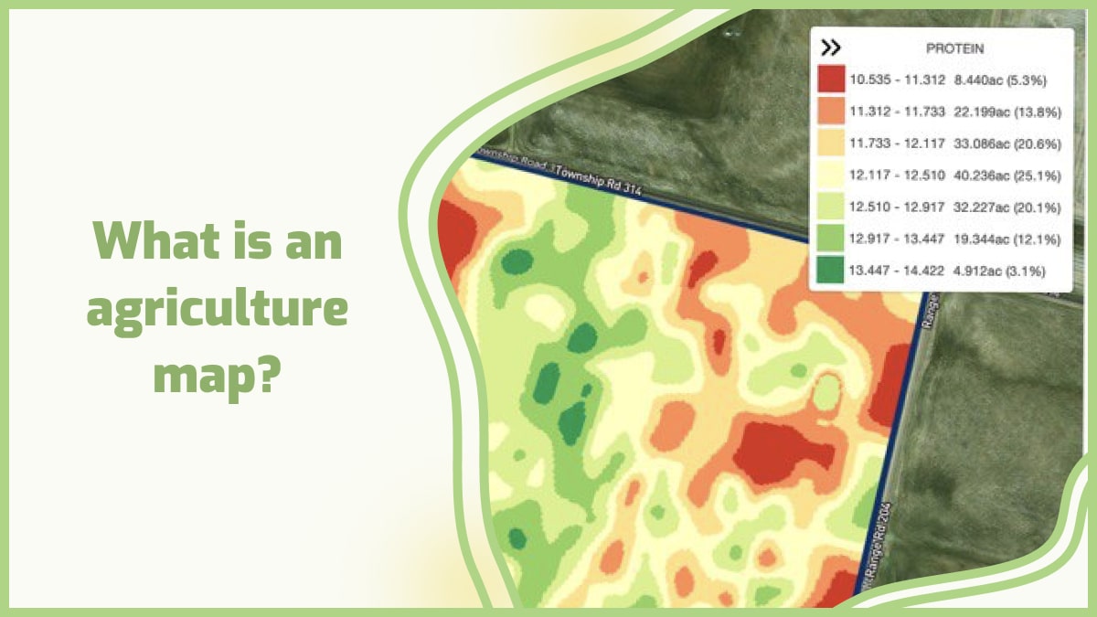
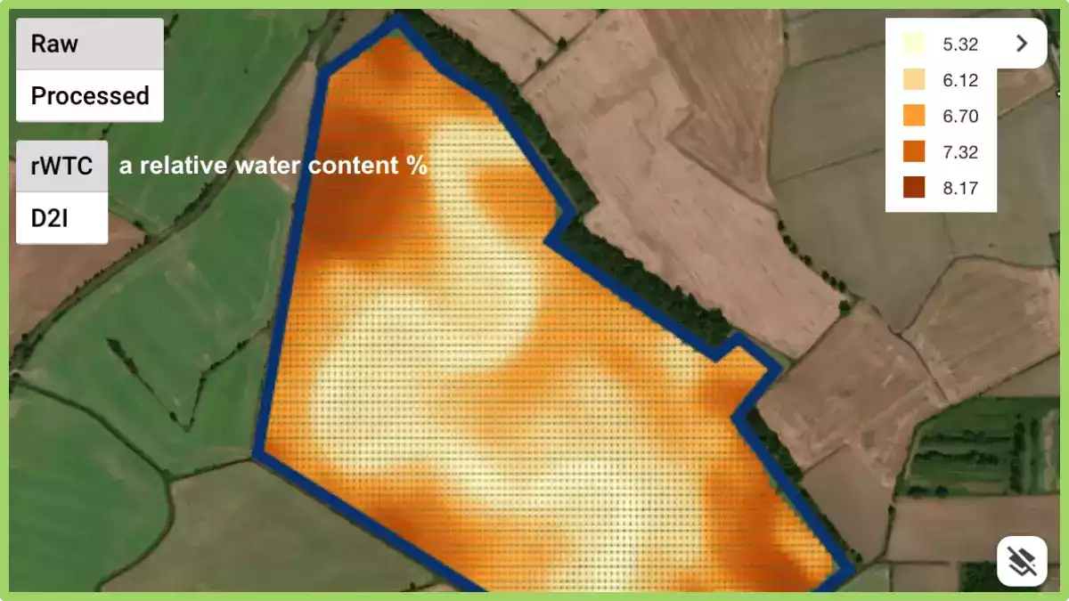
2. Prescription maps for fertilizers, herbicides, and pesticides with drone survey  Just one strategy is out of date, as it not only wastes resources, but it can also affect the health and vitality of crops. Too much water, for example, can kill an otherwise healthy crop by preventing its roots from absorbing oxygen, so even watering isn’t the best approach to growing flawless crops. The same is true for fertilizers; using the correct amount is critical for growth, as using too many causes burnt roots, which can destroy otherwise healthy plants. Drone mapping allows sprays to be splattered only where the problem exists, reducing waste of resources and the risk of harming healthy crops that do not require the same treatment. While humans would be unable to recognize the unique requirements of each plant in their crop, drone survey technology can do it in minutes. 3. Crop assessment At the touch of a button, scouting missions are launched; the drone departs the weatherproof charging station, collects data, and uploads it. The findings of the drone, as well as a study of its plant stress detection and the efficacy of any current treatments or amendments, can be used to adapt automated irrigation systems. With on-site scouting drones, constant health checks are possible. 4. Plant population count With the drone’s powerful AI technology, any variety of plants may be identified. This allows the entire production and total loss to be determined at the start and conclusion of each season, increasing precision and awareness of the growing season’s success. 5. Automatic classifications with drone imaging The drone imaging can tell what type of agricultural land it’s flying over, whether it’s arable, pastoral, or mixed. Drones may count the number of crops and livestock, as shown above, to verify that records are current and that any losses are noted.
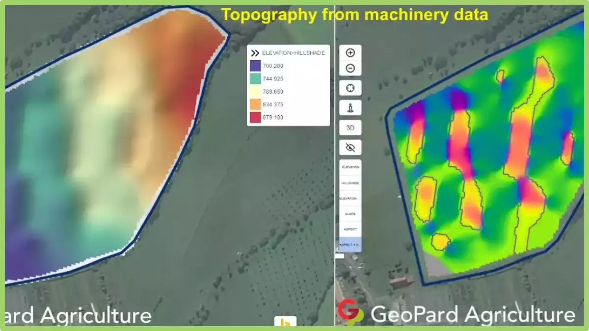
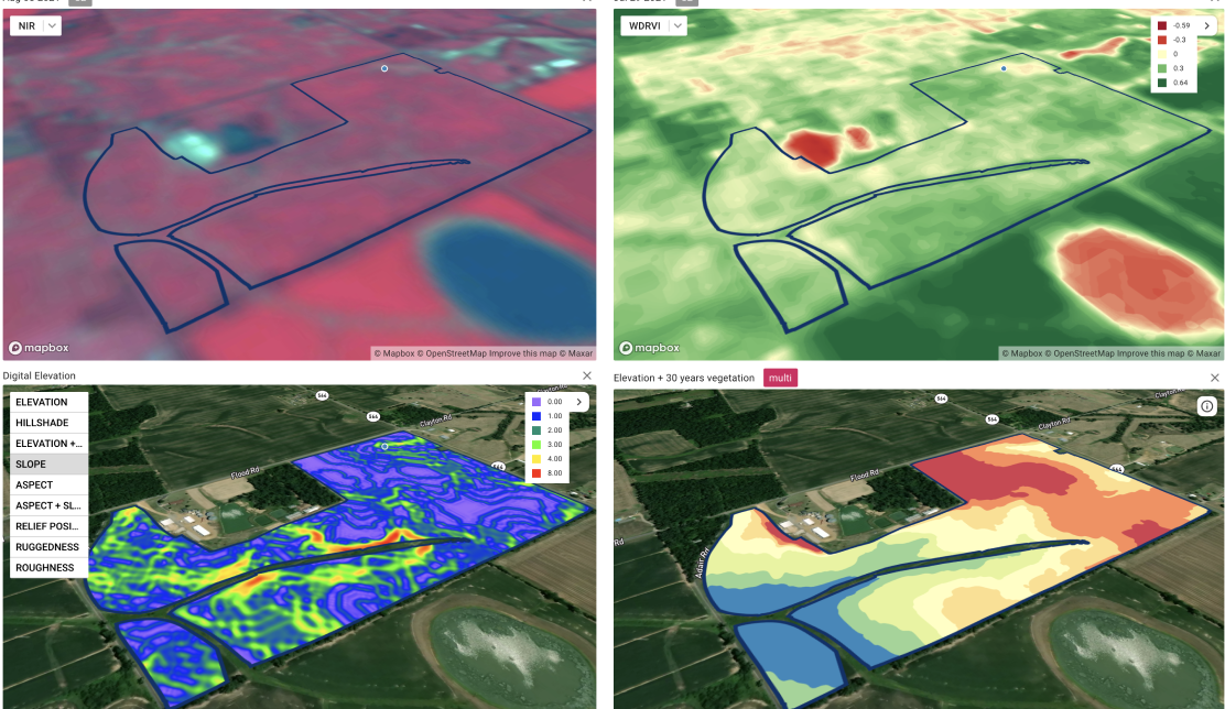
 6. Tracking crops Crop health isn’t predetermined because environmental factors might influence development. Temperature, humidity, nutritional and trace mineral content, insect and disease presence, water availability, and amounts of sun exposure are all elements to consider. All of these may be tracked using the drones’ different payloads, and many of these intangible variables can be handled by applying water or sprays directly to the needed regions. The healthier the crop’s surroundings, the stronger its immune system gets, and thus the healthier it becomes — with a far greater ability to ward off pests and diseases.

How to make a 3d map?

GeoPard can help in creating 3d maps for agricultural aims. It is a unique software that allows you to create your 3D models from any existing geographic data or scratch. GeoPard has all the functions necessary to create 3D maps from satellite images and other sources of aerial photography. The software allows you to classify this data according to different criteria, including color, texture, shape, and height. GeoPard also allows users to control the placement of objects on a map or in an image with great accuracy. This means that users can move objects on a map by simply moving them on their computer screen. The program also comes with integrated tools for editing images and photogrammetry processing features. These features let users do things like changing the scale or orientation of an image or combining multiple images into one large photo. Users can also create new textures by adding details like shadows or noise effects to existing photos. GeoPard can be used by farmers, agronomists, ecologists, geographers, engineers, and all others who need to create 3D maps for agricultural aims. Farmers can use GeoPard to plan crop rotation and fertilization, determine areas with low fertility or high salinity, study soil erosion and landslides, and locate wells and water channels to avoid their contamination by pesticides.

Perguntas frequentes


1. How much area can a drone survey? The area that a drone can survey depends on various factors, including flight time, battery capacity, and regulatory restrictions. Generally, drones can cover several acres of land in a single flight, ranging from a few acres to hundreds of acres. The exact coverage area also depends on the altitude at which the drone is flown and the desired level of detail required for the survey. Advanced drones equipped with longer flight times and larger batteries can cover larger areas in a single flight, while smaller drones may require multiple flights to cover the same area. 2. What season do they fly the drones to analyze the crops? Drones can be flown to analyze crops throughout the growing season, but the timing may vary depending on the specific objectives. Generally, drones are flown during the vegetative stage, flowering stage, and maturation stage of the crops. Each stage provides different insights into crop health, growth patterns, and potential issues. For instance, early-season flights can help assess emergence and uniformity, while mid-season flights can detect nutrient deficiencies or pest infestations. Late-season flights can provide information on yield potential and harvest timing. Therefore, drone flights are conducted at various stages to capture a comprehensive understanding of the crop’s condition. 3. How to make money with a drone in the agriculture industry? There are several ways to make money with a drone in the agriculture industry. One option is to offer aerial imaging and mapping services, providing farmers with detailed aerial data for crop monitoring, field analysis, and yield estimation. Another avenue is to provide crop health assessment services, using specialized sensors to identify issues such as nutrient deficiencies, pest infestations, or irrigation problems. Additionally, offering drone-based spraying services for precision application of fertilizers or pesticides can be lucrative. Lastly, offering drone training and consultancy services to help farmers integrate drones into their operations can also be a profitable venture. 4. How much to charge for drone mapping? The pricing for drone mapping services varies depending on several factors. These include the size and complexity of the area to be mapped, the resolution and level of detail required, and the specific deliverables needed. It is common for drone mapping services to be priced per acre or per hour, with rates typically ranging from $100 to $500 per hour. However, it is best to consult with professional drone mapping service providers to obtain accurate and tailored pricing information for your specific project. 5. What is geomapping? Geomapping, also known as geographic mapping or spatial mapping, is the process of visualizing and representing geographic data on a map. It involves collecting, analyzing, and displaying various types of information such as locations, boundaries, terrain features, and infrastructure. Geomapping allows us to understand and explore relationships between different data points in a spatial context, enabling better decision-making and planning in areas like urban development, environmental management, and navigation. It is a powerful tool used in various fields including cartography, geography, urban planning, and resource management. 6. How to survey land with smartphone? Surveying land with a smartphone can be achieved using various apps and techniques. Firstly, download a reliable surveying app that utilizes the phone’s built-in GPS capabilities. Next, ensure the phone has a stable internet connection and enable location services. With the app open, follow the on-screen instructions to mark specific points, measure distances, and record relevant data. It is important to maintain accuracy by using additional tools like tripods or external GPS receivers if necessary. Always refer to professional surveyors for complex or legal surveying requirements.

How to prepare a usable agriculture map?

Agriculture is a major contributor to our economy, and we need it to stay that way. That’s why it’s important to understand what is happening in the field and how this affects the world. The agriculture industry has been using maps for years to help with growing their crops.

They use them for planning where they will plant their crops, how much of each crop they should plant, and how much money they can make from each crop. When using a farming map, it’s important to understand how to read it and what information it provides.

The map shows different soil types and their fertility levels, as well as different types of vegetation in an area. This type of information can help farmers determine where their fields are located and what kind of crops they should plant there based on soil types and fertility levels.

Also, a good map should be easy to read and understand. It should also be accurate, detailed, and up-to-date.

Here are some tips on how to prepare a usable agriculture map:

1. Use an aerial photograph as the base layer. This will provide a visual reference for other layers and allow for improved accuracy with field boundaries.

2. Create a symbol legend that includes all of the symbols used in the map, along with their meaning. Make sure that all of your symbols are easily identifiable from one another by using different colors, shapes, or patterns.

3. Use clear labeling on any buildings, roads, or other features that need identification. Make sure each label is located directly above its corresponding feature so it’s easy for users to find where they are located on the map.

4. Make sure all text is large enough so it can be read easily from a distance away from the screen or paper printout of your map. This will help avoid any confusion or misreading when someone is trying to interpret what they’re looking at while they’re working in the field or making decisions about their land management practices.

Why do we need an agriculture map?

There are many reasons for this.

1. Farmers need to know where their land is located. They also need to know their boundaries and who their neighbors are. A farmer can use this information to find out if there are any natural resources on their land that might be useful, such as water or minerals.

2. Governments need to know the location of agricultural land so that they can plan public services such as schools and hospitals.

3. Governments want to know how much money comes from farming so they can decide how much they should spend on improving the industry in future years.

4. An agriculture map also allows you to see how your farm compares with other farms in your area and gives you an idea of what kinds of crops may grow well in the area.

5. The use of an agriculture map can help you plan crop rotations and determine which crops will provide the most money for each acre of land that you have available.

What is field mapping in agriculture?

Field mapping is the process of using GPS technology to map out your land. It is used by farmers and agribusinesses as a way to gather information about their fields and crops, such as how much they have grown or how fertile they are.

Field mapping uses real-time GPS technology to make sure that you have accurate information about your land. This is different from traditional surveying methods because it does not require a surveyor or any other person with specific skills in the field of surveying.

Instead, all of the work happens automatically using cameras and sensors on drones or satellites that fly over your property and take pictures of it from above.

Field mapping in agriculture

The software then compares those images with older ones taken when you first purchased the property so that it can calculate how much difference there is between them.

Field maps are usually created using aerial photos or satellite images. The most common types of field maps include:

  • Soil surveys: These maps show the location and type of each soil in an area.
  • Agricultural land use: These maps show which types of crops are grown in an area and how much they produce per acre.
  • Crop rotation: These maps show how often different types of crops are grown in a particular area over time. They can also show which crops are rotated with other crops or which crops are rotated with each other.

There are two main reasons why field mapping is so popular among farmers:

1. It allows them to get an accurate estimate of how much produce can be expected from a certain area of land or crop.
2. Field mapping can help them decide whether or not it would be beneficial for them to invest in particular types of seeds or fertilizers.

Precision agriculture mapping

Precision agriculture mapping is a subset of GIS (geographic information systems) that uses satellite and aerial imagery to map the location of crops and other agricultural features. This information can be used by farmers to determine where they should apply water and fertilizer, which helps them save money and increase their yields.

Precision agriculture maps allow you to see exactly where your crops are growing at their best and worst. You can use this information to assess how much fertilizer you need to use on each section of your farm, as well as how much water or pesticides are needed.

A precision agriculture map shows you exactly where the best and worst soil conditions are located on your farm.

Precision agriculture mapping

Precision agriculture mapping focuses on three major areas:

1. Soil mapping

Soil maps show what types of soil are present in a field or area, as well as their characteristics (such as moisture content). Farmers use this information to determine which crops will grow best in certain areas.

2. Water management

Water is necessary for growing crops, but too much or too little can negatively affect plant growth. Precision agriculture mapping helps farmers determine how much water their fields need based on factors such as slope, soil type, and drainage capacity. This process can help reduce waste from over-fertilizing or overwatering fields.

3. Field data collection

The best way to determine how much water your fields need is by collecting data about each field before planting begins. You can do this by flying drones over each area separately or by driving vehicles through each field multiple times during different times of day/year cycle.

GIS maps for agriculture

GIS maps are becoming increasingly important in the agricultural industry. GIS (Geographic Information Systems) maps allow farmers and agribusinesses to gain a better understanding of their land, crops, and livestock.

GIS maps are used by farmers to make critical decisions about how they use their land. Farmers can use GIS maps to determine where they should farm certain crops, when to plant them, and when to harvest them. With these types of maps, farmers can also make sure that they have enough water for their crops throughout the season.

GIS maps for agriculture can also help you plan for new businesses or products that could improve your bottom line. For example, if you want to make the switch from raising cattle on pastureland to raising them in feedlots, you’ll need GIS maps showing where there are suitable sites for feedlots nearby.

GIS maps are used by agribusinesses to determine where they should place new farms. These businesses can also use GIS maps to determine what types of crops will be profitable in certain areas.

Farmers who want to become more efficient with their farming may want to invest in a GPS or other types of technology that will help them get more out of their land. There are many types of GIS maps for agriculture that are used by farmers and ranchers to manage their operations more effectively and efficiently. These include:

Land use maps – These show where different types of land use exist within an area. This includes forests, grasslands, wetlands, etc. Land use maps can also be used to show where certain crops are grown or livestock is raised regularly so that farmers can make sure they’re using their land effectively and efficiently.

Soil maps – Soil maps show what type of soil is present in an area as well as its characteristics (such as color) and other characteristics (such as pH). These can be used by farmers to determine which crops grow best in certain areas based on the type of soil present there.

GIS maps for agriculture can be used in many ways:

  • To monitor plant growth, crop maturity, and soil conditions as they relate to weather patterns.
  • To keep track of livestock, so you know where they are at all times and whether they need feeding or medical attention.
  • To create maps that show where crops are located on your property, so you can avoid accidentally spraying them with pesticides or herbicides.
  • To show how much water is available around your farm or ranch. You can see whether there are any rivers or lakes nearby that could provide water for your animals during times when there isn’t enough grass available for them to eat in dry months.
  • To reduce expenses and improve crop yields.

How does precision mapping solve agribusiness challenges?

Precision mapping solutions are helping farmers and agribusinesses across the globe to overcome their challenges. From yield monitoring and soil management to precision farming and crop protection, these solutions are enabling growers to increase productivity and optimize resource use.

Precision mapping solutions are helping growers to:

1. Optimize fertilizer use

Farmers can use precision mapping data to improve their fertilizer application rates by identifying areas where nitrogen levels are low, enabling them to make more informed decisions on the best time and method of application.

2. Improve crop protection

Agronomists can use data from precision mapping to identify areas where insect damage is likely to occur, allowing them to better target pest control treatments at locations where they will be most effective.

3. Monitor water distribution

Water managers can use information from precision mapping and soil moisture probes to monitor water distribution across fields or within individual plots, ensuring that crops receive enough water at critical times during growth cycles.

4. Increasing yields

Precision mapping helps farmers increase their yields by making it easier to plant the right seeds at the right time, helping them avoid over-fertilization and under-fertilization problems.

It also makes it easier for farmers to follow their fields’ water needs, so they don’t have to waste time and money watering fields that aren’t ready yet or that already have enough water.

This increases profits because it reduces wasted resources like fuel and fertilizer while improving soil quality by avoiding over-fertilization and maintaining ideal moisture levels at all times.

5. Reducing crop loss

Precision mapping also helps farmers reduce crop loss by making it easier for them to identify potential hazards like pests or disease outbreaks before they happen, so they can take preventative measures before disaster strikes.

6. Improved safety for workers

Using precision mapping technology helps improve the safety of industrial workers by reducing the number of injuries on farms through improved planning and analysis of tasks performed by workers.

7. Improving operational efficiency

Agribusinesses must comply with strict regulations regarding worker safety, environmental impact, and food safety.

Precision mapping can help companies understand how their operations impact the environment, which in turn allows them to make better-informed decisions about where and how they grow crops or raise livestock.

8. Minimizing risk

Precision mapping offers insights into potential risks before they occur. For example, if a farmer knows that flooding is likely due to heavy rainfall or a sudden change in weather patterns, he can use this information to plan accordingly. This allows him to avoid costly damages caused by flooding or other natural disasters.

9. Increasing profitability

With precision mapping’s ability to analyze crop yield over time and compare it with historical data for each field on your farm, you’re able to identify areas that need improvement in your farm thus helping you increase profitability.

Agricultural mapping is a very important thing when it comes to improving the efficiency of the agriculture system. The main reason for this is because it helps farmers identify the areas where they can grow crops or any other product that they need from their farms.

This helps them to improve their source of income from farming and make sure that they have enough resources available so that they can produce more food for consumption for people living in urban areas.

GeoPard has created a platform where farmers can get access to all sorts of information regarding their farms, such as their current condition, crop yield, etc. All this information will be stored on a cloud server where users can access it through smartphones or laptops without having to go out into the fields themselves.

GeoPard is a robust, easy-to-use software product that helps farmers and agribusinesses to collect and process data from their fields. The software has been designed to meet the needs of agricultural professionals working on farms, in fields, and in offices.

GeoPard’s capabilities range from basic field data collection to advanced mapping applications. The software allows you to easily prepare usable agricultural maps with your data layers that show crop type, fertility levels, yield estimates, etc.

It also provides several tools for analyzing soil maps which can be used to identify areas with low fertility or other problems.

Analisar dados do Geoprospectors / TopsoilMapper

GeoPard is capable of processing and analyzing various types of ag spatial data. This is an example of working with high-density sensor datasets with a great spatial variability provided by Geoprospectors GmbH

After importing a data captured by TopsoilMapper, you can see 

  • a relative water content
  • a depth to interface with information about compaction
  • electrical conductivity on 4 cumulative depth
A relative water content, raw points

Geopard lets you see points with raw values and continuous surface; compare different data layers; delineate soil zones for zonal soil sampling and VRA; combine TopsoilMapper data with data available in GeoPard such as historical, current vegetation, and elevation into one Zones Map. 

Compare layers: vegetation (WDRVI), Zones Map (EC+Elevation), EC, Compaction


Curious to know what low EC values represent on the map as a curve? This is an ancient riverbed, buried underground.

Topography based on machinery data

A lot of data collected from the fields is not used by farmers and agronomists. As an example, almost any modern machinery has a GPS receiver which is capable of gathering elevation data, quite often accuracy is improved with Real-time kinematic (RTK). 

Most of this data is not actively used, because it is quite a time consuming to extract, clean, and process this information to acquire real value out of it. One of the GeoPard main idea is to decrease the complexity of data usage in Precision Agriculture. 

GeoPard is capable of automatically extracting high-accuracy elevation data from:

  • Yield datasets
  • EC/other sensors datasets

GeoPard utilized the best available topography dataset for every field, but, unfortunately, high-accuracy lidar data is not available for every location in the world. Therefore, a machinery data-based digital elevation model will be a perfect option and significantly improves knowledge about the field. 

Henceforth, as any data layer in GeoPard, you can create zones out of machinery elevation data with Zones Creator, use this data in the Zones Ops module (finding of overlappings among different datasets) and use it in multi-layer analytics.

Note that it is also possible to compare remote sensing based VS machinery/RTK based topography models.

What are topographic equipment?

Topographic equipment refers to the specialized tools and instruments used in the field of topography, which is the study and mapping of the surface features of the Earth.

What are topographic equipment

These tools are designed to measure and record various aspects of the land’s topography, including elevation, slope, and contours. Here are some commonly used topographic equipment:

  • Total Station: A total station is an electronic surveying instrument that combines the functions of a theodolite (used for measuring horizontal and vertical angles) and an electronic distance meter (EDM) to measure distances. It is used for precise positioning and measuring angles and distances in topographic surveys.
  • GPS (Global Positioning System) Receiver: GPS receivers use signals from satellites to determine accurate positions on Earth’s surface. In topography, GPS receivers are used to establish control points and measure coordinates, which are crucial for creating accurate topographic maps.
  • Leveling Instrument: Leveling instruments, such as a dumpy level or digital level, are used to measure height differences or elevations between different points on the ground. They help in determining contours and slopes of the land.
  • LiDAR (Light Detection and Ranging): LiDAR is a remote sensing technology that uses laser light to measure distances and create detailed three-dimensional maps. It is commonly used in aerial or ground-based surveys to capture high-resolution elevation data.
  • Photogrammetric Equipment: Photogrammetry involves obtaining measurements from photographs. Specialized cameras, topographer machine, drones, or unmanned aerial vehicles (UAVs) equipped with high-resolution cameras are used to capture aerial images. Photogrammetric software is then used to process these images and extract topographic information.
  • Handheld GPS Devices: Handheld GPS devices provide accurate position data in real-time. They are portable and used for navigation, mapping, and data collection in the field.
  • Field Books and Measuring Tools: Field books are used by surveyors to record measurements, sketches, and notes during topographic surveys. Measuring tools like measuring tapes, ranging poles, and flagging tape are used for measuring distances and marking points of interest.

These are some of the essential topographic equipment used in the field. It’s important to note that technological advancements may introduce new tools or variations of existing equipment, so staying updated with the latest developments is recommended.

What is topographer machine?

A topographer machine, also known as a topographic surveying machine or a topographic mapping system, is a specialized tool used in agriculture for the precise measurement and mapping of the physical features of a field or agricultural land.

What is topographer machine in agriculture

It is designed to capture accurate elevation data and create detailed topographic maps that represent the terrain’s contours, slopes, and other essential characteristics.

The topographer machine typically consists of advanced surveying equipment, including Global Positioning System (GPS) receivers, laser scanners, LiDAR (Light Detection and Ranging) sensors, and onboard computers.

These components work together to collect precise location data and measure the elevation of various points across the agricultural land.

The machine is operated by agricultural professionals or trained technicians who deploy it in the field. As the topographer machine moves through the area, it uses GPS signals to determine its position and laser or LiDAR technology to measure the height of the terrain. The collected data is then processed and analyzed to create accurate topographic maps.

The generated topographic maps provide valuable information to farmers and land managers. They allow for better planning and management of agricultural activities, such as irrigation, drainage, and land leveling.

By understanding the topography of the land, farmers can optimize their farming practices, minimize soil erosion, and enhance overall crop productivity.

In conclusion, topographic equipment plays a vital role in accurately measuring and mapping the surface features of the Earth in the field of topography. The information gathered using these tools is crucial for creating detailed topographic maps, which in turn aid in effective land management, planning agricultural activities, and optimizing farming practices. 

wpChatIcon
wpChatIcon

    Solicitar Demonstração / Consulta Gratuita GeoPard


    Ao clicar no botão, você concorda com nossos Política de privacidade. Precisamos disso para responder à sua solicitação.

      Assine


      Ao clicar no botão, você concorda com nossos Política de privacidade

        Envie-nos informações


        Ao clicar no botão, você concorda com nossos Política de privacidade