Tarkkuusmaatalouden tietojen huomiotta jättämisen piilevät kustannukset mittakaavassa

Tarkkuusmaatalouden tietojen huomiotta jättämisen piilevät kustannukset mittakaavassa

Ignoring precision agriculture data on large farms isn’t just risky—it’s costly. When you apply uniform rates across diverse fields, revenue drains quietly without your notice. In this post, you’ll see how unmanaged yield variability and late problem detection chip away at your bottom line. We’ll highlight how management zones and VRA prescriptions can plug these leaks, backed by solid ROI evidence. Ready to see what GeoPard’s data-driven agronomy can do for your operation? Learn more about the economic consequences of neglecting precision agriculture data täällä.

Economic Impact of Precision Ag

Precision agriculture isn’t just a buzzword—it’s a game-changer for profitability. When large farms neglect precision data, they risk losing more than just potential yield. Let’s explore the hidden costs and how you can avoid them.

Revenue Leaks from Uniform Rates

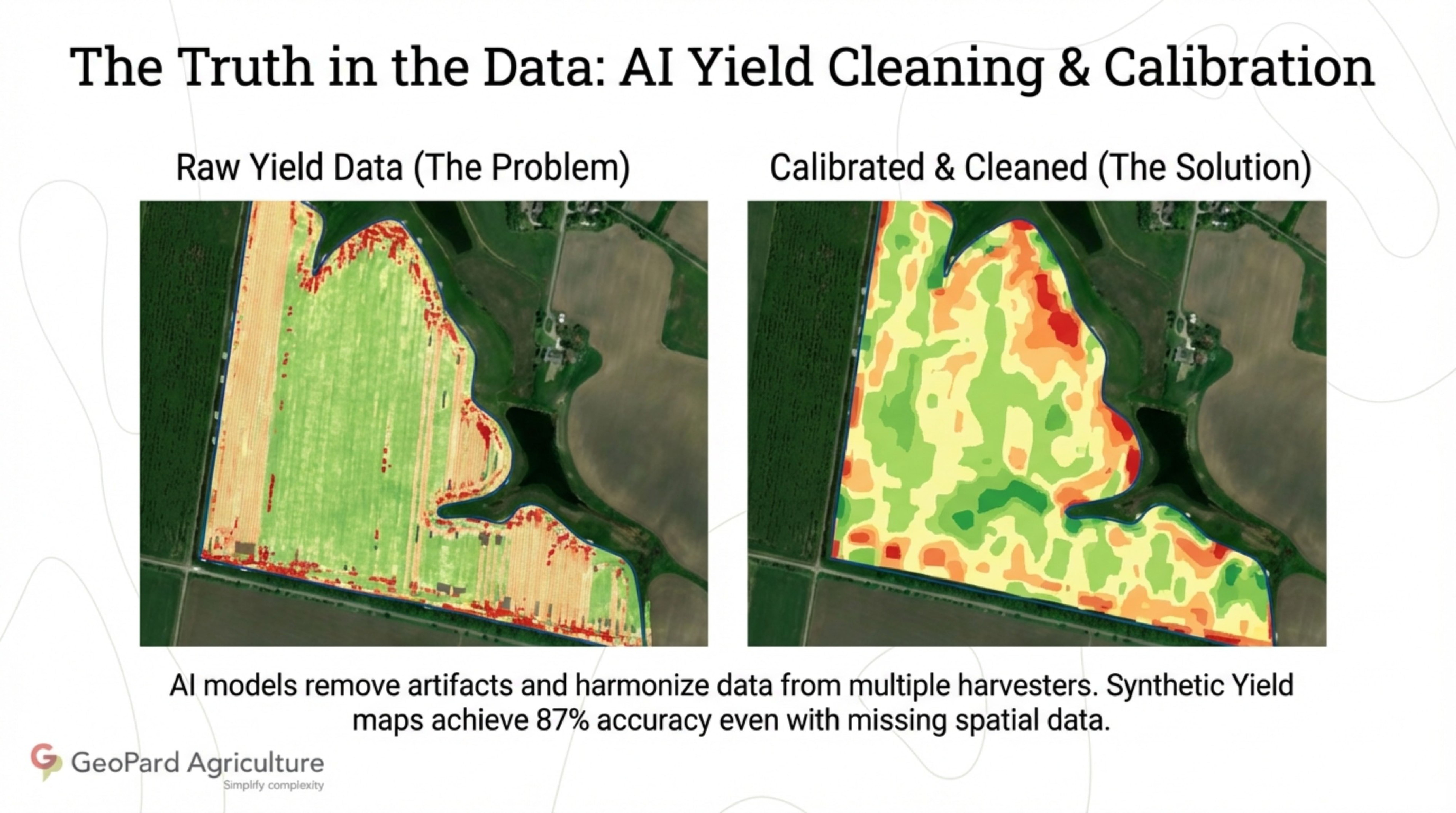
Applying the same treatment across varied fields might seem efficient, but it often results in hidden costs. Why? Because every part of a field is unique. Uniform rates can lead to over-application in some areas, while others suffer from nutrient deficiencies. These overlooked discrepancies can quietly drain revenue. A study found that farms using uniform rates lost up to 20% yield potential due to uneven input distribution. By understanding each field’s needs, you can prevent these leaks.

Consider this scenario: A farmer applied the same amount of fertilizer across a 200-acre field. The result? Some areas thrived, while others underperformed significantly. This inconsistency led to a substantial loss in potential income. Avoiding this pitfall starts with recognizing that no two fields are alike.

Cost of Ignoring Farm Data

Data can be overwhelming, but ignoring it costs more. Imagine missing signs of disease until it has spread, or overlooking soil nutrient changes until yields drop. These situations are more common than you’d think. Ignoring farm data can lead to costly interventions and lost yields. When you don’t monitor critical data, problems go unnoticed until it’s too late. This oversight can mean the difference between profit and loss.

Most people think they can rely on intuition, but data tells a clearer story. For instance, a farm that monitored its soil data saved 15% on fertilizer costs, simply by adjusting applications based on real-time feedback. Data-driven decisions bring more precision into farming practices.

Large-Scale Farming Profitability

For large-scale operations, precision isn’t a luxury—it’s a necessity. With vast areas to manage, efficiency becomes paramount. Large farms face unique challenges, from managing diverse soil types to optimizing input usage across distances. By ignoring precision agriculture data, these challenges multiply, leading to inefficiencies and revenue loss.

Consider the size of your operation: the bigger it is, the more you stand to gain from precision tools. Large farms using precision agriculture data reported up to a 25% increase in overall profitability. The key is consistently applying data insights to guide every decision, from planting to harvesting.

ROI from Zone Management and VRA

Seeing how ignoring precision data can affect your bottom line, let’s shift to solutions. Zone management and Variable Rate Application (VRA) offer promising returns on investment. These strategies tailor inputs to specific field conditions, maximizing efficiency and productivity.

Proven Benefits of Management Zones

Management zones allow you to treat different field areas based on their unique needs. This targeted approach means healthier crops and better yields. Zones can be defined using various data points like soil type, topography, and historical yield. By dividing a field into zones, you ensure each area gets the right amount of care.

A farmer who adopted management zones saw a 30% increase in yield in just one season. This approach not only improved crop health but also reduced input waste. Creating management zones means you’re optimizing every square foot of your field.

Variable Rate Application Prescriptions

Variable Rate Application, or VRA, takes precision a step further by allowing you to apply inputs at rates that match field conditions. Instead of a one-size-fits-all approach, VRA adjusts inputs in real-time. This method reduces waste and boosts efficiency, leading to significant cost savings.

In one case, a farm implemented VRA for nitrogen application and saved 20% on input costs, while maintaining high yield quality. This technique aligns input use with plant needs, ensuring resources are used judiciously. With VRA, you make every drop and grain count.

Precision Ag Tools for Success

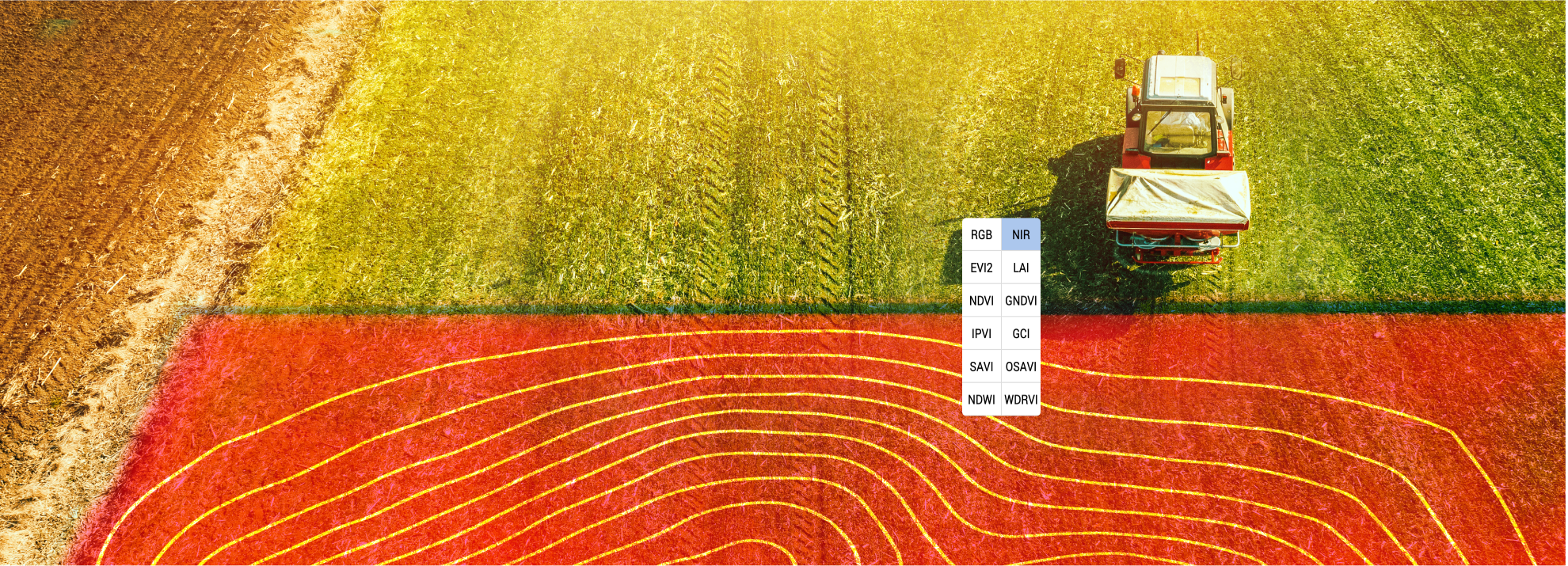
To fully capitalize on precision agriculture, you need the right tools. Let’s dive into how technology, like satellite imagery and crop monitoring software, empowers precision farming.

Satellite Imagery for Farming

Satellite imagery offers a bird’s-eye view of your fields, showing variations you might miss on the ground. This tool helps you spot issues early, such as pest infestations or drought stress. With satellite data, farmers can make timely interventions, preventing small problems from escalating.

Imagine spotting a potential yield drop from space before it affects your harvest. That’s the power of satellite imagery. Many farmers reported catching issues weeks earlier than traditional scouting methods, allowing for more proactive management.

John Deere Operations Center Integration

Integration with tools like the John Deere Operations Center streamlines data management, making it easier to harness precision ag insights. This platform allows for seamless data flow between equipment and field analysis tools. The result? More informed decisions and efficient operations.

By integrating with the John Deere Operations Center, farmers can synchronize their data effortlessly. This connectivity leads to better planning and execution, ultimately enhancing farm productivity.

Crop Monitoring Software Advantages

Crop monitoring software provides real-time insights into crop health, enabling swift action when issues arise. These platforms collect and analyze data on weather patterns, soil moisture, and crop growth. With this information at your fingertips, you can optimize every stage of the growing season.

One farm using crop monitoring software reported a 15% reduction in water usage by tailoring irrigation schedules to actual plant needs. This tool ensures your crops get the care they require, precisely when they need it.

Precision agriculture isn’t just about technology; it’s about using that technology to make smarter decisions. By adopting these tools and strategies, you pave the way for more sustainable and profitable farming.

See the real risks and losses that come from missed data insights in farming.

Tarkkuusymmärryksen väliin jättämisen taloudelliset vaikutukset

Tarkkuusymmärryksen väliin jättämisen taloudelliset vaikutukset

Skipping precision agriculture software is costing you more than you realize. Wasted inputs, unpredictable yields, and overlooked management zones chip away at your profit per acre every season. GeoPard’s farm analytics platform brings all your data together—soil, satellite imagery agriculture, topography analytics—to help you spot inefficiencies and boost agronomic ROI. Keep reading to see how integrating these insights with tools like John Deere Operations Center integration can turn losses into gains. Learn more here.

Ignoring Precision Agriculture Insights

Precision agriculture isn’t just a buzzword; it’s a lifeline for boosting farm profits. Ignoring these insights can lead to significant economic setbacks.

Economic Consequences of Waste

When you don’t use precise data, you waste valuable resources. Many farmers overuse fertilizers and water, thinking more is better. But without precision tools, you might be pouring money down the drain. A recent study showed that farmers could cut input costs by 15% using precision methods. This waste not only affects your pocket but also the environment. See the impact.

Farmers often believe that traditional methods are more reliable. However, without precision software, predicting exact needs becomes guesswork. This leads to over-application, inflating costs unnecessarily. Consider this: a farmer using standard practices might apply 10% more fertilizer than needed, directly impacting profits.

Yield Loss from Data Neglect

Ignoring data means risking lower yields. Without insights, you can’t optimize your fields for maximum output. A farm using GeoPard’s platform saw a 20% increase in yield after integrating topography analytics. Data neglect can lead to missing out on such potential gains.

Farmers who bypass data may also face unexpected crop failures. With precision tools, you can monitor crop health and spot issues early, avoiding drastic losses. Imagine catching a disease outbreak before it spreads, simply by using a crop monitoring tool.

Inefficiencies in Farm Operations

Operational inefficiency is a silent profit killer. Without precision insights, farm operations can become chaotic. You might spend more time and resources fixing problems that could have been prevented. The GeoPard platform helps streamline these processes, making operations smoother and less costly.

A lack of precise management zones often results in uneven growth across fields. This inconsistency can reduce overall yield quality and quantity. By using precision agriculture software, you ensure every part of your field is optimized for growth, reducing waste and increasing profit per acre.

Recovering Lost Profit Per Acre

Now that we’ve seen what ignoring precision insights costs, let’s explore how to recover those lost profits. GeoPard offers the tools you need to make every acre count.

GeoPard’s Analytics Overview

GeoPard’s analytics platform gives you clear, actionable insights. By analyzing data from soil, satellite imagery, and topography, you can make informed decisions. This data-driven approach helps you target problem areas and improve overall efficiency. For instance, using GeoPard, a farm increased its agronomic ROI significantly by identifying and correcting inefficiencies.

With over 20 years of satellite imagery, GeoPard provides historical context to your decisions. This wealth of information allows you to predict trends and prepare accordingly. Imagine having the power to foresee what your fields need and when.

Integrating with John Deere Operations Center

GeoPard seamlessly integrates with John Deere Operations Center. This integration means you can synchronize data between platforms, enhancing your operational efficiency. By combining GeoPard’s insights with John Deere’s tools, you can create a powerhouse of precision farming.

The integration allows for easy transfer of data, ensuring that you never miss a beat. This bi-directional flow of information lets you make real-time adjustments, optimizing every aspect of your farm operations. Explore integration benefits here.

Maximizing ROI with Precision Tools

Precision tools are your best bet for maximizing ROI. GeoPard provides versatile options for creating management zones and variable rate application maps. With these tools, you apply the right amount of inputs exactly where needed, reducing waste and improving yields.

Farmers using precision tools report higher profitability and smoother operations. By leveraging GeoPard’s advanced analytics, you can make data-driven decisions that ensure every dollar spent contributes to your bottom line. The longer you wait, the more opportunities slip away; act now to secure your farm’s future profitability.

In summary, skipping precision agriculture insights is a costly mistake. But with GeoPard, you have the power to turn the tide, reclaiming lost profits and ensuring your farm’s success in the data-driven age of agriculture.

Ymmärrä, mitä tapahtuu, kun kriittistä maatilatietoa ei käytetä.

Tarkkuusmaatalouden datan hallinta: Yleiset haasteet ja niiden voittaminen

Tarkkuusmaatalouden datan hallinta: Yleiset haasteet ja niiden voittaminen

Tarkkuusmaatalouden tiedonhallinnan taltuttaminen tuntuu kuin painisi myrskyn kanssa. Painit sotkuisten satotietojen, hajallaan olevien maaperätietokerrosten ja sotkuisten topografia-analyysien kanssa, jotka hidastavat edistymistäsi. Tässä oppaassa selvitetään nämä yleiset haasteet ja näytetään, miten monimutkaiset tiedot muunnetaan selkeiksi ja käyttökelpoisiksi oivalluksiksi, jotta voit rakentaa täsmällisiä hallintavyöhykkeitä, luoda VRA-karttoja ja kasvattaa ROI:ta luottavaisesti. Lisää tietoa löydät osoitteesta tämä resurssi.

Tarkkuusviljelyn tietohaasteet

Tarkkuusviljely lupaa tehokkuutta ja suurempia satoja, mutta tietojen hallinta voi tuntua ylivoimaiselta. Saatat ajatella, että enemmän tietoa on aina hyvä asia, mutta liiallinen tiedon määrä voi hidastaa toimintaa. Puretaan nämä haasteet ja katsotaan, miten voit voittaa ne.

Tietojen ylikuormituksen ymmärtäminen

Tarkkuusmaatalouden alalla termi “tiedon ylikuormitus” on liiankin tuttu. Kun käytössä on useita eri lähteitä, kuten satelliittikuvia, sadonvalvontalaitteita ja antureita, pelkkä tietomäärä voi lamauttaa päätöksenteon. Kuvittele, että yrittäisit järjestää kirjastoa ilman luettelointijärjestelmää. On tärkeää priorisoida, mitkä tiedot todella vaikuttavat päätöksiin.

Tämän hallitsemiseksi on keskityttävä tietoihin, jotka tarjoavat käyttökelpoisia tietoja. Esimerkiksi historiallinen NDVI-analyysi voi tuoda esiin pelloillesi tärkeimpiä suuntauksia. Rajaamalla painopisteen voit muuttaa tiedon ylikuormituksen virtaviivaistetuiksi toiminnoiksi.

Tietojen epäjohdonmukaisuuksien käsittely

Tietojen epäjohdonmukaisuudet voivat romuttaa parhaatkin suunnitelmat. Tuotantomonitorien ja manuaalisten mittausten välillä voi olla ristiriitaisuuksia, jotka johtavat epäluottamukseen tietoja kohtaan. Epäjohdonmukaisuus johtuu usein laitteiden erilaisista kalibroinneista tai antureihin vaikuttavista ympäristötekijöistä.

Näiden puutteiden korjaaminen edellyttää järjestelmällistä lähestymistapaa. Aloita kalibroimalla laitteesi säännöllisesti tarkkojen lukemien varmistamiseksi. Johdonmukaiset tietojen puhdistuskäytännöt ovat myös olennaisen tärkeitä luotettavien tietokokonaisuuksien ylläpitämisessä. Näin voit palauttaa luottamuksen tiedonhallintaprosessiisi.

Tietojen yhteentoimivuuden tehostaminen

Yhteentoimivuus on merkittävä este tiedonhallinnassa. Eri järjestelmät eivät useinkaan pysty kommunikoimaan tehokkaasti, mikä johtaa tiedon siiloutumiseen ja mahdollisuuksien menettämiseen. Kuvittele, että yrität ratkaista palapeliä, jonka palat ovat peräisin eri sarjoista. Tässä kohtaa saumaton integrointi on välttämätöntä.

Voit voittaa tämän haasteen ottamalla käyttöön alustoja, jotka tukevat yhteentoimivuutta. Esimerkiksi GeoPardin kaltaisten järjestelmien ja John Deere Operations Centerin yhdistäminen voi luoda kaksisuuntaisen tietojen synkronoinnin, joka parantaa yleistä tehokkuutta. Ota käyttöön avoimet standardit varmistaaksesi, että järjestelmät puhuvat samaa kieltä.

Tehokkaan tiedonhallinnan strategiat

Tietojen täyden potentiaalin hyödyntäminen edellyttää käytännön strategioita. Tutustutaan tekniikoihin, joiden avulla voit optimoida tiedonhallinnan jokaisen vaiheen - alkaen satotietojen puhdistamisesta, maaperätietokerrosten integroinnista ja topografian analysoinnista.

Tuottotietojen puhdistustekniikat

Saantotietojen puhdistaminen on ensimmäinen askel kohti luotettavaa tietoa. Likaiset tiedot voivat johtaa epätarkkoihin tuottokarttoihin ja virheelliseen päätöksentekoon. Kuvittele, että yrität lukea karttaa, jonka tarrat ovat tahriintuneet.

  1. Kalibrointi: Varmista, että laitteesi on kalibroitu niin, että ne antavat johdonmukaisia lukemia.

  2. Suodatus: Poista poikkeamat ja kohina, jotta saat selkeän kuvan todellisista tuottokuvioista.

  3. Validointi: Ristiinvertaile tuottotietoja muihin tietokokonaisuuksiin tarkkuuden varmistamiseksi.

Kun tarkennat tietojasi, luot vankan perustan kaikille myöhemmille analyyseille.

Maaperän tietokerrosten integrointi

Maaperätiedot ovat ratkaisevan tärkeitä kenttäolosuhteiden ymmärtämiseksi. Useiden maaperätietokerrosten yhdistäminen voi kuitenkin olla haastavaa. Ajattele, että se on kuin kerrostaisi kakun, jossa on erilaisia koostumuksia ja makuja.

  1. Kerroksen konsolidointi: Yhdistää maaperäantureiden, laboratoriotestien ja historiallisten tietojen tiedot yhtenäiseen muotoon.

  2. Visualisointi: Käytä työkaluja, jotka havainnollistavat maaperän vaihtelevuutta, jotta voit tunnistaa hoitovyöhykkeet tehokkaasti.

  3. Validointi: Vertaa integroituja tietoja todellisten havaintojen kanssa tarkkuuden varmistamiseksi.

Selkeällä lähestymistavalla maaperätiedoista voi tulla tehokas väline hallintastrategiassasi. Lisätietoja maaperätietojen merkityksestä on osoitteessa tämä artikkeli.

Topografian analytiikan hyödyntäminen

Topografian analysointi antaa tietoa pellon vaihteluista, jotka vaikuttavat sadon kasvuun. Korkeuden, kaltevuuden ja kaltevuuden ymmärtäminen voi vaikuttaa merkittävästi pellonhoitostrategioihin, aivan kuten maaston tunteminen ennen vaellukselle lähtöä.

  1. Kartoitus: Hyödynnä topografisia karttoja kentän kaltevuuden ja veden liikkeen ymmärtämiseksi.

  2. Analyysi: Arvioidaan, miten topografia vaikuttaa maaperän kosteuteen ja eroosioriskiin.

  3. Integrointi: Yhdistä pinnanmuodostustiedot muihin muuttujiin kattavien tietojen saamiseksi.

Topografia-analytiikka voi paljastaa piilotettuja mahdollisuuksia ja riskejä pelloillasi. Sukella syvemmälle tähän aiheeseen tämä opas.

Potentiaalin vapauttaminen GeoPardin avulla

GeoPard voi olla liittolaisesi tietohaasteiden selvittämisessä. Sen kattavien työkalujen avulla voit luoda hallintavyöhykkeitä, kehittää VRA-karttoja ja parantaa API-integraatiota saumattoman tiedonkulun varmistamiseksi.

Monikerroksisten hallintavyöhykkeiden rakentaminen

Tehokkaiden hoitovyöhykkeiden luominen on avainasemassa täsmäviljelyssä. Näiden vyöhykkeiden avulla voit räätälöidä tuotantopanoksia, kuten vettä ja ravinteita, pellon erityistarpeiden mukaan.

  • Tietojen integrointi: GeoPard yhdistää eri tietokerroksia muodostaakseen tarkkoja hallintavyöhykkeitä.

  • Mukauttaminen: Säädä vyöhykkeitä reaaliaikaisten tietojen perusteella resurssien käytön optimoimiseksi.

  • Tehokkuus: kohdentaa tuotantopanokset tarkemmin, parantaa satoa ja vähentää hukkaa.

Tehokkaiden VRA-karttojen luominen

VRA-kartat (VRA = Variable Rate Application) ovat ratkaisevan tärkeitä täsmällisen syötteen levityksen kannalta. GeoPardin avulla voit luoda yksityiskohtaisia VRA-karttoja, jotka ohjaavat laitteita resurssien optimaaliseen jakeluun.

  • Reaaliaikaiset päivitykset: Säädä VRA-karttoja nykyisillä tiedoilla tarkkuuden varmistamiseksi.

  • Kustannusten vähentäminen: Käytä panoksia vain siellä, missä niitä tarvitaan, mikä säästää kustannuksia.

  • Tuottojen parantaminen: Paranna sadon suorituskykyä räätälöidyillä tuotantopanoksilla.

API-integraation parantaminen AgTech-yrityksille

Integrointi on elintärkeää sujuvan työnkulun kannalta. GeoPardin API-ominaisuudet mahdollistavat saumattoman tiedonvaihdon muiden AgTech-alustojen kanssa, mikä lisää yleistä tehokkuutta.

  • Joustavuus: Yhdistä olemassa oleviin järjestelmiin virtaviivaista toimintaa varten.

  • Skaalautuvuus: Integroi helposti uusia teknologioita tarpeidesi kasvaessa.

  • Tiedonkulku: Varmista jatkuva tiedonvaihto reaaliaikaisia näkemyksiä varten.

Ottamalla käyttöön nämä strategiat ja työkalut voit muuttaa tietohaasteet mahdollisuuksiksi ja vapauttaa täsmämaatalouden täyden potentiaalin.

Tunnista suurimmat täsmäviljelyn haasteet ja aloita ratkaisujen kehittäminen.

Miten integroitu maatilan tietojen analytiikka parantaa maataloutta koskevia päätöksiä?

Miten integroitu maatilan tietojen analytiikka parantaa maataloutta koskevia päätöksiä?

You spend hours juggling soil tests, yield maps, satellite images, and machine data—yet your agronomic decisions still feel like guesses. Integrating farm data into one platform changes everything. With GeoPard Agriculture, you get AI powered analytics that turn scattered information into clear management zones and precise VRA maps. Keep reading to see how this unified approach sharpens your agronomic decision making and boosts your ROI. https://www.morningagclips.com/agriculture-data-analytics/

The Power of Integrated Farm Data

Harnessing the full spectrum of farm data can transform your approach to agriculture. Let’s dive into how combining different data types can improve decision-making on the farm.

Yield Data Analysis Insights

Understanding your yield data is crucial. It tells the story of your farm’s productivity. With detailed analysis, you can spot patterns and identify areas for improvement. Imagine knowing exactly which parts of your field yield best. This is the power of using analytics to break down your yield data. You can boost output where it’s needed most and reduce input where it’s not. By focusing on yield data, you can make informed decisions that directly impact your bottom line.

Soil Test Mapping Techniques

Soil is the foundation of any farm. Knowing its composition and health is vital. Soil test mapping lets you visualize nutrient levels across your fields. This helps in applying the right amount of fertilizer in the right places. By mapping soil quality, you can avoid wasting resources on areas that don’t need them. This precision saves money and supports healthier crops.

Topography and Satellite Imagery Analytics

The lay of the land affects water flow and nutrient distribution. Topography analytics provide insights into these factors. Coupled with satellite imagery, you get a bird’s-eye view of your fields. Satellite data shows changes over time, revealing trends not visible at ground level. This information helps in planning irrigation and preventing erosion, enhancing farm efficiency.

Enhancing Agronomic Decision Making

When you integrate various data sources, your agronomic decisions become more strategic. Let’s explore how this integration can refine your farming practices.

Creating Stable Management Zones

Stable management zones are the key to efficient farming. These zones are areas within a field that respond similarly to management practices. By establishing these zones, you can tailor your approach to each one. This means applying inputs like water and fertilizer more accurately. Stable zones lead to consistent results, reducing guesswork and enhancing productivity.

Variable Rate Application Maps Explained

Variable Rate Application (VRA) maps are a game-changer. They allow you to apply inputs such as seeds and fertilizers precisely where needed. VRA maps are created using data from soil tests, yield data, and topography. This precision ensures that each part of your field gets exactly what it needs. The result is less waste and better crop performance.

Benefits of AI Powered Analytics

AI transforms raw data into actionable insights. With AI, you can process complex datasets quickly and accurately. This technology identifies trends and anomalies you might miss. By leveraging AI, you optimize every decision, from planting to harvesting. The longer you wait to adopt AI, the more opportunities you miss to improve efficiency and boost ROI.

GeoPard Agriculture: Your Agtech Solution

GeoPard Agriculture offers a comprehensive platform that unifies all these capabilities. Let’s see how it supports your farming operations.

John Deere Operations Center Integration

GeoPard integrates seamlessly with John Deere Operations Center, enhancing your existing system. This integration allows for easy data flow between platforms. Your machinery data combines with GeoPard’s analytics for a complete picture of your farm’s performance. This synergy streamlines operations and improves decision-making.

ROI Analysis in Agriculture

Understanding your return on investment is crucial. GeoPard provides tools to analyze ROI across different farm operations. By examining inputs and outputs, you can identify areas to cut costs and maximize profits. This analysis is essential for long-term farm sustainability.

Start Your Free Trial Today

GeoPard Agriculture empowers you to make data-driven decisions with confidence. Unlock the potential of your fields by trying GeoPard today. With access to advanced analytics and integration capabilities, you streamline your farming operations and elevate your agronomic decision-making. Don’t wait—start your free trial now and take the first step towards precision agriculture.

Tunnista suurimmat täsmäviljelyn haasteet ja aloita ratkaisujen kehittäminen.

Suunnittele, sovella, analysoi: GeoPardin käyttötapaukset VRA:n ja kauden jälkeisen ROI:n kannalta.

Suunnittele, sovella, analysoi: GeoPardin käyttötapaukset VRA:n ja kauden jälkeisen ROI:n kannalta.

Most precision agriculture tools stop short when it comes to linking pre-season planning with post-season results. You need a platform that ties your management zones and VRA maps directly to yield and ROI analysis. GeoPard Agriculture does exactly that—combining soil, satellite, and machinery data so you can plan smarter, apply precisely, and measure returns with confidence. Let’s explore workflows that put your data to work all season long. For more insights, visit our field potential and yield data analysis page.

GeoPard for Agronomic Planning

GeoPard Field Potential maps vs Yield data

GeoPard Field Potential is your start into Precision Agriculture

Stepping into the world of agronomic planning, GeoPard offers more than just data. It turns your field insights into actionable strategies.

Crafting Management Zones

Creating management zones is crucial. With GeoPard, you can use varied data layers to draw precise zones. This means you can focus your resources exactly where they’re needed. For example, using soil type and crop health data, you’ll know precisely where to increase or reduce inputs. This way, not only do you save costs, but you also boost productivity.

Imagine a farmer using satellite and soil data to craft zones. They notice a patch needing more nutrients. With GeoPard, they adjust their plan, apply the right amount, and watch the crops thrive. This precise application is how you turn data into yield. Want to learn more about creating management zones? Check out our detailed guide.

Precision Agriculture Software Tools

GeoPard’s tools offer more than just data aggregation. They provide a comprehensive look at your farm’s health. From satellite images to soil tests, you have everything at your fingertips. These tools help you plan efficiently, ensuring every seed, drop of water, and ounce of fertilizer is used wisely.

Consider the impact: A user can reduce input wastage by up to 30%. That’s real savings and real impact on your bottom line. Plus, you’re helping the environment by minimizing runoff and over-application. Ready for the next step? Explore how these tools can revolutionize your farm management in our software tools overview.

In-Season Monitoring with GeoPard

Once your plan is in place, in-season monitoring helps ensure everything stays on track. GeoPard offers intuitive tools for real-time insights.

Leveraging NDVI Satellite Imagery

NDVI satellite imagery is a game-changer. By assessing vegetation health, you can spot issues before they become costly problems. Picture this: you notice a field section with declining NDVI values. With GeoPard, you identify a pest issue and address it promptly, saving your crop.

These images update every few days, providing fresh insights into your fields. This frequency means you’re never in the dark about what’s happening on your farm. By staying informed, you make timely decisions that can save you money and maximize yield. For more on NDVI, dive into our satellite monitoring tutorials.

Crop Monitoring with Yield Data

Monitoring doesn’t stop with satellites. Tuottotiedot offers another layer of insight. Use it to track performance and make adjustments. Imagine discovering a particular seed variety outperforms others. You can pivot your strategy to focus on what works best.

With GeoPard, you can compare yields year-on-year, identifying long-term trends and making informed decisions. This level of detail is what sets successful farms apart. Curious about maximizing yield data? Visit our analytics tutorials.

Post-Season ROI Analysis

Finally, post-season analysis ties everything together. It’s where strategy meets results, and GeoPard excels in delivering clear insights.

Examining Variable Rate Applications

Evaluating your variable rate applications (VRA) helps you understand what worked and what didn’t. GeoPard provides detailed maps and reports to review application efficiency. Did varying fertilizer rates impact yield as expected? You’ll have the data to know for sure.

This analysis is not just about learning; it’s about growing better next season. By understanding the impact of your VRA decisions, you enhance future outcomes. To see how others have benefited, check out this VRA use case.

Integrating John Deere Operations Center

GeoPard’s integration with the John Deere Operations Center offers seamless data flow. This integration means you can access all your farm data in one place, simplifying management tasks. Picture managing your operations with ease, thanks to synchronized data.

The integration supports data-driven decisions, improving efficiency and boosting your ROI. With everything connected, you’re better equipped to handle challenges and seize opportunities. Learn more about this powerful integration in our John Deere Operations Center overview.

By leveraging GeoPard’s comprehensive suite of tools, you transform your approach to farming. From planning to post-season analysis, each stage is enhanced, ensuring you get the most from your fields. Don’t wait to maximize your farm’s potential—start using GeoPard today!

Learn how precise data can reveal your farm’s hidden challenges.

wpChatIcon
wpChatIcon

    Pyydä ilmainen GeoPard-demo / konsultaatio


    Hyväksymällä painikkeen painamisen hyväksyt meidän Tietosuojaseloste. Tarvitsemme sen vastataksemme pyyntöösi.

      Tilaa


      Hyväksymällä painikkeen painamisen hyväksyt meidän Tietosuojaseloste

        Lähettäkää meille tietoa


        Hyväksymällä painikkeen painamisen hyväksyt meidän Tietosuojaseloste