High-Accuracy AI Models Classifies Topographic Mapping Faster Than Traditional

Indonesia, a nation of over 17,000 islands spanning 1.9 million square kilometers, faces a critical challenge in creating detailed maps to support its development goals.

With only 3% of the country covered by large-scale topographic maps (1:5000 scale), traditional methods like manual stereo-plotting and field surveys are too slow to meet urgent needs for urban planning, disaster management, and environmental conservation.

A groundbreaking study published in Remote Sensing in 2025 offers a solution: a deep learning framework that automates land cover classification using very-high-resolution satellite imagery.

The Challenge of Mapping Indonesia’s Topography

Indonesia’s size and complexity make mapping a monumental task. The Geospatial Information Agency (BIG), responsible for national mapping, currently produces 13,000 square kilometers of topographic maps annually.

At this rate, mapping the entire country would take over a century. Even if forested areas—which cover nearly half of Indonesia—are excluded, completing the remaining terrain would still require 60 years.

This slow progress clashes with national priorities like the One Map Policy, introduced in 2016 to standardize maps across sectors and avoid conflicts in land use. Scaling this policy to 1:5000 maps is essential but far behind schedule.

Topographic maps are detailed representations of natural and human-made features on Earth’s surface, including elevation (hills, valleys), water bodies, roads, buildings, and vegetation.

They serve as foundational tools for infrastructure planning, disaster response, and environmental monitoring. For Indonesia, creating these maps at a 1:5000 scale (where 1 cm on the map equals 50 meters on the ground) is critical for precision in projects like road construction or flood modeling.

The Challenge of Mapping Indonesia’s Topography

Land cover data, a subset of topographic maps, refers to the physical material on Earth’s surface, such as forests, urban areas, or water. Unlike land use (which describes how humans utilize the land, e.g., residential or industrial zones), land focus on observable features.

Accurate land cover maps help governments track deforestation, monitor urban sprawl, or assess agricultural productivity. Traditionally, analysts manually label these features pixel by pixel using aerial photos or satellite images, a process that is both time-consuming and prone to human error.

For example, identifying roads or small buildings in dense urban areas can take days of meticulous work. The 2025 study addresses this bottleneck by replacing manual efforts with artificial intelligence, specifically deep learning, to automate land cover classification.

AI-Driven Satellite Imagery Analysis 

The research focused on Mataram City, a small but diverse urban area on Lombok Island, as a test case. The team used Pleiades satellite imagery from 2015, which included high-resolution panchromatic (0.5 meters) and multispectral (2 meters) data.

Panchromatic images capture fine spatial details in grayscale, while multispectral images provide color and infrared information across specific wavelength ranges (e.g., red, green, blue, near-infrared).

To combine these strengths, the researchers applied a technique called pan-sharpening, which merges the high-resolution grayscale data with lower-resolution color imagery. This process produced crisp, detailed images with a resolution of 0.5 meters, ideal for detecting small features like roads or individual buildings.

Pan-sharpening is vital because it retains the rich spectral information of multispectral data while enhancing spatial clarity, ensuring that colors align accurately with physical features.

Next, the team extracted additional information from the images to improve classification accuracy. They calculated the Normalized Difference Vegetation Index (NDVI), a measure of plant health derived from near-infrared (NIR) and red light reflection.

Healthy vegetation reflects more near-infrared light and absorbs more red light due to chlorophyll activity. The formula NDVI=(NIR−Red)/(NIR+Red) produces values between -1 and 1, where higher values indicate denser, healthier vegetation.

NDVI is invaluable for distinguishing forests, farmland, and urban green spaces. For instance, in this study, NDVI helped differentiate between lush plantations and bare soil.

Texture analysis was another key step. Using a statistical method called the Gray-Level Co-occurrence Matrix (GLCM), the researchers quantified patterns in the imagery, such as the roughness of agricultural fields versus the smoothness of paved roads.

GLCM works by analyzing how often pairs of pixels with specific values and spatial relationships (e.g., horizontally adjacent) occur in an image. From this matrix, metrics like homogeneity (uniformity of pixel values), contrast (local intensity variations), and entropy (randomness of pixel distribution) are calculated.

These texture metrics helped the AI model differentiate between similar-looking land cover types—for example, distinguishing between asphalt roads and dark soil patches.

To simplify the data, the team applied Principal Component Analysis (PCA), a technique that identifies the most significant patterns in a dataset. PCA reduces redundancy by transforming correlated variables (e.g., multiple texture bands) into a smaller set of uncorrelated components.

In this study, PCA condensed five texture bands into two principal components while retaining 95% of the original information. This streamlined the input for the deep learning model, improving both accuracy and computational efficiency.

U-Net Deep Learning for Land Cover Topography

The heart of the study was a deep learning model based on the U-Net architecture, a type of convolutional neural network (CNN) widely used in image segmentation tasks.

Named for its U-shaped design, U-Net consists of two main parts: an encoder that analyzes the image to extract hierarchical features (e.g., edges, textures) and a decoder that reconstructs the image with pixel-wise labels.

The encoder uses convolutional layers and pooling to downsample the image, capturing broad patterns, while the decoder upsamples the data to restore spatial resolution. Skip connections between encoder and decoder layers preserve fine details, enabling precise boundary detection—a critical feature for mapping narrow roads or irregularly shaped buildings.

Distribution of Land Cover Classes in Dataset

The model used a ResNet34 backbone—a pre-trained network renowned for its depth and efficiency. ResNet34 belongs to the residual network family, which introduces “shortcut connections” to bypass layers, mitigating the vanishing gradient problem (where deep networks struggle to learn due to diminishing updates during training).

By leveraging ResNet34’s ability to recognize complex patterns from ImageNet (a massive image database), the model required less training data and time to adapt to satellite imagery.

Training the model required 1,440 image tiles, each 512×512 pixels, covering six land cover classes: buildings, roads, agricultural land, bare land, plantations, and water bodies.

The dataset had inherent imbalances; roads and water bodies made up just 3.7% and 4.2% of the samples, respectively, while buildings and agricultural land accounted for over 25% each. Despite this challenge, the model was trained over 200 epochs—a balance between accuracy and computational cost—with a batch size of 2 due to memory constraints.

An epoch refers to one complete pass of the training data through the model, while batch size determines how many samples are processed before updating the model’s parameters. Smaller batch sizes reduce memory usage but may slow training.

Enhancing Maps with Morphological Processing

Even the best AI models produce errors, such as misclassifying isolated pixels or creating jagged edges around features. To address this, the researchers applied morphological processing, a technique that smooths out imperfections using operations like erosion and dilation.

Erosion removes thin layers of pixels from object boundaries, eliminating tiny misclassified patches, while dilation adds pixels to expand object boundaries, filling gaps in linear features like roads.

These operations rely on a structuring element (a small matrix) that slides over the image to modify pixel values. The optimal kernel size for these operations (5×5 pixels) was determined through semi-variance analysis, a geostatistical method that quantified spatial patterns in the imagery.

Semi-variance measures how much pixel values differ at varying distances, helping identify the scale at which texture features (e.g., building clusters) are most distinct.

AI Boosts Mapping Speed and Accuracy

The model achieved an initial accuracy of 84% (kappa score = 0.79), which rose to 86% (kappa = 0.81) after post-processing. The kappa score (Cohen’s kappa) measures agreement between predicted and actual classifications, adjusting for random chance.

A score of 0.81 indicates “almost perfect” agreement, surpassing the 0.61–0.80 range considered “substantial.” Water bodies and plantations were classified with near-perfect accuracy (97% and 96%, respectively), while roads—challenged by their thin, linear shape and shadows—reached 85%.

AI Boosts Mapping Speed and Accuracy

Buildings and agricultural land also performed well, with F1-scores of 88% and 83%. The F1-score, a harmonic mean of precision and recall, balances false positives and false negatives, making it ideal for evaluating imbalanced datasets.

The efficiency gains were even more striking. Traditional stereo-plotting, which involves manually labeling features in 3D aerial imagery, takes nine days per map sheet (5.29 km²) for buildings and vegetation.

The AI-driven approach reduced this to 43 minutes per sheet—a 250-fold improvement. Training the model required 17 hours initially, but once trained, it could classify vast areas with minimal human intervention. Scaling this system could allow Indonesia to map 9,000 km² annually, cutting the projected completion time from over a century to just 15 years.

AI Mapping Advances Global Sustainability

The implications extend far beyond Indonesia. Automated land cover classification supports global efforts like the UN Sustainable Development Goals (SDGs). For instance, tracking deforestation (SDG 15) or urban expansion (SDG 11) becomes faster and more precise.

In disaster-prone regions, such as flood-prone areas, up-to-date maps can identify vulnerable communities and plan evacuation routes.

Farmers also benefit; accurate land cover data enables precision agriculture, optimizing water use and crop yields by monitoring soil health and vegetation stress via NDVI.

However, challenges remain. The model’s performance on underrepresented classes like roads highlights the need for balanced training data. Future work could incorporate transfer learning, a technique where a model pre-trained on one task (e.g., general image recognition) is fine-tuned for a specific application (e.g., road detection in satellite imagery).

This reduces the need for massive labeled datasets, which are costly to create. Testing advanced architectures like U-Net3+, which enhances feature aggregation across scales, or transformer-based models (which excel at capturing long-range dependencies in images) could further improve accuracy.

However, integrating Lidar (Light Detection and Ranging) or radar data could also enhance results, especially in cloudy regions where optical satellites struggle.

Conclusion: A New Era for Geospatial Science

This study marks a turning point in topographic mapping. By automating land cover classification, countries can produce accurate maps faster and cheaper than ever before. For Indonesia, this technology is not just a convenience—it’s a necessity to manage its rapid urbanization, protect its forests, and prepare for climate-related disasters.

As AI and satellite technology advance, the vision of real-time, high-resolution mapping is within reach, empowering governments and communities to build a more sustainable future.

Reference: Hakim, Y.F.; Tsai, F. Deep Learning-Based Land Cover Extraction from Very-High-Resolution Satellite Imagery for Assisting Large-Scale Topographic Map Production. Remote Sens. 2025, 17, 473. https://doi.org/10.3390/rs17030473

The Secrets Behind Mastering Three-Dimensional Contour Maps

Three-dimensional contour maps are more than just lines on paper—they are gateways to understanding the shape of our world. These maps, which use curved lines to represent elevation, challenge us to imagine hills, valleys, and slopes in three dimensions.

For many, this skill feels intuitive, but for others, it requires careful practice. A 1998 study by Margaret Lanca explored how people mentally convert flat contour maps into vivid 3D landscapes, while also investigating whether men and women approach this task differently.

Recent advancements in technology and psychology have expanded our understanding of these processes, offering new insights into how we learn and remember terrain.

The Challenge of Reading Contour Maps

Contour maps are 2D diagrams that use lines (contours) to represent elevation. Each line corresponds to a specific height above sea level, and the spacing between lines indicates the steepness of a slope. For example, tightly packed lines suggest a cliff, while widely spaced lines represent flat terrain.

These maps are essential in fields like geography, geology, and urban planning because they provide a compact way to visualize complex landscapes.

However, interpreting them requires terrain visualization, the ability to mentally reconstruct a 3D model of the land from 2D lines.

The Challenge of Reading Contour Maps

Imagine looking at a series of concentric circles on paper and picturing them as a hill or a crater. This mental leap is not easy, and researchers have long debated how people achieve it.

Some argue that forming a 3D mental image is essential for accurate map reading. This process, often called spatial processing, involves mentally rotating or “slicing” the map to infer cross-sectional views of the terrain.

Others believe verbal-analytical strategies—such as memorizing labels (e.g., “peak” or “valley”) or analyzing slope angles step-by-step—can work just as well. Lanca’s study aimed to resolve this debate while also exploring gender differences in strategy use.

Science Behind Three-Dimensional Contour Map Interpretation

Three-Dimensional Contour Maps begin as 2D diagrams using lines (contours) to represent elevation. Each line corresponds to a specific height, with spacing indicating slope steepness.

Translating these 2D lines into a mental 3D landscape—Three-Dimensional Contour Map Visualization—is a complex cognitive skill.

Learners often struggle with this process, as it requires spatial reasoning to infer hills, valleys, and slopes from abstract lines. Prior research debated two strategies:

  1. Spatial Processing: Mentally rotating or “slicing” the map to construct a 3D model.
  2. Verbal-Analytical Processing: Using labels, step-by-step analysis, or mnemonics.

Lanca’s study sought to resolve whether Three-Dimensional Contour Map Visualization is essential for accuracy or if verbal strategies suffice. She also examined gender differences, given men’s historical edge in spatial tasks like mental rotation.

How the Study Was Conducted

Lanca recruited 80 participants—40 men and 40 women—from the University of Western Ontario. None had prior experience with contour maps, ensuring that the results reflected genuine learning rather than existing knowledge. The participants were divided into four groups.

  1. Contour → Contour: Studied 2D maps, recognized 2D maps.
  2. Contour → Landsurface: Studied 2D maps, recognized 3D landsurface maps.
  3. Landsurface → Landsurface: Studied 3D maps, recognized 3D maps.
  4. Landsurface → Contour: Studied 3D maps, recognized 2D maps.

The first group studied traditional 2D contour maps and later took a recognition test with the same type of maps. The second group studied 2D contour maps but were tested on 3D drawings called landsurface maps, which show terrain in a more visual, realistic style.

Map Study and Recognition Groupings

The third group studied landsurface maps and were tested on the same format, while the fourth group studied landsurface maps and were tested on 2D contour maps. Each participant completed two tasks.

First, they took a cross-section test. After studying a map for 40 seconds, they answered questions about the terrain’s profile along specific lines. For example, they might be shown three cross-sectional diagrams and asked which one matched a line drawn across the map.

Second, they took an incidental recognition test, where they viewed pairs of maps—one they had studied and one new—and identified the familiar one.

Reaction times and accuracy were recorded for both tasks. Afterward, participants described the strategies they used, such as mentally rotating the map or memorizing labels.

3D Visualization in Contour Map Findings

The results revealed clear patterns. Participants who studied 3D landsurface maps performed better on the cross-section test, scoring an average of 58% accuracy compared to 45% for those who studied 2D contour maps. This suggests that 3D visuals make it easier to infer the shape of the terrain.

However, reaction times were similar for both groups—around 10 seconds per question—indicating that once a map was understood, answering questions took the same effort regardless of format.

Gender differences emerged in the recognition tests. Men outperformed women when tested on the same format they had studied.

  • Contour → Landsurface Group: Men scored 62.5% (SD = 8.1) vs. women’s 47.5% (SD = 9.7).
  • Contour → Contour Group: Men recognized 84.2% (SD = 10.7) of maps vs. women’s 73.3% (SD = 17.5).

For example, men who studied 2D contour maps recognized 84% of them later, compared to 73% for women. Men also excelled when tested on 3D landsurface maps after studying 2D contour maps, scoring 63% accuracy versus 48% for women.

These differences suggest that men relied more on spatial processing, building 3D mental images, while women used verbal or analytical strategies. Post-test reports supported this: men described “imagining the entire hill and rotating it,” while women focused on “counting contour lines” or “naming valleys.”

Long-term memory also favored 3D processing. Men who used spatial strategies showed stronger recognition of maps they had answered correctly in the cross-section test.

For example, they recognized 74% of landsurface maps linked to correct cross-section answers, compared to 52% for incorrect ones. Women, however, showed no such difference, implying their strategies—while effective for the test—did not create lasting mental models.

Recent Advancements in Spatial Cognition and Technology

Since Lanca’s study, new research has deepened our understanding of how people visualize 3D maps. For instance, a 2021 meta-analysis confirmed that spatial skills can be improved with practice, reducing gender gaps.

Women who trained for 10 hours on mental rotation tasks improved their accuracy by 30–40%, showing that these skills are not fixed. Modern tools like virtual reality (VR) and augmented reality (AR) have also transformed map learning.

Recent Advancements in Spatial Cognition and Technology

A 2022 study found that students using VR to “walk through” terrain scored 65% higher on tests than those using traditional 2D maps. These tools allow users to interact with 3D landscapes, making abstract concepts like elevation and slope more tangible.

Advancements in artificial intelligence (AI) have further changed the field. Programs like Esri’s ArcGIS Pro now generate 3D terrain models from 2D contour maps in seconds, helping professionals predict flood risks or plan infrastructure without relying solely on manual visualization.

Brain imaging studies, such as a 2020 project using fMRI scans, have shown that spatial processing activates areas of the brain linked to spatial awareness, while verbal strategies engage regions associated with language. This aligns with Lanca’s findings that men and women often use different parts of the brain for the same task.

Gender Differences in Map Reading Strategies

The gender differences observed in Lanca’s study align with broader research on spatial cognition. Men often excel in tasks requiring mental rotation, such as imagining how an object looks when turned sideways.

This skill is closely tied to 3D visualization, which explains their advantage in recognizing maps. Women, on the other hand, tend to use verbal-analytical strategies, breaking down problems into smaller steps or relying on labels.

Both approaches worked for the cross-section test, but spatial processing gave men an edge in long-term memory. These differences are not about ability but about strategy.

For instance, a woman might excel at remembering the names of landmarks on a map, while a man might better recall the overall shape of a hill.

This has important implications for education and training. If instructors focus only on one method—say, spatial visualization—they might overlook students who thrive with verbal or analytical techniques.

Gender Differences in Map Reading Strategies

These differences are not about ability but about cognitive style, or preferred ways of thinking. However, they have real-world implications. A 2023 report found that women make up only 28% of the workforce in fields like geology and cartography, which rely heavily on spatial skills.

Organizations like Girls Who Code and GeoFORCE are working to bridge this gap by introducing young women to 3D visualization tools and spatial training programs.

Contour Map Applications in Education

Lanca’s findings, combined with modern technology, offer valuable lessons for educators and professionals. First, integrating 3D tools early in education can help beginners grasp contour maps faster.

For example, a geography teacher might show students a 3D model of a mountain before introducing its 2D contour map. Virtual reality apps now allow students to “explore” terrain in immersive environments, turning abstract lines into interactive landscapes.

Second, training programs should encourage multiple strategies. Spatial learners might benefit from exercises like mentally rotating maps or building clay models, while verbal learners could use mnemonics or descriptive labels. For instance, a simple phrase like “Close contours mean cliffs!” helps students remember how line spacing relates to slope steepness.

Third, addressing gender gaps in spatial training is crucial. Women entering fields like engineering or geology might benefit from early exposure to 3D tools. Activities like using AR apps to “walk through” virtual terrain can build confidence and spatial awareness.

Finally, professionals who rely on maps—such as surveyors or emergency responders—can improve their skills with mental rotation drills.

For example, visualizing how a hill would look from different angles enhances efficiency in tasks like flood modeling or disaster planning. In Bangladesh, emergency teams now use AI-powered 3D maps to predict flood patterns, reducing decision-making time by 40% during crises.

Limitations and Unanswered Questions

While Lanca’s study provided important insights, it had limitations. For example, all participants were novices, so experts like geologists might process maps differently due to years of experience.

Additionally, the 40-second study time per map does not reflect real-world learning, where people often spend hours analyzing terrain.

Recent research has explored these gaps. A 2021 study found that combining spatial imagery with verbal descriptions improved retention by 25% in geography students.

Another project in 2023 showed that older adults experience a 20% decline in mental rotation accuracy, highlighting the need for lifelong spatial training.

Interactive tools like VR are also being tested in classrooms, with early results showing that students learn contour maps 50% faster using immersive simulations compared to textbooks.

Conclusion

Margaret Lanca’s research reminds us that contour maps are more than lines—they are invitations to explore the world in three dimensions. While spatial processing isn’t strictly necessary for basic tasks, it unlocks stronger memory and efficiency, especially in professions that depend on precise terrain analysis.

Gender differences in strategy underscore the importance of flexible teaching methods. By embracing 3D tools, encouraging diverse learning styles, and addressing gaps in spatial training, we can help everyone—from students to professionals—navigate the complexities of contour maps with confidence.

In a world where maps guide everything from hiking trails to disaster response plans, understanding how we think about terrain is as vital as the terrain itself. Whether you’re a visual learner who “sees” hills in your mind or an analytical thinker who breaks down slopes step-by-step, the goal remains the same: to turn lines on paper into a living, three-dimensional landscape.

Reference: Lanca, M. (1998). Three-dimensional representations of contour maps. Contemporary educational psychology, 23(1), 22-41. https://doi.org/10.1006/ceps.1998.0955

How GIS Algorithms Automate Digital Topographic Mapping

In today’s fast-paced digital world, the need for accurate and up-to-date topographic maps has never been greater. These maps—detailed representations of natural and human-made features on Earth’s surface—are essential for everything from urban planning and disaster management to agriculture and national security.

However, many countries, including Ukraine, struggle with outdated mapping systems that hinder progress. A recent study by Stadnikov and colleagues, published in 2025, explores how geoinformation technologies (GIT)—tools that collect, analyze, and visualize spatial data—can automate the creation and maintenance of digital topographic maps.

The Critical Need for Modern Topographic Maps

Topographic maps are more than just drawings of landscapes—they are vital tools for decision-making. These maps use contour lines, symbols, and colors to depict elevation, water bodies, roads, and vegetation, providing a 3D perspective of the terrain.

In Ukraine, over 70% of these maps date back to the Soviet era, designed primarily for military use. These outdated maps lack details crucial for modern needs, such as land elevation for flood modeling or property boundaries for urban development.

Even worse, less than 10% of maps have been updated in the last five years, despite a legal requirement to revise them every half-decade. This delay has real-world consequences.

For instance, outdated maps complicate efforts to rebuild war-damaged cities or predict landslides—natural disasters that occur when soil and rock slide down slopes—which cost Ukraine an estimated $200 million annually in infrastructure damage.

The study emphasizes that modernizing these maps is not just a technical upgrade but a necessity for economic and social stability.

What is Automated Digital Topographic Mapping 

Automated Digital Topographic Mapping refers to the use of advanced technologies and software systems to create, update, and maintain detailed representations of Earth’s surface features—such as elevation, terrain, water bodies, and human-made structures—with minimal human intervention.

Unlike traditional methods that rely on manual surveying and drafting, ADTM leverages advanced technologies—such as Geographic Information Systems (GIS), drones, LiDAR (Light Detection and Ranging), satellite imagery, and artificial intelligence (AI)—to generate highly accurate, dynamic, and scalable maps with minimal human intervention.

What is Automated Digital Topographic Mapping 

This approach is revolutionizing industries like urban planning, agriculture, disaster management, and national security. For instance, a 2023 report by the World Bank estimates that countries adopting ADTM have reduced map-update costs by 40–60% and accelerated project timelines by 70% compared to manual methods.

In Ukraine, where over 70% of topographic maps remain outdated, ADTM is seen as a critical tool for post-war reconstruction and economic recovery.

How Geographic Information Systems (GIS) Work

At the heart of modern cartography—the science and art of map-making—are Geographic Information Systems (GIS). These systems combine hardware, software, data, and methods to process spatial information, which refers to data linked to geographic locations. The research breaks down GIS into four key parts.

  1. First, hardware like drones (unmanned aerial vehicles, or UAVs), satellites, and high-resolution scanners collect raw data. Drones, for example, can capture detailed images of landscapes at a fraction of the cost of traditional methods.
  2. Second, software such as ArcGIS (a premium tool for complex modeling) or QGIS (a free, open-source alternative) processes this data, turning images into editable maps.
  3. Third, the data itself includes spatial details like coordinates and elevations, as well as attribute information—descriptive data such as land use, population density, or soil type.
  4. Finally, methodologies like vectorization—the process of converting raster images (pixel-based formats like JPEGs) into vector formats (editable paths and shapes)—and spatial analysis automate tasks that once required manual labor. Together, these components enable faster, more accurate map-making.

Overcoming Mapping Legal and Technological Barriers

Ukraine’s journey toward modern mapping is fraught with challenges. Strict laws, such as the 1998 Law on Topographic-Geodetic and Cartographic Activities—a regulation governing map creation and updates—require all mapping work to be registered with the StateGeoCadastre, Ukraine’s national geospatial authority.

While this ensures quality control, it also creates bureaucratic delays. Since 2022, martial law has added another layer of complexity: aerial surveys now require permits from the Security Service of Ukraine, a process that can take three to six months.

Additionally, access to the National Geospatial Data Infrastructure’s geoportals—online platforms hosting maps and spatial datasets—is restricted to verified users, limiting public participation.

On the technological front, government agencies often use incompatible software and classification systems. For example, one agency might use ArcGIS while another relies on AutoCAD Map, leading to 30% data duplication and wasted resources.

This fragmentation costs Ukraine an estimated $5 million annually in redundant fieldwork, where the same area is surveyed multiple times by different teams.

Drones Revolutionizing Topographic Data Collection

One of the study’s most promising findings is the use of drones, or unmanned aerial vehicles (UAVs), to collect data. UAVs are remotely controlled aircraft equipped with cameras or sensors.

Traditional methods like satellite imagery cost between 500 and 1,000 per square kilometer, but drones can achieve similar results for just 50 100. Some key findings include:

  • Optimal Image Overlap: Lopes Bento et al. (2022) found that a 70% lateral and 50% forward overlap in drone flights maintains accuracy while cutting flight time by 40%.
  • Oblique Photography: Cheng & Matsuoka (2021) demonstrated that combining vertical and 45-degree angled images improves 3D modeling of sloped terrain, reducing elevation errors to <1 meter.

Despite these advantages, drone usage in Ukraine remains limited. In 2023, only 15% of municipalities had permits for UAV-based surveys, largely due to wartime airspace restrictions. Expanding drone access could save millions and accelerate map updates.

Automating Maps to Minimize Errors

Automation—using technology to perform tasks with minimal human intervention—is a cornerstone of the study’s recommendations. By digitizing maps with 4,800 dpi (dots per inch) scanners, even the smallest details—like contour lines (lines connecting points of equal elevation) or property boundaries—are preserved.

Once digitized, GIS software can detect changes in new aerial imagery and update databases in real time. For example, a new building spotted in a drone photo can be added to the map within hours, a task that previously took weeks.

Automating Maps to Minimize Errors

Spatial analysis tools further enhance accuracy by calculating risks like floods or landslides with 95% precision, compared to 75% in manual methods. These tools use algorithms to simulate scenarios, such as how water might flow during heavy rain.

A pilot project in Odessa demonstrated these benefits: automated vectorization—converting scanned maps into editable vector layers—reduced labor costs by $12,000 per map sheet while improving detail. Automation doesn’t eliminate human input but redirects it toward strategic tasks like quality control.

Bridging Skill Gaps in Cartography

A significant barrier to modernization is the lack of trained personnel. A survey of Ukrainian cartographers revealed that 65% lack advanced GIS training, forcing many to rely on outdated tools like Global Mapper, a basic GIS software.

To bridge this gap, the study proposes certification programs and workshops. Partnering with universities to offer GIS courses could mirror successful models like the U.S. GIS Professional (GISP) certification—a credential validating expertise in spatial data management.

Hands-on training in free, open-source software like QGIS (Quantum GIS) would make these skills accessible to more people.

Uzbekistan’s experience serves as a model: after implementing similar training programs, the country boosted map-update efficiency by 50% within two years. Investing in education is not just about technology—it’s about empowering workers to drive change.

Furthermore, Ukraine’s collaboration with Norway’s Cartographic Service from 2018 to 2021 offers valuable lessons. The project, which cost 8 million, updated 1:50,000-scale national maps using NATO-standard symbols and a centralized cloud database.

A 1:50,000 scale means one unit on the map equals 50,000 units on the ground, providing a balance between detail and coverage. This approach reduced data duplication, saving 15 million in redundant costs.

Citizens also gained free access to maps for farming and disaster planning, fostering community engagement. While this partnership was a success, smaller-scale maps (1:500 to 1:5,000)—used for detailed urban planning—remain underfunded, relying on local budgets that often fall short.

Expanding such collaborations could help Ukraine standardize its mapping practices and secure international funding.

Economic Impact of Updated Topographic Maps

The benefits of modernizing topographic maps extend far beyond technical improvements. For instance, GIS models predicting landslide risks in the Carpathian Mountains—a region prone to soil erosion—could save $50 million annually in preventive measures.

Farmers in Cherkasy have already seen crop yields rise by 20% after using soil erosion maps to optimize land use. These maps identify areas where soil is losing fertility, allowing farmers to plant cover crops or rotate harvests.

In cities like Kharkiv, interactive 3D maps streamlined metro expansions, cutting planning time by six months. Post-war reconstruction efforts will rely heavily on updated maps to rebuild 12,000 destroyed buildings and de-mine 30% of agricultural land. These examples underscore how accurate maps can drive economic growth and improve quality of life.

Conclusion

The study by Stadnikov and colleagues paints a clear picture: Ukraine’s mapping challenges are both technical and systemic. While drones, automation, and GIS offer powerful solutions, success depends on addressing deeper issues like funding shortages, bureaucratic delays, and skill gaps.

Centralizing data under unified standards could save $10 million annually, while easing drone restrictions would accelerate data collection. Public access to maps through open geoportals could empower citizens to contribute to community planning.

As the world increasingly relies on spatial data for climate action and smart cities—urban areas using technology to improve efficiency—Ukraine’s journey serves as a roadmap for other nations. By embracing innovation and institutional reform, the dream of real-time, error-free topographic mapping is within reach—and the rewards will be felt for generations.

Reference: Stadnikov, V., Likhva, N., Miroshnichenko, N., Kostiuk, V., & Dorozhko, Y. (2025). Exploring Geoinformation Technology Potential for Automating the Development and Maintenance of Digital Topographic Maps. African Journal of Applied Research, 11(1), 146-156.

GeoPard Field Potential maps vs Yield data

GeoPard Field Potential maps very often look exactly like yield data.

We create them using multi-layer analytics of historical information, topography, and bare soil analysis.

The process of such synthetic Yield maps is automated (and patented) and it takes about 1 minute for any field in the world to generate it.


GeoPard Field Potential maps vs Yield data

Can be used as the basis for:

What are Field Potential maps?

Field potential maps, also known as yield potential maps or productivity potential maps, are visual representations of the spatial variability in potential crop yield or productivity within a field. These maps are created by analyzing various factors that influence crop growth, such as soil properties, topography, and historical yield data.

These maps can be used in precision agriculture to guide management decisions, such as variable-rate application of fertilizers, irrigation, and other inputs, as well as to identify areas that require specific attention or management practices.

Some key factors that are typically considered when creating field potential maps include:

  1. Soil properties: Soil characteristics such as texture, structure, organic matter content, and nutrient availability play a significant role in determining crop yield potential. By mapping soil properties across a field, farmers can identify areas of high or low productivity potential.
  2. Topography: Factors like elevation, slope, and aspect can influence crop growth and yield potential. For example, low-lying areas may be prone to waterlogging or have a higher risk of frost, while steep slopes may be more susceptible to erosion. Mapping these topographical features can help farmers understand how they affect productivity potential and adjust their management practices accordingly.
  3. Historical yield data: By analyzing historical yield data from previous years or seasons, farmers can identify trends and patterns in productivity across their fields. This information can be used to create these maps that highlight areas of consistently high or low yield potential.
  4. Remote sensing data: Satellite imagery, aerial photography, and other remote sensing data can be used to assess crop health, vigor, and growth stage. This information can be used to create these maps that reflect the spatial variability in crop productivity potential.
  5. Climate data: Climate variables such as temperature, precipitation, and solar radiation can also influence crop growth and yield potential. By incorporating climate data into these maps, farmers can better understand how environmental factors affect productivity potential in their fields.

They are valuable tools in precision agriculture, as they help farmers visualize the spatial variability in productivity potential within their fields. By using these maps to guide management decisions, farmers can optimize the use of resources, improve overall crop yields, and reduce the environmental impact of their agricultural operations.

Difference between Field Potential maps vs Yield data

Field potential maps and yield data are both used in precision agriculture to help farmers understand the spatial variability in their fields and make better-informed management decisions. However, there are some key differences between the two:

Data sources:

These maps are created by integrating data from various sources, such as soil properties, topography, historical yield data, remote sensing data, and climate data. However, this data is collected using yield monitors installed on harvesting equipment, which record the crop yield as it is harvested.

Temporal aspect:

These maps represent an estimation of the potential productivity of a field, which is generally static or changes slowly over time, barring significant changes in soil properties or other influencing factors. However, yield data is specific to a particular growing season or multiple seasons and can vary significantly from year to year based on factors like weather conditions, pest pressure, and management practices.

In summary, field potential maps and yield data are complementary tools in precision agriculture. These maps provide an estimate of the potential productivity of a field, helping farmers identify areas that may require different management practices. Yield data, on the other hand, documents the actual crop output and can be used to assess the effectiveness of management practices and inform future decision-making.

Topography and nutrition content in soil and yield

The topography of the land, climate, and soil type can have a significant effect on the nutrient content of crops. It has been demonstrated that soil topography has a substantial effect on its fertility. The steepness of the slope and its inclination concerning the sun have a marked influence on the amount of radiant heat received by any given area, and the greater this is, the more rapidly plants will grow. The fertility of soils depends largely upon their composition, structure, and texture. Soils with a high proportion of sand in their composition are generally more fertile than those containing large amounts of clay; soils that are loose in texture are easier to cultivate than those which are compact; sandy loams are most suitable for growing cereals as they contain good quantities of humus. The chemical composition of soil depends largely upon what type of rock material it was derived from. Sandstones and shales usually form poor soils, while limestones give rise to rich loams which are well suited for arable farming. As an example, consider the following: The larger amounts of rainfall in wet regions allow greater biological activity in the soil. This biological activity leads to a more rapid breakdown of organic matter into soil nutrients. The higher temperatures also hasten decomposition. As a result, crops grown in wet regions tend to have higher concentrations of nitrogen and other plant nutrients than those grown in dry regions. Crops are grown at high altitudes generally have lower nitrogen concentrations because there is less biological activity at high altitudes and because air temperatures are cooler than those at lower altitudes.

What is topography?

Definition: Topography refers to the study and description of the physical features and characteristics of the Earth’s surface, including its landforms, such as mountains, hills, valleys, plains, plateaus, and bodies of water like rivers, lakes, and oceans. It examines the arrangement, elevation, and distribution of these features on the Earth’s surface. What is topography? It involves measuring and mapping the natural and artificial features of a specific area or region. It provides detailed information about the shape, relief, and slope of the land, as well as the location and extent of natural and man-made features. Topographic maps are created using a combination of ground surveys, aerial photography, and satellite imagery to accurately represent the three-dimensional characteristics of the Earth’s surface on a two-dimensional map. Its primary purpose is to understand and analyze the physical properties of the Earth’s surface, which can be essential for various applications. For example, it plays a crucial role in land development and urban planning, as it helps identify suitable locations for construction, assesses the feasibility of infrastructure projects, and determines potential flood zones. It is also vital in natural resource management, environmental studies, and geological research, as it provides valuable information about soil types, water drainage patterns, vegetation distribution, and geological formations. It is commonly used in disciplines such as geography, geology, civil engineering, environmental science, and urban planning. It allows scientists, engineers, and planners to comprehend the terrain, evaluate its impact on human activities, and make informed decisions regarding land use, resource management, and infrastructure development.

Why is topography so important in agriculture?

It affect the climate in that it influences wind patterns and weather patterns. For example, mountains block cold air from flowing over the warm ground below them, which results in warmer temperatures on one side of the mountain range than on the other side. It affects agricultural production because it affect how water flows through an area. For example, if water flows downhill quickly, it can carry away soil nutrients or leave crops too dry for optimal growth (depending on what type of crops are grown). If water flows slowly through an area, then it can provide moisture to plants over a longer period but also increase erosion by carrying away soil particles with it. Also, it affect agricultural productivity by determining how much sunlight reaches plants at different points within an area. In general, flat areas receive more sunlight than hilly areas because there are fewer obstructions between plants and the sun’s rays that could block them from reaching their leaves. The topography of a region has a significant impact on the agricultural activities that can be carried out there. In particular, it determines how much water is available to irrigate crops and how much rainfall will be received by different parts of a country. It affect agriculture because it determines if an area will be wetter or drier than another area and if a farmer wants to grow certain crops. It also affect how easily you can move around, which can have an impact on the types of crops that are grown locally. For example, if there are mountains or hills in your area, they may make it difficult for farmers to get their products to market because they would have to take a long time going up and down the hillsides with their produce. Such terrain would make it difficult for them to transport their produce quickly enough for it to reach consumers in time before it spoils. Importance of topography in agriculture It can also affect what type of equipment and machinery will work best on a farm. For example, hillsides are often too steep for tractors so farmers must rely on their muscle power to get things done. Further, it affect how much labor it takes to run the farm. If the land is flat and smooth then it won’t take much effort for workers to move around during the planting or harvesting season but if it’s hilly or uneven then they’ll have to use more energy just to get around. Another reason that it is important in agriculture is that it affect how much rain each area gets each year. If an area has a lot of mountains around it, then it will receive more rain than an area with flat land because more clouds are forming over those mountains and releasing their water into those areas which makes them wetter than other places around them. Plant biologists use it as one factor in determining where plants are native to, or where they may be able to thrive and survive if planted in another location. This includes crops like wheat and corn that are grown widely around the world.

How does it affect the soil?

Soil profiles are controlled by five distinct, although interconnected, factors: parent material, climate, organisms, and time, according to soil study. These are referred to as soil formation factors by soil scientists. Soil profiles have different characteristics. Parent Material The substance from which soil originates is known as soil parent material, and it can be a rock that has disintegrated in place or material deposited by wind, water, or ice. The parent material’s character and chemical composition are essential factors in defining soil qualities, especially during the early phases of formation. Soils produced on coarse-grained parent material that is composed of weather-resistant minerals are likely to have coarse grain texture. When the parent material is made up of unstable minerals that weather quickly, fine-grained soil forms. Soil chemistry and fertility are directly influenced by parent material composition. Calcium, magnesium, potassium, and sodium-rich parent materials are easily dissolved in water and made available to plants. In humid areas, limestone and basaltic lava both contain a high amount of soluble bases and form productive soil. Water moving through the soil removes the bases and replaces them with hydrogen ions if the parent materials are low in soluble ions, rendering the soil acidic and unsuitable for agriculture. Soils formed on sandstone have low soluble bases and a coarse structure, making leaching easier. As parent material is transformed and the climate becomes more important, its influence on soil qualities tends to diminish over time. Climate Soils, especially on the global scale, have a high geographical link with climate. Physical and chemical reactions on parent material are highly influenced by energy and precipitation. Climate influences vegetation cover, which affects soil development. How does topography affect the soil? Precipitation has an impact on horizon formation elements such as dissolved ion translocation via the soil. Climate has become a more important influence on soil qualities over time, while parent material has become less important.
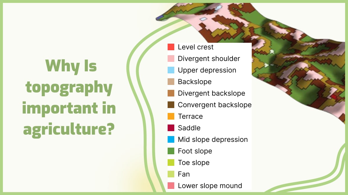
 Topography Because it impacts water runoff and its orientation affect microclimate, which in turn affects flora, it has a substantial impact on soil formation. To allow soil horizon processes to take place, the parent material must remain relatively undisturbed. Moving water across the surface removes parent material, preventing soil growth. On steeper, unvegetated slopes, water erosion is more effective. Organisms Plant and animal organisms play an essential part in the formation and composition of the soil. Organisms help decomposition, weathering, and nutrient cycling by adding organic matter. Climate has an impact on the richness and diversity of soil organisms and plant life that grow on the surface. Time Weathering mechanisms continue to work on soil parent material over time, breaking it down and decomposing it. The physical and chemical features of layers in the soil profile continue to be differentiated by horizon formation processes. As a result, older, more mature soils have a well-developed horizon sequence, but some may be weathered and leached to the point where visibly distinct layers are difficult to discern. This is a distinguishing feature of oxisols. Some geological processes prevent soil formation by constantly modifying the surface, preventing parent material from weathering for an extended length of time. For example, erosion of hillsides removes material regularly, preventing soil growth. New sediment is frequently deposited along river channels as the river rushes out onto its floodplain during floods. The process of soil formation is restarted by the constant addition of new material. During the soil growth process, climate and time interact. Warm and rainy temperatures speed up the development of soil, allowing it to reach maturity sooner. Weathering is slowed in cold climates, and soil growth takes significantly longer. 
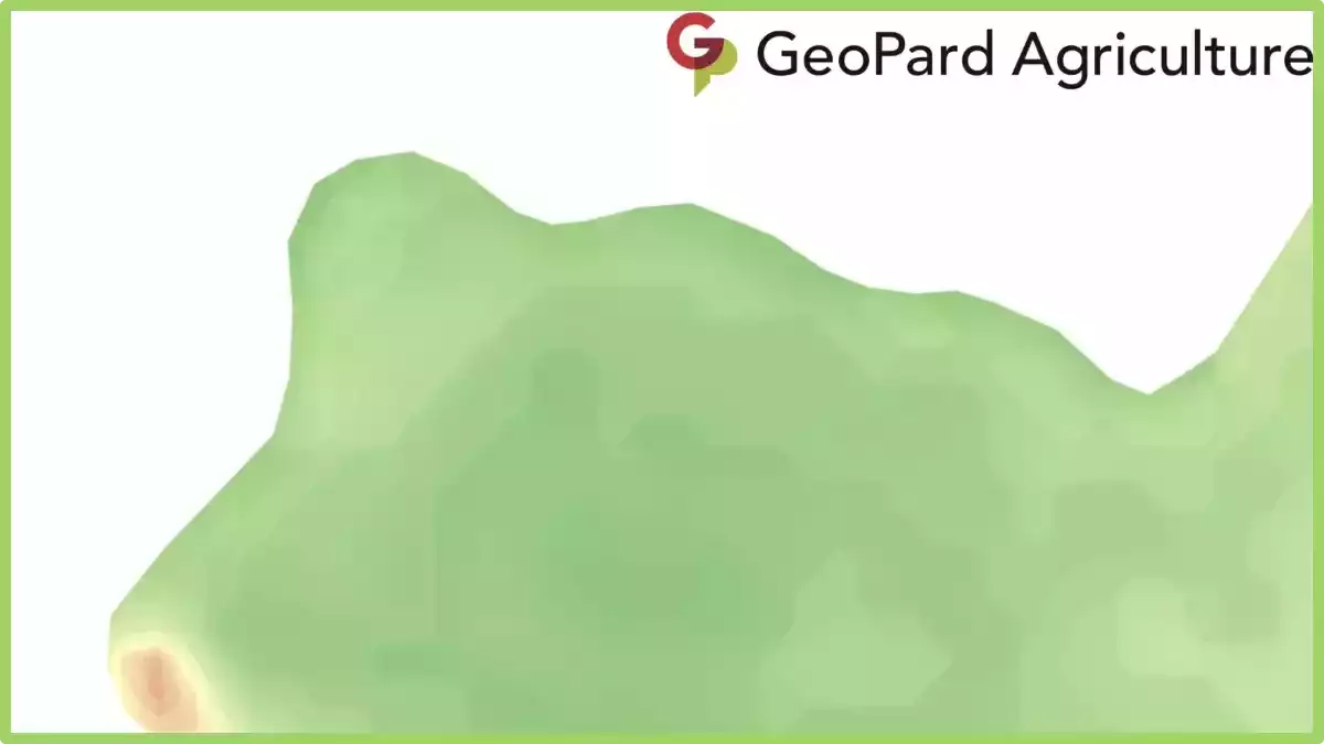
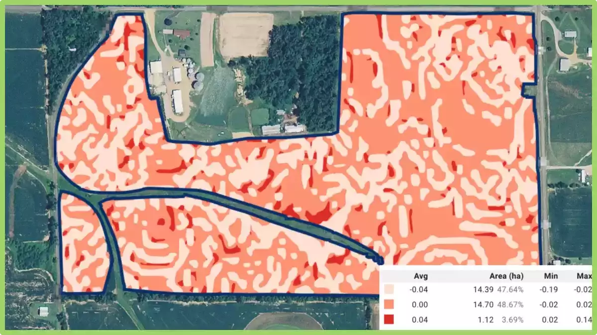
GeoPard is a new and innovative way to explore soil features and topography for better decisions and crop development. They are taking soil mapping to the next level by providing you with accurate information on soil types, soil quality, and crop suitability. GeoPard will help you make informed decisions about your farm. It’s like having your agronomist on hand. GeoPard uses advanced technology that allows you to collect data on-site which you can then use to create unique maps of your farm. These maps will show you exactly where your crops should be planted to maximize their productivity. GeoPard has all the necessary tools to create geospatial scenarios, perform spatial analyses, manage data, and visualize results. GeoPard uses different models that are based on actual field surveys, including regular elevation surfaces (with or without slope), and slope areas (with or without elevation). This technology helps farmers and agronomists to explore the soil features in a new way, create a digital terrain model (DTM) and produce maps of soil features such as rock outcrops, erosion gullies, sand dunes, canyons, slope gradients, etc.

Frequently Asked Questions


1. How does topography affect climate? How do mountain ranges take part? It has a significant influence on climate patterns. Mountains, for example, can block the passage of prevailing winds, causing the windward side to experience higher rainfall and the leeward side to be drier, creating a rain shadow effect. It also affects temperature, as higher elevations generally experience cooler temperatures due to reduced air pressure and thinner atmosphere. Moreover, it influences local air circulation and the formation of microclimates, leading to variations in temperature, humidity, and wind patterns across different slopes and valleys. 2. Which of the following crops is grown at lower elevations? Crops that are typically grown at lower elevations include those that prefer warmer climates and lower altitudes. Examples of such crops include tropical fruits like bananas, citrus fruits, and pineapples. Other crops commonly grown at lower elevations are maize (corn), soybeans, cotton, and various types of vegetables such as tomatoes and peppers. These crops thrive in regions with moderate to high temperatures and require longer growing seasons, which are often found in lower elevation areas. 3. How does altitude affect climate? Altitude has a significant impact on climate due to changes in temperature and air pressure. As altitude increases, the air becomes thinner, resulting in lower atmospheric pressure. This leads to a decrease in temperature, with temperatures dropping by about 0.6 degrees Celsius for every 100 meters increase in elevation. High-altitude areas also experience more intense solar radiation, cooler average temperatures, and greater temperature variations between day and night. Additionally, altitude influences precipitation patterns, with higher elevations often receiving more rainfall or snowfall due to orographic lifting. 4. How does topography affect soil formation? It plays a vital role in soil formation through various mechanisms. Slopes and gradients affect water drainage, leading to variations in soil moisture content. Steep slopes may experience faster erosion, leading to thinner soils, while gentle slopes allow for better soil development. Topographic features like valleys and depressions can accumulate organic matter and nutrients, contributing to soil fertility. Additionally, it influences the deposition of sediments, altering soil texture and composition. 5. How does the physical geography of a place help to shape agricultural practices? The physical geography of a place plays a critical role in shaping agricultural practices. Factors like climate, topography, soil type, and water availability directly influence the choice of crops and farming techniques. For instance, areas with fertile soil and ample rainfall are suitable for diverse crop cultivation, while arid regions may require irrigation systems or drought-tolerant crops. Understanding the physical geography helps farmers adapt their practices, select appropriate crops, manage water resources, and implement soil conservation measures for sustainable and efficient agricultural production. 6. How does topography affect economic development? It has a significant impact on economic development in various ways. It can influence the availability and accessibility of resources, such as minerals or water, which can drive economic activities like mining or hydroelectric power generation. Additionally, it can affect transportation infrastructure, with steep slopes or rugged terrain presenting challenges for road or railway construction. Coastal areas with favorable soil structure can support port facilities and maritime trade. Furthermore, topographic features like mountains or scenic landscapes can attract tourism, contributing to local economies. 7. Why is flat land good for farming? Flat land is advantageous for farming due to several reasons. Firstly, it provides ease of mechanization, allowing farmers to use machinery for various tasks such as tilling, planting, and harvesting. Flat terrain also facilitates efficient irrigation and water distribution, as water can flow evenly across the field without pooling or uneven distribution. Additionally, flat land allows for uniform sunlight exposure, promoting consistent plant growth and crop development. 8. What is a features of topography that can affect the local climate? Topographic features like elevation, slope orientation, and mountain ranges can influence the local climate. Higher elevations experience cooler temperatures, slope orientation affects sunlight exposure and temperature variations, and mountains can alter wind patterns and precipitation. 9. What do mountainous regions do to create flat land for farming? Mountainous regions create flat land for farming through various practices. One common method is terrace farming, where steps or terraces are carved into the slopes to create flat surfaces for cultivation. This helps prevent soil erosion and allows water to be evenly distributed across the fields. Additionally, mountainous regions may construct irrigation systems to divert water from higher elevations to lower areas, facilitating farming on flatter terrain. Moreover, some mountainous areas employ land reclamation techniques, such as filling in valleys or creating artificial plateaus, to create more level land for agricultural purposes. 10. Which of the following areas is most suited to farming? The suitability of an area for farming depends on several factors, including climate, soil fertility, water availability, and topography. Some types of areas that are generally well-suited for farming include:
  • Plains: Flat or gently rolling areas with fertile soil and favorable climate conditions for crop cultivation.
  • River Valleys: Areas adjacent to rivers that benefit from fertile alluvial soil and access to water for irrigation.
  • Coastal Plains: Low-lying areas along coastlines that often have fertile soil and benefit from maritime influences such as mild temperatures and moisture.
  • Deltas: Landforms formed at the mouth of rivers, providing nutrient-rich soil and ample water supply for agriculture.
  • Plateaus: Elevated flat or gently sloping areas with good soil fertility and potential for irrigation, particularly in regions with suitable rainfall.
However, it’s important to note that specific crop requirements and local climate variations can further determine the suitability of these areas for farming. 11. How big is a hectare vs acre? A hectare and an acre are both units of measurement used to quantify land area, but they differ in size. A hectare is a metric unit of measurement and is equivalent to 10,000 square meters or 2.47 acres. On the other hand, an acre is an imperial unit of measurement commonly used in the United States and is equal to approximately 4,047 square meters or 0.4047 hectares. 12. What are the five soil forming factors? The five soil forming factors are climate, organisms, parent material, topography, and time. Climate influences the weathering and decomposition processes that shape soil. Organisms, such as plants, animals, and microorganisms, contribute to the formation and transformation of soil through their activities. Parent material refers to the rock or sediment from which soil is derived. Topography influences water drainage and erosion patterns, impacting soil formation. Time is a crucial factor, as it determines the degree of soil development through gradual changes over long periods.

3D Topography maps in precision agriculture

GeoPard is making history by being the first company to automate the online creation of high-resolution 3D topography maps with their new 3D mapping tool.


In just a few seconds, users can generate maps that explain the complex variability. For example, the maps help to learn how the topography and relief data of a given area influence crop development.

3D Topography Maps in precision agriculture
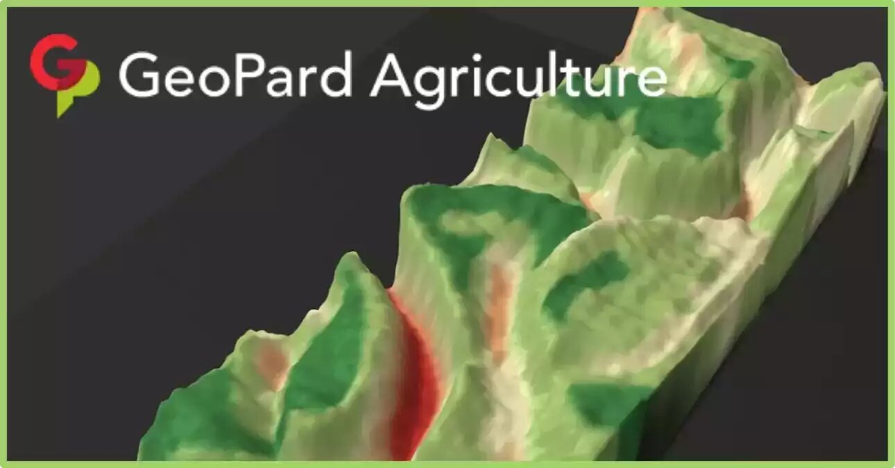
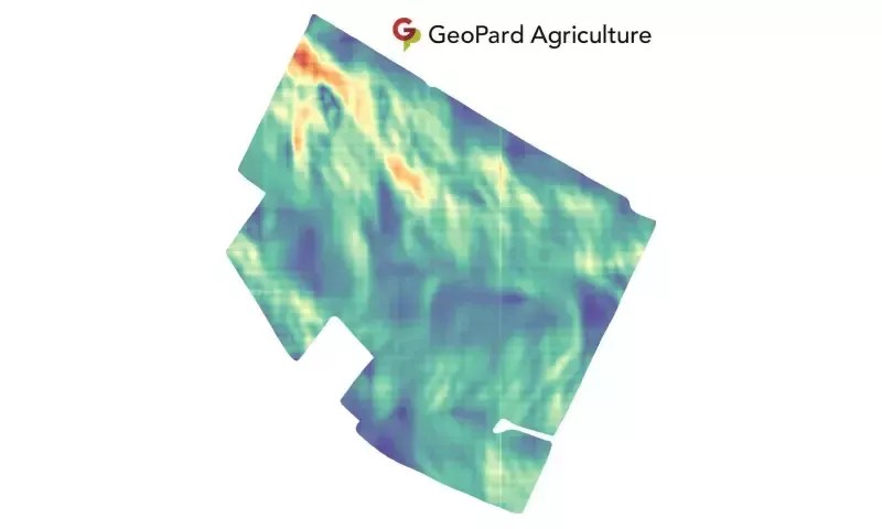
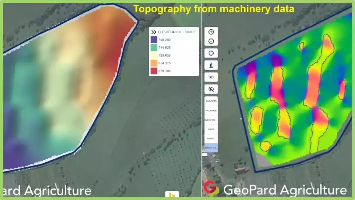
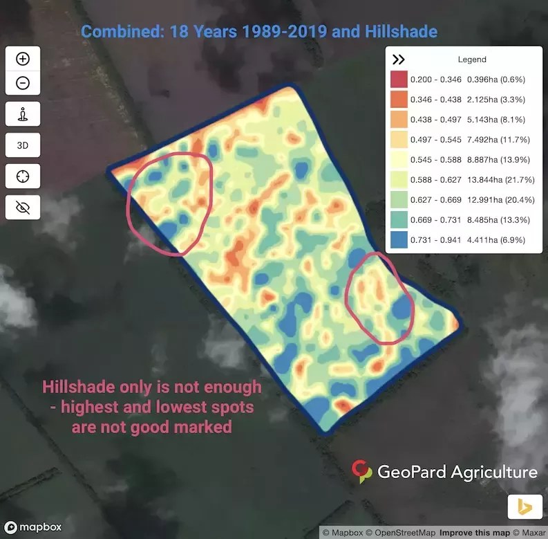
3d topography model overlaid with the Field Potential map

GeoPard is continuing its mission to make such tools more accessible for crop growers. There is no need for a powerful computer or specialized skills to start with data-driven decisions. 

What are Topography maps?

Topography maps, also known as elevation maps, are maps that depict the shape and elevation of the Earth’s surface. These maps use contour lines to show the different elevations of the land, with each line representing a constant elevation above sea level. T

he closer together the contour lines, the steeper the slope of the land, while widely spaced contour lines indicate flatter terrain.

In precision agriculture, they can be used to identify variations in slope and terrain, which can affect the distribution of water, nutrients, and other inputs across a field.

By understanding the 3d topographic maps of their fields, farmers can make informed decisions about planting, irrigation, and drainage, and can implement precision farming techniques such as variable-rate application of inputs.

They can be created using various technologies, including LiDAR (Light Detection and Ranging) and satellite imagery. These maps can be overlaid with other data, such as soil maps and yield data, to create customized prescription maps for precision agriculture applications.

Overall, they are an important tool for precision agriculture, as they provide farmers with a detailed understanding of the terrain and landscape of their fields, enabling them to optimize yields and reduce input costs.

What is 3D mapping in precision agriculture?

3D mapping in precision agriculture is a technique that uses various sensors and imaging technologies to create a detailed three-dimensional map of a farm or field.

The process typically involves the use of drones, airplanes, or ground-based vehicles equipped with sensors that capture images of the area from different angles.

These images are then processed to create a high-resolution 3D map of the field or farm that can be used to identify variations in terrain, soil types, and crop health.

This information can be used to create customized prescription maps for variable-rate application of inputs such as fertilizers, herbicides, and pesticides, and to optimize irrigation and drainage systems.

3D mapping can also be used to identify potential problem areas such as soil erosion or drainage issues, allowing farmers to take proactive measures to address them.

3D topography maps integration with GeoPard precision tool

The 3D mapping tool can be used with any GeoPard base layer in addition to LIDAR topography and its derivatives. Among the additional available layers, there are soil agrochemical properties, yield/as-applied/as-planted datasets, ground scanners data, and even vegetation indices.

Any cover map like zones from yield, historical vegetation, organic matter, electrical conductivity, or pH distribution can be utilized on top of the base layer. The 3D maps help users better understand how relief and topography influence soil properties, vegetation, and yield.

And they contribute to a better visual and analytical understanding of how to manage individual land parcels in the most efficient way. 

It is important to mention, that this Live 3d Model works directly in the browser without any 3rd party pre-installed programs or extensions. You can rotate, zoom in and zoom out, and change cover maps to understand fields better.

The latest improvement includes the capabilities to save the preferred datalayers sets for 3D maps and fastly access them later. This enables saving your current investigation state and continuing further review later.

An additional benefit here is the capability to trace changes through agricultural crop seasons within saved snapshots.

The way topography affects crop vegetation has a significant impact on crop yield (more details are in a previous blog post post here).

The marked areas represent the value of the GeoPard 3D mapping tool, which improves the understanding of the reasons for yield distribution and informs about the necessary changes in planting patterns.

Whatsmore, the 3D topographic maps model provides insight into how watersheds feed into your land and which pathways water takes.

GeoPard’s  3d topographic maps can relay essential information about surface and subsurface drainage inefficiencies, allowing irrigation and drainage systems to be reworked to optimize soil water availability for your crops.

GeoPard is aiming high with the development of new tools like this and is constantly improving and refining its own global understanding related to precision agriculture digital solution demand.

If you are interested in knowing more about how the data is collected and analyzed, feel free to check out this post to learn more!


Frequently Asked Questions


1. How to turn on topography in google earth?

To enable topography in Google Earth, follow these simple steps. First, open Google Earth on your device. Next, navigate to the “Layers” panel located on the left side of the screen.

Click on the “Primary Database” folder, and then select the checkbox next to “Terrain” or “3D Buildings” to display topographic features. You can further customize the appearance by adjusting the transparency or other settings.

With these steps, you’ll be able to view and explore the topography in Google Earth, enhancing your virtual experience of the Earth’s terrain.

2. How to make a 3d model from a topographic map?

Creating a 3D model from a topographic map involves a few steps. First, obtain a high-resolution topographic map of the desired area. Next, digitize the elevation contours from the map using specialized software or by tracing them manually.

Then, import the digitized contours into a 3D modeling software and extrude them vertically based on their elevation values. Finally, add texture and other details to the model to enhance its appearance.

With these steps, you can transform a topographic map into a 3D model, allowing for a more immersive representation of the terrain.

Use of Cropped Raster Data for Agribusiness

Cropped raster data based on field boundary sounds very simple. Some data sources are rasters with pixels and a resolution of 3m/10m/30m, others – are vectors with polygons or multipolygons.

The accurate boundary of the cropped raster data is tricky. The default output most gis and precision agriculture software have is a pixelated raster. Precise data evaluation close to the field boundary helps you better to understand, for example, canopy conditions, slope value. 

Examples of pixelated rasters:

Near-infrared pixelated raster
Elevation pixelated raster

Is it possible to improve and to make it more accurate?

Yes, GeoPard does that and even makes data available for further integration via API. Some examples:

  • Crop of raw (RedGreenBlue and NearInfrared views) satellite imagery based on field boundary:
RGB cropped raster
GeoPard Agriculture RGB cropped raster
Near-infrared cropped raster
GeoPard Agriculture Near-infrared cropped raster


  • Crop of satellite imagery with vegetation index like WDRVI based on the field boundary:


WDRVI cropped raster
GeoPard Agriculture WDRVI cropped raster


  • Crop of digital topography dataset (elevation and roughness) based on the field boundary:


Elevation cropped raster
GeoPard Agriculture Elevation cropped raster
Roughness cropped raster
GeoPard Agriculture Roughness cropped raster

How it looks in GeoPard interface and how it can be integrated in your ag tech solution:

GeoPard Agriculture NIR cropped raster
GeoPard Agriculture Relief Position
GeoPard Agriculture WDRVI

We at GeoPard understand the value of such details and are constantly working to improve the solution.

What is Raster Data?

Raster data is a type of digital image data that is represented by a grid of pixels or cells, where each cell corresponds to a specific location on the earth’s surface. Each pixel in a raster image is assigned a value that represents a particular attribute or characteristic of that location, such as elevation, temperature, or land cover.

It is commonly used in geographic information systems (GIS) and remote sensing applications to represent and analyze various types of spatial data. It can be collected from a variety of sources, including satellite and aerial imagery, digital cameras, and ground-based sensors.

It is often stored in various formats, such as GeoTIFF, JPEG, and PNG, which are designed to compress and store the data efficiently. GIS software and image processing tools can be used to manipulate and analyze data, such as by performing calculations on the pixel values or applying filters to enhance certain features.

Examples of applications include mapping land use and land cover, analyzing changes in vegetation over time, and predicting crop yields based on environmental factors.

How Raster Data Used In Precision Agriculture?

It is an essential component of precision agriculture, as it provides detailed information about crop health, soil properties, and environmental factors that can be used to make more informed decisions about crop management. Here are some examples of how raster data is used in precision agriculture:

  • Crop health analysis: Remote sensing data in the form of satellite imagery or drone imagery can be used to generate data layers that show vegetation indices such as NDVI (Normalized Difference Vegetation Index) or NDRE (Normalized Difference Red Edge). These indices help identify areas of the field with healthy vegetation, as well as areas where crops may be under stress due to disease, pests, or nutrient deficiencies.
  • Soil analysis: Soil data, such as soil moisture content or soil texture, can be collected using sensors that generate data layers. These layers can help identify areas of the field with varying soil characteristics, which can inform decisions about fertilization, irrigation, and other soil management practices.
  • Environmental analysis: Data layers that show environmental factors such as temperature, precipitation, and wind speed can be used to model crop growth and predict yield. These layers can also help identify areas of the field that are prone to erosion, flooding, or other environmental problems.
  • Variable rate application: It can be used to generate prescription maps for variable rate application of inputs such as fertilizer or pesticides. By applying inputs at varying rates according to the needs of different areas of the field, farmers can reduce waste and optimize crop growth.

Overall, raster data is a crucial tool in precision agriculture, as it provides detailed information about crop and soil conditions that can be used to make more informed decisions about crop management.

Topographic Models For Machinery and Remote Sensing

Topography often has a huge influence on nutrient distribution and yield potential. GeoPard creates topographic models from machinery, remote sensing and if available LIDAR datasets. 

Let’s dive deeper into the new topographic derivatives we just added to GeoPard.

Relief Position is defined as the difference between a central pixel and the mean of its surrounding cells. In other words, spots with negative values mean field lowland, spots with positive values – field highland.

You can have a hilltop in a “low” elevation that has very different soil properties than a mid slope or depression. Elevation, slope and aspect cannot show this. Relief position is calculated in meters.

Relief Position

Slope is the angle of inclination to the horizontal. Usually, it is calculated in degrees or percent slope. GeoPard does that in degrees.

Terrain slope

Ruggedness is defined as the mean difference between a central pixel and its surrounding cells. In other words, ruggedness describes the slope in absolute numbers (in meters) for every particular location (pixel).

ruggedness describes the slope in absolute numbers

Roughness is the degree of irregularity of the surface. It’s calculated by the largest inter-cell difference of a central pixel and its surrounding cell. In other words, it measures the maximum absolute value of the slope in meters for every location (pixel).

Roughness is the degree of irregularity of the surface.

These four topographic derivatives reflect the slope details but in a bit different flavour.

our topographic derivatives reflect the slope details

What is Topographic Modeling?

Topographic modeling is the process of creating a three-dimensional representation of the Earth’s surface. This is done by collecting data on the elevation of the land, such as through surveying or satellite imagery, and then using this data to create a digital elevation model (DEM).

The DEM can then be used to create a variety of outputs, such as topographic maps, 3D models, and even virtual reality experiences.

It has a wide range of applications, including:

  • Planning and development: Topographic models can be used to plan and develop infrastructure, such as roads, railways, and pipelines. They can also be used to assess the impact of development on the environment.
  • Environmental management: Topographic models can be used to monitor and manage natural resources, such as water, forests, and wildlife. They can also be used to assess the impact of climate change on the environment.
  • Education and research: Topographic models can be used to educate the public about the Earth’s surface and its features. They can also be used by researchers to study the Earth’s surface and its processes.

How is Topographic Modeling Done?

It can be done in a variety of ways, but the most common method is to use a DEM.

A DEM is a gridded representation of the Earth’s surface, with each cell in the grid representing a point with a known elevation. DEMs can be created from a variety of sources, including:

  • Surveying: Surveyors use a variety of tools to measure the elevation of the land, such as levels, theodolites, and GPS receivers.
  • Satellite imagery: Satellites can be used to create DEMs by measuring the distance between the satellite and the Earth’s surface.
  • Aerial photography: Aerial photographs can be used to create DEMs by measuring the distance between the camera and the Earth’s surface.

Once a DEM has been created, it can be used to create a variety of outputs, such as topographic maps, 3D models, and even virtual reality experiences.

Benefits of Topographic Modeling

Further, it offers a number of benefits, including:

  • Accuracy: DEMs are highly accurate representations of the Earth’s surface. This is important for applications such as planning and development, where accuracy is essential.
  • Visualization: Topographic models provide a clear and concise visualization of the Earth’s surface. This can be helpful for understanding the relationship between different features, such as mountains, valleys, and rivers.
  • Analysis: Topographic models can be used to analyze the Earth’s surface. This can be used to identify areas that are at risk of flooding, landslides, or other natural disasters.
  • Communication: Topographic models can be used to communicate information about the Earth’s surface to a wide range of audiences. This can be helpful for educating the public about the Earth’s surface and its features.

What is Topography Lidar?

Lidar (Light Detection and Ranging) is a remote sensing technology that uses light to measure distance to the Earth’s surface. It works by sending out a laser pulse and measuring the time it takes for the pulse to return. This information can be used to create three-dimensional (3D) models of the Earth’s surface.

Topographic lidar is a type of lidar that is specifically used to create 3D models of the Earth’s topography.

How Topography Lidar Works

These systems typically consist of a laser, a scanner, and a GPS receiver. The laser is used to emit pulses of light, the scanner is used to measure the direction of the pulses, and the GPS receiver is used to track the location of the system.

The laser pulses are emitted in a series of lines, and the scanner measures the intensity of the pulses as they return. This information is used to create a 3D model of the Earth’s surface.

Its data accuracy depends on a number of factors, including the power of the laser, the sensitivity of the scanner, and the speed of the GPS receiver.

Applications of Topography Lidar

It data can be used for a variety of applications, including:

  • Mapping the Earth’s surface
  • Monitoring changes in the Earth’s surface
  • Assessing natural hazards
  • Planning infrastructure projects
  • Conducting scientific research

Mapping the Earth’s surface

It can be used to create detailed maps of the Earth’s surface. These maps can be used for a variety of purposes, such as planning infrastructure projects, assessing natural hazards, and conducting scientific research.

Monitoring changes in the Earth’s surface

It can be used to monitor changes in the Earth’s surface over time. This information can be used to track the effects of natural processes, such as erosion and sedimentation, and human activities, such as deforestation and construction.

Assessing natural hazards

It is used to assess natural hazards, such as landslides, floods, and earthquakes. This information can be used to identify areas that are at risk and to develop mitigation strategies.

Planning infrastructure projects

It is used to plan infrastructure projects, such as roads, bridges, and pipelines. This information can be used to identify the best routes for projects and to minimize the impact on the environment.

Conducting scientific research

It can be used to conduct scientific research on a variety of topics, such as geology, hydrology, and ecology. This information can be used to better understand the Earth’s systems and to develop new technologies.

Benefits of Topography Lidar

It has a number of benefits over other methods of mapping the Earth’s surface, including:

  • Accuracy: It is very accurate, making it ideal for applications where precision is important.
  • Speed: It can be collected quickly, making it a cost-effective option for large-scale mapping projects.
  • Flexibility: It can be used to map a variety of features, including both natural and man-made objects.
  • 3D data: It is 3D, which allows for more accurate and detailed representations of the Earth’s surface.

Topographic modeling is a powerful tool that can be used to create a variety of outputs, including topographic maps, 3D models, and even virtual reality experiences. It offers a number of benefits, including accuracy, visualization, analysis, and communication. 

Topography based on machinery data

A lot of data collected from the fields is not used by farmers and agronomists. As an example, almost any modern machinery has a GPS receiver which is capable of gathering elevation data, quite often accuracy is improved with Real-time kinematic (RTK). 

Most of this data is not actively used, because it is quite a time consuming to extract, clean, and process this information to acquire real value out of it. One of the GeoPard main idea is to decrease the complexity of data usage in Precision Agriculture. 

GeoPard is capable of automatically extracting high-accuracy elevation data from:

  • Yield datasets
  • EC/other sensors datasets

GeoPard utilized the best available topography dataset for every field, but, unfortunately, high-accuracy lidar data is not available for every location in the world. Therefore, a machinery data-based digital elevation model will be a perfect option and significantly improves knowledge about the field. 

Henceforth, as any data layer in GeoPard, you can create zones out of machinery elevation data with Zones Creator, use this data in the Zones Ops module (finding of overlappings among different datasets) and use it in multi-layer analytics.

Note that it is also possible to compare remote sensing based VS machinery/RTK based topography models.

What are topographic equipment?

Topographic equipment refers to the specialized tools and instruments used in the field of topography, which is the study and mapping of the surface features of the Earth.

What are topographic equipment

These tools are designed to measure and record various aspects of the land’s topography, including elevation, slope, and contours. Here are some commonly used topographic equipment:

  • Total Station: A total station is an electronic surveying instrument that combines the functions of a theodolite (used for measuring horizontal and vertical angles) and an electronic distance meter (EDM) to measure distances. It is used for precise positioning and measuring angles and distances in topographic surveys.
  • GPS (Global Positioning System) Receiver: GPS receivers use signals from satellites to determine accurate positions on Earth’s surface. In topography, GPS receivers are used to establish control points and measure coordinates, which are crucial for creating accurate topographic maps.
  • Leveling Instrument: Leveling instruments, such as a dumpy level or digital level, are used to measure height differences or elevations between different points on the ground. They help in determining contours and slopes of the land.
  • LiDAR (Light Detection and Ranging): LiDAR is a remote sensing technology that uses laser light to measure distances and create detailed three-dimensional maps. It is commonly used in aerial or ground-based surveys to capture high-resolution elevation data.
  • Photogrammetric Equipment: Photogrammetry involves obtaining measurements from photographs. Specialized cameras, topographer machine, drones, or unmanned aerial vehicles (UAVs) equipped with high-resolution cameras are used to capture aerial images. Photogrammetric software is then used to process these images and extract topographic information.
  • Handheld GPS Devices: Handheld GPS devices provide accurate position data in real-time. They are portable and used for navigation, mapping, and data collection in the field.
  • Field Books and Measuring Tools: Field books are used by surveyors to record measurements, sketches, and notes during topographic surveys. Measuring tools like measuring tapes, ranging poles, and flagging tape are used for measuring distances and marking points of interest.

These are some of the essential topographic equipment used in the field. It’s important to note that technological advancements may introduce new tools or variations of existing equipment, so staying updated with the latest developments is recommended.

What is topographer machine?

A topographer machine, also known as a topographic surveying machine or a topographic mapping system, is a specialized tool used in agriculture for the precise measurement and mapping of the physical features of a field or agricultural land.

What is topographer machine in agriculture

It is designed to capture accurate elevation data and create detailed topographic maps that represent the terrain’s contours, slopes, and other essential characteristics.

The topographer machine typically consists of advanced surveying equipment, including Global Positioning System (GPS) receivers, laser scanners, LiDAR (Light Detection and Ranging) sensors, and onboard computers.

These components work together to collect precise location data and measure the elevation of various points across the agricultural land.

The machine is operated by agricultural professionals or trained technicians who deploy it in the field. As the topographer machine moves through the area, it uses GPS signals to determine its position and laser or LiDAR technology to measure the height of the terrain. The collected data is then processed and analyzed to create accurate topographic maps.

The generated topographic maps provide valuable information to farmers and land managers. They allow for better planning and management of agricultural activities, such as irrigation, drainage, and land leveling.

By understanding the topography of the land, farmers can optimize their farming practices, minimize soil erosion, and enhance overall crop productivity.

In conclusion, topographic equipment plays a vital role in accurately measuring and mapping the surface features of the Earth in the field of topography. The information gathered using these tools is crucial for creating detailed topographic maps, which in turn aid in effective land management, planning agricultural activities, and optimizing farming practices. 

Multi layer (integrated) data analysis in precision agriculture

Precision agriculture is capable of generating vast amounts of data in the form of yield data, satellite imagery, and soil fertility, among others.

The lack of easy-to-use cloud precision software toolkits that assist crop producers in converting field data layers into useful knowledge and actionable recommendations limits the application of precision agricultural technologies.

In precision agriculture, management zones are areas within a field that have similar yield potential based on soil type, slope position, soil chemistry, microclimate, and/or other factors that influence crop production.

The producer’s knowledge of a field is a very important piece of the process. Management zones are thought of as a mechanism to optimize crop inputs and yield potential.

Maps generated with a single data layer and several data layers.

The big challenge is to build management zones that perfectly reflect field variability. A combination of different layers like satellite imagery, soil fertility, topography derivatives, and yield monitor data is the next logical step to generating more responsive management zones.

Multi layer analytics (also known as integrated analysis) is becoming a part of the GeoPard geospatial analytics engine.

Classic combinations of integrated analysis parameters include one or more yield data, NDVI map, elevation, and soil sensor physicochemical characteristics. 

GeoPard supports these parameters and in addition, allows the inclusion of other field data layers either already available in the system or uploaded directly by the user (soil sampling, yield datasets, etc.).

As a result, you are free to operate with the complete set of parameters doing integrated analytics:

Multi layer yield data analytics

Remote sensing data:

  • Potential productivity map (single-year and multi-year)
  • Stability/variation map
  • Vegetation indices NDVI, EVI2, WDRVI, LAI, SAVI, OSAVI, GCI, GNDVI

Topography:

  • Digital elevation
  • Slope
  • Curvature
  • Wetness index
  • Hillshades

Soil data:

  • pH
  • CEC (cation exchange capacity)
  • SOM (soil organic matter)
  • K (potassium)
  • Thin topsoil depth, lower available water holding capacity (drought-prone soil)
  • EC (electrical conductivity)
  • and other chemical attributes available in the uploaded dataset

It’s important to emphasize that custom factors are configured on top of every data layer to assign the desired layer weight. You are very welcome to share your integrated analytics use cases, and build management zone maps based on your knowledge of the field while selecting data sources and their weights in GeoPard.

Pictures in this blog contain a sample field with data layers (like a productivity map covering 18 years, digital elevation model, slope, hillshade, 2019 yield data) and various combinations of integration analytics maps. 

You can follow the steps of the evolution of management zones while extending integration analytics with an additional data layer.


Frequently Asked Questions


1. What is data layers?

Data layers refer to the individual components or elements of data that are organized and stacked together to create a comprehensive representation of a specific area or subject.

Each layer represents a specific aspect of the data, such as geographical features, land use, population density, or environmental factors. These layers can be combined and analyzed collectively to gain insights, visualize patterns, and make informed decisions.

Data layers are commonly used in geographic information systems (GIS) and spatial analysis to better understand and represent complex data in a visual and interpretable manner.

2. What is integrated analysis?

Integrated analysis refers to the process of combining and analyzing data from multiple sources or disciplines to gain a more comprehensive and holistic understanding of a particular problem or phenomenon.

It involves merging data sets, applying statistical techniques, and exploring relationships across different variables or domains.

Integrated analysis allows for a more nuanced and interconnected view of complex systems, facilitating the identification of patterns, trends, and causal relationships that may not be evident when analyzing data in isolation.

This approach enables researchers and decision-makers to make more informed and effective decisions based on a broader range of information.

wpChatIcon
wpChatIcon

    Request Free GeoPard Demo / Consultation


    By clicking the button you agree our Privacy Policy. We need it to reply to your request.

      Subscribe


      By clicking the button you agree our Privacy Policy

        Send us information


        By clicking the button you agree our Privacy Policy