GeoPard Integration with the John Deere Operations Center

Connect your John Deere & GeoPard workflows

GeoPard seamlessly integrates with the John Deere Operations Center, bringing advanced analytics to the forefront of precision farming.

Our platform enhances the capabilities of John Deere tech, providing dealers and farmers with actionable insights for optimal agricultural outcomes.

John Deere Operations Center precision agricultured data analytics with GeoPard software

Create John Deere WorkPlans

API integration allows us create workplans in seconds, directly sent to the JohnDeere

GeoPard JohnDeere Ops Center Data flows

Automated bi-directional data sync with the Ops center

Send any analytics layer to the Ops Center

NUE, Profit maps, Topography, Soil, Calibrated Yield – all are sent to the Ops Center in an automated manner

JohnDeere Ops Center data sync page in GeoPard

Flexible options allow to sync boundaries, agronomic data, automatically send analytics layers & VRA Rx to the Ops center

GrainSensing HarvestLab data analysis

Use-case LVA, John Deere dealer helps farmers to calculate Fertilizer use efficiency by analyzing Protein, Harvesting, As-Applied data in GeoPard.

Send Soil data to the Ops Center

Send Soil Sampling or Soil Scanning results to the Ops Center

See any soil attribute in the Ops Center

GeoPard sends the soil data in the right format to the Ops center. Compare it to seeding, harvesting data or plan soil sampling

Profit Maps calculations

Profit Maps Equations allows you to calculate sub-field cross-margin maps. It takes into account as-applied, as-planted, harvesting data. You just need to set price per product, GeoPard does the rest

Manage & Analyze all precisionAg data in one place

No need to have several apps to visualize and analyze your farm data

Cleaning and Calibrating data from multiple harvesters

Accurate Harvesting data is essential to understand your fields productivity and profitability. GeoPard helps you to get accurate Yield maps with A.I. cleaning and calibration models

GeoPard enables quick creating of the John Deere WorkPlans

Available for Seeding and Application operations

Slope calculated from RTK Yield data, available in the Ops Center

Topography calculated from RTK Yield data, send to Ops center

Send Topography, Soil or Analytics layers into John Deere Ops Center in one click

John Deere Operations Center Connected Analytics Software. Enrich Operations Center with GeoPard Analytics

Key Features

Bi-directional Automated Data & Analytics Exchange

1. Import from John Deere Operations Center to GeoPard

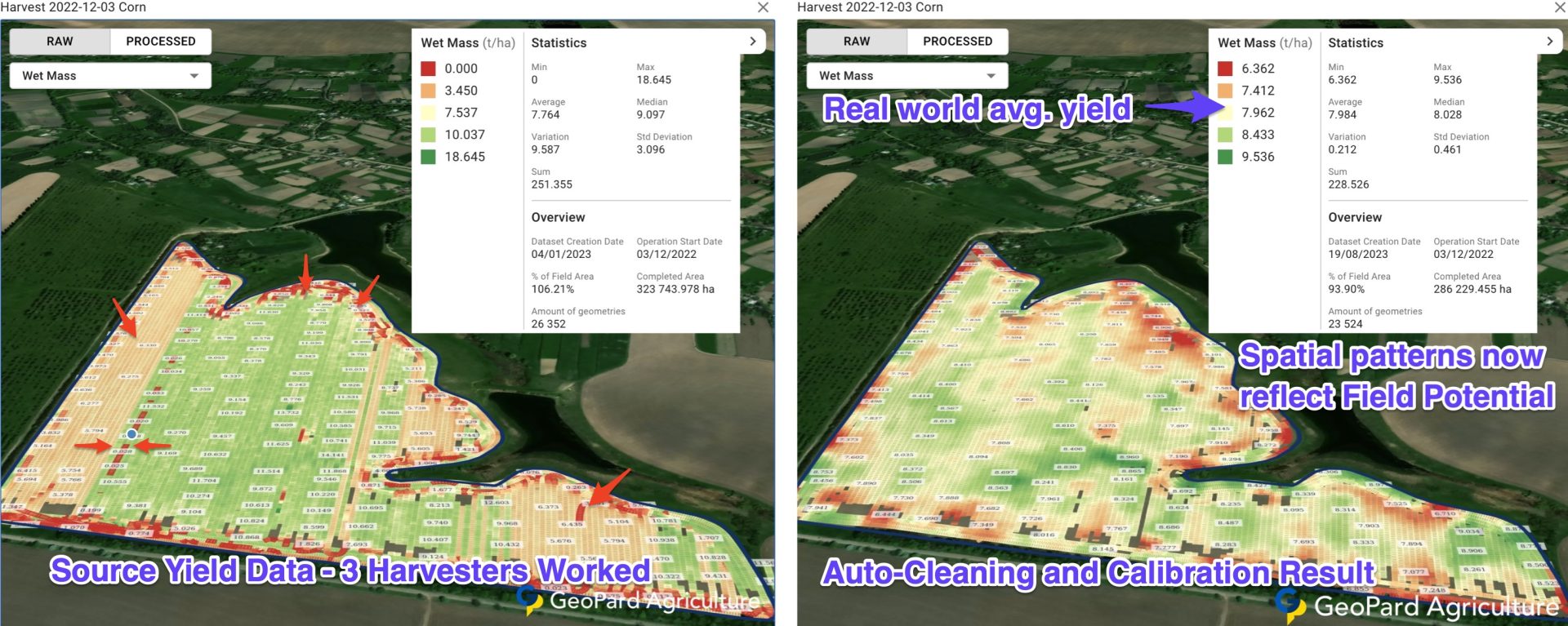
Field Boundaries, Operation Maps, Seeding Data, Application Data, Harvesting Data, Tillage Data, and more. Automatically import & Export JohnDeere data.

2. Run advanced Data analytics

3. Export from GeoPard to John Deere Operations Center

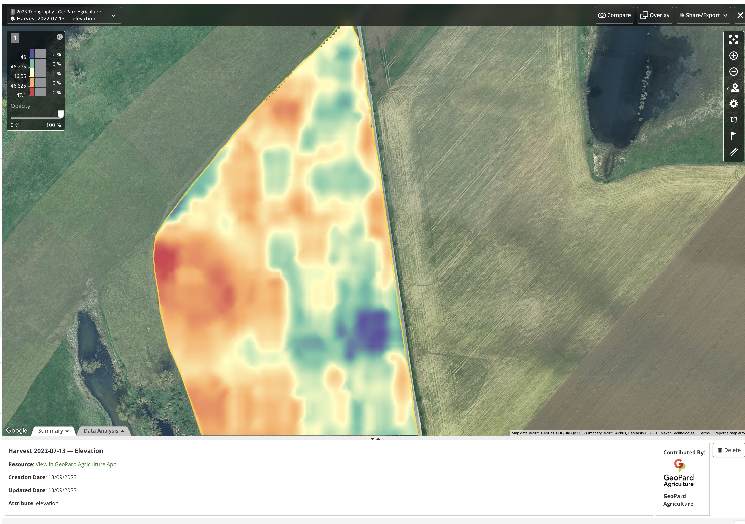
Field Boundaries, VRA maps, Management Zones, Topography maps, Soil Maps, Satellite images, Cleaned Yield data, Profit Maps, NUE maps and Rx vs As-applied analytics.

4. Collaborate with your agronomy service providers and clients

As a Dealer, you can offer your clients (farmers) analytics, prescription maps, and insights.

As a Farmer, share your farm data with a trusted advisor on GeoPard for data-driven insights.

wpChatIcon
wpChatIcon

    Request Free GeoPard Demo / Consultation


    By clicking the button you agree our Privacy Policy. We need it to reply to your request.

      Subscribe


      By clicking the button you agree our Privacy Policy

        Send us information


        By clicking the button you agree our Privacy Policy