Topography and nutrition content in soil and yield

The topography of the land, climate, and soil type can have a significant effect on the nutrient content of crops. It has been demonstrated that soil topography has a substantial effect on its fertility. The steepness of the slope and its inclination concerning the sun have a marked influence on the amount of radiant heat received by any given area, and the greater this is, the more rapidly plants will grow. The fertility of soils depends largely upon their composition, structure, and texture. Soils with a high proportion of sand in their composition are generally more fertile than those containing large amounts of clay; soils that are loose in texture are easier to cultivate than those which are compact; sandy loams are most suitable for growing cereals as they contain good quantities of humus. The chemical composition of soil depends largely upon what type of rock material it was derived from. Sandstones and shales usually form poor soils, while limestones give rise to rich loams which are well suited for arable farming. As an example, consider the following: The larger amounts of rainfall in wet regions allow greater biological activity in the soil. This biological activity leads to a more rapid breakdown of organic matter into soil nutrients. The higher temperatures also hasten decomposition. As a result, crops grown in wet regions tend to have higher concentrations of nitrogen and other plant nutrients than those grown in dry regions. Crops are grown at high altitudes generally have lower nitrogen concentrations because there is less biological activity at high altitudes and because air temperatures are cooler than those at lower altitudes.

What is topography?

Definition: Topography refers to the study and description of the physical features and characteristics of the Earth’s surface, including its landforms, such as mountains, hills, valleys, plains, plateaus, and bodies of water like rivers, lakes, and oceans. It examines the arrangement, elevation, and distribution of these features on the Earth’s surface. What is topography? It involves measuring and mapping the natural and artificial features of a specific area or region. It provides detailed information about the shape, relief, and slope of the land, as well as the location and extent of natural and man-made features. Topographic maps are created using a combination of ground surveys, aerial photography, and satellite imagery to accurately represent the three-dimensional characteristics of the Earth’s surface on a two-dimensional map. Its primary purpose is to understand and analyze the physical properties of the Earth’s surface, which can be essential for various applications. For example, it plays a crucial role in land development and urban planning, as it helps identify suitable locations for construction, assesses the feasibility of infrastructure projects, and determines potential flood zones. It is also vital in natural resource management, environmental studies, and geological research, as it provides valuable information about soil types, water drainage patterns, vegetation distribution, and geological formations. It is commonly used in disciplines such as geography, geology, civil engineering, environmental science, and urban planning. It allows scientists, engineers, and planners to comprehend the terrain, evaluate its impact on human activities, and make informed decisions regarding land use, resource management, and infrastructure development.

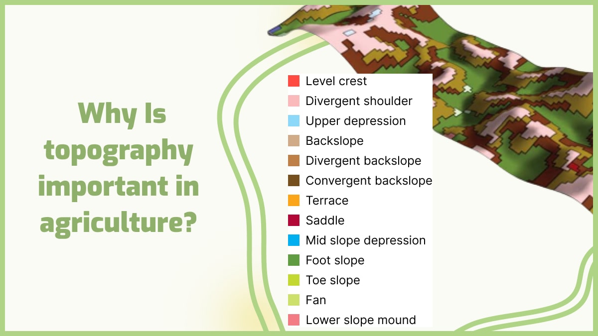
Why is topography so important in agriculture?

It affect the climate in that it influences wind patterns and weather patterns. For example, mountains block cold air from flowing over the warm ground below them, which results in warmer temperatures on one side of the mountain range than on the other side. It affects agricultural production because it affect how water flows through an area. For example, if water flows downhill quickly, it can carry away soil nutrients or leave crops too dry for optimal growth (depending on what type of crops are grown). If water flows slowly through an area, then it can provide moisture to plants over a longer period but also increase erosion by carrying away soil particles with it. Also, it affect agricultural productivity by determining how much sunlight reaches plants at different points within an area. In general, flat areas receive more sunlight than hilly areas because there are fewer obstructions between plants and the sun’s rays that could block them from reaching their leaves. The topography of a region has a significant impact on the agricultural activities that can be carried out there. In particular, it determines how much water is available to irrigate crops and how much rainfall will be received by different parts of a country. It affect agriculture because it determines if an area will be wetter or drier than another area and if a farmer wants to grow certain crops. It also affect how easily you can move around, which can have an impact on the types of crops that are grown locally. For example, if there are mountains or hills in your area, they may make it difficult for farmers to get their products to market because they would have to take a long time going up and down the hillsides with their produce. Such terrain would make it difficult for them to transport their produce quickly enough for it to reach consumers in time before it spoils. Importance of topography in agriculture It can also affect what type of equipment and machinery will work best on a farm. For example, hillsides are often too steep for tractors so farmers must rely on their muscle power to get things done. Further, it affect how much labor it takes to run the farm. If the land is flat and smooth then it won’t take much effort for workers to move around during the planting or harvesting season but if it’s hilly or uneven then they’ll have to use more energy just to get around. Another reason that it is important in agriculture is that it affect how much rain each area gets each year. If an area has a lot of mountains around it, then it will receive more rain than an area with flat land because more clouds are forming over those mountains and releasing their water into those areas which makes them wetter than other places around them. Plant biologists use it as one factor in determining where plants are native to, or where they may be able to thrive and survive if planted in another location. This includes crops like wheat and corn that are grown widely around the world.

How does it affect the soil?

Soil profiles are controlled by five distinct, although interconnected, factors: parent material, climate, organisms, and time, according to soil study. These are referred to as soil formation factors by soil scientists. Soil profiles have different characteristics. Parent Material The substance from which soil originates is known as soil parent material, and it can be a rock that has disintegrated in place or material deposited by wind, water, or ice. The parent material’s character and chemical composition are essential factors in defining soil qualities, especially during the early phases of formation. Soils produced on coarse-grained parent material that is composed of weather-resistant minerals are likely to have coarse grain texture. When the parent material is made up of unstable minerals that weather quickly, fine-grained soil forms. Soil chemistry and fertility are directly influenced by parent material composition. Calcium, magnesium, potassium, and sodium-rich parent materials are easily dissolved in water and made available to plants. In humid areas, limestone and basaltic lava both contain a high amount of soluble bases and form productive soil. Water moving through the soil removes the bases and replaces them with hydrogen ions if the parent materials are low in soluble ions, rendering the soil acidic and unsuitable for agriculture. Soils formed on sandstone have low soluble bases and a coarse structure, making leaching easier. As parent material is transformed and the climate becomes more important, its influence on soil qualities tends to diminish over time. Climate Soils, especially on the global scale, have a high geographical link with climate. Physical and chemical reactions on parent material are highly influenced by energy and precipitation. Climate influences vegetation cover, which affects soil development. How does topography affect the soil? Precipitation has an impact on horizon formation elements such as dissolved ion translocation via the soil. Climate has become a more important influence on soil qualities over time, while parent material has become less important. Topography Because it impacts water runoff and its orientation affect microclimate, which in turn affects flora, it has a substantial impact on soil formation. To allow soil horizon processes to take place, the parent material must remain relatively undisturbed. Moving water across the surface removes parent material, preventing soil growth. On steeper, unvegetated slopes, water erosion is more effective. Organisms Plant and animal organisms play an essential part in the formation and composition of the soil. Organisms help decomposition, weathering, and nutrient cycling by adding organic matter. Climate has an impact on the richness and diversity of soil organisms and plant life that grow on the surface. Time Weathering mechanisms continue to work on soil parent material over time, breaking it down and decomposing it. The physical and chemical features of layers in the soil profile continue to be differentiated by horizon formation processes. As a result, older, more mature soils have a well-developed horizon sequence, but some may be weathered and leached to the point where visibly distinct layers are difficult to discern. This is a distinguishing feature of oxisols. Some geological processes prevent soil formation by constantly modifying the surface, preventing parent material from weathering for an extended length of time. For example, erosion of hillsides removes material regularly, preventing soil growth. New sediment is frequently deposited along river channels as the river rushes out onto its floodplain during floods. The process of soil formation is restarted by the constant addition of new material. During the soil growth process, climate and time interact. Warm and rainy temperatures speed up the development of soil, allowing it to reach maturity sooner. Weathering is slowed in cold climates, and soil growth takes significantly longer. 
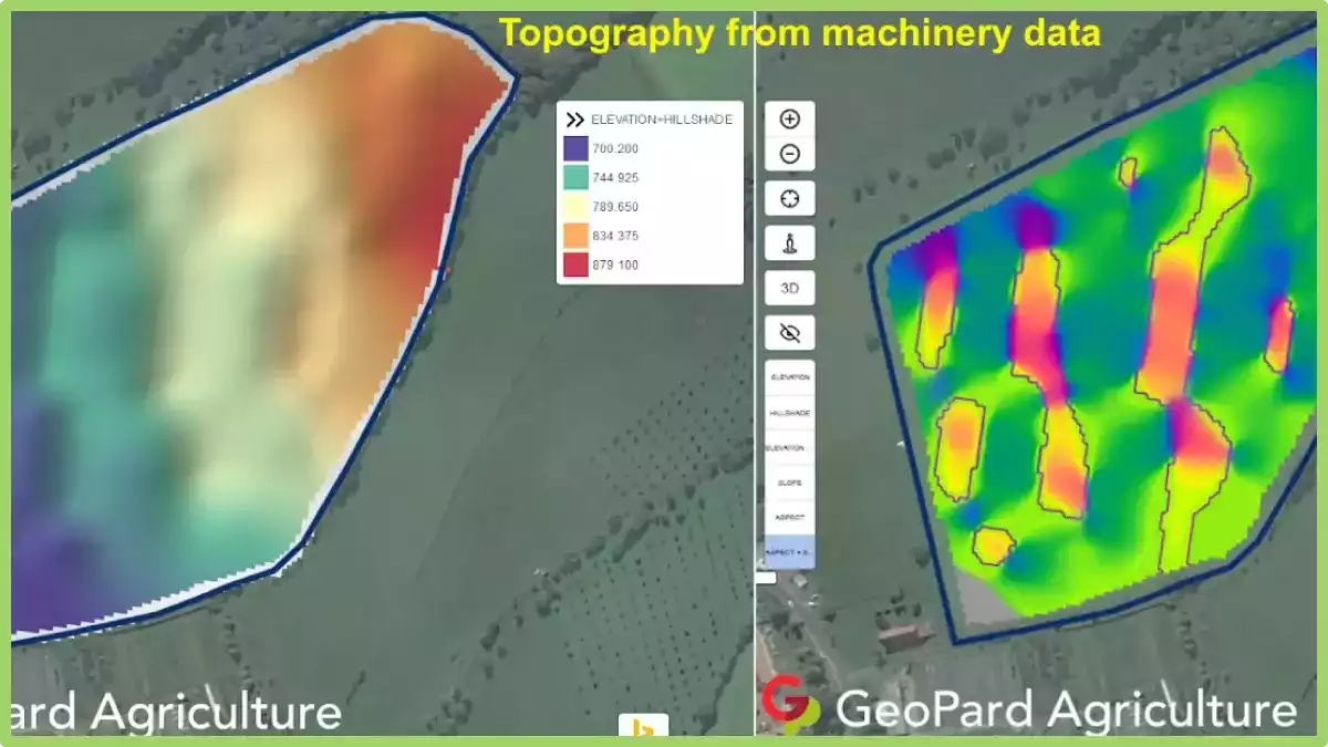
GeoPard is a new and innovative way to explore soil features and topography for better decisions and crop development. They are taking soil mapping to the next level by providing you with accurate information on soil types, soil quality, and crop suitability. GeoPard will help you make informed decisions about your farm. It’s like having your agronomist on hand. GeoPard uses advanced technology that allows you to collect data on-site which you can then use to create unique maps of your farm. These maps will show you exactly where your crops should be planted to maximize their productivity. GeoPard has all the necessary tools to create geospatial scenarios, perform spatial analyses, manage data, and visualize results. GeoPard uses different models that are based on actual field surveys, including regular elevation surfaces (with or without slope), and slope areas (with or without elevation). This technology helps farmers and agronomists to explore the soil features in a new way, create a digital terrain model (DTM) and produce maps of soil features such as rock outcrops, erosion gullies, sand dunes, canyons, slope gradients, etc.

Frequently Asked Questions


1. How does topography affect climate? How do mountain ranges take part? It has a significant influence on climate patterns. Mountains, for example, can block the passage of prevailing winds, causing the windward side to experience higher rainfall and the leeward side to be drier, creating a rain shadow effect. It also affects temperature, as higher elevations generally experience cooler temperatures due to reduced air pressure and thinner atmosphere. Moreover, it influences local air circulation and the formation of microclimates, leading to variations in temperature, humidity, and wind patterns across different slopes and valleys. 2. Which of the following crops is grown at lower elevations? Crops that are typically grown at lower elevations include those that prefer warmer climates and lower altitudes. Examples of such crops include tropical fruits like bananas, citrus fruits, and pineapples. Other crops commonly grown at lower elevations are maize (corn), soybeans, cotton, and various types of vegetables such as tomatoes and peppers. These crops thrive in regions with moderate to high temperatures and require longer growing seasons, which are often found in lower elevation areas. 3. How does altitude affect climate? Altitude has a significant impact on climate due to changes in temperature and air pressure. As altitude increases, the air becomes thinner, resulting in lower atmospheric pressure. This leads to a decrease in temperature, with temperatures dropping by about 0.6 degrees Celsius for every 100 meters increase in elevation. High-altitude areas also experience more intense solar radiation, cooler average temperatures, and greater temperature variations between day and night. Additionally, altitude influences precipitation patterns, with higher elevations often receiving more rainfall or snowfall due to orographic lifting. 4. How does topography affect soil formation? It plays a vital role in soil formation through various mechanisms. Slopes and gradients affect water drainage, leading to variations in soil moisture content. Steep slopes may experience faster erosion, leading to thinner soils, while gentle slopes allow for better soil development. Topographic features like valleys and depressions can accumulate organic matter and nutrients, contributing to soil fertility. Additionally, it influences the deposition of sediments, altering soil texture and composition. 5. How does the physical geography of a place help to shape agricultural practices? The physical geography of a place plays a critical role in shaping agricultural practices. Factors like climate, topography, soil type, and water availability directly influence the choice of crops and farming techniques. For instance, areas with fertile soil and ample rainfall are suitable for diverse crop cultivation, while arid regions may require irrigation systems or drought-tolerant crops. Understanding the physical geography helps farmers adapt their practices, select appropriate crops, manage water resources, and implement soil conservation measures for sustainable and efficient agricultural production. 6. How does topography affect economic development? It has a significant impact on economic development in various ways. It can influence the availability and accessibility of resources, such as minerals or water, which can drive economic activities like mining or hydroelectric power generation. Additionally, it can affect transportation infrastructure, with steep slopes or rugged terrain presenting challenges for road or railway construction. Coastal areas with favorable soil structure can support port facilities and maritime trade. Furthermore, topographic features like mountains or scenic landscapes can attract tourism, contributing to local economies. 7. Why is flat land good for farming? Flat land is advantageous for farming due to several reasons. Firstly, it provides ease of mechanization, allowing farmers to use machinery for various tasks such as tilling, planting, and harvesting. Flat terrain also facilitates efficient irrigation and water distribution, as water can flow evenly across the field without pooling or uneven distribution. Additionally, flat land allows for uniform sunlight exposure, promoting consistent plant growth and crop development. 8. What is a features of topography that can affect the local climate? Topographic features like elevation, slope orientation, and mountain ranges can influence the local climate. Higher elevations experience cooler temperatures, slope orientation affects sunlight exposure and temperature variations, and mountains can alter wind patterns and precipitation. 9. What do mountainous regions do to create flat land for farming? Mountainous regions create flat land for farming through various practices. One common method is terrace farming, where steps or terraces are carved into the slopes to create flat surfaces for cultivation. This helps prevent soil erosion and allows water to be evenly distributed across the fields. Additionally, mountainous regions may construct irrigation systems to divert water from higher elevations to lower areas, facilitating farming on flatter terrain. Moreover, some mountainous areas employ land reclamation techniques, such as filling in valleys or creating artificial plateaus, to create more level land for agricultural purposes. 10. Which of the following areas is most suited to farming? The suitability of an area for farming depends on several factors, including climate, soil fertility, water availability, and topography. Some types of areas that are generally well-suited for farming include:
  • Plains: Flat or gently rolling areas with fertile soil and favorable climate conditions for crop cultivation.
  • River Valleys: Areas adjacent to rivers that benefit from fertile alluvial soil and access to water for irrigation.
  • Coastal Plains: Low-lying areas along coastlines that often have fertile soil and benefit from maritime influences such as mild temperatures and moisture.
  • Deltas: Landforms formed at the mouth of rivers, providing nutrient-rich soil and ample water supply for agriculture.
  • Plateaus: Elevated flat or gently sloping areas with good soil fertility and potential for irrigation, particularly in regions with suitable rainfall.
However, it’s important to note that specific crop requirements and local climate variations can further determine the suitability of these areas for farming. 11. How big is a hectare vs acre? A hectare and an acre are both units of measurement used to quantify land area, but they differ in size. A hectare is a metric unit of measurement and is equivalent to 10,000 square meters or 2.47 acres. On the other hand, an acre is an imperial unit of measurement commonly used in the United States and is equal to approximately 4,047 square meters or 0.4047 hectares. 12. What are the five soil forming factors? The five soil forming factors are climate, organisms, parent material, topography, and time. Climate influences the weathering and decomposition processes that shape soil. Organisms, such as plants, animals, and microorganisms, contribute to the formation and transformation of soil through their activities. Parent material refers to the rock or sediment from which soil is derived. Topography influences water drainage and erosion patterns, impacting soil formation. Time is a crucial factor, as it determines the degree of soil development through gradual changes over long periods.

3D Topography maps in precision agriculture

GeoPard is making history by being the first company to automate the online creation of high-resolution 3D topography maps with their new 3D mapping tool.


In just a few seconds, users can generate maps that explain the complex variability. For example, the maps help to learn how the topography and relief data of a given area influence crop development.

3D Topography Maps in precision agriculture
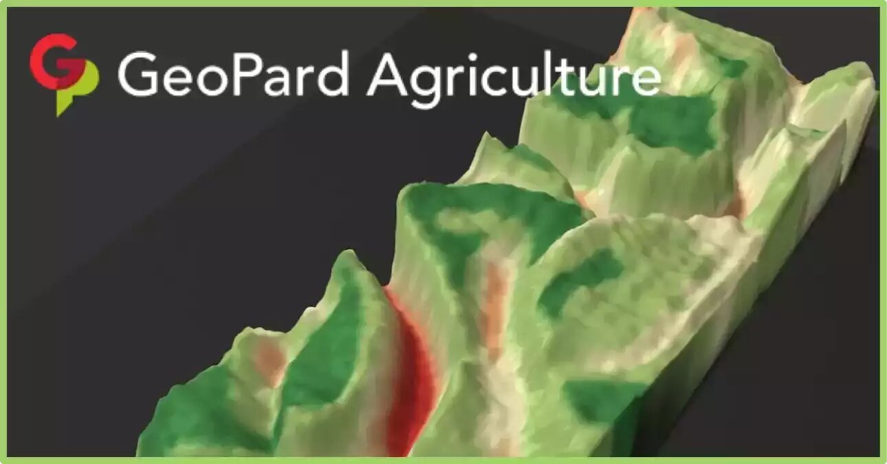
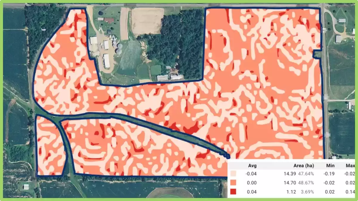
3d topography model overlaid with the Field Potential map

GeoPard is continuing its mission to make such tools more accessible for crop growers. There is no need for a powerful computer or specialized skills to start with data-driven decisions. 

What are Topography maps?

Topography maps, also known as elevation maps, are maps that depict the shape and elevation of the Earth’s surface. These maps use contour lines to show the different elevations of the land, with each line representing a constant elevation above sea level. T

he closer together the contour lines, the steeper the slope of the land, while widely spaced contour lines indicate flatter terrain.

In precision agriculture, they can be used to identify variations in slope and terrain, which can affect the distribution of water, nutrients, and other inputs across a field.

By understanding the 3d topographic maps of their fields, farmers can make informed decisions about planting, irrigation, and drainage, and can implement precision farming techniques such as variable-rate application of inputs.

They can be created using various technologies, including LiDAR (Light Detection and Ranging) and satellite imagery. These maps can be overlaid with other data, such as soil maps and yield data, to create customized prescription maps for precision agriculture applications.

Overall, they are an important tool for precision agriculture, as they provide farmers with a detailed understanding of the terrain and landscape of their fields, enabling them to optimize yields and reduce input costs.

What is 3D mapping in precision agriculture?

3D mapping in precision agriculture is a technique that uses various sensors and imaging technologies to create a detailed three-dimensional map of a farm or field.

The process typically involves the use of drones, airplanes, or ground-based vehicles equipped with sensors that capture images of the area from different angles.

These images are then processed to create a high-resolution 3D map of the field or farm that can be used to identify variations in terrain, soil types, and crop health.

This information can be used to create customized prescription maps for variable-rate application of inputs such as fertilizers, herbicides, and pesticides, and to optimize irrigation and drainage systems.

3D mapping can also be used to identify potential problem areas such as soil erosion or drainage issues, allowing farmers to take proactive measures to address them.

3D topography maps integration with GeoPard precision tool

The 3D mapping tool can be used with any GeoPard base layer in addition to LIDAR topography and its derivatives. Among the additional available layers, there are soil agrochemical properties, yield/as-applied/as-planted datasets, ground scanners data, and even vegetation indices.

Any cover map like zones from yield, historical vegetation, organic matter, electrical conductivity, or pH distribution can be utilized on top of the base layer. The 3D maps help users better understand how relief and topography influence soil properties, vegetation, and yield.

And they contribute to a better visual and analytical understanding of how to manage individual land parcels in the most efficient way. 

It is important to mention, that this Live 3d Model works directly in the browser without any 3rd party pre-installed programs or extensions. You can rotate, zoom in and zoom out, and change cover maps to understand fields better.

The latest improvement includes the capabilities to save the preferred datalayers sets for 3D maps and fastly access them later. This enables saving your current investigation state and continuing further review later.

An additional benefit here is the capability to trace changes through agricultural crop seasons within saved snapshots.

The way topography affects crop vegetation has a significant impact on crop yield (more details are in a previous blog post post here).

The marked areas represent the value of the GeoPard 3D mapping tool, which improves the understanding of the reasons for yield distribution and informs about the necessary changes in planting patterns.

Whatsmore, the 3D topographic maps model provides insight into how watersheds feed into your land and which pathways water takes.

GeoPard’s  3d topographic maps can relay essential information about surface and subsurface drainage inefficiencies, allowing irrigation and drainage systems to be reworked to optimize soil water availability for your crops.

GeoPard is aiming high with the development of new tools like this and is constantly improving and refining its own global understanding related to precision agriculture digital solution demand.

If you are interested in knowing more about how the data is collected and analyzed, feel free to check out this post to learn more!


Frequently Asked Questions


1. How to turn on topography in google earth?

To enable topography in Google Earth, follow these simple steps. First, open Google Earth on your device. Next, navigate to the “Layers” panel located on the left side of the screen.

Click on the “Primary Database” folder, and then select the checkbox next to “Terrain” or “3D Buildings” to display topographic features. You can further customize the appearance by adjusting the transparency or other settings.

With these steps, you’ll be able to view and explore the topography in Google Earth, enhancing your virtual experience of the Earth’s terrain.

2. How to make a 3d model from a topographic map?

Creating a 3D model from a topographic map involves a few steps. First, obtain a high-resolution topographic map of the desired area. Next, digitize the elevation contours from the map using specialized software or by tracing them manually.

Then, import the digitized contours into a 3D modeling software and extrude them vertically based on their elevation values. Finally, add texture and other details to the model to enhance its appearance.

With these steps, you can transform a topographic map into a 3D model, allowing for a more immersive representation of the terrain.

Topographic Models For Machinery and Remote Sensing

Topography often has a huge influence on nutrient distribution and yield potential. GeoPard creates topographic models from machinery, remote sensing and if available LIDAR datasets. 

Let’s dive deeper into the new topographic derivatives we just added to GeoPard.

Relief Position is defined as the difference between a central pixel and the mean of its surrounding cells. In other words, spots with negative values mean field lowland, spots with positive values – field highland.

You can have a hilltop in a “low” elevation that has very different soil properties than a mid slope or depression. Elevation, slope and aspect cannot show this. Relief position is calculated in meters.

Relief Position

Slope is the angle of inclination to the horizontal. Usually, it is calculated in degrees or percent slope. GeoPard does that in degrees.

Terrain slope

Ruggedness is defined as the mean difference between a central pixel and its surrounding cells. In other words, ruggedness describes the slope in absolute numbers (in meters) for every particular location (pixel).

ruggedness describes the slope in absolute numbers

Roughness is the degree of irregularity of the surface. It’s calculated by the largest inter-cell difference of a central pixel and its surrounding cell. In other words, it measures the maximum absolute value of the slope in meters for every location (pixel).

Roughness is the degree of irregularity of the surface.

These four topographic derivatives reflect the slope details but in a bit different flavour.

our topographic derivatives reflect the slope details

What is Topographic Modeling?

Topographic modeling is the process of creating a three-dimensional representation of the Earth’s surface. This is done by collecting data on the elevation of the land, such as through surveying or satellite imagery, and then using this data to create a digital elevation model (DEM).

The DEM can then be used to create a variety of outputs, such as topographic maps, 3D models, and even virtual reality experiences.

It has a wide range of applications, including:

  • Planning and development: Topographic models can be used to plan and develop infrastructure, such as roads, railways, and pipelines. They can also be used to assess the impact of development on the environment.
  • Environmental management: Topographic models can be used to monitor and manage natural resources, such as water, forests, and wildlife. They can also be used to assess the impact of climate change on the environment.
  • Education and research: Topographic models can be used to educate the public about the Earth’s surface and its features. They can also be used by researchers to study the Earth’s surface and its processes.

How is Topographic Modeling Done?

It can be done in a variety of ways, but the most common method is to use a DEM.

A DEM is a gridded representation of the Earth’s surface, with each cell in the grid representing a point with a known elevation. DEMs can be created from a variety of sources, including:

  • Surveying: Surveyors use a variety of tools to measure the elevation of the land, such as levels, theodolites, and GPS receivers.
  • Satellite imagery: Satellites can be used to create DEMs by measuring the distance between the satellite and the Earth’s surface.
  • Aerial photography: Aerial photographs can be used to create DEMs by measuring the distance between the camera and the Earth’s surface.

Once a DEM has been created, it can be used to create a variety of outputs, such as topographic maps, 3D models, and even virtual reality experiences.

Benefits of Topographic Modeling

Further, it offers a number of benefits, including:

  • Accuracy: DEMs are highly accurate representations of the Earth’s surface. This is important for applications such as planning and development, where accuracy is essential.
  • Visualization: Topographic models provide a clear and concise visualization of the Earth’s surface. This can be helpful for understanding the relationship between different features, such as mountains, valleys, and rivers.
  • Analysis: Topographic models can be used to analyze the Earth’s surface. This can be used to identify areas that are at risk of flooding, landslides, or other natural disasters.
  • Communication: Topographic models can be used to communicate information about the Earth’s surface to a wide range of audiences. This can be helpful for educating the public about the Earth’s surface and its features.

What is Topography Lidar?

Lidar (Light Detection and Ranging) is a remote sensing technology that uses light to measure distance to the Earth’s surface. It works by sending out a laser pulse and measuring the time it takes for the pulse to return. This information can be used to create three-dimensional (3D) models of the Earth’s surface.

Topographic lidar is a type of lidar that is specifically used to create 3D models of the Earth’s topography.

How Topography Lidar Works

These systems typically consist of a laser, a scanner, and a GPS receiver. The laser is used to emit pulses of light, the scanner is used to measure the direction of the pulses, and the GPS receiver is used to track the location of the system.

The laser pulses are emitted in a series of lines, and the scanner measures the intensity of the pulses as they return. This information is used to create a 3D model of the Earth’s surface.

Its data accuracy depends on a number of factors, including the power of the laser, the sensitivity of the scanner, and the speed of the GPS receiver.

Applications of Topography Lidar

It data can be used for a variety of applications, including:

  • Mapping the Earth’s surface
  • Monitoring changes in the Earth’s surface
  • Assessing natural hazards
  • Planning infrastructure projects
  • Conducting scientific research

Mapping the Earth’s surface

It can be used to create detailed maps of the Earth’s surface. These maps can be used for a variety of purposes, such as planning infrastructure projects, assessing natural hazards, and conducting scientific research.

Monitoring changes in the Earth’s surface

It can be used to monitor changes in the Earth’s surface over time. This information can be used to track the effects of natural processes, such as erosion and sedimentation, and human activities, such as deforestation and construction.

Assessing natural hazards

It is used to assess natural hazards, such as landslides, floods, and earthquakes. This information can be used to identify areas that are at risk and to develop mitigation strategies.

Planning infrastructure projects

It is used to plan infrastructure projects, such as roads, bridges, and pipelines. This information can be used to identify the best routes for projects and to minimize the impact on the environment.

Conducting scientific research

It can be used to conduct scientific research on a variety of topics, such as geology, hydrology, and ecology. This information can be used to better understand the Earth’s systems and to develop new technologies.

Benefits of Topography Lidar

It has a number of benefits over other methods of mapping the Earth’s surface, including:

  • Accuracy: It is very accurate, making it ideal for applications where precision is important.
  • Speed: It can be collected quickly, making it a cost-effective option for large-scale mapping projects.
  • Flexibility: It can be used to map a variety of features, including both natural and man-made objects.
  • 3D data: It is 3D, which allows for more accurate and detailed representations of the Earth’s surface.

Topographic modeling is a powerful tool that can be used to create a variety of outputs, including topographic maps, 3D models, and even virtual reality experiences. It offers a number of benefits, including accuracy, visualization, analysis, and communication. 

Topography based on machinery data

A lot of data collected from the fields is not used by farmers and agronomists. As an example, almost any modern machinery has a GPS receiver which is capable of gathering elevation data, quite often accuracy is improved with Real-time kinematic (RTK). 

Most of this data is not actively used, because it is quite a time consuming to extract, clean, and process this information to acquire real value out of it. One of the GeoPard main idea is to decrease the complexity of data usage in Precision Agriculture. 

GeoPard is capable of automatically extracting high-accuracy elevation data from:

  • Yield datasets
  • EC/other sensors datasets

GeoPard utilized the best available topography dataset for every field, but, unfortunately, high-accuracy lidar data is not available for every location in the world. Therefore, a machinery data-based digital elevation model will be a perfect option and significantly improves knowledge about the field. 

Henceforth, as any data layer in GeoPard, you can create zones out of machinery elevation data with Zones Creator, use this data in the Zones Ops module (finding of overlappings among different datasets) and use it in multi-layer analytics.

Note that it is also possible to compare remote sensing based VS machinery/RTK based topography models.

What are topographic equipment?

Topographic equipment refers to the specialized tools and instruments used in the field of topography, which is the study and mapping of the surface features of the Earth.

What are topographic equipment

These tools are designed to measure and record various aspects of the land’s topography, including elevation, slope, and contours. Here are some commonly used topographic equipment:

  • Total Station: A total station is an electronic surveying instrument that combines the functions of a theodolite (used for measuring horizontal and vertical angles) and an electronic distance meter (EDM) to measure distances. It is used for precise positioning and measuring angles and distances in topographic surveys.
  • GPS (Global Positioning System) Receiver: GPS receivers use signals from satellites to determine accurate positions on Earth’s surface. In topography, GPS receivers are used to establish control points and measure coordinates, which are crucial for creating accurate topographic maps.
  • Leveling Instrument: Leveling instruments, such as a dumpy level or digital level, are used to measure height differences or elevations between different points on the ground. They help in determining contours and slopes of the land.
  • LiDAR (Light Detection and Ranging): LiDAR is a remote sensing technology that uses laser light to measure distances and create detailed three-dimensional maps. It is commonly used in aerial or ground-based surveys to capture high-resolution elevation data.
  • Photogrammetric Equipment: Photogrammetry involves obtaining measurements from photographs. Specialized cameras, topographer machine, drones, or unmanned aerial vehicles (UAVs) equipped with high-resolution cameras are used to capture aerial images. Photogrammetric software is then used to process these images and extract topographic information.
  • Handheld GPS Devices: Handheld GPS devices provide accurate position data in real-time. They are portable and used for navigation, mapping, and data collection in the field.
  • Field Books and Measuring Tools: Field books are used by surveyors to record measurements, sketches, and notes during topographic surveys. Measuring tools like measuring tapes, ranging poles, and flagging tape are used for measuring distances and marking points of interest.

These are some of the essential topographic equipment used in the field. It’s important to note that technological advancements may introduce new tools or variations of existing equipment, so staying updated with the latest developments is recommended.

What is topographer machine?

A topographer machine, also known as a topographic surveying machine or a topographic mapping system, is a specialized tool used in agriculture for the precise measurement and mapping of the physical features of a field or agricultural land.

What is topographer machine in agriculture

It is designed to capture accurate elevation data and create detailed topographic maps that represent the terrain’s contours, slopes, and other essential characteristics.

The topographer machine typically consists of advanced surveying equipment, including Global Positioning System (GPS) receivers, laser scanners, LiDAR (Light Detection and Ranging) sensors, and onboard computers.

These components work together to collect precise location data and measure the elevation of various points across the agricultural land.

The machine is operated by agricultural professionals or trained technicians who deploy it in the field. As the topographer machine moves through the area, it uses GPS signals to determine its position and laser or LiDAR technology to measure the height of the terrain. The collected data is then processed and analyzed to create accurate topographic maps.

The generated topographic maps provide valuable information to farmers and land managers. They allow for better planning and management of agricultural activities, such as irrigation, drainage, and land leveling.

By understanding the topography of the land, farmers can optimize their farming practices, minimize soil erosion, and enhance overall crop productivity.

In conclusion, topographic equipment plays a vital role in accurately measuring and mapping the surface features of the Earth in the field of topography. The information gathered using these tools is crucial for creating detailed topographic maps, which in turn aid in effective land management, planning agricultural activities, and optimizing farming practices. 

Topography and relief analytics for agricultural fields

Topography is one of the major factors affecting yield and nutrition content in the soil. Thus slope can be a major yield-limiting factor especially for undrained spots or eroded elevated spots, flow accumulation can impact yield significantly depending on dry or wet years.

In some regions, topographical land features can explain even mid-double-digit percentage of yield variability.

As GeoPard is moving towards becoming a powerhouse for ag data analytics, we’ve added advanced topography analysis in the system.

All you need to do is to create a field boundary (draw, import or batch import). GeoPard automatically creates Digital Elevation Model (DEM) for your field, and calculates the following topographic models and combined maps:

  • elevation – absolute numbers;
  • slope – the measure of steepness or the degree of inclination of a feature relative to the horizontal plane;
  • aspect – the compass direction that a slope faces;
  • hillshade – a shaded relief effect for terrain visualization;
  • elevation and hillshades;
  • slope and aspect.

We calculate all these models since only DEM is not enough to accurately determine the field topography, for example, there may be a hilltop in the lowland that will differ in soil characteristics and productivity from other parts of the field with the same height in absolute values – e.g. slopy area, depression. 

These are screenshots reflecting the correlation of topography and multi-year crop development pattern: 

the correlation of topography and multi-year crop development pattern
the correlation of topography and multi-year crop development pattern 2

GeoPard incorporated various digital elevation datasets globally, from LIDAR with 2m spatial resolution in the UK to 30m SRTM, to provide the best possible topography analytics. 

Let us know what other ag data analytics or other elevation derivatives you would like to see in GeoPard Agriculture as the next piece of a yield understanding puzzle!

What are topography factor?

Topography factors in agriculture refer to the characteristics of the land’s surface and its influence on agricultural practices. These factors play a significant role in determining the suitability of an area for farming, as well as influencing various management decisions. Here are some topography factors in agriculture:

Slope

Slope is a crucial topography factor that affects water drainage, erosion, and the accessibility of agricultural machinery. Steep slopes increase the risk of soil erosion and water runoff, requiring erosion control measures such as contour plowing or terracing.

Slope also affects the availability of sunlight, as steeper slopes may cast shadows and influence microclimates within a field.

Elevation

Elevation is the vertical distance of a point or location above a reference point, often mean sea level. It influences temperature, atmospheric pressure, and the types of crops that can be grown in an area.

Higher elevations generally experience cooler temperatures, which may limit the types of crops that can thrive. Elevation also affects the length of the growing season and influences the choice of appropriate crop varieties.

Drainage

The topographic relief of an area determines its natural drainage patterns. Proper drainage is essential for soil aeration, nutrient availability, and preventing waterlogging.

Low-lying areas or depressions may retain excess water, leading to waterlogged conditions that can be detrimental to crop growth.

Understanding the drainage characteristics of the land helps farmers implement effective drainage systems to optimize water movement and prevent water-related issues.

Aspect

Aspect refers to the orientation of a slope in relation to the cardinal directions (north, south, east, west). It affects the distribution of sunlight, wind patterns, and temperature gradients within a field.

South-facing slopes receive more sunlight and heat, creating warmer microclimates and potentially influencing the choice of crops or planting strategies. Aspect can also impact the risk of frost or cold air drainage in certain regions.

Soil Depth and Texture

Topography can influence the depth and texture of the soil in an agricultural area. Slopes can lead to variations in soil depth, with thinner soils found on steeper slopes. The soil texture, such as the proportion of sand, silt, and clay, may also vary based on the topographic relief.

Understanding these variations helps farmers make informed decisions about soil management practices, such as irrigation, fertilization, or tillage.

These topography factors in agriculture demonstrate the importance of considering the characteristics of the land’s surface when making agricultural decisions.

By understanding and managing these factors, farmers can optimize crop growth, prevent soil erosion, and implement appropriate farming practices to ensure sustainable and productive agricultural systems.

What is topographic or local relief?

Topographic relief or local relief in the context of agriculture, refers to the variation in elevation or slope of a piece of land. It is a measure of the vertical difference between the highest and lowest points within a given area. In simpler terms, it represents the topographical features and contours of the land.

What is topographic relief

In agriculture, understanding topographic relief or local relief is crucial as it directly influences various farming practices and management decisions. Here are a few key points to consider:

  • Soil Erosion: It plays a significant role in determining the risk of soil erosion. Steep slopes are more prone to erosion, as water runoff can quickly carry away fertile topsoil and nutrients. Farmers need to adopt appropriate erosion control measures such as contour plowing, terracing, or buffer strips to minimize soil erosion.
  • Water Management: The topographic relief of a field affects water drainage and distribution. It determines how water flows across the land, potentially causing waterlogging in low-lying areas or excessive runoff in steep slopes. By understanding it, farmers can implement proper drainage systems, such as ditches, swales, or tile drainage, to manage water effectively and prevent water-related issues.
  • Crop Selection: Different crops have varying tolerances to slopes and elevation. The relief of a field can dictate which crops are suitable for cultivation. For instance, on steep slopes, erosion risk and water runoff might limit the choice of crops to those that can anchor the soil effectively. On the other hand, flat or gently sloping areas can accommodate a wider range of crops.
  • Machinery Operations: Local relief also influences machinery operations and field accessibility. Steep slopes might be challenging or unsafe for certain machinery, limiting the scope of mechanization. In such cases, farmers may need to consider alternative farming techniques, such as manual labor or specialized equipment designed for steep terrains.

Difference between elevation and relief

Elevation and relief are two distinct concepts related to the topography of agricultural land. Here’s the difference between the two:

Elevation

Elevation refers to the height or vertical distance of a point or location above a reference point, typically mean sea level (MSL). It is an absolute measure that provides information about the vertical position of a specific point on the Earth’s surface.

Elevation is typically measured in units such as meters or feet. In agriculture, elevation data is important for understanding the overall height of the land, which can influence factors like temperature, atmospheric pressure, and water movement.

Relief: What is the it on a topographic map?

Relief, on the other hand, refers to the variation in elevation between different points on the map. It represents the difference between the highest and lowest points in that area.

It is a relative measure that provides information about the vertical differences or changes in elevation across a particular landscape of an agricultural area.

It is typically depicted using contour lines, which connect points of equal elevation, allowing us to visualize the hills, valleys, and slopes present in the landscape. The closer the contour lines are to each other, the steeper the relief, while widely spaced contour lines indicate gentler slopes.

In summary, elevation is an absolute measure of the vertical distance above a reference point (such as MSL), while it is a relative measure that describes the variation in elevation within a specific area or region.

Elevation provides information about the height of a point, whereas it provides insights into the topographic features and slopes of a given agricultural landscape.

Both elevation and relief are important considerations in agriculture as they influence factors such as water drainage, temperature gradients, and suitability for specific crops.

What is an example of topography?

An example of topography in agriculture is the presence of terraced fields on hilly or mountainous terrain. Terracing is a technique commonly used in such areas to create level platforms or steps on the slopes, effectively transforming steep land into cultivable fields.

What is an example of topography

Terraces help mitigate soil erosion by reducing water runoff and allow for efficient water management.

Terraced fields utilize the natural topographic relief to control water movement and maximize agricultural productivity. Each terrace acts as a small flat area that can retain water, preventing it from rapidly flowing downhill and causing erosion.

The walls of the terraces serve as barriers, holding the soil in place and preventing it from being washed away. This method helps to maintain fertile topsoil on the terraces, ensuring optimal conditions for crop growth.

Terracing also allows for better utilization of limited land resources in hilly or mountainous regions. By creating flat areas on slopes, farmers can cultivate crops that would otherwise be challenging or impossible to grow due to steep gradients.

Terraced agriculture has been practiced for centuries in various parts of the world, such as the rice terraces of the Philippines, the vineyard terraces in the Douro Valley of Portugal, or the tea terraces in the hills of China.


Frequently Asked Questions


1. Why is topography important in agriculture? How does it affect food production?

Topography is vital in agriculture as it has a direct impact on food production. It affects water drainage, soil erosion, and crop suitability. It helps plan irrigation systems, manage slopes, and optimize land use. Understanding topography is crucial for efficient and sustainable farming practices.

2. How to identify the aspect of a slope?

Identifying the aspect of a slope can be done using a compass or compass app on a smartphone. Stand on the slope and hold the compass level in front of you, making sure the needle is pointing north.

Read the degree at the direction where the needle points to determine the aspect. For example, if the needle points to 180 degrees, the aspect is south-facing.

This method allows you to determine the cardinal direction of the slope, aiding in understanding sun exposure and microclimate variations.

3. How does relief influence agriculture?

It, or the variation in elevation and slope across a landscape, has significant impacts on agriculture. Steeper slopes can affect water drainage and increase erosion risks, requiring appropriate soil conservation measures.

Slopes can also influence microclimates, with different temperature and moisture conditions on different aspects. Additionally, it can affect soil depth and fertility, influencing crop selection and productivity.

Therefore, properly understanding and managing relief is crucial in optimizing irrigation, minimizing erosion, and selecting suitable farming practices for different areas of a landscape.

4. Why are valley slopes the preferred sites for agriculture in mountainous regions?

Valley slopes are preferred sites for agriculture in mountainous regions due to several reasons. Firstly, valley slopes offer relatively flatter terrain, making it easier for farming activities such as cultivation, irrigation, and mechanization.

Secondly, valleys tend to have better access to water sources, such as rivers or streams, which can be used for irrigation. Additionally, valley slopes provide good sun exposure and protection from strong winds, creating favorable microclimates for crop growth.

Lastly, the natural drainage patterns of valleys help prevent waterlogging, ensuring proper water management. Overall, these factors make valley slopes ideal for agriculture in mountainous regions.

5. How are relief and topography related?

Relief and topography are closely related in the context of geography. Topography refers to the physical features and variations of the Earth’s surface, including elevation, slopes, and landforms.

It, on the other hand, specifically refers to the difference in elevation between the highest and lowest points in a given area.

In other words, it is a measure of the vertical differences in the topography. Together, both provide a comprehensive understanding of the surface characteristics and terrain of a particular region.

6. How to measure elevation of land?

Measuring the elevation of land can be done using various methods. One common approach is to use a Global Positioning System (GPS) device, which can provide accurate elevation readings.

Another method is to use a digital elevation model (DEM), which is a dataset containing elevation information for different locations.

Specialized surveying equipment, such as total stations or laser levels, can also be used for precise measurements. In some cases, traditional methods like barometric pressure measurements or using an altimeter can provide rough estimates of elevation.

wpChatIcon
wpChatIcon

    Request Free GeoPard Demo / Consultation


    By clicking the button you agree our Privacy Policy. We need it to reply to your request.

      Subscribe


      By clicking the button you agree our Privacy Policy

        Send us information


        By clicking the button you agree our Privacy Policy